It looks like you're using an Ad Blocker.
Please white-list or disable AboveTopSecret.com in your ad-blocking tool.
Thank you.
Some features of ATS will be disabled while you continue to use an ad-blocker.

Navy Submarine Base Under the Nevada Desert?
page: 13share:
Seems to me it would make a great nuclear icbm luanch pad
a sub that could sink under the waves after launch and then resurface to luanch another round
seems like it could go on for some time without being noticed or countered.
a sub that could sink under the waves after launch and then resurface to luanch another round
seems like it could go on for some time without being noticed or countered.
ICBM launches are incredibly loud. They can be heard for dozens of miles when they go up. Under some conditions, farther than that. It takes a huge
impulse to pop an ICBM into the air.
reply to post by johnlear
I wish somebody could show us a picture of what these things look like. I keep imagining an underground crystal lucid glass sphere . Really want to know what the heck they need an under water training facility for. That is quite odd.
I wish somebody could show us a picture of what these things look like. I keep imagining an underground crystal lucid glass sphere . Really want to know what the heck they need an under water training facility for. That is quite odd.
Originally posted by Pocky
I wish somebody could show us a picture of what these things look like. I keep imagining an underground crystal lucid glass sphere . Really want to know what the heck they need an under water training facility for. That is quite odd.
#1 ITS DARK VERY DARK
But at the entrance holes it looks like THIS
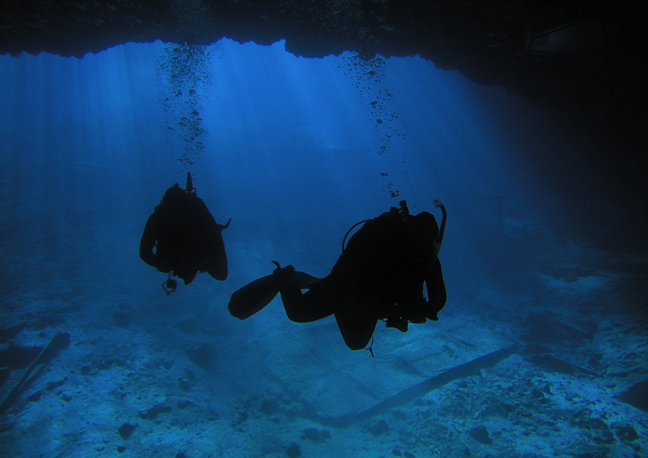
and like THIS
There is a spot in Death Valley... it has a small hole... called Devils Hole... used to be famous dive spot...
Yup Scuba Diving in the Desert... Its closed to the public now because of the fish that live there are endangered... It is a bottomless hole that
Located in southern Nevada, the "hole" itself is a fissure in the earth's surface that split open 60,000 years ago to reveal an astonishing underworld: a water-filled limestone cavern. Ironically, beneath the hottest, driest place in the Western Hemisphere stretches a vast aquifer system. The opening at Devil's Hole is one of the few places in Death Valley where the water from this system meets the surface
There is a cave in Tennesse... the Lost Sea... it too is 'bottomless' What that means is as far as anyone has dared to go... They used ropes and lights to go down and on the 'floor' found more caverns... going inside those the lights would not touch anything... If you have ever been cave diving... you will understand... The Ruby Falls is an underground waterfall taller than Niagara Falls...
The United States and the World is riddled with caves as surface water eats into the rock going ever deeper...
This hole in Death Valley is at one end... I do not know if THIS waterway connects to the sub base... but the land beneath Nevada and California... well its honeycombed with water ways...
In fact I have so much data collected I will have to start another thread on that
As to the Sub Base I bet I will find the rest of the waterways I already have a 'map' of the FIRST layer....
But first meet the famous little fish that lives in this water beneath the hottest driest place on Earth
The Nevada Devil's Hole Pupfish

Area 19 Nevada Test Site
Once Upon a Time... when the boys were playing with the big bombs... they wanted an area a little further from Las Vegas to play with even BIGGER bombs... It always seemed strange to me that after 900 plus nukes they needed to do more and bigger tests... Hey Guys THEY WORK OKAY???
Problem was they were shaking Las Vegas so they moved away...
Area 19 (You Didn't think they numbered Area 51 just for the heck of it did you?)

...The geology of Pahute Mesa makes it possible to test devices at much greater depths than in Yucca Flat (down to more than 13,700 meters (4500 feet))...
Only they ran into a small problem...
...It was the recollection of a former worker at the NTS that "an awful lot of drilling" was done in Area 19, but relatively few nuclear blasts. He says there was a story released that the drillers hit an underground lake, as a result the NTS was not able to fully utilize the area.
More water....
Once Upon a Time... when the boys were playing with the big bombs... they wanted an area a little further from Las Vegas to play with even BIGGER bombs... It always seemed strange to me that after 900 plus nukes they needed to do more and bigger tests... Hey Guys THEY WORK OKAY???
Problem was they were shaking Las Vegas so they moved away...
Area 19 (You Didn't think they numbered Area 51 just for the heck of it did you?)
...The geology of Pahute Mesa makes it possible to test devices at much greater depths than in Yucca Flat (down to more than 13,700 meters (4500 feet))...
Only they ran into a small problem...
...It was the recollection of a former worker at the NTS that "an awful lot of drilling" was done in Area 19, but relatively few nuclear blasts. He says there was a story released that the drillers hit an underground lake, as a result the NTS was not able to fully utilize the area.
More water....
This was a paper that John had pointed to (I believe it was in this thread)
NOTICE All the following data is collected on one page with annotations and links... I will post that at the end...
The Underworld Empire by Branton
Okay sounds wacky... doesn't make sense... but hang on it gets better...
For Pocky here is a description... BTW Have you ever been in underground caverns? If so just picture them full of water...
Now there is one other bit of info before I go on...
Long Beach SINKING? Yeah right what a WACKO... you would think someone would notice THAT
To be continued....
NOTICE All the following data is collected on one page with annotations and links... I will post that at the end...
The Underworld Empire by Branton
The article, titled 'CALIFORNIA FLOATS ON OCEAN?', revealed the following:
"Some time ago, I heard a man on a TV interview-show briefly mention that parts of California and neighboring states are floating on the Pacific Ocean! He was a high ranking Naval officer on a top- secret nuclear submarine that has been (and is) exploring and mapping these enormous caverns and passage-ways underneath the West for over 10 years now.
"A friend of mine finally tracked the man down. He is now living quietly in retirement and asked that no details pointing to him be revealed as he does not want publicity and government attention. After writing this article, I destroyed my files on him. This is his story..."
Williams explains that not "all" of the areas in question are actually "resting" or "floating" on the ocean, however there are allegedly many subterranean cavities below the western U.S., and they are not limited to California, and many of them consist of very large water-filled aqua-systems. These have been explored via nuclear submarines to several hundred miles inland, particularly in the region of southern California and the southern Oregon - northern California area.
Okay sounds wacky... doesn't make sense... but hang on it gets better...
For Pocky here is a description... BTW Have you ever been in underground caverns? If so just picture them full of water...
"He makes the following statements from his observations:
"1. The passageways are labyrinthine with widths from a few to thousands of feet (caverns), averaging roughly about a 100 feet.
"2. Much like dry caverns do, heights and depths vary a great deal and in some cases, two or more caverns or passageways pass over or under each other at different depths.
"3. Most of the entrances lie just off the Continental Shelf (ie. in the Continental Slope - Branton).
"4. Most of the entrances are too small for submarine investigation; and many that are large enough lie in waters that are too deep.
"5. Some of the caverns (in S. California) are topped with oil while some others are filled with gases believed to approximate our atmosphere (in very ancient times).
"6. The San Joaquin Valley is essentially a portion of the original cavernous area that collapsed eons ago due to it's sheer weight.
"7. What is being passed off as the 'San Andreas Fault' are large, unsupported chambers that are in the process of collapsing. When the BIG ONE finally hits, many scientists in the know believe that most of California will break off like a cold Hershey bar and slide into the ocean! (it is postulated by some that an ancient land-mass which some believe may have been connected to what is now California, broke off and sunk into the ocean during an ancient cataclysm - Branton)
"8. (We are deleting this section due to the possibility of undue stress and fear which may result from it's disclosure. Also, because of recent international events which may have resulted in a solution to this problem. We will merely state that it involves a scenario similar to that which was portrayed in a James Bond movie, and which concerned underground caverns, silicon valley, nuclear weapons, and the San Andreas fault - Branton).
"9. A WELL-KNOWN U.S. nuclear submarine lost its way in these passages and disappeared forever. It was reported to have been lost IN OPEN SEA ELSEWHERE to keep the American people in total ignorance and to justify an enormous pay-off to an eccentric U.S. billionaire (who died in recent years) for providing the fictitious "recovery" effort.
Now there is one other bit of info before I go on...
"One incident which tends to confirm the fact that California is in fact floating on the ocean was a story which made the headlines in recent years. This incident involved an oil discovery beneath Long Beach, California. When oil companies began pumping oil out of the ground beneath Long Beach it was soon learned that the entire city BEGAN SINKING INTO THE OCEAN!
Long Beach SINKING? Yeah right what a WACKO... you would think someone would notice THAT
To be continued....
Well funny thing THAT STORY IS TRUE...
Any one that has ever visited Long Beach California has seen the oil pumps all over the city, near the beaches and even in the port. Where is all this oil coming from? Those very underground chambers mentioned above. Below is an excerpt from the History of Long Beach... the part most pertinent to our study...
So there we have our first piece of proof... Long Beach is held up by water as they use sea water to replace the oil they take out. The land sank 25 feet in only a few years.
The Virtual Oral/Aural History Archive
But what about San Joquin Valley?
According to the map John drew there would have to be water ways undee San Joquin Valley to get from Hawthorne to the Pacific at Monteray Bay

To be continued....
Any one that has ever visited Long Beach California has seen the oil pumps all over the city, near the beaches and even in the port. Where is all this oil coming from? Those very underground chambers mentioned above. Below is an excerpt from the History of Long Beach... the part most pertinent to our study...
In the late 1930s, oil was discovered under Long Beach harbor. Its production helped Long Beach recover from the Depression and provided revenue to support expansion and modernization of the harbor as well as enriching individuals who owned land in the area. As a result when land near the oil field began to sink, those who were profiting from pumping the oil out from under the land resisted any suggestion that there could be a link between oil production and subsidence. They hired experts to defend their position. As the subsidence continued, those whose property was damaged by the sinking, but who were not benefiting from the oil production, hired experts to determine what was really causing the sinking.
While the controversy continued, the land kept sinking. It sunk like a big bowl and the bottom of the bowl was more than 25 feet below its previous elevation. Some warned that if the sinking continued, the ocean might inundate the city. The Navy Shipyard was near the bottom of the bowl and the Navy didn't own the mineral rights of the Shipyard so they were suffering damage but receiving no benefit so in 1958 the Navy sued all of the oil operators. Although the suit was never litigated or settled, it helped to convince many people that a proposed solution, pumping water into the fault blocks where the oil had been taken out, should be implemented. And that solution stopped the sinking.
The production of oil from under the harbor led geologists to explore the area under the tidelands and submerged lands off Long Beach and oil was discovered to be there as well. This discovery led to a struggle between the city, to whom the state had granted the tidelands in 1911, and the state and federal governments over control of the oil revenue. Eventually the state and city were forced to divide the money.
So there we have our first piece of proof... Long Beach is held up by water as they use sea water to replace the oil they take out. The land sank 25 feet in only a few years.
The Virtual Oral/Aural History Archive
But what about San Joquin Valley?
According to the map John drew there would have to be water ways undee San Joquin Valley to get from Hawthorne to the Pacific at Monteray Bay
To be continued....
Well lets have a look at San Joquin Valley...
Now I don't want to frighten the children so put the kiddies to bed...
Here is an overhead view

Right away you will notice the depression... but I bet you didn't know that all that irrigation is pumping out the water BENEATH the valley causing it to sink into those waterways
How much you say?
Well... a picture is worth a thousand OH MY GODs
San Joaquin Valley, California
Subsidence Overview

Image from USGS, 1977 This illustration shows how much the Valley sank from 1925 to 1977. The photograph above illustrates subsidence in the San Joaquin Valley, California. In the photo, USGS scientist, Joe Poland shows subsidence between 1925 and 1977 due to fluid withdrawal.
Fortunately the subs are even deeper... but the point here is I have already shown that California and Nevada do indeed "FLOAT" on water
To be continued...
Now I don't want to frighten the children so put the kiddies to bed...
Here is an overhead view
Right away you will notice the depression... but I bet you didn't know that all that irrigation is pumping out the water BENEATH the valley causing it to sink into those waterways
How much you say?
Well... a picture is worth a thousand OH MY GODs
San Joaquin Valley, California
Subsidence Overview
Image from USGS, 1977 This illustration shows how much the Valley sank from 1925 to 1977. The photograph above illustrates subsidence in the San Joaquin Valley, California. In the photo, USGS scientist, Joe Poland shows subsidence between 1925 and 1977 due to fluid withdrawal.
Fortunately the subs are even deeper... but the point here is I have already shown that California and Nevada do indeed "FLOAT" on water
To be continued...
Now I don't want to put all the water data in here... as I said its way to much but I needed to illustrated that the water IS THERE...
I will toss in one more map... this one shows the first level of underground waterways in the USA...

Now if you live in any of the BLUE areas you can expect one of these...

You see that BLUE strip on Florida?
Go to Avon Park , Florida
+27° 35' 52.48", -81° 29' 48.78" on Google Earth
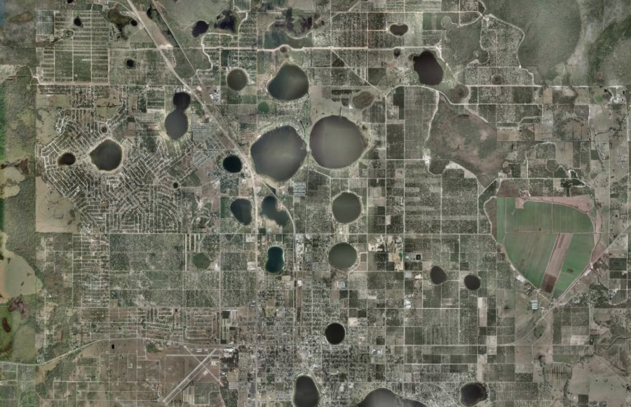
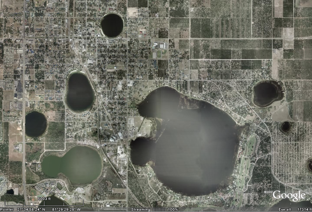
This one took out 4 city blocks Swiss Cheese I tell ya...

OOOOHHH I just thought of a title for that thread..
To be continued....
I will toss in one more map... this one shows the first level of underground waterways in the USA...
Now if you live in any of the BLUE areas you can expect one of these...
You see that BLUE strip on Florida?
Go to Avon Park , Florida
+27° 35' 52.48", -81° 29' 48.78" on Google Earth
This one took out 4 city blocks Swiss Cheese I tell ya...
OOOOHHH I just thought of a title for that thread..
To be continued....
Back to the Base..
When John drove by he wanted to take a snap shot of the NUWC sign on the road... they didn't let him... I found one but seem to have miss placed it... I will look for it...
But in the meantime I found something better... The best info is found in weird places.. In this case one source was an ordinance magazine... and it was pay dirt!!!
No I didn't find the subs yet... but I found the under water mines and the torpedoes.. two items you definitely need at a Naval Underwater Warfare Center Whats really funny is these torpedoes I only found because they were older ones and the NAVY didn't know they still had some...
Here is one being loaded...

Photo by Ray Narimatsu
Rigger Kelsey, left, and Ron Roehmholdt, exhibits director at the Naval Undersea Museum, unload one of 13 World War II submarine torpedoes received at the museum May 4
When John drove by he wanted to take a snap shot of the NUWC sign on the road... they didn't let him... I found one but seem to have miss placed it... I will look for it...
But in the meantime I found something better... The best info is found in weird places.. In this case one source was an ordinance magazine... and it was pay dirt!!!
No I didn't find the subs yet... but I found the under water mines and the torpedoes.. two items you definitely need at a Naval Underwater Warfare Center Whats really funny is these torpedoes I only found because they were older ones and the NAVY didn't know they still had some...
Here is one being loaded...
Photo by Ray Narimatsu
Rigger Kelsey, left, and Ron Roehmholdt, exhibits director at the Naval Undersea Museum, unload one of 13 World War II submarine torpedoes received at the museum May 4
By JO1 Mary Popejoy
Staff Writer
Friday, May 13, 2005
The Naval Undersea Warfare Museum at Keyport welcomed 13 World War II Mk 14 Torpedoes into their space May 4 after 11 years of paperwork, preparation and persistency.
The journey began in 1994 when Dusty Rhodes, Industrial Specialist (Ordnance and Electronics) and a former Master Chief Torpedoman of Naval Undersea Warfare Center (NUWC) Keyport, discovered the historical torpedoes at the Army Ammunition Depot in Hawthorne, Nev.
“We were climbing through magazines in the storage areas at Hawthorne, and Bob Bennett, one of the guys who was helping me out said that he had found some of the “big boy” torpedoes in crates,” said Rhodes. “I went over to where he was standing and noticed a Naval Ammunition Logistical Code (NALC) of 1502 stenciled on one crate. I recognized the number from my days in the Fleet as a Torpedoman’s Mate as being a Mk 14 Torpedo,” he added.
They soon discovered they had eleven of the famous torpedoes....
Northwest Navigator - Puget Sound Naval News
Gotta love those internal news letters
To be continued....
Just a Tourist.... with an interesting personal blog entry...
Sharon Stuart-Brown's Blog
Sunday, June 24, 2007
Nevada ... looks good on you
the-ssb.blogspot.com...
This was the picture I misplaced...
To be continued....
Sharon Stuart-Brown's Blog
Sunday, June 24, 2007
Nevada ... looks good on you
"So we arrived at the Fallon NAS, and the two guys at the gate with machine guns or assault rifles (I don't know the difference, honestly) greeted us. I leaned over from the passenger side to start my rehearsed presentation about how silly this may sound.... One of the soldiers was off to the side, smirking, and the other to whom I was speaking smiled slightly and asked for my documents and ID, and instructed us to pull up to the barricade. He soon returned with my paperwork and said that the rental car guy would come to retrieve us. I was relieved beyond belief that I wouldn't have to unpack my two-weeks worth of belongings! What seemed like an eternity passed before Mr. Hertz showed up at the gate to lead us on a three and a half mile journey through the naval base to the car rental trailer. Yes...a portable office! Before you can say #, I was in my car and making my way back through the naval base, wishing that I could have stopped to photograph this experience. But alas, unauthorized photography was expressly disallowed - and that was made VERY clear along the way. All I really wanted was a picture of the road signs inside the base that said, "YIELD TO LOW FLYING AIRCRAFT"."
"My friends had prepped me for some of the things I would see along the way...bunkers, Area 51, etc. About 3 miles or so outside of Hawthorne, the bunkers popped up. For thousands of acres, all I could see was bunkers in the landscape. Picture the movie, "Alien", with all of the egg pods as far as the eye could see... and this was how the bunkers appeared - though elongated with doors on the side. A sign along the highway read, "NUWC"...then spelled out, Naval Undersea Warfare Center...Wow. In the middle of the desert....go figure. That's what the bunkers were for."
the-ssb.blogspot.com...
This was the picture I misplaced...
To be continued....
Okay Last One... But its a GOODIE... Smoking Gun? Hell No...
How about a ticking underwater mine?
Naval Undersea Warfare Center (NUWC) Detachment Hawthorne
NUWC Detachment Hawthorne in Hawthorne, Nevada serves as the depot and storage organization for the mining community. Its main function is the Receipt, Segregation, Storage, and Issue (RSS&I) of mine commodities. It also performs maintenance on Fleet return materials and conducts demilitarization and disposal actions on mine systems in excess of program requirements.
SOURCE: (CAREFUL HERE Its a secured site)
Comomag.navy.mil/
So Nevada is the Fleets main center for Receiving, Storing and issuing underwater mines...
As Sharon Stuart observed..
" In the middle of the desert....go figure. That's what the bunkers were for."
SOURCE: The Hawthorne Ordnance Museum - Highway 95 in Downtown
Now in closing the piece de resistance.... better than a street sign...
I found their PATCH

Now where is my Hero Cookie... chocolate chip
HAWTHORNE DATA
WATER UNDER DEATH VALLEY
Getting that "Sinking Feeling" in CALIFORNIA
And as an added bonus I promised to scare the kiddies...
THIS is what happens when you pull the plug...
The Swirling Vortex of Doom
How about a ticking underwater mine?
Naval Undersea Warfare Center (NUWC) Detachment Hawthorne
NUWC Detachment Hawthorne in Hawthorne, Nevada serves as the depot and storage organization for the mining community. Its main function is the Receipt, Segregation, Storage, and Issue (RSS&I) of mine commodities. It also performs maintenance on Fleet return materials and conducts demilitarization and disposal actions on mine systems in excess of program requirements.
SOURCE: (CAREFUL HERE Its a secured site)
Comomag.navy.mil/
So Nevada is the Fleets main center for Receiving, Storing and issuing underwater mines...
As Sharon Stuart observed..
" In the middle of the desert....go figure. That's what the bunkers were for."
By 1945, the population had reached 5,625 with the base encompassing some 147,000 acres having 178 buildings and 2,427 above and below ground bunkers for ammunition storage. By 1980, the Depot was converted to a "contractor-operated" facility with a total employment of around 500.
Hawthorne, Nevada
SOURCE: The Hawthorne Ordnance Museum - Highway 95 in Downtown
Now in closing the piece de resistance.... better than a street sign...
I found their PATCH
Now where is my Hero Cookie... chocolate chip
HAWTHORNE DATA
WATER UNDER DEATH VALLEY
Getting that "Sinking Feeling" in CALIFORNIA
And as an added bonus I promised to scare the kiddies...
THIS is what happens when you pull the plug...
The Swirling Vortex of Doom
Zorgon rocks so much. Keep them coming Z, I for one can't get enough!
reply to post by zorgon
I cannot contribute too much to this thread, but I will certainly award Zorgon.............

with a hero, choc chip cookie for the research that he has put into this with some very interesting and very enlightning posts.
Great work Zorgon!
H
I cannot contribute too much to this thread, but I will certainly award Zorgon.............
with a hero, choc chip cookie for the research that he has put into this with some very interesting and very enlightning posts.
Great work Zorgon!
H
Zorgon, you have opened my eyes with the connections you have made and presented here. I had heard of the base but never put the San Juaquin Valley
subsidence and the "swiss cheese" lands of Florida.
In the study of streams and rivers etc there is something called the hyporrheic zone that spreads out way beyond the fast flowing waterway. This Hyporheic zone is habitat for insects and vertebrates. I have heard that one can dig down into river rock and find fish perfectly alive but trapped from the last big flood.
In the study of streams and rivers etc there is something called the hyporrheic zone that spreads out way beyond the fast flowing waterway. This Hyporheic zone is habitat for insects and vertebrates. I have heard that one can dig down into river rock and find fish perfectly alive but trapped from the last big flood.
Originally posted by stikkinikki
In the study of streams and rivers etc there is something called the hyporrheic zone that spreads out way beyond the fast flowing waterway.
I showed you level one water... the 'just below the surface a few hundred to a few thousand feet...
Here is level two...
This water is in rocks 400 to 800 miles (700 to 1,400 kilometers) beneath the surface.

Huge Underground "Ocean" Found Beneath Asia
Richard A. Lovett
for National Geographic News
February 27, 2007
A map depicts large areas of wet underground rock (shown in red) as detected by seismic waves. Scientists studying these waves discovered a giant "ocean" of water under east Asia that contains about as much water as the Arctic Ocean. Map courtesy Eric Chou/WUSTL
news.nationalgeographic.com...
The website of the Indian Navy and is neither endorsed or recognised officially by the Indian Navy or any of its institutions.A navy is the branch of
a country's military forces principally designated for naval warfare and amphibious warfare namely lake- or ocean-borne combat.
-------------------------------------------------------------
Nevada Drug Treatment
-------------------------------------------------------------
Nevada Drug Treatment
From what i have been able to find the navy keeps there tactical nuke torpedoes and mines there plus a few short defensive nuke missiles for ships
The nuke storage is a navy nuke storage area
Within a navy undersea weapons storage area.
Within the hawthorn army ammo storage base.
Because the nuke torpedoes and mines are not counted under any nuke treaties the navy does not want foreign inspectors looking at them and keep them separate at this base from there offencive nuke weapons that are open to inspection under the SALT treaties
[edit on 1-9-2008 by ANNED]
new topics
-
Watts home paranormal activity
Paranormal Studies: 6 hours ago -
So, what is really going on in South Korea ?
World War Three: 6 hours ago -
Congress Says the FBI is Covering Up Vital Info on the Jan 5th 2021 D.C. Pipe Bombs at RNC-DNC.
Political Conspiracies: 7 hours ago -
The trial on kids was stopped
Medical Issues & Conspiracies: 10 hours ago
top topics
-
Biden to award Presidential Citizens Medal to Liz Cheney and Bennie Thompson
US Political Madness: 15 hours ago, 11 flags -
Biden Has New Bizarre Injuries to His Face
Politicians & People: 13 hours ago, 11 flags -
The trial on kids was stopped
Medical Issues & Conspiracies: 10 hours ago, 9 flags -
Congress Says the FBI is Covering Up Vital Info on the Jan 5th 2021 D.C. Pipe Bombs at RNC-DNC.
Political Conspiracies: 7 hours ago, 9 flags -
Orbs Appear And Form Triangle On Live Cam.
Aliens and UFOs: 12 hours ago, 6 flags -
Elon Musk Calls for Tommy Robinson to be Freed - and Takes a Dig at Starmer
Politicians & People: 14 hours ago, 5 flags -
Something is not adding up in regards to the H-1B commotion
General Conspiracies: 14 hours ago, 5 flags -
So, what is really going on in South Korea ?
World War Three: 6 hours ago, 5 flags -
Watts home paranormal activity
Paranormal Studies: 6 hours ago, 3 flags
active topics
-
Congress Says the FBI is Covering Up Vital Info on the Jan 5th 2021 D.C. Pipe Bombs at RNC-DNC.
Political Conspiracies • 22 • : GotterDameron23 -
So, what is really going on in South Korea ?
World War Three • 7 • : MindBodySpiritComplex -
Post A Funny (T&C Friendly) Pic Part IV: The LOL awakens!
General Chit Chat • 7982 • : KrustyKrab -
Tesla Cybertruck Explodes in Front of Trump Hotel in Las Vegas
Mainstream News • 154 • : Guyfriday -
Ukraine halts transit of Russian gas to Europe after a prewar deal expired
Political Conspiracies • 115 • : Flyingclaydisk -
Biden Has New Bizarre Injuries to His Face
Politicians & People • 11 • : berbofthegreen -
The trial on kids was stopped
Medical Issues & Conspiracies • 11 • : annonentity -
-@TH3WH17ERABB17- -Q- ---TIME TO SHOW THE WORLD--- -Part- --44--
Dissecting Disinformation • 3906 • : duncanagain -
Biden to award Presidential Citizens Medal to Liz Cheney and Bennie Thompson
US Political Madness • 14 • : WeMustCare -
The C.D.C. Says There Was NO INFLUENZA Worth Reporting for the 2020-2021 Flu Season.
Diseases and Pandemics • 98 • : WeMustCare