It looks like you're using an Ad Blocker.
Please white-list or disable AboveTopSecret.com in your ad-blocking tool.
Thank you.
Some features of ATS will be disabled while you continue to use an ad-blocker.

2007 Hurricane Season
page: 2share:
What was in the Gulf is now tropical depression 5.
It is expected to be a tropical storm soon and tropical storm watches are up for parts of the coast of Texas...
www.nhc.noaa.gov...
Update - it's now Tropical Storm Erin
Dean is up to 60mph and will likely be the first hurricane of the season.
[edit on 15-8-2007 by ThatsJustWeird]
It is expected to be a tropical storm soon and tropical storm watches are up for parts of the coast of Texas...
www.nhc.noaa.gov...
Update - it's now Tropical Storm Erin
Dean is up to 60mph and will likely be the first hurricane of the season.
[edit on 15-8-2007 by ThatsJustWeird]
TS Erin is expected to hit our coast in a few hours. So far, here in Corpus, we've had very little rain but they say that will change when she hit
land. We're already 15" over our anual rainfall and the rivers are on the verge of flooding.
They expect Hurricane Dean to hit cat 4 by the time it hits the Yucatan and are predicting a westerly track. South Texas really does not need all of this rain.
They expect Hurricane Dean to hit cat 4 by the time it hits the Yucatan and are predicting a westerly track. South Texas really does not need all of this rain.
I am 113 miles NE of Corpus. It has been raining since 2:30. The 7:00AM rain gauge reading was 1.23 inches. Nothing like being in the 'dirty' part
of a storm.
Just what we need - rain.
July 14.83 in
June 6.18 in
Year 53.19 in
The good news is that there is no major wind or thunder storms in the system.
I'll gladly take this one versus a full fledged hurricane.
Just what we need - rain.
July 14.83 in
June 6.18 in
Year 53.19 in
The good news is that there is no major wind or thunder storms in the system.
I'll gladly take this one versus a full fledged hurricane.
Here are some satellite loops of Dean:
Caribbean - Visible Loop
Caribbean - Water Vapor Loop
North Atlantic - Visible Loop
Caribbean - Visible Loop
Caribbean - Water Vapor Loop
North Atlantic - Visible Loop
i'm almost hoping dean swings north and hits the carolinas so we can get some much needed moisture. in any case i hope it dies down enough to cause
as little grief as possible.
The way I see it now is that Dean is going to continue on its current path and either squeeze through the gap between the Yucatan and Cuba or it will
go over the tip of the Yucatan and into the Gulf of Mexico. Sea surface temperatures (SST) are great enough to support development to category five
strength. If this storm makes it into the Gulf it will enter an area of extremely warm waters that have been undisturbed by any tropical system this
year. There is no reason right now for me to believe that this storm couldn't threaten the U.S. Gulf coast as a major category 4/5 hurricane. If I
had to pin a percentage on it I'd give the storm a 30% chance of hitting somewhere between Galveston and Mobile. I'd give the storm a 30% chance of
just going straight into the Cozumel area and on into Mexico without ever coming back out over the waters into the Gulf. I'd give it a 40% chance of
crossing into the Gulf and hitting Mexico or points south of Galveston.
All this is subject to change of course. Time spent over land of course will have a serious negative impact on the strength of the storm. So if it crosses the Yucatan peninsula then don't expect it to hit land as a category 4/5.
All this is subject to change of course. Time spent over land of course will have a serious negative impact on the strength of the storm. So if it crosses the Yucatan peninsula then don't expect it to hit land as a category 4/5.
Quick update...
Dean is now a Cat 4 with winds of 150 mph....
Dean is now a Cat 4 with winds of 150 mph....
Jamaica is getting pounded right now. Eye wall is on shore but the eye isn't which means it'll probably maintain it's strength.....

As you can see above ^ another tropical dression is forming and approaching the Islands. This could be a hurricane in a couple of days
[edit on 31-8-2007 by ThatsJustWeird]

[edit on 31-8-2007 by ThatsJustWeird]
Not looking good for New Orleans, about to get shafted by the look of it...
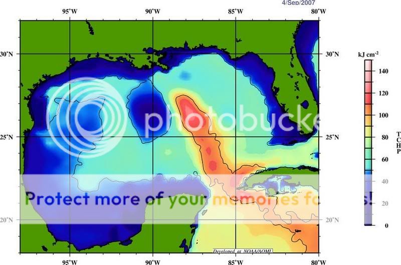
Tropical cyclone heat potential
www.aoml.noaa.gov...
Apparently La Nina conditions developing as well. Looking like a busy season.
[edit on 5-9-2007 by melatonin]
Tropical cyclone heat potential
www.aoml.noaa.gov...
Apparently La Nina conditions developing as well. Looking like a busy season.
[edit on 5-9-2007 by melatonin]
There is a system now out in the Atlantic that might develop into a tropical cyclone and could threaten the U.S. Atlantic coast, anywhere from the
South to New England. This is definitely something to keep an eye on.
Originally posted by djohnsto77
That weather picture looks absolutely pornographic!
There is a system now out in the Atlantic that might develop into a tropical cyclone and could threaten the U.S. Atlantic coast, anywhere from the South to New England. This is definitely something to keep an eye on.
Yeah...
Not looking like much now...
www.ssd.noaa.gov...
....as it's being sheered, but those winds are supposed to relax and with how warm the waters are, it has the potential to develop pretty quickly.
North Carolina would likely be the target


We currently have Sub-tropical storm Gabrielle, formed from the blob along the Mid Atlantic coast.
NHC - Subtropical Storm GABRIELLE Forecast/Advisory
NHC - Subtropical Storm GABRIELLE Forecast/Advisory
A TROPICAL STORM WATCH HAS BEEN ISSUED FOR PORTIONS OF THE SOUTH
CAROLINA AND NORTH CAROLINA COAST FROM EDISTO BEACH NORTHWARD TO
OREGON INLET...INCLUDING THE PAMLICO SOUND. A TROPICAL STORM WATCH
MEANS THAT TROPICAL STORM CONDITIONS ARE POSSIBLE WITHIN THE WATCH
AREA...GENERALLY WITHIN 36 HOURS.
complete 11pm advisory on Subtropical Storm Gabrielle
National Hurricane Center
currently winds are at 40mph with higher gusts and only 2-4 inches of rainfall is expected with this storm. However there is the slight possibility that STS Gabrielle could intensify during the day tomorrow and into tomorrow night.
National Hurricane Center
currently winds are at 40mph with higher gusts and only 2-4 inches of rainfall is expected with this storm. However there is the slight possibility that STS Gabrielle could intensify during the day tomorrow and into tomorrow night.
We've already had Henriette, and now there's Gabrielle. I thought these storms were named alphabetically? As far as I know, "G" is still before
"H" in the alphabet... Or maybe there's something I missed?
[edit on 2007/9/8 by Hellmutt]
[edit on 2007/9/8 by Hellmutt]
Originally posted by Hellmutt
We've already had Henriette, and now there's Gabrielle. I thought these storms were named alphabetically? As far as I know, "G" is still before "H" in the alphabet... Or maybe there's something I missed?
Henriette was a Pacific basin storm, Gabrielle is an Atlantic basin storm. The different basins have different name lists.
See en.wikipedia.org...
[edit on 9/8/2007 by djohnsto77]
It looks like TS Gabrielle is just going to clip the North Carolina coast then go back out to sea:

3 new areas to watch for potential storm development
Experimental Graphical Tropical Outlook
I think the are numbered "1" aka invest 91L has the most potential and probability of becoming our next named system which would be (Humberto) and hopefully it recurve out to sea because on that graphic, it looks huge!
Experimental Graphical Tropical Outlook
I think the are numbered "1" aka invest 91L has the most potential and probability of becoming our next named system which would be (Humberto) and hopefully it recurve out to sea because on that graphic, it looks huge!
Hurricane Humberto made landfall this morning. The first landfalling hurricane (in the U.S.) since '05...
I thought it was going to remain a tropical storm but he had other plans and gained strength overnight.
Tropical Depression 8 is still out there. Still trying to get it's act together
www.nhc.noaa.gov...
I thought it was going to remain a tropical storm but he had other plans and gained strength overnight.
Tropical Depression 8 is still out there. Still trying to get it's act together
www.nhc.noaa.gov...
new topics
-
World's Best Christmas Lights!
General Chit Chat: 2 hours ago -
Drone Shooting Arrest - Walmart Involved
Mainstream News: 2 hours ago -
Can someone 'splain me like I'm 5. Blockchain?
Science & Technology: 3 hours ago -
Squirrels becoming predators
Fragile Earth: 3 hours ago -
Labour's Anti-Corruption Minister Named in Bangladesh Corruption Court Papers
Regional Politics: 4 hours ago -
Have you noticed?? Post Election news coverage...
World War Three: 4 hours ago -
Georgia appeals court disqualifies DA Fani Willis from Trump election interference case
US Political Madness: 7 hours ago
top topics
-
Georgia appeals court disqualifies DA Fani Willis from Trump election interference case
US Political Madness: 7 hours ago, 24 flags -
Have you noticed?? Post Election news coverage...
World War Three: 4 hours ago, 9 flags -
Squirrels becoming predators
Fragile Earth: 3 hours ago, 8 flags -
Labour's Anti-Corruption Minister Named in Bangladesh Corruption Court Papers
Regional Politics: 4 hours ago, 6 flags -
Drone Shooting Arrest - Walmart Involved
Mainstream News: 2 hours ago, 5 flags -
World's Best Christmas Lights!
General Chit Chat: 2 hours ago, 5 flags -
Can someone 'splain me like I'm 5. Blockchain?
Science & Technology: 3 hours ago, 3 flags
active topics
-
Russias War Against Religion in Ukraine
World War Three • 46 • : andy06shake -
Squirrels becoming predators
Fragile Earth • 24 • : rickymouse -
Can someone 'splain me like I'm 5. Blockchain?
Science & Technology • 23 • : CriticalStinker -
Drone Shooting Arrest - Walmart Involved
Mainstream News • 12 • : BeyondKnowledge3 -
The Mystery Drones and Government Lies --- Master Thread
Political Conspiracies • 144 • : charlyv -
US Federal Funding set to Expire December 20th. Massive CR on the way.
Mainstream News • 26 • : burntheships -
It's time to dissect the LAWFARE
Dissecting Disinformation • 18 • : burntheships -
World's Best Christmas Lights!
General Chit Chat • 5 • : onestonemonkey -
Labour's Anti-Corruption Minister Named in Bangladesh Corruption Court Papers
Regional Politics • 6 • : Partridge -
Georgia appeals court disqualifies DA Fani Willis from Trump election interference case
US Political Madness • 15 • : burntheships