It looks like you're using an Ad Blocker.
Please white-list or disable AboveTopSecret.com in your ad-blocking tool.
Thank you.
Some features of ATS will be disabled while you continue to use an ad-blocker.

More Evidence -Flight 93 Photo Fraud
page: 3share:
The print-outs would help how?
I saw your other post on this, with a few additional pics with "what if" scenarios, like the plume being just the other side of the barn. I thought that, too, but clearly, it couldn't have been without fighters being seen (shootdown) and a loud explosion being heard (you wouldn't miss it).
www.abovetopsecret.com...
Originally posted by mirageofdeceit
The print-outs would help how?
I didn't know if the print out would give any more detail than seeing the pic on a monitor.
BTW, here's the front of McClatchey's house. I found this on the Somerset County real estate website.
I'm interested in this view of her house as it relates to the gutter in the foreground of her shot. Where would she have to be standing? In front of the windows, right?
This would contradict her story that she took the photo from her front porch, and make it seem more likely that she stood in a place that would give her the best composition for her now famous pic. At least that's my theory...
Where Was Photo Taken From?
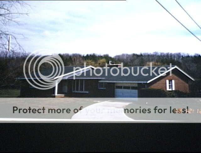
Notice Gutter in Upper Right Corner
Good teamwork dudes! Keep it up, I'm doubting this somewhat less.
Originally posted by Caustic Logic
Good teamwork dudes! Keep it up, I'm doubting this somewhat less.
Thanks!
This might make you think twice too....
McClatchey sobbed on video about her financial ruin because of 9/11. She went on to talk about how she has to go out with a briefcase to support her family. Her husband filed bankruptcy on 9/20/01.
Well...
Here's her hubby's real estate holding in Somerset County:
MC CLATCHEY JOHN C S19-040-081-01 ?? $3000
MC CLATCHEY JOHN C S19-040-108-00 107 OSAGE PATH $188,000
MC CLATCHEY JOHN C S19-040-150-01 SIOUX PATH .9 acres $1880
MC CLATCHEY JOHN C S19-040-155-00 SIOUX PATH ??? $1820
MC CLATCHEY JOHN C S19-040-153-01 144 N SHORE TR 4.6 Acres $223,000
MC CLATCHEY JOHN C S19-040-152-00 3.3 Acres $8000??
About 10 acres appraised at over $400,000, with other lots apparently seriously under-appraised.
A 3.3 acres lot at only $8,000?
Two lots at Indian Lake for only $1,800?
I think McClatchey is fibbing a little...
Here's the link to the Somerset County real estate website. To look up McClatchey's by name, you have to enter MC [space] CLATCHEY.
www.co.somerset.pa.us...
Also, just for fun, check out pbs mining...
PS...
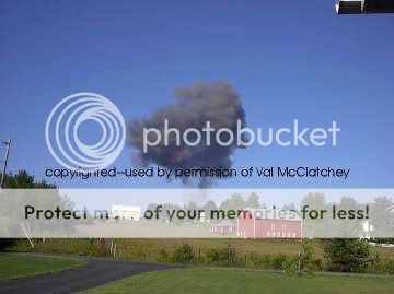
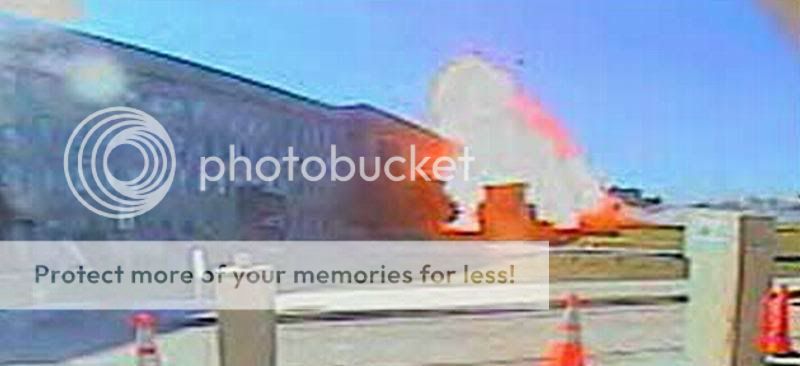
You can also check out the news videos from the crash site. All the live videos show the smoldering smoke from the crater and woods blowing away in a fairly brisk breeze. The smoke plume in the McClatchey video shows no signs of being blown by the wind.
IMO, this is why she had to come up with the "I took the picture 5 seconds after the crash" story. Any longer, and the wind would dispersed the cloud. There is NO dispersion of the plume in Val's photo.
[edit on 24-2-2007 by nick7261]
[edit on 24-2-2007 by nick7261]
Thanks!!
Judging by where the sun is in this shot, and where it was on the day of the events, I think she was stood where the arrow is.
BIG question: on all the maps/photos, where is NORTH? This is important. Need to remember that the sun was rising in the East and that she was looking West. I'm assuming the map of the crash site shows North to be UP.
[edit on 24-2-2007 by mirageofdeceit]
[edit on 24-2-2007 by mirageofdeceit]
Originally posted by mirageofdeceit
Thanks!!
Judging by where the sun is in this shot, and where it was on the day of the events, I think she was stood where the arrow is.
BIG question: on all the maps/photos, where is NORTH? This is important. Need to remember that the sun was rising in the East and that she was looking West. I'm assuming the map of the crash site shows North to be UP.
[edit on 24-2-2007 by mirageofdeceit]
[edit on 24-2-2007 by mirageofdeceit]
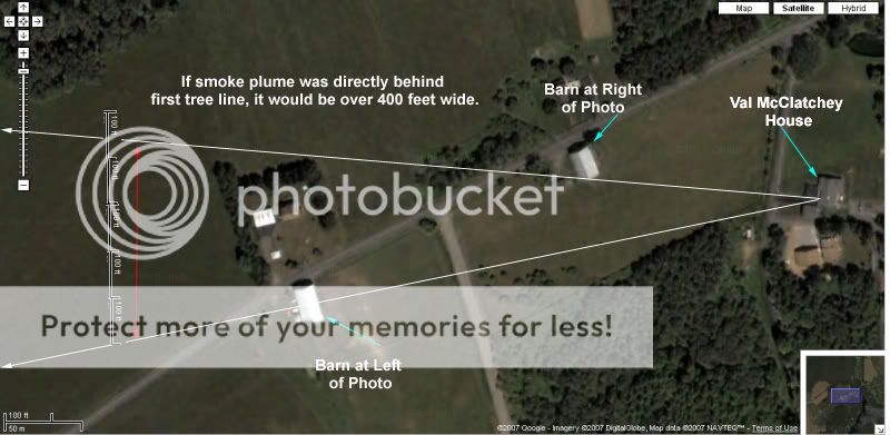
Here's a close-up shot of the house and the barns from overhead... north is up.
Also, if you look very closely at the bushes in the field in the photo, it looks like they have shadows falling from left to right in the photo, which would put the sun in the south, not east behind the house which is where you would expect it to be at 10:00 am on Sept. 11.
McClatchey's uncropped photo
Bushes from Post-Gazette version of photo

[edit on 24-2-2007 by nick7261]
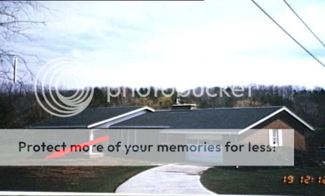
Look VERY carefully at the roof line of the satellite photo vs. the estate agent photo. It isn't the same building.
Originally posted by mirageofdeceit
Look VERY carefully at the roof line of the satellite photo vs. the estate agent photo. It isn't the same building.
Which roofline?
Which photo??
sorry, I'm a little dense sometimes....
OH... you mean the driveway? They re-did the driveway. Is that what you're referring to?
[edit on 24-2-2007 by nick7261]
In the photo of the house taken from the ground, look carefully at the roof line, and note the chimney.
Next, look carefully at the outline of the roof of the house in the satellite photo. You have to be aware that you're looking at the side vs. the top, but if you trace the outline carefully (using the chimney as a reference point) it doesn't seem right. It is close, but there are a few differences that seem significant.
I don't have the time that I'd like to right now to draw lots of diagrams explaining what I'm looking at.
Originally posted by mirageofdeceit
In the photo of the house taken from the ground, look carefully at the roof line, and note the chimney.
Next, look carefully at the outline of the roof of the house in the satellite photo. You have to be aware that you're looking at the side vs. the top, but if you trace the outline carefully (using the chimney as a reference point) it doesn't seem right. It is close, but there are a few differences that seem significant.
I don't have the time that I'd like to right now to draw lots of diagrams explaining what I'm looking at.
I think I see what you mean. The photo of the house is out of date. I know they added a blacktop driveway and a garage, plus a walkway in front.
The photo of the house is out of date.
Ahh, OK!
In that case then, if I've got what I can make out orientated right, then looking at the house from the ground (as in that photo), she would be standing on the far side of the house, looking to the right of the pic.
Have you actually been there then to have a look?
Originally posted by mirageofdeceit
The photo of the house is out of date.
Ahh, OK!
In that case then, if I've got what I can make out orientated right, then looking at the house from the ground (as in that photo), she would be standing on the far side of the house, looking to the right of the pic.
Have you actually been there then to have a look?
Yeah, I was there a couple of times in the last few weeks. I have business in the area occasionally, and I wanted to drive by the place to get a first-hand look at the scale of the area.
The crash site is VERY far visually from the house. Once you see it first hand, it becomes pretty obvious the photo can't be real. I mean that cloud would have been HUGE, visible to people all over the area.
There aren't any witnesses that I've read about that said they saw a smoke plume, except for those right near the crash site. And even then, their descriptions don't match up with Val's photo at all. The most common account I've read is that the smoke cloud went up about 200 feet. If Val's photo is accurate, it went up more like 2000 feet!
People in Somerset and along the PA turnpike would have seen a cloud that big. Plus, the cloud in Val's pic isn't over the crash site, it's several hundred yards south.
What's also strange is that both Val and other people at Indian Lake said a plane went over their heads. This clearly contradicts the official story that has Flight 93 coming from the norhtwest, not the east.
What are other signs, generally speaking, that give away a faked pic?
Originally posted by nick7261
Originally posted by mirageofdeceit
The photo of the house is out of date.
Ahh, OK!
In that case then, if I've got what I can make out orientated right, then looking at the house from the ground (as in that photo), she would be standing on the far side of the house, looking to the right of the pic.
Have you actually been there then to have a look?
Yeah, I was there a couple of times in the last few weeks. I have business in the area occasionally, and I wanted to drive by the place to get a first-hand look at the scale of the area.
The crash site is VERY far visually from the house. Once you see it first hand, it becomes pretty obvious the photo can't be real. I mean that cloud would have been HUGE, visible to people all over the area.
Very true.
There aren't any witnesses that I've read about that said they saw a smoke plume, except for those right near the crash site. And even then, their descriptions don't match up with Val's photo at all. The most common account I've read is that the smoke cloud went up about 200 feet. If Val's photo is accurate, it went up more like 2000 feet!
I think we can safely say it is rubbish.
People in Somerset and along the PA turnpike would have seen a cloud that big. Plus, the cloud in Val's pic isn't over the crash site, it's several hundred yards south.
Which way was the wind? Was it a North-Westerly?
What's also strange is that both Val and other people at Indian Lake said a plane went over their heads. This clearly contradicts the official story that has Flight 93 coming from the norhtwest, not the east.
If the FAA hadn't kicked everyone out of ATC......
What are other signs, generally speaking, that give away a faked pic?
A tough one to answer, but generally I start by looking at items such as:
* What is in the pic?
* What is in focus and where?
* What isn't in focus?
* The overall quality of the pic in general
* The quality of the bit in question
* Brightness/contrast of the whole thing
* Shadows and light sources (or lack thereof)
* Other artifacts that suggest editing.
It can take me several hours to scrutinize a photo.
It is why I keep thinking that the overhead sat-photo style photo of the crash site looks computer generated; the photo fails item 4 in the list above. My gut tells me it is wrong, and it is usually right.
The land looks too flat, insufficient brightness and contrast considering it was a bright sunny day. The smoke looks highly suspect, too.
Where on Google maps can I find the crash site? A crater that big would be visible from the air for years afterwards. You only have to look at old airfields that were dug up and the land reclaimed; from the air they are still visible (outlines of runways etc).
[edit on 26-2-2007 by mirageofdeceit]
its been stated taht hte plume went up an estimated 2000 feet.
wouldnt that be a bit low if it was from the plane being shot down? why would the plane be under 5k ft? or even under 20k ft?
just wondering...
wouldnt that be a bit low if it was from the plane being shot down? why would the plane be under 5k ft? or even under 20k ft?
just wondering...
Originally posted by nick7261
Originally posted by purplecoral
(im not arguing....) what do you think this smoke plume is then?
Personally I think the plume was photoshopped into the shot. She's very protective of the copyright, and has even filed a suit against AP for using her photo.
If she and her family were really so financially strapped, why/how could she afford to file a lawsuit that's going to result in little, if any, damages even if she wins?
She also sells copies of the photo for $20 a pop, and claims to give $18 of each sale to the Todd Beamer Foundation.
Anybody else know of another person who took a photo of ANYTHING on 9/11, then copyrighted the photo and is selling it?
The FBI went on record as saying the photo is real.
I'm going out on a limb here to predict that this photo will be the FIRST part of the 9/11 story to be exposed, and confirmed, as a fraud.
This is why skeptics are skeptical.
To satisfy the conditions that conspiratorialists attach to 9/11, not only must we dismiss many credible witnesses, but also believe in holographic planes, cruise missles, planted airplane parts, staged knocked down light poles, thermite, black helicopters remotely detonating the thermite, the silence of the 100's if not 1,000s of people required to pull off the events ...but we must also believe in non-participants in the plan who are perpetrating fraud on their own behalf, independently of the main conspirators.
Originally posted by darkbluesky
To satisfy the conditions that conspiratorialists attach to 9/11, not only must we dismiss many credible witnesses,
You mean like the NEADS and NORAD officers who testified in front of the 9/11 Commission? You know, the officers whose testimony that the 9/11 Commission dismissed as being "mistaken"?
Or Col. Anthony Schaffer from the Able Danger unit?
Yeah, I know it's tough making sense of all this when you need to dismiss testimony of lifetime military officers to make the "al-Qaeda surprise attack" theory fit.
...but we must also believe in non-participants in the plan who are perpetrating fraud on their own behalf, independently of the main conspirators.
I have no idea why Val McClatchey is perpetrating a fraud. I'm just looking at the photo she claims to be from Flight 93 crashing. It's not legit. It's far out of scale. I also have no idea why the FBI is backing her story about the photo.
I'm not asking you to believe all the other things you mentioned. Just look at this thread with an open mind and independent thinking. The math doesn't lie. There's no way the smoke plume was 2300 feet wide, or over 2000 feet high. But that's what Val's photo shows.
Either she faked the photo, or something else much closer to her home made the smoke plume.
Q: How could Flight 93 have created this big of a smoke plume from the crash, and yet fail to burn the grass next to the crater it supposedly left??
A: It couldn't!!
i have to give you that one , i DO NOT think the gov did 911 , but from that on vantage point , theres no burnt grass . nice find ... but -
thats just one vantage point and it could be flawed.
your " drawn to scale " picture of the wtc next to that barn
is , well ,
im no expert , but thats WAY off ! ive never seen a 700ft tall barn ...till now
edit - jus saw this quote -
" No, it's not a joke.
It's a serious scientifical optical study "
what the hel$ is scientifical ? it's hard to take amature studies seriously when one uses words like that . sorry , just m2c.
[edit on 26-2-2007 by rainking]
[edit on 26-2-2007 by rainking]
[edit on 26-2-2007 by rainking]
Originally posted by nick7261
I have no idea why Val McClatchey is perpetrating a fraud. I'm just looking at the photo she claims to be from Flight 93 crashing. It's not legit. It's far out of scale. I also have no idea why the FBI is backing her story about the photo.
I'm not asking you to believe all the other things you mentioned. Just look at this thread with an open mind and independent thinking. The math doesn't lie. There's no way the smoke plume was 2300 feet wide, or over 2000 feet high. But that's what Val's photo shows.
Either she faked the photo, or something else much closer to her home made the smoke plume.
Consider that all fireball explosions create a mushroom cloud.
Also consider that 1000's of pound of jet fuel can easily create an initial fireball 200-300 ft in diameter:
Exhibit A:
Note in the following Google video of a small mushroom cloud created by a car crash, that the smoke cloud is the same size as the large fireball. Also note that the large fireball is approximately 7-8 times larger in diameter than smoke/fire column resulting from the initial explosion.
Exhibit B:
Google video of car crash fireball w/ mushroom cloud
It doesn't seem impossible to me that the crash would have created a fireball of 200-300 ft., or that initial fireball of 200-300 ft. in diameter could create mushroom cloud with on overall diameter of 2300 ft. The proportions of the column to the main cloud in the McClatchey photo are consistent with example shown here, and most other photos of mushroom clouds I've seen.
Here is a Wiki article on mushroom clouds:
en.wikipedia.org...
[edit on 2/26/2007 by darkbluesky]
Hmmmmm......
I didn't buy into the fake photo thing, only because I believe that to be a real picture taken immediately after the plane was shot down (reason the plume is so high).....
However....I did check out those real estate holdings.
Honestly as much as I wanted to think you (Nick) were a jerk for posting that stuff, It is very obvious that those values are BS.
There is no way in hell any type of structure on a piece of land at Indian Lake is only worth $1,800.00. It just is not possible. An outhouse on .9 acres is worth more than that. I'm still trying to wrap my mind around this one, how the building has no worth at all......*shaking head*
I'll give an example.....a .95 acre piece of land, in Trent, oh...about 7 miles from Seven Springs, is worth $9800.00. There is just no way that land is only $1800.00 with the building being worth nothing.
I'm going to have to reassess everything about this thread.....you've done a lot of work Nick. Sorry for being such a witch. I know other people saw a smoke plume........but now I'm thinking you're right, it was a different one.
Another thing, I'm guessing you've been to the crash site.....was it windy? Every single time I have been there it has been windy. Even if it isn't windy anywhere else. Could be my imagination......but if it is always windy there due to whatever factors, wouldn't that have altered the smoke as well.
new topics
-
United Nations adopts ground-breaking Pact for the Future to transform global governance
New World Order: 9 hours ago
top topics
-
ATTENION ATTENTION - 150k to kill the former President of the United States
US Political Madness: 14 hours ago, 26 flags -
United Nations adopts ground-breaking Pact for the Future to transform global governance
New World Order: 9 hours ago, 15 flags -
SpaceX plans to launch about five uncrewed Starships to Mars in two years.
Space Exploration: 14 hours ago, 12 flags -
What makes you who you are? How do you define your self?
Philosophy and Metaphysics: 14 hours ago, 7 flags -
asteroid as second moon, how will earth react?
Space Exploration: 15 hours ago, 6 flags -
Vladimire Putin and His Alleged Occult Practices
Politicians & People: 13 hours ago, 6 flags
active topics
-
United Nations adopts ground-breaking Pact for the Future to transform global governance
New World Order • 13 • : Terpene -
Over 1,100 Migrants Arrived in First 10 Days of Labour Government
Social Issues and Civil Unrest • 379 • : BedevereTheWise -
ATTENION ATTENTION - 150k to kill the former President of the United States
US Political Madness • 83 • : SourGrapes -
War is coming in months not years Chicago
US Political Madness • 43 • : WeMustCare -
The Navy no longer needs a GED or high school diploma to accept recruits.
World War Three • 19 • : WeMustCare -
I need some Wisdom and Understanding .
Philosophy and Metaphysics • 39 • : Compendium -
What makes you who you are? How do you define your self?
Philosophy and Metaphysics • 8 • : SecretKnowledge2 -
Let's Talk Reparations .
Political Issues • 63 • : Asktheanimals -
-@TH3WH17ERABB17- -Q- ---TIME TO SHOW THE WORLD--- -Part- --44--
Dissecting Disinformation • 2698 • : RelSciHistItSufi -
Israel Launches 2nd Wave Of EXPLODING TECH, Hezbollah Radios Begin Exploding
World War Three • 103 • : WeMustCare