It looks like you're using an Ad Blocker.
Please white-list or disable AboveTopSecret.com in your ad-blocking tool.
Thank you.
Some features of ATS will be disabled while you continue to use an ad-blocker.

Google maps being "photoshopped"
page: 10
share:
I was messing around with a similar service as Google maps over my hometown. And I figured I´d check out a military installation that I actually
worked at for some short periods of time about 10 years ago.
HAving spent quite some hours out there I had a fairly good idea of how it was going to look from a satellites point of view. But to my amazement when I zoomed down to the ground, I found that the road that is on the base and leading down to the "interesting area" ended in a smudgy patch of dirt/trees. And beyond this line were more trees and vegitation.
I know that this is not how its supposed to look, and started thinking if these services actually "photoshop" some of the more secret areas for the military. In this case I dont know why they would do such a thing though. At the very tops you should see a loading ramp and perhaps a hint 1-2 entry points.
I checked the same area with google maps but the zoom level ends way before you can make any sense.
I never signed any papers to not speak of this base when I worked there but I gave a verbal vow not to disclose about anything I saw at this installation. But I guess I can say that its not underground (to my knowledge), neither is it a normal building.
I never saw anything ULTRACOOL at this installation but you know I wasnt allowed to enter certain points. Perhaps the reason why they are hiding this place now is taht its more active than 10 years ago. My contact out there isnt working there anymore an has little contact with the place at all.
Another funny thing was how at one point, all of us not permantly working there were suddenly not allowed in certain areas where we previously had been. A real bummer, but also strenghtened my belief no in hindsight that there could have been more than met the eye to this place.
So does anyone else know of military roads ending in a photoshopped nowhere?
Hopefully Ill be able to question my contact about this... I just dont believe he/she will be able to give me anything intertesting about it, other than stating the obvious.
also, this is not in the US. Somewhere in Europe
I noticed a while back that Google Maps changed the roof of the White House and added trees to the surrounding grounds. The same changes are shown in
the images from NASA Worldwind.
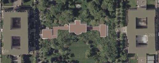
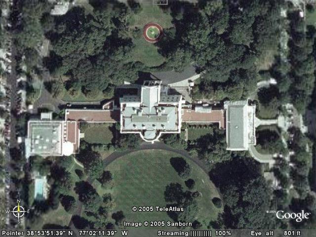
If you look at the White House with Google Earth though, the roof is visible and the extra trees are gone.
Not sure why one Google program would be edited but not the other.
If you look at the White House with Google Earth though, the roof is visible and the extra trees are gone.
Not sure why one Google program would be edited but not the other.
Originally posted by anxietydisorder
Not sure why one Google program would be edited but not the other.
hmm, weird. Perhaps to start confusion on which is the true picture. My belief was that anything really sensitive was always going to have a "zoom restriction". That would also be the most easy solution to implement. They wouldn´t have to to do a new photoediting job when the satellite image is updated.
I love GE because the sensitive areas are always obscured by something, like clouds.
Ah, yes. Of course Google needs to have limitations. We don't want Bin Laden getting ideas that a certain something is here and could blow up.
Ah, yes. Of course Google needs to have limitations. We don't want Bin Laden getting ideas that a certain something is here and could blow up.
I'm surprised more isnt censored considering most big prisons cant be photographed, like for instance the mens colony (folsum state penn) in cali has
a sign out front saying its illegal to take pics....seems like google earth or any other similiar programs would be breaking the law.
google maps white house is now different than the picture posted above, weird
The google maps seems to be unaltered now of White House, the one above is heavily photoshopped.
OP, If I understand correctly you worked on a base, which is known to be a base by the general public, so why not locate the base for us, you would not be breaking any secrecy laws, because you are only pointing to a known base. Even if it's supposed to be secret it is probably a known secret base.
Like me pointing to this base
maps.google.co.uk...,-4.149313&spn=0.026035,0.05785&t=k&om=1
Or this one (slightly secret :p)
maps.google.co.uk...,-1.398139&spn=0.012243,0.028925
Or this one
maps.google.co.uk...,0.466458&spn=0.0015,0.003616
Originally posted by SdiRailgun
Originally posted by anxietydisorder
Not sure why one Google program would be edited but not the other.
hmm, weird. Perhaps to start confusion on which is the true picture. My belief was that anything really sensitive was always going to have a "zoom restriction". That would also be the most easy solution to implement. They wouldn´t have to to do a new photoediting job when the satellite image is updated.
Or maybe it could just be that the 2 pictures of the white house was taken at different times in which the tree arrangement was different...ahem
Originally posted by NegativeBeef
Or maybe it could just be that the 2 pictures of the white house was taken at different times in which the tree arrangement was different...ahem
No, that's not the case at all.
The roof of the White House and the buildings on either side have been masked out, and the grounds of the White House has more trees added.
The picture I posted was from Google Maps from about a year ago.
This same topic was discussed in this thread of mine:
politics.abovetopsecret.com...
The member "astroblade" posted this picture from Google Earth at the same time.
The difference is pretty obvious.
They've changed the the images to conceal many details in the original Google Maps pic.
It's your settings on GE not the picture. I just went to GE Whitehouse and alls well there. You have a building overlay trurned on.
mikell
mikell
Originally posted by mikellmikell
It's your settings on GE not the picture. I just went to GE Whitehouse and alls well there. You have a building overlay trurned on.
No, I didn't have a building overlay turned on.
Google Maps and Google Earth are two different services. The masked picture was a screen capture I took about a year ago from Google Maps and has since been changed to match the data on Google Earth.
I just pulled this screen capture from NASA World Wind Five minutes ago.
They still have the original imagery that was used when Google Maps first came out. There are no building layers turned on and you can clearly see that trees have been added to the image to hide features on the grounds and the three rooftops have been painted out.
maps.google.com...
earth.google.com...
worldwind.arc.nasa.gov...
You can take a look a World Wind if you doubt my veracity. And if you don't want to download the NASA software you can take a look at Terraserver and see the same thing.
terraserver.microsoft.com...
It's an obvious case of Photoshop, or whatever software they use.
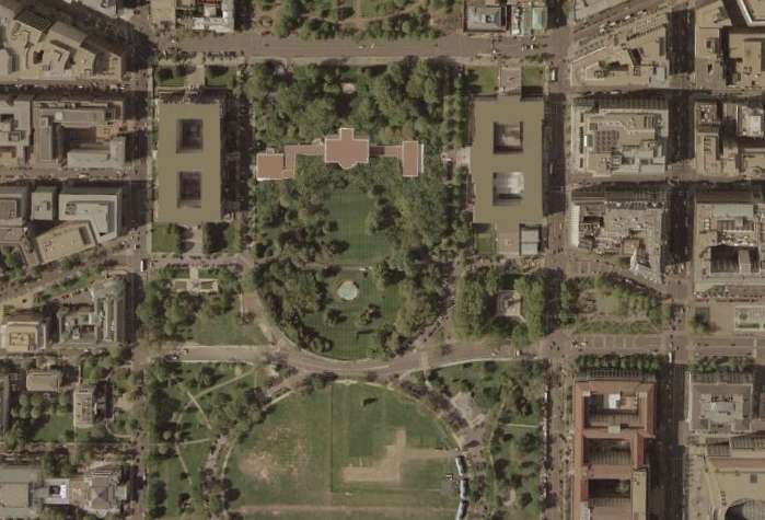
Come on guys, were not going to have another seagull/ufo thread are we? It's perfectly obvious the whitehouse images used to be heavily photoshopped
with extra trees and rooftops blanked out.
Even now I have no faith the current pictures are accurate of the roof tops.
Even now I have no faith the current pictures are accurate of the roof tops.
new topics
-
An Interesting Conversation with ChatGPT
Science & Technology: 4 hours ago
top topics
-
Have you noticed?? Post Election news coverage...
World War Three: 17 hours ago, 12 flags -
Squirrels becoming predators
Fragile Earth: 16 hours ago, 10 flags -
Drone Shooting Arrest - Walmart Involved
Mainstream News: 15 hours ago, 10 flags -
World's Best Christmas Lights!
General Chit Chat: 14 hours ago, 8 flags -
Can someone 'splain me like I'm 5. Blockchain?
Science & Technology: 15 hours ago, 7 flags -
Labour's Anti-Corruption Minister Named in Bangladesh Corruption Court Papers
Regional Politics: 17 hours ago, 6 flags -
An Interesting Conversation with ChatGPT
Science & Technology: 4 hours ago, 3 flags
active topics
-
An Interesting Conversation with ChatGPT
Science & Technology • 10 • : Flyingclaydisk -
Smartest Man in the World Tells His Theory About What Happens At Death
Philosophy and Metaphysics • 46 • : Naftalin -
Have you noticed?? Post Election news coverage...
World War Three • 9 • : ElitePlebeian2 -
World's Best Christmas Lights!
General Chit Chat • 12 • : GENERAL EYES -
The King James Bible, it's Translation, it's Preservation and its Inspiration
Religion, Faith, And Theology • 44 • : GENERAL EYES -
Drones everywhere in New Jersey ---and Elsewhere Master Thread
Aliens and UFOs • 201 • : worldstarcountry -
Drone Shooting Arrest - Walmart Involved
Mainstream News • 26 • : worldstarcountry -
Can someone 'splain me like I'm 5. Blockchain?
Science & Technology • 74 • : worldstarcountry -
Trump Meets Kristen Welker on Meet the Press
Mainstream News • 20 • : Astrocometus -
The Mystery Drones and Government Lies --- Master Thread
Political Conspiracies • 150 • : worldstarcountry
0