It looks like you're using an Ad Blocker.
Please white-list or disable AboveTopSecret.com in your ad-blocking tool.
Thank you.
Some features of ATS will be disabled while you continue to use an ad-blocker.
share:
No I havent. Its around Area 51, a couple of miles away. There are also buildings in the area.
Wow! maybe Israel has a secret base there and you discovered it? How big is this thing can you tell from the image? Looks like some underground
missile site to me. Maybe it is nuclear.
I'm pretty sure I've seen that picture and a discussion on it here
before, I think someone had an explanation for it, it certainly is
interesting , if I can find a link to it I will post it.
before, I think someone had an explanation for it, it certainly is
interesting , if I can find a link to it I will post it.
Alians huh? i'm with Conservative Man and think its a SAM sight and could be used for testing or maybe its active for defense
It reminds me of the Nasca lines, who knows what they're really using it for.
Originally posted by warpboost
Alians huh? i'm with Conservative Man and think its a SAM sight and could be used for testing or maybe its active for defense
My guess is that it's "fake" in the sense that it was created for the purpose of training, target practice, or testing, nothing more.
The Base Commander, Employees and Aliens are all Jewish
Its the Shield of David
Its the Shield of David
tried posting more pictures earlier but they didnt show up :/ My whole thing is why did they shape it like that; a circle with a star in it
Alright here are more coordinates of more things
(use in either Google Earth or maps.google.com:
37°37'42.19" N 116°50'54.66" W
37°40'09.27" N 116°01'31.90" W
[edit on 14-10-2006 by Aurora51]
[edit on 14-10-2006 by Aurora51]
Alright here are more coordinates of more things
(use in either Google Earth or maps.google.com:
37°37'42.19" N 116°50'54.66" W
37°40'09.27" N 116°01'31.90" W
[edit on 14-10-2006 by Aurora51]
[edit on 14-10-2006 by Aurora51]
Because the USSR often laid out their SA-2 Surface to air missiles like that. You can see how the surface in that location is scarred from the
impacts of the practice bombs, and you can even see a few individual craters too.
There is also a fake North Korean airfield nearby to that also.
There is also a fake North Korean airfield nearby to that also.
This has been discussed on ATS before. It is a simulated surface-to-air missile (SAM) site on the Nellis Air Force Range.
Heh, if this was'nt explained by the time I posted, i probebly would of went on thinking it had somethiing to do with aliens.
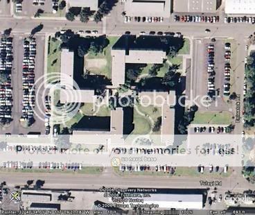
Sure its a SAM site, but why in the world do you not ask why it is shaped like the shield of David? These are the questions to ask. Like why is this
navy base building shaped like this? Do I have to tell you what that is?

Why is the pentagon the inside of a pentacle? Why is the Washington monument shaped as an Egyptian pagan Obelisk?
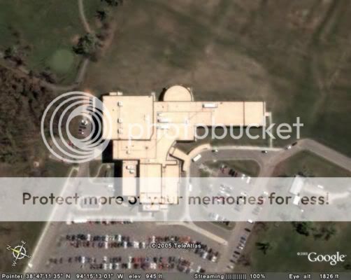
After all these school shootings, why is this school shaped like a gun?

I smell some black magick.

Why is the pentagon the inside of a pentacle? Why is the Washington monument shaped as an Egyptian pagan Obelisk?
After all these school shootings, why is this school shaped like a gun?

I smell some black magick.
Is it possible that the shapes of these buildings has an effect on the minds of the people inside them? Far out concept for sure. Maybe the architects
have a nasty sense of humour?
I found another one that's very strange. It has some very strange shapes and designs. It contains a 1.5 mile straight path. Anyone have any idea
where/what this place is?
37°24'20.62"N, 116°14'13.06"W

[edit on 16-10-2006 by DJMessiah]
37°24'20.62"N, 116°14'13.06"W

[edit on 16-10-2006 by DJMessiah]
Err, yeah, that "straight pathway" would be a runway. Hint: it's an airport.
What is the name of this airport? I've zoomed in with Google Earth, and the buildings are not actual buildings, but rather ridges:

Also, notice that the runway, and the structures around it are made of what seems to be dirt.

[edit on 16-10-2006 by DJMessiah]

Also, notice that the runway, and the structures around it are made of what seems to be dirt.

[edit on 16-10-2006 by DJMessiah]
new topics
-
Letters to the Editor: Altadena, my neighborhood, has burned. Make fossil-fuel companies pay
Propaganda Mill: 1 hours ago -
The LEGACY of Outgoing President JOSEPH R. BIDEN Jr. - Forced From Office Eff 1.20.2025.
US Political Madness: 1 hours ago -
UK and Europe Floods
Rant: 4 hours ago -
FEMA kicks hurricane survivors out of temporary housing into snowstorm and freezing temperatures
Disaster Conspiracies: 4 hours ago -
Failures of leadership on display
US Political Madness: 4 hours ago -
Power grid faults surged right before Los Angeles wildfires began
Mainstream News: 4 hours ago -
Tustin California Military equipment stolen BIG equipment .
Social Issues and Civil Unrest: 4 hours ago -
PALES-TINE, PALES-ADES and the Australian Aboriginal "Lightning Man"
Dreams & Predictions: 5 hours ago
top topics
-
FEMA kicks hurricane survivors out of temporary housing into snowstorm and freezing temperatures
Disaster Conspiracies: 4 hours ago, 15 flags -
Tustin California Military equipment stolen BIG equipment .
Social Issues and Civil Unrest: 4 hours ago, 14 flags -
Letters to the Editor: Altadena, my neighborhood, has burned. Make fossil-fuel companies pay
Propaganda Mill: 1 hours ago, 12 flags -
Failures of leadership on display
US Political Madness: 4 hours ago, 11 flags -
How To Spot Fake U.F.O. Photos
Aliens and UFOs: 16 hours ago, 8 flags -
Power grid faults surged right before Los Angeles wildfires began
Mainstream News: 4 hours ago, 7 flags -
UK and Europe Floods
Rant: 4 hours ago, 6 flags -
PALES-TINE, PALES-ADES and the Australian Aboriginal "Lightning Man"
Dreams & Predictions: 5 hours ago, 5 flags -
The LEGACY of Outgoing President JOSEPH R. BIDEN Jr. - Forced From Office Eff 1.20.2025.
US Political Madness: 1 hours ago, 5 flags
active topics
-
Trump says ownership of Greenland 'is an absolute necessity'
Other Current Events • 205 • : cherokeetroy -
Power grid faults surged right before Los Angeles wildfires began
Mainstream News • 11 • : fringeofthefringe -
The LEGACY of Outgoing President JOSEPH R. BIDEN Jr. - Forced From Office Eff 1.20.2025.
US Political Madness • 5 • : soulrevival -
Failures of leadership on display
US Political Madness • 11 • : Astrocometus -
Tustin California Military equipment stolen BIG equipment .
Social Issues and Civil Unrest • 14 • : hangedman13 -
Letters to the Editor: Altadena, my neighborhood, has burned. Make fossil-fuel companies pay
Propaganda Mill • 5 • : WeMustCare -
New UK Petition - Close the borders! Suspend ALL immigration for 5 years!
Regional Politics • 25 • : angelchemuel -
The Truth about Migrant Crime in Britain.
Social Issues and Civil Unrest • 51 • : Oldcarpy2 -
To become president, Zelensky had to learn Ukrainian
Political Conspiracies • 54 • : Oldcarpy2 -
This should be plastered all over the airwaves
Mainstream News • 60 • : awhispersecho
