It looks like you're using an Ad Blocker.
Please white-list or disable AboveTopSecret.com in your ad-blocking tool.
Thank you.
Some features of ATS will be disabled while you continue to use an ad-blocker.

The 9/11 Story in PICTURES, (esp. for media dumbed down dummies?).
page: 3share:
Additionally, and somewhat unrelated to my last post (thus the reason for a new post), I mentoned that I am familliar with the area. The photographs
of the Capitol Dome and Washington Monument jumping about it blatantly obvious different points of reference does scream to me that these photos
aren't as real as people claim them to be.
As was shown by a previous poster, the Washington Monument would be decidedly to the left of a head on shot of the burning wedge of the Pentagon. Also, considering that most of the photos are taken from a point to the left of the Pentagon, it would stand to reason that the Washington Monument would be even further to the left of the photo's viewpoint, likely not capturing the Monument at all. Additionally, the Capitol Building is East North East of the Pentagon, meaning that the Capitol Building would only show up in the views of the Pentagon wedge that was hit in the extreme right portions of the photos, if at all. If it did show up, the dome would appear very small (as it's about 3 miles away), and be likely virtually indistiguishable from the background.
That said, I can agree with the website author in saying that any photographs that show the Pentagon and the Washington Monument are likely fakes, at least in the background.
For comparison, I have included a highlighted image here:
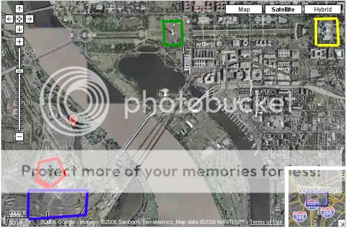
The Pentagon is highlighted in red, with the damaged side triple highlighted. 395, the road over which the plane flew to hit the Pentagon is highlighted in blue. The Washington Monument is highlighted in green, and the Capitol is highlighted in yellow.
Besides the colored boxes for the highlights, this image has not been altered at all from the original Google Maps image. Additionally, in the lower left corner, the scale can be seen (partially obscured by the blue box, but visible enough to give you an idea). As you can see, the scale denotes 2000 feet between the vertical marks. This gives a distance of roughly 1 mile between the Pentagon and the Washington Monument, and roughly 2-3 miles between the Pentagon and Capitol Building.
Please use this as a point of reference between the landmarks in question, while further evaluating the photographs outlined in the website.
As was shown by a previous poster, the Washington Monument would be decidedly to the left of a head on shot of the burning wedge of the Pentagon. Also, considering that most of the photos are taken from a point to the left of the Pentagon, it would stand to reason that the Washington Monument would be even further to the left of the photo's viewpoint, likely not capturing the Monument at all. Additionally, the Capitol Building is East North East of the Pentagon, meaning that the Capitol Building would only show up in the views of the Pentagon wedge that was hit in the extreme right portions of the photos, if at all. If it did show up, the dome would appear very small (as it's about 3 miles away), and be likely virtually indistiguishable from the background.
That said, I can agree with the website author in saying that any photographs that show the Pentagon and the Washington Monument are likely fakes, at least in the background.
For comparison, I have included a highlighted image here:
The Pentagon is highlighted in red, with the damaged side triple highlighted. 395, the road over which the plane flew to hit the Pentagon is highlighted in blue. The Washington Monument is highlighted in green, and the Capitol is highlighted in yellow.
Besides the colored boxes for the highlights, this image has not been altered at all from the original Google Maps image. Additionally, in the lower left corner, the scale can be seen (partially obscured by the blue box, but visible enough to give you an idea). As you can see, the scale denotes 2000 feet between the vertical marks. This gives a distance of roughly 1 mile between the Pentagon and the Washington Monument, and roughly 2-3 miles between the Pentagon and Capitol Building.
Please use this as a point of reference between the landmarks in question, while further evaluating the photographs outlined in the website.
I noticed from the satellite images when I looked them up that you can make a straight line from the Monument to the part of the facade allegedly hit
by a 757, and while the angle is somewhat sharp, I'm more inclined to believe that the angle is possible.
Like I said in an earlier post, though, I still don't understand why there are such vast differences between different photos I've found. The angles of the Pentagon in the two most contrasting images I used look to have been pretty damned close.
Ie, you can make this line of view:
And possibly get this:
But for this view:
Where would one be standing? I can place a photographer when s/he can get both in about the same positions, but then they'd be looking down that facade of the Pentagon from the opposite direction. Maybe it has something to do with the type of camera used?
Like I said in an earlier post, though, I still don't understand why there are such vast differences between different photos I've found. The angles of the Pentagon in the two most contrasting images I used look to have been pretty damned close.
I think I'm missing something inherent in 3D photos of the Pentagon and Washington Monument, but the news angles look possible from Google Maps. I still don't get what causes such great differences in the placement of the Monument given how far back it is, but nonetheless, Google Maps seems to show that at least the angles showing the Monument directly behind the impacted section would've been possible.
Ie, you can make this line of view:

And possibly get this:

But for this view:

Where would one be standing? I can place a photographer when s/he can get both in about the same positions, but then they'd be looking down that facade of the Pentagon from the opposite direction. Maybe it has something to do with the type of camera used?
those pictures could have been taken with special camera apertures, like a fish-eye lens, a wide angle lens, and the best bet is a combination of
those with an accordeon-shaped aperture, such that the lenses will make an angle to the camera body, thus making it possible to keep everything sharp,
from the near to the far distance and all inbetween.
This kind of aperture is used a lot by advertisement photographers, f.ex. to show a white sheet full of picnic utilencies, while the sloping background of an Alp meadow cushioned with multicolored flowers is fully sharp, including the mountains on the other side of the valley.
I'm composing a compilation of all known and unknown WTC 7 photo's on 9/11, to post it here.
Please feel free to post anything like that (or WTC or Pentagon or flight 93) in this thread, pictures explain a lot more than text alone.
I still have an aching feeling about the WTC 6 pictures from mr White.
The most compelling ones are the ones where you see the smoke been blown to the right of the top of the WTC 1, while in other LATER pictures that top smoke is clearly blowing to the left.
Especially clear to see in the sequence of 6 video stills I already described.
And ofcourse the same fuzzy big picture that Long Lance also described, with the small bit of smoke? seen in the lower right corner.
C:\Dokumente und Einstellungen\MAXI\Desktop\9-11 Photo's + Links\www.didik.com-wtc2.htm
First we need a map and the extension of the debris fields of the collapses :
Let's find one at this website : www.geocities.com...
which took it obviously from a NIST report.
NOTE please, the strange heavy (dark orange colored) debris fields extending (esp.) west- and eastwards for WTC 1.
The heavy debris fields to the north and south are however, equally spread out.
According to this map, heavy debris never reached the south facade of WTC 7.
QUESTION : a logical observation following out of the fact that WTC 1 has a pronounced westward extension of its heavy debris fields would be, that the top portion of that tower leaned first to the west and then toppled over to the west.
We may even conclude that the top breaking off was the longest one for WTC 1, since its debris reached to the exterior collumns of the WFC Winter Garden complex.
Same goes for WTC 2, there the most heavy debris felt to the east, so its top portion must have leaned first to the east and then toppled over to the east.
Can you proof this with actual events seen in pictures or videos?
Then we concentrate on the WTC 7 pictures during the day of 11 September 2001 :
First a special picture, because of the angle it was taken :
The following picture comes from this forum :
www.911truthseekers.org...
and is probably for the color green elevated, since the "identical" one under it, seems original.
Forum page title : Dr. Firmage of BYU doesn't address 9/11 Issues.
Probably taken after the second collapse, of the WTC 1, North Tower.
The corner edge damage on the WFC 3 building, with the Verizon building in the top background, is clearly to see.
No visible damage to see on the roof of the Winter Garden, (camera angle?).
A short video with lots of visible smoke behind WTC 7 can be found at the Loose Change 2nd Edition Viewer Guide site,
www.ccdominoes.com... :
The link to the video is :
911myths.com... ,and a still picture (bottom one) from this short video :
The above building to the left, the white one with the "step" in it and the few dark broken window holes, is the front West St. corner from the WFC 2 building. It doesn't have the extensive right corner damage, as we see in the first above picture. The corner in the first above picture is the right West St. front corner from the WFC 3 building, with the Verizon building (also known as the NY Telephone building) in the left background high behind it.
In the above last screenshot, the bottom right corner of the Verizon building is just to see as a white structure, and it's shadow falls on the opposite side of the Washington St. side of the WTC 7, under the 20th floor west windows.
One could recognise (with a lot of imagination) inside the heavy smoke in the 911myths.com... short video a dark gaping square hole in the middle of the south frontside of WTC 7, the side where some debris from the WTC 1, North Tower collapse, supposedly ripped away a substantial part of that south facade.
The interesting thing I see, is a flashing spot of light in the middle of that dark smoky hole, and while I do not believe that it is a reflection of the sun, since the side of the WFC 2 in the foreground is clearly not lighted by the sun, it still could be a reflection within very strict time parameters. That facade stands about 30° to the south facade of the WTC 7, so if it is the suns reflection, then we have a clear time span for the time of day that the video was taken. The west side of WTC 7 is full in the sun, while the south side is at the most sun-strifed .
My guess: somewhere around 17:00 hrs, since the north axis of Manhattan is nearly parallel with West Street, (In fact circa 7° off to the west) and the sun travels during the day from east to west.
Why all these words? Because one can observe in the video, that the factual smoke from WTC 7 is mixed at the bottom, around the 20th floor of WTC 7, with greyish-white smoke from the North Tower burning debris and WTC 5 and 6 burning debris.
Remember, the wind was blowing that day from a NNE direction. Thus it formed a vortex behind WTC 7's south front, which sucked a lot of smoke from the burning debris from WTC 5 and 6 and WTC 1 into it.
""Looking south from the 29th floor of 40 Harrison
Street, three blocks north of the former trade center."" ""7 World Trade Center, at about 2:30PM.""
""7 World Trade Center on fire""
""The very large, covered pedestrian foot bridge, over the
West Side Highway had collapsed onto the highway as a
result of being hit by debris from one of the Twin Towers.""
""1. Former WTC Twin Towers behind the building (LT:WTC 7).
2. Direction (LT:East side) of 7 World Trade Center.
3. The damaged, World Financial Center
4. The Collapsed Pedestrian foot bridge.""
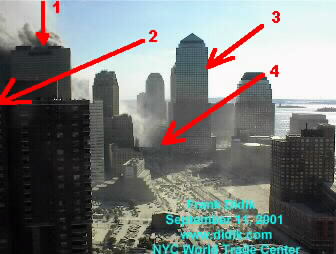
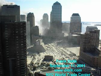
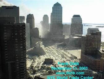
The second picture to the right (endstage of WTC 7 collapse) is for me the proof that all the
big smoke collumns we see in all the other pictures from WTC 7 during the day of 9/11 were
in fact mostly smoke from the burning and smoldering remnants and debris of WTC 5 and 6,
and WTC 1 and 2.
Because that same smoke collumn is still going skywards, while WTC 7 is totally collapsed.
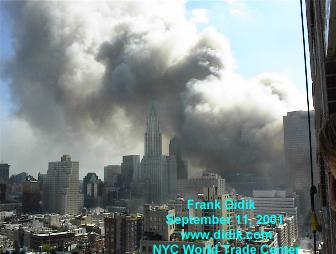
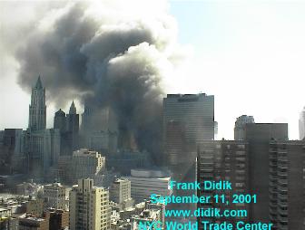
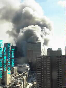
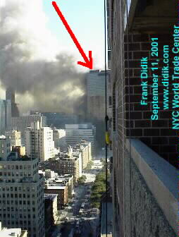
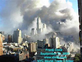
Only in the next Frank Didik picture you start to see the whitish smoke from the WTC 7 collapse rising skywards,
in front of that other smoke collumn. And the next picture shows that the factual collapse-smoke from WTC 7 is
quickly fading away, leaving the still huge smoke collumn of WTC 6+1.
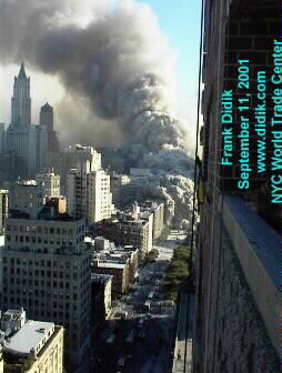
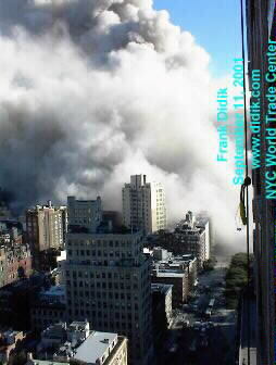
The Frank Didik pictures shown here are the nrs 18 to 31. There are another row of after collapse pictures at his site from 32 to 43.
You can get the hires pictures from Frank if you email him personally and give him a good reason to ask for them.
( His website : www.didik.com... )
This website tries to debunk a lot of non-official conspiracy material, while trying to proof the official conspiracy.
They bring up quite some good material, but do not realize the real big holes in the official story :
www.geocities.com...
They have a very good video from another debunking website, www.911myths.com... , of the south side of a burning WTC 7, but how convenient, that video is shot from such an angle, that it is impossible to see the "gaping hole" in the south facade. ( Video : www.911myths.com... )
One thing however is quite good to see. That the smoke coming in effect from the south facade of WTC 7, is just a small portion of all the smoke rising there.
And it doesn't look like a raging fire too. It more looks like some smoldering of office furniture on several floors, giving off a dark sooted smoke.
This next picture comes from another debunking website, www.ccdominoes.com... .
""Looking south towards ruins of WTC 6 and 1. WTC 7 is at left. Photographer is 200 meters from WTC 1.""
The aluminum cladding right in the foreground of this picture (looking south into Washington St.) is blown away from WTC 6 or WTC 1.
The debris in Washington St. seems to be mostly lightweight also. In the distance the crumpled south wall of WTC 6 can be seen.
This picture comes from 911research.wtc7.net .
911research.wtc7.net...
This looks like the WTC 7 side on West Broadway, the side opposite of the U.S. Post Office (Federal Building). The photographer stood then on Vesey St.
There is a strange movement of the smoke from the 7 burning windows, it moves to the north, instead of all the smoke at the south side which moves to the southeast. You also see the mix of very dark black smoke and a lot of white smoke going up from the windows adjacent to the last two burning windows. And the color of the south side smoke is brownish. Colors are subjective in all these pics, you never know exactly how the photographer set his camera settings.
911research.wtc7.net...
That huge crater in WTC 6 could have been caused by the hat truss of WTC 1. That was a damn heavy construction, made from very strong I beams, U beams and H beams, all welded and clamped together to a giant multiple tons construction to hold the outside walls together in connection with the inner core top collumns.
We see that all debris is square of nature and that hat truss was a square object too.
But how come then, that all the 8 visible WTC 6 craterholes are circular of nature?
I am really waiting for a logical explanation of all those round, deep crater-like holes in WTC 6.
Didn't found one on the web, up till now.
Exerpt from www.ccdominoes.com... :
The sentence from Lieutenant William Ryan : ""the smoke from all the other buildings on fire, you [couldn't] see anything"" makes it very clear, that the most substantial part of that smoke collumn rising from the south side of WTC 7 all day, was not from WTC 7, but from the other collapsed buildings behind it, which were ""burning like crazy."
I find it very strange that not ONE clear picture of the "officially declared" center damage in the south facade exists to this day.
The best positions for a good shot of that damage would have been from the heli's hoovering around all day.
A heli from the NYPD made that clear shot of the southwest corner damage (Verizon side) from above we know from 1 year ago,
and made hundreds of other detailed pictures from the damage to WTC 1 and 2, which were all publicized in the final reports from NIST, so it seems very arkward that the same heli's suddenly didn't have time anymore to concentrate on the remaining building in distress, the WTC 7.
I am sure that there are good pictures of the south facade of WTC 7, during the whole day of 9/11, and that those pictures are the reason why NIST is trying to outsource the last remaining report they must offer the public. The famous -final- WTC 7 report.
So they can lay the blame at a third party when the obvious holes in their theories will be explained.
What they have publicized up till now is based on a few "supposes", clearly gripped out of thin air, especially the socalled south front center damage drawing, (see for drawing, this page : www.geocities.com... ), where they draw a totally hypothetical deep hole, caused by WTC 1 (North Tower) debris, so as to be able to set up a theory of collapse, where they needed a few center collumns to be heavily damaged, to be able at all to explain a total building failure like we all saw happened that day of 9/11.
Just imagine the despair of these NIST researchers, to have to explain a perfect down on the footprint implosion, to be caused by solely front damage, at the smallest front of the building. The back front was a lot wider.
This should have caused a natural hinge-type collapse, resulting in a toppling over of WTC 7 southwards, over the debris of WTC 6 and WTC 1.
Especially since WTC 7 was so small (thin) from north-back to south-front, compared to its height and wide.
[edit on 11/7/06 by LaBTop]
First we need a map and the extension of the debris fields of the collapses :
Let's find one at this website : www.geocities.com...
which took it obviously from a NIST report.

NOTE please, the strange heavy (dark orange colored) debris fields extending (esp.) west- and eastwards for WTC 1.
The heavy debris fields to the north and south are however, equally spread out.
According to this map, heavy debris never reached the south facade of WTC 7.
QUESTION : a logical observation following out of the fact that WTC 1 has a pronounced westward extension of its heavy debris fields would be, that the top portion of that tower leaned first to the west and then toppled over to the west.
We may even conclude that the top breaking off was the longest one for WTC 1, since its debris reached to the exterior collumns of the WFC Winter Garden complex.
Same goes for WTC 2, there the most heavy debris felt to the east, so its top portion must have leaned first to the east and then toppled over to the east.
Can you proof this with actual events seen in pictures or videos?
Then we concentrate on the WTC 7 pictures during the day of 11 September 2001 :
First a special picture, because of the angle it was taken :

The following picture comes from this forum :
www.911truthseekers.org...
and is probably for the color green elevated, since the "identical" one under it, seems original.
Forum page title : Dr. Firmage of BYU doesn't address 9/11 Issues.
Probably taken after the second collapse, of the WTC 1, North Tower.
The corner edge damage on the WFC 3 building, with the Verizon building in the top background, is clearly to see.
No visible damage to see on the roof of the Winter Garden, (camera angle?).


A short video with lots of visible smoke behind WTC 7 can be found at the Loose Change 2nd Edition Viewer Guide site,
www.ccdominoes.com... :
The link to the video is :
911myths.com... ,and a still picture (bottom one) from this short video :

The above building to the left, the white one with the "step" in it and the few dark broken window holes, is the front West St. corner from the WFC 2 building. It doesn't have the extensive right corner damage, as we see in the first above picture. The corner in the first above picture is the right West St. front corner from the WFC 3 building, with the Verizon building (also known as the NY Telephone building) in the left background high behind it.
In the above last screenshot, the bottom right corner of the Verizon building is just to see as a white structure, and it's shadow falls on the opposite side of the Washington St. side of the WTC 7, under the 20th floor west windows.
One could recognise (with a lot of imagination) inside the heavy smoke in the 911myths.com... short video a dark gaping square hole in the middle of the south frontside of WTC 7, the side where some debris from the WTC 1, North Tower collapse, supposedly ripped away a substantial part of that south facade.
The interesting thing I see, is a flashing spot of light in the middle of that dark smoky hole, and while I do not believe that it is a reflection of the sun, since the side of the WFC 2 in the foreground is clearly not lighted by the sun, it still could be a reflection within very strict time parameters. That facade stands about 30° to the south facade of the WTC 7, so if it is the suns reflection, then we have a clear time span for the time of day that the video was taken. The west side of WTC 7 is full in the sun, while the south side is at the most sun-strifed .
My guess: somewhere around 17:00 hrs, since the north axis of Manhattan is nearly parallel with West Street, (In fact circa 7° off to the west) and the sun travels during the day from east to west.
Why all these words? Because one can observe in the video, that the factual smoke from WTC 7 is mixed at the bottom, around the 20th floor of WTC 7, with greyish-white smoke from the North Tower burning debris and WTC 5 and 6 burning debris.
Remember, the wind was blowing that day from a NNE direction. Thus it formed a vortex behind WTC 7's south front, which sucked a lot of smoke from the burning debris from WTC 5 and 6 and WTC 1 into it.
""Looking south from the 29th floor of 40 Harrison
Street, three blocks north of the former trade center."" ""7 World Trade Center, at about 2:30PM.""

""7 World Trade Center on fire""
""The very large, covered pedestrian foot bridge, over the
West Side Highway had collapsed onto the highway as a
result of being hit by debris from one of the Twin Towers.""

""1. Former WTC Twin Towers behind the building (LT:WTC 7).
2. Direction (LT:East side) of 7 World Trade Center.
3. The damaged, World Financial Center
4. The Collapsed Pedestrian foot bridge.""


The second picture to the right (endstage of WTC 7 collapse) is for me the proof that all the
big smoke collumns we see in all the other pictures from WTC 7 during the day of 9/11 were
in fact mostly smoke from the burning and smoldering remnants and debris of WTC 5 and 6,
and WTC 1 and 2.
Because that same smoke collumn is still going skywards, while WTC 7 is totally collapsed.
Only in the next Frank Didik picture you start to see the whitish smoke from the WTC 7 collapse rising skywards,
in front of that other smoke collumn. And the next picture shows that the factual collapse-smoke from WTC 7 is
quickly fading away, leaving the still huge smoke collumn of WTC 6+1.
The Frank Didik pictures shown here are the nrs 18 to 31. There are another row of after collapse pictures at his site from 32 to 43.
You can get the hires pictures from Frank if you email him personally and give him a good reason to ask for them.
( His website : www.didik.com... )
This website tries to debunk a lot of non-official conspiracy material, while trying to proof the official conspiracy.
They bring up quite some good material, but do not realize the real big holes in the official story :
www.geocities.com...
They have a very good video from another debunking website, www.911myths.com... , of the south side of a burning WTC 7, but how convenient, that video is shot from such an angle, that it is impossible to see the "gaping hole" in the south facade. ( Video : www.911myths.com... )
One thing however is quite good to see. That the smoke coming in effect from the south facade of WTC 7, is just a small portion of all the smoke rising there.
And it doesn't look like a raging fire too. It more looks like some smoldering of office furniture on several floors, giving off a dark sooted smoke.
This next picture comes from another debunking website, www.ccdominoes.com... .

""Looking south towards ruins of WTC 6 and 1. WTC 7 is at left. Photographer is 200 meters from WTC 1.""
The aluminum cladding right in the foreground of this picture (looking south into Washington St.) is blown away from WTC 6 or WTC 1.
The debris in Washington St. seems to be mostly lightweight also. In the distance the crumpled south wall of WTC 6 can be seen.
This picture comes from 911research.wtc7.net .
911research.wtc7.net...

This looks like the WTC 7 side on West Broadway, the side opposite of the U.S. Post Office (Federal Building). The photographer stood then on Vesey St.
There is a strange movement of the smoke from the 7 burning windows, it moves to the north, instead of all the smoke at the south side which moves to the southeast. You also see the mix of very dark black smoke and a lot of white smoke going up from the windows adjacent to the last two burning windows. And the color of the south side smoke is brownish. Colors are subjective in all these pics, you never know exactly how the photographer set his camera settings.
911research.wtc7.net...

That huge crater in WTC 6 could have been caused by the hat truss of WTC 1. That was a damn heavy construction, made from very strong I beams, U beams and H beams, all welded and clamped together to a giant multiple tons construction to hold the outside walls together in connection with the inner core top collumns.
We see that all debris is square of nature and that hat truss was a square object too.
But how come then, that all the 8 visible WTC 6 craterholes are circular of nature?
I am really waiting for a logical explanation of all those round, deep crater-like holes in WTC 6.
Didn't found one on the web, up till now.
Exerpt from www.ccdominoes.com... :
"Then we found out, I guess around 3:00 [o'clock], that they thought 7 was going to collapse. So, of course, [we've] got guys all in this pile over here and the main concern was get everybody out, and I guess it took us over an hour and a half, two hours to get everybody out of there. (Q. Initially when you were there, you had said you heard a few Maydays?) Oh, yes. We had Maydays like crazy.... The heat must have been tremendous. There was so much [expletive] fire there. This whole pile was burning like crazy. Just the heat and the smoke from all the other buildings on fire, you [couldn't] see anything. So it took us a while and we ended up backing everybody out, and [that's] when 7 collapsed.... Basically, we fell back for 7 to collapse, and then we waited a while and it got a lot more organized, I would guess." - Lieutenant William Ryan
The sentence from Lieutenant William Ryan : ""the smoke from all the other buildings on fire, you [couldn't] see anything"" makes it very clear, that the most substantial part of that smoke collumn rising from the south side of WTC 7 all day, was not from WTC 7, but from the other collapsed buildings behind it, which were ""burning like crazy."
I find it very strange that not ONE clear picture of the "officially declared" center damage in the south facade exists to this day.
The best positions for a good shot of that damage would have been from the heli's hoovering around all day.
A heli from the NYPD made that clear shot of the southwest corner damage (Verizon side) from above we know from 1 year ago,

and made hundreds of other detailed pictures from the damage to WTC 1 and 2, which were all publicized in the final reports from NIST, so it seems very arkward that the same heli's suddenly didn't have time anymore to concentrate on the remaining building in distress, the WTC 7.
I am sure that there are good pictures of the south facade of WTC 7, during the whole day of 9/11, and that those pictures are the reason why NIST is trying to outsource the last remaining report they must offer the public. The famous -final- WTC 7 report.
So they can lay the blame at a third party when the obvious holes in their theories will be explained.
What they have publicized up till now is based on a few "supposes", clearly gripped out of thin air, especially the socalled south front center damage drawing, (see for drawing, this page : www.geocities.com... ), where they draw a totally hypothetical deep hole, caused by WTC 1 (North Tower) debris, so as to be able to set up a theory of collapse, where they needed a few center collumns to be heavily damaged, to be able at all to explain a total building failure like we all saw happened that day of 9/11.
Just imagine the despair of these NIST researchers, to have to explain a perfect down on the footprint implosion, to be caused by solely front damage, at the smallest front of the building. The back front was a lot wider.
This should have caused a natural hinge-type collapse, resulting in a toppling over of WTC 7 southwards, over the debris of WTC 6 and WTC 1.
Especially since WTC 7 was so small (thin) from north-back to south-front, compared to its height and wide.
[edit on 11/7/06 by LaBTop]
new topics
-
Would Democrats Be in Better Shape if They Had Replaced Joe Biden with Kamala Harris in July 2024.
US Political Madness: 4 hours ago -
President Biden is Touring Africa. Why?
Politicians & People: 8 hours ago -
CIA Whistleblower Kevin Shipp claims CIA was involved in MH370's disappearance
General Conspiracies: 8 hours ago -
US spent $151 BILLION on illegal immigration in 2023 alone: DOGE
US Political Madness: 8 hours ago -
Liven things up with some COMMUNITY!
General Chit Chat: 9 hours ago -
Russian Disinformation Campaign Claims Stalker 2 Is Used To Locate Ukraine War Conscripts
Mainstream News: 11 hours ago
top topics
-
It's time to dissect the LAWFARE
Dissecting Disinformation: 12 hours ago, 11 flags -
Happy Birthday OZZY
Music: 15 hours ago, 9 flags -
Liven things up with some COMMUNITY!
General Chit Chat: 9 hours ago, 8 flags -
US spent $151 BILLION on illegal immigration in 2023 alone: DOGE
US Political Madness: 8 hours ago, 6 flags -
Chinese national busted in LA sending weapons to NK
World War Three: 16 hours ago, 5 flags -
CIA Whistleblower Kevin Shipp claims CIA was involved in MH370's disappearance
General Conspiracies: 8 hours ago, 4 flags -
President Biden is Touring Africa. Why?
Politicians & People: 8 hours ago, 4 flags -
Russian Disinformation Campaign Claims Stalker 2 Is Used To Locate Ukraine War Conscripts
Mainstream News: 11 hours ago, 2 flags -
Would Democrats Be in Better Shape if They Had Replaced Joe Biden with Kamala Harris in July 2024.
US Political Madness: 4 hours ago, 1 flags