It looks like you're using an Ad Blocker.
Please white-list or disable AboveTopSecret.com in your ad-blocking tool.
Thank you.
Some features of ATS will be disabled while you continue to use an ad-blocker.

Tropical Storm Beta
page: 10
share:
Hi All,
Well, as predicted hurricane season is far from over, and to prove it we now have tropcal storm Beta. Here are a few brief reports:
From Accuweather
From
NHC
I also see a few more tropical waves behind Beta that look pretty active.
[EDIT: I also read NHC's 5 am discussion and they believe that Beta could develope into a hurricane before landfall. ]
[edit on 10/27/2005 by sylvrshadow]
Well, as predicted hurricane season is far from over, and to prove it we now have tropcal storm Beta. Here are a few brief reports:
From Accuweather
TROPICAL STORM BETA FORMS IN THE SOUTHWESTERN CARIBBEAN
At 5 a.m. Thursday, Tropical Depression 26 became Tropical Storm Beta, the 23rd tropical storm of the 2005 Atlantic season. The storm was located near 11.4 north and 81.8 west, or about 140 miles east-southeast of Bluefields, Nicaragua and 75 miles south of San Andres Island. It is slowly moving toward the northwest near 5 mph and has sustained winds near 40 mph. Estimated central pressure is 1005 millibars or 29.68 inches.
A hurricane watch and tropical storm warning are in effect for the islands of San Andres and Providencia. A tropical storm warning is also in effect for the entire Caribbean coast of Nicaragua from the border with Costa Rica to the Honduras border, as well as the adjacent islands.
From
NHC
8 AM EDT THU OCT 27 2005
...BETA MOVING SLOWLY NORTHWESTWARD OVER THE SOUTHWESTERN CARIBBEAN SEA...VERY HEAVY RAINFALL EXPECTED IN PORTIONS OF CENTRAL
AMERICA...
AT 8 AM EDT...1200Z...THE CENTER OF TROPICAL STORM BETA WAS LOCATED
NEAR LATITUDE 11.5 NORTH... LONGITUDE 81.8 WEST OR ABOUT 70
MILES... 115 KM... SOUTH OF SAN ANDRES ISLAND AND ABOUT 135
MILES... 220 KM...EAST-SOUTHEAST OF BLUEFIELDS NICARAGUA.
BETA IS MOVING GENERALLY TOWARD THE NORTHWEST NEAR 4 MPH... 6
KM/HR... AND THIS GENERAL MOTION IS EXPECTED TO CONTINUE DURING THE
NEXT 24 HOURS.
MAXIMUM SUSTAINED WINDS ARE NEAR 40 MPH... 65 KM/HR...WITH HIGHER
GUSTS. SOME STRENGTHENING IS FORECAST DURING THE NEXT 24 HOURS.
TROPICAL STORM FORCE WINDS EXTEND OUTWARD UP TO 35 MILES... 55 KM
FROM THE CENTER.
ESTIMATED MINIMUM CENTRAL PRESSURE IS 1005 MB...29.68 INCHES.
I also see a few more tropical waves behind Beta that look pretty active.
[EDIT: I also read NHC's 5 am discussion and they believe that Beta could develope into a hurricane before landfall. ]
[edit on 10/27/2005 by sylvrshadow]
If the moon was hovering over it like around the 20th of Sep and Oct, then we'd probably have a giant hurricane. Wait till around the 20th of Nov,
Hurricane Gamma will whoop ass.
Hi all
Just a quick update on Beta:
(From Accuweather )
They are still expecting some strengthening before landfall.
The way things have been lately PizzaCrust, I wuldnt be surprised.
Just a quick update on Beta:
At 11 a.m. Thursday, Tropical Storm Beta, the 23rd tropical storm of the 2005 Atlantic season, was located near 11.5 north and 81.3 west, or about 175 miles east of Bluefields, Nicaragua and 75 miles south-southeast of San Andres Island. Beta is drifting o the north and this is expected to continue over the next day or so. Maximum sustained winds are near 50 mph. Estimated central pressure is 1000 millibars or 29.53 inches.
(From Accuweather )
They are still expecting some strengthening before landfall.
If the moon was hovering over it like around the 20th of Sep and Oct, then we'd probably have a giant hurricane. Wait till around the 20th of Nov, Hurricane Gamma will whoop ass.
The way things have been lately PizzaCrust, I wuldnt be surprised.
I'm not seeing anything on the weather channel about it. Are they not considering it a threat?
Nevermind, they are covering it now.
Troy
[edit on 27-10-2005 by cybertroy]
Nevermind, they are covering it now.
Troy
[edit on 27-10-2005 by cybertroy]
Hi All,
Here is a quick update on TS Beta.
From NHC
This is Accuweaters prediction of the storms path and intensity.
This is a short blurb from Dr Jeff Masters Blog on Weather Underground:
It is definitely looking more organized in the satalite images.
[edit on 10/27/2005 by sylvrshadow]
Here is a quick update on TS Beta.
From NHC
2 PM EDT THU OCT 27 2005
...CORRECT PRESSURE IN REPEAT SECTION...
...TROPICAL STORM BETA STRENGTHENING AND RE-LOCATED EASTWARD...NEW
WARNINGS AND WATCHES ISSUED...
AT 2 PM EDT...1800Z...THE CENTER OF TROPICAL STORM BETA WAS
LOCATED NEAR LATITUDE 11.6 NORTH...LONGITUDE 81.4 WEST OR ABOUT 70
MILES... 115 KM...SOUTH-SOUTHEAST OF SAN ANDRES ISLAND AND ABOUT
160 MILES... 260 KM...EAST OF BLUEFIELDS NICARAGUA.
BETA IS DRIFTING TOWARD THE NORTH. A SLOW NORTHWARD MOTION IS
EXPECTED DURING THE NEXT 24 HOURS. THIS MOTION COULD BRING THE
CENTER OF BETA NEAR SAN ANDRES ON FRIDAY.
MAXIMUM SUSTAINED WINDS ARE NEAR 60 MPH... 95 KM/HR...WITH HIGHER
GUSTS. STRENGTHENING IS FORECAST DURING THE NEXT 24 HOURS...AND
BETA COULD BECOME A HURRICANE LATE TONIGHT OR FRIDAY.
TROPICAL STORM FORCE WINDS EXTEND OUTWARD UP TO 60 MILES
... 95 KM FROM THE CENTER.
ESTIMATED MINIMUM CENTRAL PRESSURE IS 997 MB...29.44 INCHES.
This is Accuweaters prediction of the storms path and intensity.
This is a short blurb from Dr Jeff Masters Blog on Weather Underground:
The Hurricane Season of 2005 remains unrelenting. Tropical Storm Beta formed this morning over the warm ocean waters of the southwest Caribbean, just north of Panama. Given the ideal environment for intensification setting up in the southwest Caribbean, this is likely to become Hurricane Beta by tonight, and could grow to major hurricane status before making landfall in Nicaragua on Sunday.
Recent satellite imagery shows a small but rapidly developing system. There is plenty of growing deep convection, good low-level spiral banding, and a Central Dense Overcast (CDO) forming over the center. An eyewall appears to be forming under the CDO, and there is a good chance we'll be talking about Hurricane Beta by this evening
It is definitely looking more organized in the satalite images.
[edit on 10/27/2005 by sylvrshadow]
Did anyone notice that beta is forming in almost the exact same spot as wilma?
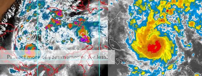
Take a guess as to which storm is which
wilma is on the right, but the current radar is showing that infamous pinpoint eye in certain frames.
what are the ocean temps this time around?
Take a guess as to which storm is which
wilma is on the right, but the current radar is showing that infamous pinpoint eye in certain frames.
what are the ocean temps this time around?
Si it looks like it can strengthen to cat-2 and slam into Central America. What happens if it misses and continues northward? More strengthening? Same
track as Alpha?
Hi All,
Toxic Fox based on computer models, the meteorologists predict a straight path through Nicaragua. Sometimes the models are off, but I think because this storm is so close to land, it will not devivate far from the projected path. This is just my guess though. This hurricane season has been anything but normal and has been full of surprises.
Toxic Fox based on computer models, the meteorologists predict a straight path through Nicaragua. Sometimes the models are off, but I think because this storm is so close to land, it will not devivate far from the projected path. This is just my guess though. This hurricane season has been anything but normal and has been full of surprises.
Hi All,
Just another quick uptdate on TS Beta.
This one is from Accuweather
Here is the latest from NHC
Just another quick uptdate on TS Beta.
This one is from Accuweather
At 8 p.m. Thursday, Tropical Storm Beta, the 23rd tropical storm of the 2005 Atlantic season, was located near 11.9 north and 81.4 west, or about 160 miles east of Bluefields, Nicaragua and 50 miles south-southeast of San Andres Island. Beta is drifting o the north and this is expected to continue over the next day or so. Maximum sustained winds are near 60 mph. Estimated central pressure is 997 millibars or 29.4 inches.
Here is the latest from NHC
8 PM EDT THU OCT 27 2005
...BETA CREEPING NORTHWARD...EXPECTED TO BECOME A HURRICANE LATER
TONIGHT OR FRIDAY.
A HURRICANE WARNING REMAINS IN EFFECT FOR THE ISLANDS OF SAN ANDRES AND PROVIDENCIA.
BETA IS DRIFTING NORTHWARD NEAR 3 MPH...6 KM/HR. A SLOW NORTHWARD TO
NORTH-NORTHWESTWARD MOTION IS EXPECTED DURING THE NEXT 24 HOURS.
THIS MOTION SHOULD BRING THE CENTER OF BETA NEAR SAN ANDRES LATE
TONIGHT OR FRIDAY.
MAXIMUM SUSTAINED WINDS REMAIN NEAR 60 MPH... 95 KM/HR...WITH HIGHER
GUSTS. STRENGTHENING IS FORECAST DURING THE NEXT 24 HOURS...AND
BETA IS EXPECTED TO BECOME A HURRICANE LATER TONIGHT OR ON FRIDAY.
TROPICAL STORM FORCE WINDS EXTEND OUTWARD UP TO 60 MILES... 95 KM
FROM THE CENTER MAINLY TO THE EAST OF THE CENTER.
Hi All,
Sorry for the lack of an update. Here is a quick one from www.weatherunderground.com
Here is a prediction from www.accuweather.com about Beta's future path. Interesting to day the least.
Sorry for the lack of an update. Here is a quick one from www.weatherunderground.com
At 8 PM EDT...0000z...the center of Tropical Storm Beta was
estimated near latitude 13.4 north...longitude 81.3 west...near or
over the island of Providencia. This is also about 155 miles...
250 km...east-southeast of Puerto Cabezas Nicaragua.
Beta is moving between the north-northwest and north near 5 mph...7
km/hr. A turn toward the northwest is expected during the next 24
hours. On this motion...the center of Beta will continue to be
near or over the island of Providencia for a few more hours.
Maximum sustained winds remain near 65 mph...100 km/hr...with higher
gusts. Strengthening is forecast during the next 24 hours...and
Beta could become a hurricane later tonight or on Saturday.
Here is a prediction from www.accuweather.com about Beta's future path. Interesting to day the least.
There is no basic change in the thinking from earlier this afternoon. An upper-level ridge of high pressure is nearby venting the storm, which puts it in an area favorable for gradual intensification. Beta has not intensified as much as expected due to some weak shear and it slow movement. The water temperatures under Beta are warm but the depth of this warm water is not that deep. So, the slow movement of the storm might be having some affect on its ability to strengthen. The current thinking is that pressures are still falling in the storm and it will be just a matter of time before the storm becomes a hurricane. We still believe there is time for Beta to become a Category 2 strength (96-110 mph) before making landfall in Nicaragua sometime Sunday.
An upper-level trough of low pressure will slowly pass across the Gulf of Mexico over the next day or so and should draw Beta slowly more north than west; a track more to the west is likely over the weekend as the trough moves into the Atlantic and high pressure in the mid-levels of the atmosphere builds westward across the Gulf of Mexico and northern Caribbean. However, if Beta gets too far north and west it might find a weakness on the west side of this upper level high which would allow Beta to move northwest and perhaps north next week. This could bring either the remnant circulation and or the rich moisture from Beta northeast towards Cuba. There is some chance this moisture and perhaps remnant circulation could come close to south Florida around Thursday of next week as another strong upper level trough picks up what is left of Beta (storm or remnant low).
I'm just wondering how far into the Greek alphabet we're going to go. What would happen after Omega--the last letter? Cyrillic?
2005 has been quite a year, methinks....
2005 has been quite a year, methinks....
BTW folks, it's HURRICANE BETA now here's an exerpt from the latest discussion.........
"conventional and microwave satellite imagery indicate Beta has
become much better organized during the past 6 hours and has
strengthened into the 13th hurricane of the 2005 Atlantic season. A
29/0211z SSMI overpass that was not available for the previous
advisory revealed a very small eye embedded within the strongest
convection... which means Beta was probably a hurricane at 00z. The
current intensity of 70 kt is a blend of Dvorak satellite intensity
estimates of t4.5/77 kt from TAFB and t4.0/65 kt from SAB."
Hi All,
Its update time!
This is from Accuweather
This update is from NHC
Accuweathers predicted path remains the same. Here also is a news story that I found on Yahoo News called Hurric ane Beta Heads for Carribean Coast
(By that they mean the Nicaraguan coastline)
Its update time!
This is from Accuweather
As of 7:00 p.m. CDT Saturday, Hurricane Beta was centered near 13.8 north and 82.6 west, or 90 miles south southeast of the coast at the Nicaragua/Honduras border. Beta is moving slowly to the west at about 5 mph with maximum sustained winds now near 90 mph and gusts to 110 mph. The estimated minimum central pressure is 979 millibars, or 28.91 inches.
This update is from NHC
8 PM EDT SAT OCT 29 2005
...CORE OF BETA GRADUALLY NEARING THE EAST COAST OF NICARAGUA...
WEATHER EXPECTED TO WORSEN...
BETA IS MOVING TOWARD THE WEST NEAR 5 MPH...7 KM/HR...AND THIS
GENERAL MOTION IS EXPECTED TO CONTINUE FOR THE NEXT 24 HOURS. THIS
MOTION SHOULD BRING THE CORE OF HURRICANE BETA NEAR THE NORTHEASTERN
COAST OF NICARAGUA AND THE NEARBY ISLANDS LATE TONIGHT OR EARLY
SUNDAY.
MAXIMUM SUSTAINED WINDS ARE NEAR 90 MPH...150 KM/HR...WITH HIGHER
GUSTS. BETA IS A CATEGORY ONE HURRICANE ON THE SAFFIR-SIMPSON
SCALE. ADDITIONAL STRENGTHENING IS FORECAST BEFORE LANDFALL IN
NICARAGUA. BETA IS EXPECTED TO BECOME A CATEGORY TWO HURRICANE...
AND THERE IS A CHANCE IT COULD BECOME A CATEGORY THREE MAJOR
HURRICANE.
HURRICANE FORCE WINDS EXTEND OUTWARD UP TO 15 MILES... 30 KM...
FROM THE CENTER...AND TROPICAL STORM FORCE WINDS EXTEND OUTWARD UP
TO 60 MILES... 95 KM.
THE ESTIMATED MINIMUM CENTRAL PRESSURE IS 979 MB...28.91 INCHES.
STORM SURGE FLOODING OF 10 TO 15 FEET ABOVE NORMAL TIDE LEVELS IS
POSSIBLE ALONG THE EASTERN COAST OF NICARAGUA NEAR AND TO THE NORTH
OF WHERE THE CENTER MAKES LANDFALL. STORM SURGE FLOODING ON
PROVIDENCIA SHOULD GRADUALLY SUBSIDE TONIGHT AS THE CENTER OF BETA
MOVES AWAY.
HURRICANE BETA IS EXPECTED TO PRODUCE TORRENTIAL RAINFALL WITH
TOTALS OF 10 TO 15 INCHES ACROSS NORTHEASTERN HONDURAS...NICARAGUA
...SAN ANDRES...AND PROVIDENCIA...WITH ISOLATED MAXIMUM AMOUNTS OF
25 INCHES POSSIBLE.
Accuweathers predicted path remains the same. Here also is a news story that I found on Yahoo News called Hurric ane Beta Heads for Carribean Coast
(By that they mean the Nicaraguan coastline)
Hi All,
Here is a update on hurricane beta. This is from accuweather
Here is a update on hurricane beta. This is from accuweather
BETA MAKES LANDFALL ON THE COAST OF NICARAGUA AS A CATEGORY 2 HURRICANE
As of 9:00 a.m. CDT Sunday, Hurricane Beta was centered near 12.7 north and 83.8 west, or on the coast of Nicaragua just inland from La Barra. This is also about 50 miles north of Bluefields, Nicaragua. Beta is moving slowly to the southwest at about 7 mph. Beta has weakened with maximum sustained winds of 90 mph. This makes Beta a Category 1 hurricane. Earlier today Beta peaked in intensity as a Category 3, or major hurricane, on the Saffir-Simpson Scale. The estimated minimum central pressure was 980 millibars, or 28.94 inches of mercury.
Hi All,
Here is a quick update on Beta, whic is now a Tropical Depression.
From Accuweather
Here is a news story from CNN called
Hurricane Beta belts Nicaragua
The good news is that there were no deaths reported.
Here is a quick update on Beta, whic is now a Tropical Depression.
From Accuweather
Today's Discussion Posted: October 31, 2005 6:15 a.m.
The remnants of Hurricane Beta will continue to dissipate over Central
America Monday. Heavy, flooding rains will occur over parts of western Nicaragua and Honduras, as well as El Salvador and southern Guatemala. The center of circulation remaining from Beta should move into the Pacific Ocean later Monday, probably near southern El Salvador. There is a slight chance that this system could reintensify over the eastern Pacific, and perhaps even climb back to hurricane status.
Here is a news story from CNN called
Hurricane Beta belts Nicaragua
The good news is that there were no deaths reported.
new topics
-
How we've changed in 100 years
Ancient & Lost Civilizations: 42 minutes ago -
US disburses $3.4 billion in budget aid for Ukraine, Yellen says
US Political Madness: 1 hours ago -
Nigel Farage's New Year Message.
Politicians & People: 3 hours ago -
I dont understand what i just witnessed
Social Issues and Civil Unrest: 4 hours ago -
The Silent Motion…
Short Stories: 7 hours ago -
Happy New Year from Aussie
General Chit Chat: 7 hours ago -
House republicans prove to be drama queens
US Political Madness: 8 hours ago
top topics
-
The C.D.C. Says There Was NO INFLUENZA Worth Reporting for the 2020-2021 Flu Season.
Diseases and Pandemics: 16 hours ago, 12 flags -
Strange fog all over the northern hemisphere
General Conspiracies: 15 hours ago, 12 flags -
I dont understand what i just witnessed
Social Issues and Civil Unrest: 4 hours ago, 9 flags -
Happy New Year from Aussie
General Chit Chat: 7 hours ago, 7 flags -
Nigel Farage's New Year Message.
Politicians & People: 3 hours ago, 6 flags -
House republicans prove to be drama queens
US Political Madness: 8 hours ago, 5 flags -
The Silent Motion…
Short Stories: 7 hours ago, 5 flags -
US disburses $3.4 billion in budget aid for Ukraine, Yellen says
US Political Madness: 1 hours ago, 5 flags -
How we've changed in 100 years
Ancient & Lost Civilizations: 42 minutes ago, 2 flags
active topics
-
How we've changed in 100 years
Ancient & Lost Civilizations • 3 • : alldaylong -
New World Order Coming?
New World Order • 28 • : BernnieJGato -
The C.D.C. Says There Was NO INFLUENZA Worth Reporting for the 2020-2021 Flu Season.
Diseases and Pandemics • 48 • : boatguy12 -
US disburses $3.4 billion in budget aid for Ukraine, Yellen says
US Political Madness • 9 • : hangedman13 -
-@TH3WH17ERABB17- -Q- ---TIME TO SHOW THE WORLD--- -Part- --44--
Dissecting Disinformation • 3870 • : Thoughtful3 -
Meta Llama local AI system is scary good
Science & Technology • 34 • : hoobah -
Elon Musk futurist?
Dreams & Predictions • 33 • : fringeofthefringe -
Do I post here or Cryptozoology.
Ancient & Lost Civilizations • 9 • : Solvedit -
Nigel Farage's New Year Message.
Politicians & People • 12 • : angelchemuel -
2 Guys die hunting Bigfoot
Cryptozoology • 25 • : dave5426
0