It looks like you're using an Ad Blocker.
Please white-list or disable AboveTopSecret.com in your ad-blocking tool.
Thank you.
Some features of ATS will be disabled while you continue to use an ad-blocker.
share:
Mizar
Your house looks exactly like the one I had in Sliddel last year. We moved to Corpus last January, but I still have lots of friends there. Can't get ahold of any, so hopefully they've already evaced.
My prayers are with you
Your house looks exactly like the one I had in Sliddel last year. We moved to Corpus last January, but I still have lots of friends there. Can't get ahold of any, so hopefully they've already evaced.
My prayers are with you
This is a map of Jefferson Parrish where Mizar is, maybe he can pinpoint his exact location for us
www.jeffparish.net...
Ladylily is in Covington which is in Saint Tammany Parish north of the lake.
www.epodunk.com...
we havent' heard from LadyLily in a while, I hope she has evacuated or is preparing for the worst right now.
[edit on 8-28-2005 by worldwatcher]
www.jeffparish.net...
Ladylily is in Covington which is in Saint Tammany Parish north of the lake.
www.epodunk.com...
we havent' heard from LadyLily in a while, I hope she has evacuated or is preparing for the worst right now.
[edit on 8-28-2005 by worldwatcher]
I would not want to be anywhere downtown right now. The Dome is a good place but.... Its basically like a big cage. I've been there numerous times.
IF the water levels get to where they predict they will be downtown then all teh lower levels of the dome are unexcessable. And I hope to God they
aren't puting anyone on the floor. Im 90% sure the floor is below the surface liek they dug a pit to have more seating and put the feild/ floor below
ground level. The only way for people to get out would be through the parking garage then the only way out would be by helocopter on the helipad. The
dome and anywhere downtown is a bad idea. Anywhere on the East bank is bad.
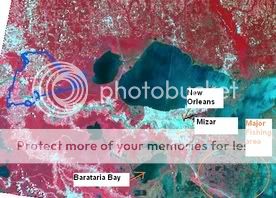
Whats going to happen is the storm surge is going to over flow Lake Pontrarain and the east bank is going to get flooded with loads of water then on the east bank all of the fishing watter ways are going to surge also..
THe big lake to the top is Lake PNntratrain. Even in cat 1 storms the surge over flows. Now that water in that lake is going to flow on the city... the Grey parts to teh north of the river. South of teh river has problems too.
That big lake thats south of the river is barataria bay. That area is a major fisshing area. its so sparse with land farther south. ANyway that water is goign to surge on the lower parts of the west bank, like Laifitte, bellechase, Plaqumens parish, Boothville. ANd if your on grand Isle.. well it will no longer exist...
now my location is quite intresting....
The lake water will not get to me because of the Mississippi river.. Also my part of town right there is an actual bulge that is about 6 feet above sea level. Now the water comming up for Baratria Bay wont reach me either becasue of distance and the volume of water.

That "major fissing area" will be completly under water most likely.
Whats going to happen is the storm surge is going to over flow Lake Pontrarain and the east bank is going to get flooded with loads of water then on the east bank all of the fishing watter ways are going to surge also..
THe big lake to the top is Lake PNntratrain. Even in cat 1 storms the surge over flows. Now that water in that lake is going to flow on the city... the Grey parts to teh north of the river. South of teh river has problems too.
That big lake thats south of the river is barataria bay. That area is a major fisshing area. its so sparse with land farther south. ANyway that water is goign to surge on the lower parts of the west bank, like Laifitte, bellechase, Plaqumens parish, Boothville. ANd if your on grand Isle.. well it will no longer exist...
now my location is quite intresting....
The lake water will not get to me because of the Mississippi river.. Also my part of town right there is an actual bulge that is about 6 feet above sea level. Now the water comming up for Baratria Bay wont reach me either becasue of distance and the volume of water.

That "major fissing area" will be completly under water most likely.
OK my Paint picture came out perty bad... oh well. In worldwatchers picture of teh parish I am under the "R" in marrero.
Whats a website I can host VIDs off? I can take liek 30 second clips with my digi camera.
Too those staying I hate to sound morbid but please do yourself the favor of at least writing out a letter to your family. In the rare event you dont
make it the letter can mean a lot. I really hate to sound so bad but this storm is going to make last years hurricanes look like nothing.
Be safe and please!!! KEEP US POSTED!!!
Be safe and please!!! KEEP US POSTED!!!
Mizar, thanks for the pics too
We do not know echoder, but I have been reading your posts for a while and feel close to you... Please, take care. We will be worried for you and your relatives.
A location map would be excellent if you can.
We will be thinking on you the whole night.
Sorry for not being able to leave on time, but I accept your decision, even though I feel sad for you not knowing what will happen.
Keep safe,
In a strange twist... with the pressure down to 902mb the winds have come down to 165mph. I suspect this is a temporary fluctuation in wind speed.
The storm is still very healthy.
I think the 165mph sustained winds is just a fluctuation, the pressure is 902mb, the wind will catch up with the pressure soon enough.
Usually a pressure fall is followed by a wind increase. The decrease of wind as you said is likely temporary. Wind gusts well over 200mph will more
than likely be felt when Katrina makes landfall.
I posted this in the other thread and I know I am not supposed to cross post but I will accept a warn because I feel this is important to note as it
is not something I had thought about before hearing this on the news and some people may not be reading both threads.......
Right now on the news they are talking about the fact that NO will be under water for weeks if this continues on the same course -- bringing up the concern that there will be coffins floating around also - so in addition to mold, mosquitos, chemicals in the water you have a concern of diseases from bodies floating around.
That isn't something I had thought about.
They are saying they may need to set up a refugee camp north of the city for millions of people for months while they are trying to clean up -- the CDC is involved in this already
SERIOUSLY SCARY!!
I think the temporary fluctuation is done. Here is the latest IR image and the bright red has wrapped completely around the eye again. She looks
perfect just like she did when she hit 175mph.
www.climatepatrol.com...
www.climatepatrol.com...
Originally posted by UM_Gazz
It looks like the storm may be turning more toward the north near the end of this loop:
The latest news I heard is it's track is heading more to the west, which means even worse news for New Orleans...the city could actually be leveled by this storm.
mizar......if i were you i'd have a nice bottle of BOOKERS bourbon on hand. it's 126 proof and even comes in a wooden box [so it floats better].
hope you know what you're doing down there.
Originally posted by worldwatcher
UMGAZZ
WARNING: To Everyone living well inland, in states such as Oklahoma, Arkansas, Georgia, The Carolinas, Tenessee and Kentucky, please keep your eye on Katrina. You will be affected. .
Wow, just last night I posted how nothing like this ever happens around here, I live in Arkansas.
Me and my big mouth.
Still, this is a good thread. Keeps you on the edge of your seat.
Wupy
new topics
-
A Merry Christmas.
Other Current Events: 2 hours ago -
Cold Blooded Killers on Christmas!! GRRRRrrr!!
Pets: 9 hours ago
top topics
-
Cold Blooded Killers on Christmas!! GRRRRrrr!!
Pets: 9 hours ago, 9 flags -
Plane Crash Today --Azerbaijanian E190 passenger jet
Mainstream News: 13 hours ago, 6 flags -
A Merry Christmas.
Other Current Events: 2 hours ago, 1 flags
active topics
-
Mood Music Part VI
Music • 3765 • : BrucellaOrchitis -
It's Offical Now
US Political Madness • 17 • : Freeborn -
‘Something horrible’: Somerset pit reveals bronze age cannibalism
Ancient & Lost Civilizations • 23 • : BrucellaOrchitis -
A Merry Christmas.
Other Current Events • 3 • : Cloudbuster1 -
Plane Crash Today --Azerbaijanian E190 passenger jet
Mainstream News • 17 • : Naftalin -
London Christmas Market BANS Word ‘Christmas’
Social Issues and Civil Unrest • 51 • : Naftalin -
-@TH3WH17ERABB17- -Q- ---TIME TO SHOW THE WORLD--- -Part- --44--
Dissecting Disinformation • 3814 • : brewtiger123 -
Cold Blooded Killers on Christmas!! GRRRRrrr!!
Pets • 10 • : Flyingclaydisk -
The clotting is not going away latest
Medical Issues & Conspiracies • 15 • : NoCorruptionAllowed -
Statements of Intent from Incoming Trump Administration Members - 2025 to 2029.
2024 Elections • 54 • : WeMustCare
