It looks like you're using an Ad Blocker.
Please white-list or disable AboveTopSecret.com in your ad-blocking tool.
Thank you.
Some features of ATS will be disabled while you continue to use an ad-blocker.

Area 51 a lot clearer now in google earth, looks like an updated image.
page: 3share:
IS it possible that the government allowed these pictures to be released to appease some of the speculations on Area 51?
Just a thought...
BlueAngel
Just a thought...
BlueAngel
no it is possible and for those idiots out there no these arnt real time photos they are randomly taken photos of the earth and the area 51 will stay
the same for a longgggggg time till they decide to add something like another plane to keep removing suspicion
The photos of Groom Lake are actually rather old. If you notice, there's a central taxiway connecting the three main runways that is under
construction. In addition to that, the second runway (the one that runs across Groom Lake) appears to be under construction at the far end. This
construction all took place in the late 1990's
More can be found here to help in the dating of these images:
dreamlandresort.com
More can be found here to help in the dating of these images:
dreamlandresort.com
Originally posted by fum
the pictres you see are the only picsture they want you to see you think they are so stupid as to been seen from a satallite be smart people omg stop thinking in such stupid ways
Calm down. Think. Don't be so paranoid. There is no harm in the publishing of these photographs whatsoever. There are no test planes in the images and no information is otherwise divulged that wasn't already public knowledge about the facility - for instance, the lengths of the runways.
These images aren't just what "they want you to see." To me, it's the opposite. These images, taken in the daytime, exclude photography of what "they" (military command and the related contractors) don't want you* to see - the newest unmanned aircraft or whatever are in the hangars, not on the runway. Sure, survey satellites can take pictures of the earth in infrared, at night, and these may show test planes, but that's not what we're looking at, is it?
Or, there's the other way of looking at things. ZOMG DON'T BE STOPID THIS IS ONLY WHAT THEYT WANT YOU TO SEE OMGZ HAVE A BRAIN!@!!!!!!!!
Give the board more credit, man.
*you = anybody that isn't them, not limited to John Q. Public or Vladimir Russianguy.
Zip
[edit on 8/25/2005 by Zipdot]
thats crazy. and hey, I FOUND IT! Woohoo. ive never found anything that i wanted to find on google earth lol.
Sorry to dig up an old thread, but I read this one ages ago and it seemed the only appropriate one to post in. I live near Melbourne, Australia, and I
can't help noticing that instead of updating the satellite images of this area, they seem to have downgraded them. They are new images because
perspectives are different, and the effective coverage goes about about 5kms more than it used to, so I can *almost* see my house. But why would they
have downgraded it?? Surely upgrades would be computerised, I can't imagine a human slaving away doing that, so it would be a more recent picture,
from possibly a newer satellite. So therefor the image quality should be better, not worse. And if a human was actually programming the new images in,
then it's even worse. There's got to be something going on here, some nation wide conspiracy involving only the top echelons of our governments . .
. or maybe I'm getting carried away once again. Any opinions???
If you are interested in a way of accessing A-51, go to here. A plan to get in.
If you are interested in a way of accessing A-51, go to here. A plan to get in.
Originally posted by BlueAngel
IS it possible that the government allowed these pictures to be released to appease some of the speculations on Area 51?
Just a thought...
BlueAngel
The US goverment has the power to deny any US based satellite the right to take a picture of any area they so choose. Mainly for national security reason I believe.
But they havent done this a single time yet because they dont have too. They know when any satellite is going to be over head and they will never get a picture of anything important. They will just pull any secret plane into a hanger.
Most test are done at night anyway
Originally posted by jra
Originally posted by XPhiles
It looks kind of desolate for such a large place.... Maybe Area 51 has moved--->
My guess would be that they are all in the hangers and what not. They'd be paranoid of satellites taking photos from above. And who knows, maybe it's busier at night.
You are right! Our research suggest that Groom Lake has not done any daylight test flights since the earily 1980's when the F-117 was in development. Many of the hangers aren't even opened until an hour after twilight. Reports suggest that the base is humming with activity during the night. We know for a fact the Groom Lake is alive and well, and probably busier then ever.
Tim
Originally posted by Vinci
What amazes me is satelite photography use to be Top Secret, NRO Type stuff. Now any regular 6 year old child has access to satelite imagery of any major US city. Among other country capitals.
I agree, amazing how things change. I remember reading somewhere that during or maybe some time before the Cold War it was illegal to own a street map in Soviet Russia, no clue if this is true as I never lived there.
I also read that in North Korea, radio receivers only have one channel, you either listen to government propaganda or you turn the radio off.
But don't be so quick to think you have more freedom in USA, did you know that you could go in pound-me-in-the-ass prison for getting caugh listening to police frequencies or cell phones with a radio scanner, while listening to police and cellphones is totally legal in other countries.
Originally posted by ufia
But don't be so quick to think you have more freedom in USA, did you know that you could go in pound-me-in-the-ass prison for getting caugh listening to police frequencies or cell phones with a radio scanner...
Sorry, incorrect. Don't know where you're getting
that piece of misinformation.
Sarge
Originally posted by SgtCamo
Sorry, incorrect. Don't know where you're getting
that piece of misinformation.
Ok maybe my statement was awkwardly phrased (I'm not claiming to be a professional writer, no need to remind me I'm expressing myself like a 6 yr old). See the attached links below to get the whole idea of what I was referring to.
Guide to U.S. Monitoring Laws
grove-ent.com...
Police Scanners & the Law
www.police-scanner.info...
Hobbiests arrested for monitoring MDTs
www.shmoo.com...
Feds: Man Eavesdropped on Police / Agents say he posted cops' info on Web site
By Hugo Kugiya. STAFF WRITER
The U.S. Secret Service and Nassau County police arrested an unemployed electronics enthusiast from Kings Park after he intentionally intercepted communication sent and received by the mobile data terminals installed in police cruisers, federal agents said.
Keith Knipschild, a former NYNEX employee, was arrested Wednesday in his home at 29 Amapola Lane for intercepting information and posting some of it on his Web site, www.knip.com..., agents said. Police use mobile data terminals to check for outstanding warrants, review driving records and to send emergency information they might not want to broadcast across police scanners, such as details of an ongoing surveillance or a planned search.
An affidavit from a federal agent found that Knipschild's Web site had 93 pages of police transmissions from March 12, which included criminal histories and warrants, motor-vehicle checks, medical information about victims, and witness statements. Nassau police confirmed the information was transmitted by police on that day. Investigators say a confidential source led them to Knipschild, who could not be reached for comment yesterday.
Federal investigators said three satellite dishes, ranging in size from 18 inches to 12 feet in diameter, as well as a 40-foot radio tower were discovered on Knipschild's property. Calls to federal authorities seeking comment were not returned yesterday. Details about the disposition of the case were not available.
Federal documents indicate Knipschild's Web site includes information of interest to electronic enthusiasts, with links to Web sites about scanners, satellites and dishes, and amateur radio.
Federal investigators said Knipschild used an illegal electronic device to intercept police communications. In a related case, the Secret Service have arrested a San Diego couple, Bill and Cindy Cheek, on a New York warrant charging they sold such illegal devices on the Internet to intercept police communications. The Secret Service said one of its undercover agents purchased a device from the Cheeks, who shipped it to New York. Details were not readily available yesterday.
Mobile data terminals send and receive information by radio frequencies, which are encoded into a digital or binary format, one that is not available to the public. Furthermore, these terminals are password-protected.
the US government is definetly hiding things, but for good reason, think about it.
North Korea wants to spy on us, they download Google Earth and presto, instant views of all secret craft and whatnot.
I still don't like the secrets, i wanna know whats going on
North Korea wants to spy on us, they download Google Earth and presto, instant views of all secret craft and whatnot.
I still don't like the secrets, i wanna know whats going on
Very nice pictures. I've never seen images of A51 that were that clear before.
For those of you with Google Earth...
WTF are these areas?
1) Very close to the west of Area 51, if you look at that area on Google Earth, it looks like some kind of bomb testing ground, am I right in thinking that? Follow the craters down southwards until you reach Yucca Lake, there's more cars and hangars...
2) I've seen these green circles all over the World using Google Earth, this particular set is just north of A51. Can anybody tell me what they are please?
Thank you.
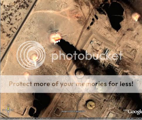
EDIT: One more question: Anybody else seen the pictures of southern Iraq? There's loads of explosions....
For some reason, the pictures automatically resize themselves when I upload them onto the internet, I apologise.
[edit on 1-10-2005 by xeroxed88]
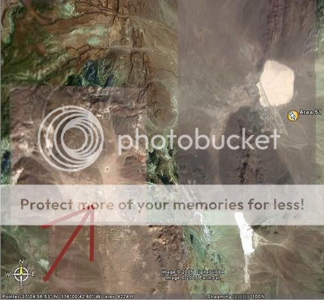
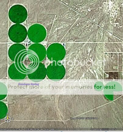
WTF are these areas?
1) Very close to the west of Area 51, if you look at that area on Google Earth, it looks like some kind of bomb testing ground, am I right in thinking that? Follow the craters down southwards until you reach Yucca Lake, there's more cars and hangars...
2) I've seen these green circles all over the World using Google Earth, this particular set is just north of A51. Can anybody tell me what they are please?
Thank you.
EDIT: One more question: Anybody else seen the pictures of southern Iraq? There's loads of explosions....
For some reason, the pictures automatically resize themselves when I upload them onto the internet, I apologise.
[edit on 1-10-2005 by xeroxed88]
Originally posted by xeroxed88
1) Very close to the west of Area 51,
if you look at that area on Google Earth,
it looks like some kind of bomb testing ground...
2) I've seen these green circles all over the World
using Google Earth, this particular set is just north
of A51. Can anybody tell me what they are please?...
1) - Nevada Test Site. Dozens of nuclear above and underground
tests in the 60's.
2) - Circular irrigation. Big sprinkler on a wheeled pipe. rotates
on a quarter mile radius. Commercial hay farms in this case.
Sarge
For the first one, turn on the "Community BBS Layer" or whatever it's called and go to the bomb area and it'll have the name of each crater.
For the 3rd one, maybe it's oil burning.
For the 3rd one, maybe it's oil burning.
It's a lens flare actually. They're on alot of the oil things around Iraq on Google Earth.
Area 51 Baseball Field
Interesting, didn't know they had a baseball field. For the aliens that visit to play a game of america's favorites pasttime?
Interesting, didn't know they had a baseball field. For the aliens that visit to play a game of america's favorites pasttime?
new topics
-
Smartest Man in the World Tells His Theory About What Happens At Death
Philosophy and Metaphysics: 1 hours ago -
Covid....... Again.
Diseases and Pandemics: 3 hours ago -
US Federal Funding set to Expire December 20th. Massive CR on the way.
Mainstream News: 4 hours ago -
and14263 New Account Not the Same Old Me
Introductions: 5 hours ago
top topics
-
Covid....... Again.
Diseases and Pandemics: 3 hours ago, 9 flags -
US Federal Funding set to Expire December 20th. Massive CR on the way.
Mainstream News: 4 hours ago, 7 flags -
The truth lets admit it
Aliens and UFOs: 17 hours ago, 6 flags -
Just spotted an unusual aircraft Melbourne Australia
Aliens and UFOs: 12 hours ago, 6 flags -
Smartest Man in the World Tells His Theory About What Happens At Death
Philosophy and Metaphysics: 1 hours ago, 5 flags -
and14263 New Account Not the Same Old Me
Introductions: 5 hours ago, 2 flags
active topics
-
The truth lets admit it
Aliens and UFOs • 53 • : Naftalin -
Smartest Man in the World Tells His Theory About What Happens At Death
Philosophy and Metaphysics • 8 • : Wookiep -
Covid....... Again.
Diseases and Pandemics • 16 • : DoubleDNH -
The Acronym Game .. Pt.4
General Chit Chat • 1022 • : tinkerbell99 -
Trump Cancel trip to New Jersey because of drones
Aliens and UFOs • 72 • : ARM19688 -
Russias War Against Religion in Ukraine
World War Three • 34 • : andy06shake -
Could rampant land speculation have caused the Civil War?
History • 41 • : Solvedit -
Just spotted an unusual aircraft Melbourne Australia
Aliens and UFOs • 5 • : andy06shake -
Lowrider Car Show
Automotive Discussion • 18 • : Naftalin -
and14263 New Account Not the Same Old Me
Introductions • 8 • : DontTreadOnMe