It looks like you're using an Ad Blocker.
Please white-list or disable AboveTopSecret.com in your ad-blocking tool.
Thank you.
Some features of ATS will be disabled while you continue to use an ad-blocker.
13
share:
Hurricane Lee hits a cat 5 pressure based on drop sonde data is 928 Mb. Thankfully so far it looks like it will spare the Caribbean and highly
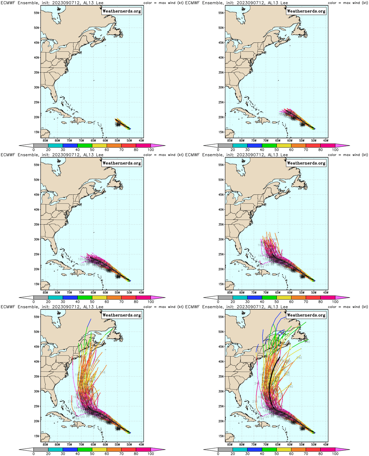
likely it will miss the continental US. However, that is so far out, anything past 5 days... you can see a few of the European models have it possibly
getting west enough to at least make it worth watching by next Wednesday

www.nhc.noaa.gov...

www.nhc.noaa.gov...
BULLETIN
Hurricane Lee Advisory Number 11
NWS National Hurricane Center Miami FL AL132023
1100 PM AST Thu Sep 07 2023
...LEE BECOMES A CATEGORY 5 HURRICANE...
...DANGEROUS BEACH CONDITIONS EXPECTED TO DEVELOP AROUND THE
WESTERN ATLANTIC THROUGH EARLY NEXT WEEK...
SUMMARY OF 1100 PM AST...0300 UTC...INFORMATION
-----------------------------------------------
LOCATION...17.3N 52.4W
ABOUT 705 MI...1135 KM E OF THE NORTHERN LEEWARD ISLANDS
MAXIMUM SUSTAINED WINDS...160 MPH...260 KM/H
PRESENT MOVEMENT...WNW OR 295 DEGREES AT 14 MPH...22 KM/H
MINIMUM CENTRAL PRESSURE...928 MB...27.41 INCHES
WATCHES AND WARNINGS
--------------------
There are no coastal watches or warnings in effect.
DISCUSSION AND OUTLOOK
----------------------
At 1100 PM AST (0300 UTC), the center of Hurricane Lee was located
near latitude 17.3 North, longitude 52.4 West. Lee is moving toward
the west-northwest near 14 mph (22 km/h), and this motion is
expected to continue through early next week with a significant
decrease in forward speed. On the forecast track, Lee is expected
to pass well to the north of the northern Leeward Islands, the
Virgin Islands, and Puerto Rico over the weekend and into early
next week.
Data from an Air Force Reserve Hurricane Hunter aircraft indicate
that maximum sustained winds have increased to near 160 mph (260
km/h) with higher gusts. Lee is a category 5 hurricane on the
Saffir-Simpson Hurricane Wind Scale. Additional strengthening is
forecast overnight. Fluctuations in intensity are likely over the
next few days, but Lee is expected to remain a major hurricane
through early next week.
Hurricane-force winds extend outward up to 45 miles (75 km) from the
center and tropical-storm-force winds extend outward up to 140 miles
(220 km).
The minimum central pressure based on dropsonde data is 928 mb
(27.41 inches).
Nature is amazing.
I’ve been through a few hurricanes, seen several tornadoes.
Watched one smaller tornado f1-f2 come right for me, then last minute veer left and tore the roof off the shed.
Beautiful, even in destruction.
I’ve been through a few hurricanes, seen several tornadoes.
Watched one smaller tornado f1-f2 come right for me, then last minute veer left and tore the roof off the shed.
Beautiful, even in destruction.
When I was kid my parents got me a book Eyewitness to Disaster and it had a section on Hurricane Camille I've been a bit of a Hurricane nerd ever
since. Obviously know the big ones Andrew Hugo, and Katrina etc. but I used to travel throughout Florida and the southeast I know these areas fairly
well, so when one hits I've usually been there before.
I've never been in one but we were in Lauderdale when one was fairly offshore in the 80s, The waves on in the Atlantic were huge we spent half a day getting wiped out in the surf.
Hell during Idalia I signed up for one of the Storm Trackers Patreon and I watched his cameras all night long.
I've never been in one but we were in Lauderdale when one was fairly offshore in the 80s, The waves on in the Atlantic were huge we spent half a day getting wiped out in the surf.
Hell during Idalia I signed up for one of the Storm Trackers Patreon and I watched his cameras all night long.
I had just moved to Dunn after finishing my tour in the USAF. I had never encountered a hurricane before and had no idea what to expect. Hurricane
Fran came up the Cape Fear River and directly hit our location. When I say direct hit, I mean I was able to go outside and stand inside the eye and
see the walls, feel the pressure, feel the eerie calmness. I have been through quite a few since then, but never one like that.
I did learn that even if it's hot and miserable outside, you don't have power and you spend the day cleaning up downed trees, having a hot shower at the end of the day is an amazing feeling. I have never forgot how good that felt and have engineered my house so that I can do that in almost any scenario.
I did learn that even if it's hot and miserable outside, you don't have power and you spend the day cleaning up downed trees, having a hot shower at the end of the day is an amazing feeling. I have never forgot how good that felt and have engineered my house so that I can do that in almost any scenario.
originally posted by: putnam6
Hell during Idalia I signed up for one of the Storm Trackers Patreon and I watched his cameras all night long.
I have family on the west coast of Florida so I watched Idalia closely. It moved really fast and I didn't have to agonize too long about where it would hit. Lee is a slowpoke and its hard (for me at least) to see where its ultimately headed. Who knows, it might go over DC in which case, Biden won't have an excuse not to visit the disaster area.
A well-documented cookbook from 2005 on flavorful and healthy meals to prepare when your normal power sources are unavailable due to approaching
hurricanes:
books.google.com...
books.google.com...
Removed
edit on 9.8.2023 by Zarniwoop because: (no reason given)
True that
originally posted by: LogicalGraphitti
originally posted by: putnam6
Hell during Idalia I signed up for one of the Storm Trackers Patreon and I watched his cameras all night long.
I have family on the west coast of Florida so I watched Idalia closely. It moved really fast and I didn't have to agonize too long about where it would hit. Lee is a slowpoke and its hard (for me at least) to see where its ultimately headed. Who knows, it might go over DC in which case, Biden won't have an excuse not to visit the disaster area.
It has rapidly weakened yesterday, as it strengthened a day ago.
It got hit with shear.
It’s projected strengthen again this weekend, however it might not regain its former cat 5 status. We will see.
I’ve also have been following it daily on satellite as it came off the coast of Africa as a wave last weekend.
Even if it doesn’t go back to its cat 5 status, it’s still a remarkable feat how fast it strengthened.
On the other side in the eastern pacific, Hurricane Jova also rapidly intensified into a cat 5 this past week and weakened as fast. And was a beaut.
edit on 9-9-2023 by Imhere because: (no reason given)
I bet Oprah started this hurricane , because she wants to buy cheap land . Lmao 🤣
originally posted by: network dude
I had just moved to Dunn after finishing my tour in the USAF. I had never encountered a hurricane before and had no idea what to expect. Hurricane Fran came up the Cape Fear River and directly hit our location. When I say direct hit, I mean I was able to go outside and stand inside the eye and see the walls, feel the pressure, feel the eerie calmness. I have been through quite a few since then, but never one like that.
I did learn that even if it's hot and miserable outside, you don't have power and you spend the day cleaning up downed trees, having a hot shower at the end of the day is an amazing feeling. I have never forgot how good that felt and have engineered my house so that I can do that in almost any scenario.
new topics
-
RIP James Earl Jones 93
People: 14 minutes ago -
Kamala Harris Campaign Site Lists Policy Page Seven Weeks After Entering Race
2024 Elections: 1 hours ago -
Ruth and 1 Samuel
Religion, Faith, And Theology: 2 hours ago -
Opinion Beijing set out to destroy U.S. economic supremacy. It’s nearing its target.
Other Current Events: 4 hours ago -
Farmers Almanac Winter 2024/2025 "Calmer Gentler Winter"
General Chit Chat: 6 hours ago -
Japanese Researchers Link Covid Shots to 201 Dangerous Diseases
Science & Technology: 6 hours ago -
This person could be our next president.
Politicians & People: 7 hours ago -
Would you like fries with that?
US Political Madness: 9 hours ago
top topics
-
Would you like fries with that?
US Political Madness: 9 hours ago, 22 flags -
This person could be our next president.
Politicians & People: 7 hours ago, 12 flags -
Japanese Researchers Link Covid Shots to 201 Dangerous Diseases
Science & Technology: 6 hours ago, 12 flags -
Kamala Harris Campaign Site Lists Policy Page Seven Weeks After Entering Race
2024 Elections: 1 hours ago, 7 flags -
Farmers Almanac Winter 2024/2025 "Calmer Gentler Winter"
General Chit Chat: 6 hours ago, 6 flags -
Opinion Beijing set out to destroy U.S. economic supremacy. It’s nearing its target.
Other Current Events: 4 hours ago, 6 flags -
Facebook slowing down access to political posts
Education and Media: 12 hours ago, 5 flags -
RIP James Earl Jones 93
People: 14 minutes ago, 4 flags -
Ruth and 1 Samuel
Religion, Faith, And Theology: 2 hours ago, 2 flags
active topics
-
Donald TRUMP on the Fate of Election Fraudsters if Americans Elect Him President Again.
2024 Elections • 76 • : Xtrozero -
Opinion Beijing set out to destroy U.S. economic supremacy. It’s nearing its target.
Other Current Events • 15 • : putnam6 -
The Nephilim Looked Like Clowns
General Conspiracies • 31 • : TheLieWeLive -
Would you like fries with that?
US Political Madness • 33 • : asabuvsobelow -
RIP James Earl Jones 93
People • 0 • : wAnchorofCarp -
-@TH3WH17ERABB17- -Q- ---TIME TO SHOW THE WORLD--- -Part- --44--
Dissecting Disinformation • 2532 • : angelchemuel -
Show me the financial gain Trump got from being POTUS.
US Political Madness • 68 • : JadedGhost -
Nano bots in the vaccine
Science & Technology • 98 • : SteamyAmerican -
Massive Protest Over X Ban in Brasil September 7 Led By Former Leader Jair Bolsonaro
Social Issues and Civil Unrest • 23 • : chr0naut -
This person could be our next president.
Politicians & People • 52 • : DAVID64
13
