It looks like you're using an Ad Blocker.
Please white-list or disable AboveTopSecret.com in your ad-blocking tool.
Thank you.
Some features of ATS will be disabled while you continue to use an ad-blocker.
24
share:
I can't remember seeing a high pressure system this large before. I'm sure some [.] will say it's an everyday occurrence. But I've watched the weather
for over 30 years and don't recall anything this big.
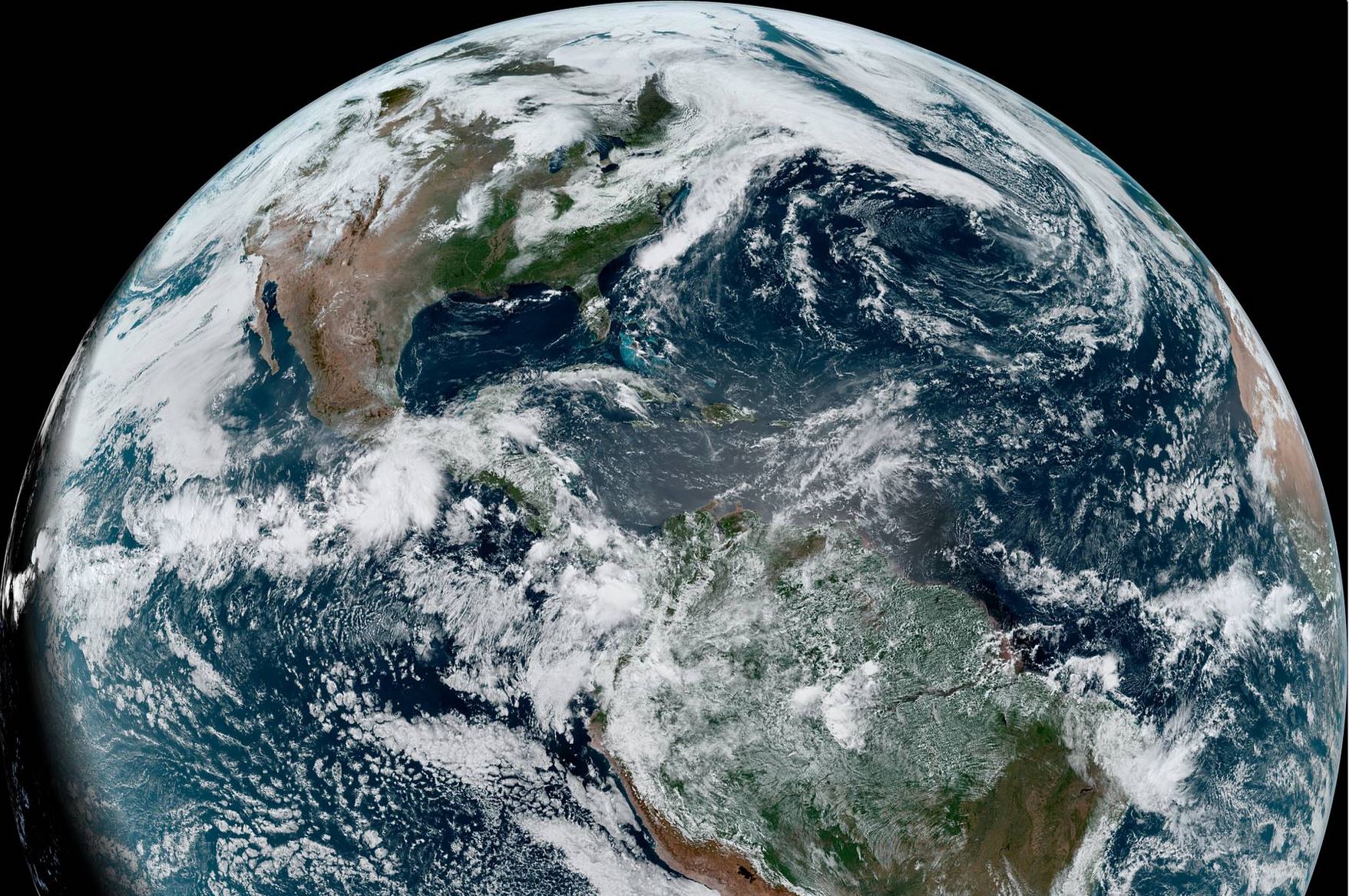
www.star.nesdis.noaa.gov...
The center of this system is at least the width of Indiana (and maybe Ohio too). It's outer spiral arms reach the continents of Africa, South America and the USA. It's Southern portion is blowing up into the Gulf of Mexico. So much, that it may disrupt the Tropical Storm (or soon Cyclone) Agatha from entering into the Gulf. Or worse, providing it fuel.
On a side note, perhaps it's fouling up the infra red sensors of Soviet satellites or RADAR as well.
Community Announcement re: Decorum
edit on Sun May 29 2022 by DontTreadOnMe
because: (no reason given)
not a troll or fairy but want to learn more... is this just the normal Bermuda High perhaps on steroids? With half the country in drought issues, how
would it affect the rain forecast
a reply to: Violater1
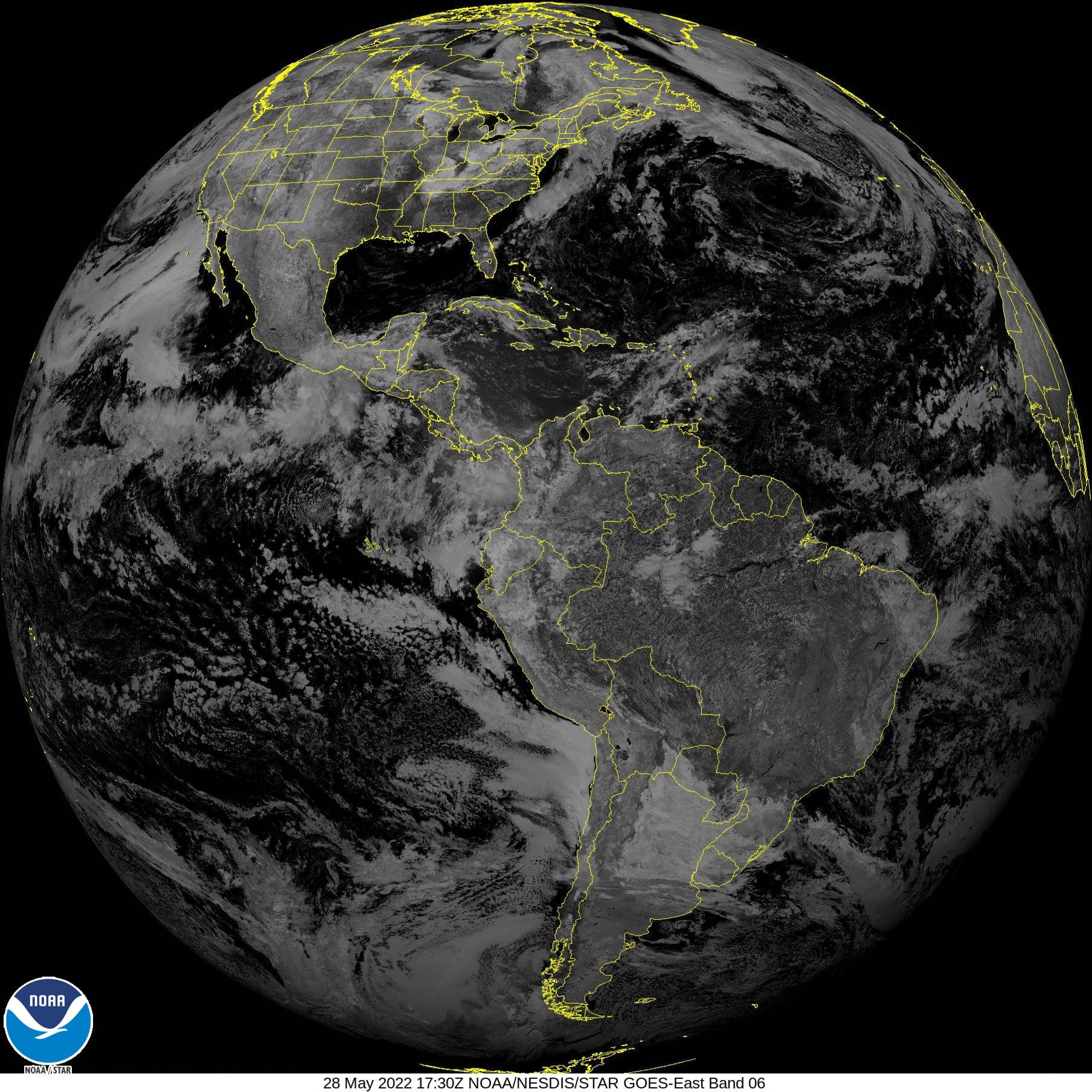
Here, a satellite animation from GOES-east, it's near IR sensor can pick up clouds. Fresh from NOAA.
www.star.nesdis.noaa.gov...
oh lol, should have clicked the link in your OP, same SAT just different sensor, duh.
Here, a satellite animation from GOES-east, it's near IR sensor can pick up clouds. Fresh from NOAA.

www.star.nesdis.noaa.gov...
oh lol, should have clicked the link in your OP, same SAT just different sensor, duh.
edit on 28.5.2022 by TDDAgain because: (no reason
given)
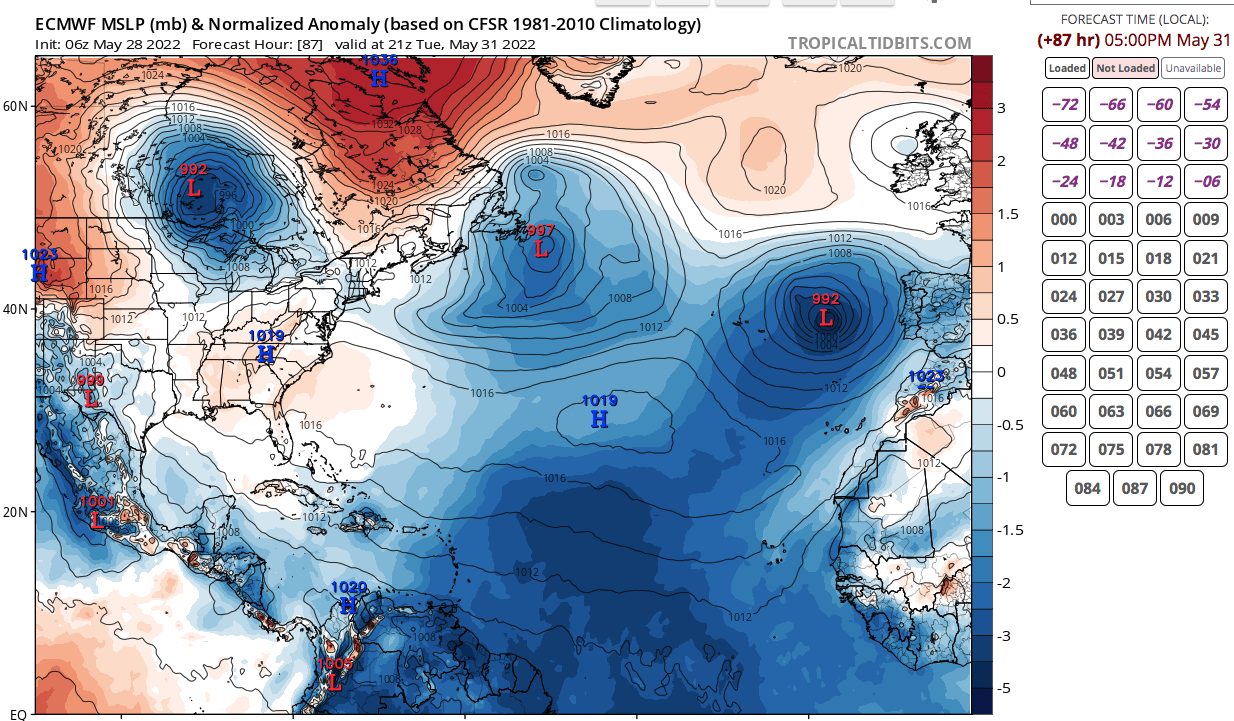
FWIW Tropical Tidbits has it shifting southeast and collapsing by the 31st on the Euro model, while the EPS has it shifting northeast and emerging
with another high-pressure system if Im channeling Al Roker properly
www.tropicaltidbits.com...
www.tropicaltidbits.com...

a reply to: Violater1
Its the Bermuda High, it generally establishes itself this time if year. Also you can also often predict the likely paths of hurricanes later this summer and fall based on where the high is set up now as the cyclones tend to move around the perimeter of the high.
Given where it is right now, most 'Cape Verde' storms will likely turn north before the CONUS...good news!
This is subject to change, but is generally a good indicator. Hurricane seasons with a lot of CONUS strikes, the Bermuda High is further west, preventing the storms from turning north before running into the CONUS. Right now it is in a favorable location as it would allow storms to turn north along the western perimeter of the high before threatening the US.
originally posted by: jrod
a reply to: Violater1
Its the Bermuda High, it generally establishes itself this time if year. Also you can also often predict the likely paths of hurricanes later this summer and fall based on where the high is set up now as the cyclones tend to move around the perimeter of the high.
Given where it is right now, most 'Cape Verde' storms will likely turn north before the CONUS...good news!
This is subject to change, but is generally a good indicator. Hurricane seasons with a lot of CONUS strikes, the Bermuda High is further west, preventing the storms from turning north before running into the CONUS. Right now it is in a favorable location as it would allow storms to turn north along the western perimeter of the high before threatening the US.
Well, that's good and that's bad, cause maybe a hurricane in Florida becomes much-needed rain in Appalachia. Ive seen a hurricane hit the panhandle of Florida and the ensuing rain in Georgia saved the peanut and pecan crop as long as we can keep the 3-5 at a minimum or it doesn't stall like the one in Texas did. Cause conversely Ive also seen a hurricane move slowly through Georgia and bring historic flooding and ruined crops. It's a huge give and take.
Sounds interesting. I do not track big events like this so I have not researched about them much. I do do a little reading on Hurricanes paths, and
I do much more research on how Tornado paths are created, but nothing even close to anything like this thing.
I never even knew that this kind of thing existed actually. How does this effect weather patterns?
I never even knew that this kind of thing existed actually. How does this effect weather patterns?
Being that the high pressure system is so huge, along with the effects of La Nina, it could have a large effect on weather patterns in the region. I
agree with those of you who stated it will affect where hurricanes eventually land, or don't land.
originally posted by: putnam6
FWIW Tropical Tidbits has it shifting southeast and collapsing by the 31st on the Euro model, while the EPS has it shifting northeast and emerging with another high-pressure system if Im channeling Al Roker properly
www.tropicaltidbits.com...
Thank you for this graphic. We can now see that the center was at that time, was 1019 millibars or 30.091050 Inches of Mercury. The average sea level air pressure is 1013.25 millibars. Tropical low pressure systems are classified as hurricanes when their pressure is 980 millibars or lower, and sustained wind speeds are greater than around 73 mph. The massive size of the center of this high pressure system, as we can see, is wider than than the combined States of Illinois, Indiana, and Ohio.
Currently, the High Pressure system has gotten stronger over that last several hours. It has increased to 1028 millibars.
It's pressure waves (1012 millibars) have stretched all the way to Tropical Storm Agatha (1005 millibars). This may have just spared the Gulf of Mexico a devastating hurricane.
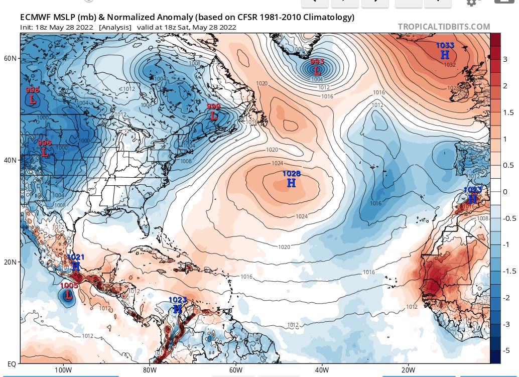
It's pressure waves (1012 millibars) have stretched all the way to Tropical Storm Agatha (1005 millibars). This may have just spared the Gulf of Mexico a devastating hurricane.

a reply to: putnam6
Hurricanes are regional aquifer suppliers so they do serve a much needed purpose of ground water replenishment. As well as providing precipitation during the height of the growing season. But I've seen summer rains channeling up the entire east coast in a train leading to flooding which was as bad or worse than slow moving hurricanes.
And on that subject, many of these " storm of the century hurricanes" aren't even huge or powerful storms, they just stall when confronted by a high pressure and move slowly and release their rain over an area without being able to move off. High pressures dominated in the past few years making these storms particularly damaging.
I don’t know enough to understand. But it’ll be interesting to see if we have some unusual “natural” disasters like Puerto Rico.
originally posted by: Violater1
I can't remember seeing a high pressure system this large before. I'm sure some [.] will say it's an everyday occurrence. But I've watched the weather for over 30 years and don't recall anything this big.
www.star.nesdis.noaa.gov...
The center of this system is at least the width of Indiana (and maybe Ohio too). It's outer spiral arms reach the continents of Africa, South America and the USA. It's Southern portion is blowing up into the Gulf of Mexico. So much, that it may disrupt the Tropical Storm (or soon Cyclone) Agatha from entering into the Gulf. Or worse, providing it fuel.
On a side note, perhaps it's fouling up the infra red sensors of Soviet satellites or RADAR as well.
Community Announcement re: Decorum
a reply to: Dutchowl
How about disrupting tornadoes using high power sound blasts/ ultrasonic beam blasts or using concert loudspeakers mounted on pickup trucks to disrupt it or using vortex cannons or using tanks /artillery to fire high explosives shells at the center of the tornado or firing lasers instead of standing AROUND helplessly?
How about disrupting tornadoes using high power sound blasts/ ultrasonic beam blasts or using concert loudspeakers mounted on pickup trucks to disrupt it or using vortex cannons or using tanks /artillery to fire high explosives shells at the center of the tornado or firing lasers instead of standing AROUND helplessly?
new topics
-
January 6th report shows disturbing trend (nobody is shocked)
US Political Madness: 1 hours ago -
Inexplicable military simulation - virtual reality showdown in the night..
The Gray Area: 1 hours ago -
The Truth about Migrant Crime in Britain.
Social Issues and Civil Unrest: 2 hours ago -
Trudeau Resigns! Breaking
Other Current Events: 4 hours ago -
Live updates: Congress meets to certify Trump's presidential election victory
US Political Madness: 5 hours ago -
Gravitic Propulsion--What IF the US and China Really Have it?
General Conspiracies: 6 hours ago -
Greatest thing you ever got, or bought?
General Chit Chat: 6 hours ago
top topics
-
Trudeau Resigns! Breaking
Other Current Events: 4 hours ago, 22 flags -
Live updates: Congress meets to certify Trump's presidential election victory
US Political Madness: 5 hours ago, 12 flags -
OK this is sad but very strange stuff
Paranormal Studies: 17 hours ago, 9 flags -
January 6th report shows disturbing trend (nobody is shocked)
US Political Madness: 1 hours ago, 8 flags -
The Truth about Migrant Crime in Britain.
Social Issues and Civil Unrest: 2 hours ago, 7 flags -
Gravitic Propulsion--What IF the US and China Really Have it?
General Conspiracies: 6 hours ago, 6 flags -
Greatest thing you ever got, or bought?
General Chit Chat: 6 hours ago, 3 flags -
Inexplicable military simulation - virtual reality showdown in the night..
The Gray Area: 1 hours ago, 0 flags
active topics
-
Trudeau Resigns! Breaking
Other Current Events • 53 • : underpass61 -
January 6th report shows disturbing trend (nobody is shocked)
US Political Madness • 4 • : BeyondKnowledge3 -
Sorry to disappoint you but...
US Political Madness • 29 • : Kaiju666 -
The Truth about Migrant Crime in Britain.
Social Issues and Civil Unrest • 11 • : putnam6 -
Greatest thing you ever got, or bought?
General Chit Chat • 20 • : lilzazz -
-@TH3WH17ERABB17- -Q- ---TIME TO SHOW THE WORLD--- -Part- --44--
Dissecting Disinformation • 3952 • : AianawaQ1320 -
Live updates: Congress meets to certify Trump's presidential election victory
US Political Madness • 17 • : Dalamax -
Inexplicable military simulation - virtual reality showdown in the night..
The Gray Area • 1 • : lilzazz -
Gravitic Propulsion--What IF the US and China Really Have it?
General Conspiracies • 7 • : Mantiss2021 -
Musk calls on King Charles III to dissolve Parliament over Oldham sex grooming gangs
Mainstream News • 195 • : Oldcarpy2
24
