It looks like you're using an Ad Blocker.
Please white-list or disable AboveTopSecret.com in your ad-blocking tool.
Thank you.
Some features of ATS will be disabled while you continue to use an ad-blocker.
share:
a reply to: Blaine91555
You know it would make a lot more sense to just consider that they built their city on a really cool naturally occurring geological feature than to have assumed they built the whole thing.
I mean imagine the manpower and hours necessary to construct something of this magnitude out of a flat area, and then flood the canals afterwards. It probably isn't even possible without being a Type 1 or 2 civilization.
We have all the evidence of major flooding nearby, so all we really need now is to find significant remains of a city on top of the rings themselves to clinch the prize.
a reply to: muzzleflash
The "Argument" isn't necessarily directed at the Choir. But is a Argument that must get as much publicity as possible. Though, I must admit I am so convinced this is the site that I tend not to look at other arguments, at least until the evidence is given a fair and honest review.
In as far as being wrong, sure, possible. Its possible this site had another name, or names it went by. So, technically its possible it is completely out of context, and we are wrong. But we are not wrong about something was there, a long time ago. The Evidence dictates that.
So I ask you, what are the chances this was also known as Eridu? And the site in Summer is incorrect?
originally posted by: muzzleflash
a reply to: All Seeing Eye
Check it out:
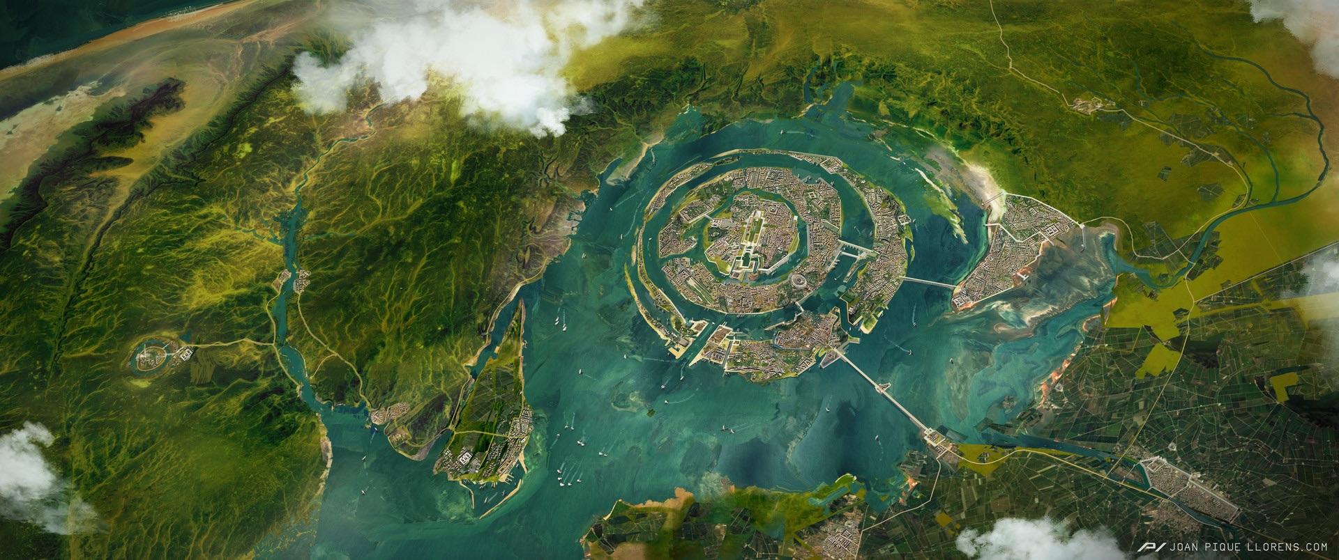
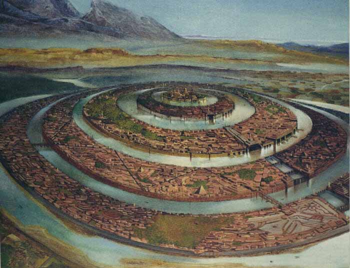
Artist's rendition? Coordinates if real, please.
a reply to: All Seeing Eye
And an argument can be made for Atlantis being in the Rovigo and Ferrara area on Italy. In fact based on the facts of the war that was taking place between Athens and the Atlantis controlled forces, I would say that the plains of Italy makes much better sense.
If you want to really push the story out there then again Cruiser Tablemount would be a better candidate then the Richat, but the big disqualifier for either of these is that the mud flow that trapped sailors only would have been possible in the Rovigo and Ferrara area after a Glacial collapse in the Alps happened. Which would have been possible during the time of the Athenian/Atlantean war.
a reply to: All Seeing Eye
Yeah I found that art awhile back when I was looking into the Richat and realizing that this is by far the best candidate for Atlantis. When I saw how excited you were by the topic I knew you'd really appreciate it too.
Yeah I found that art awhile back when I was looking into the Richat and realizing that this is by far the best candidate for Atlantis. When I saw how excited you were by the topic I knew you'd really appreciate it too.
originally posted by: muzzleflash
originally posted by: Blaine91555
I'm not sure I get what they would be hoping to find. What the Richat Structure is, is well known. Before I watch it, are they just playing off the myth of it being something other than the geologic feature it's know to be, a heavily eroded dome?
Near as I can tell people just ignore that it's been studied and mapped and instead embrace the odd made up theories about it being something else. "Atlantis in the Desert" being in the title would make me think it's not worth the bother.
I know they have found interesting artifacts in the area, but that does not change the facts about what it actually is. An igneous intrusion caused the uplift, so there really is no mystery as to what it is.
Sure it could be naturally formed, but that doesn't mean mankind couldn't have built a city on it and modified it a little bit.... right??
Not could be, it is. Mapped studied and understood. Yes, it could have been used by an old civilization, but that's just throwing stuff at the wall to see if it sticks IMO. It's concentric circles, so therefore it must be the mythical city of Atlantis.
a reply to: Guyfriday
All of the alternative Atlantian hypothesis are absurd (except Antarctica) and the Richat fits the descriptions handed down to us perfectly.
Wiki Atlantis
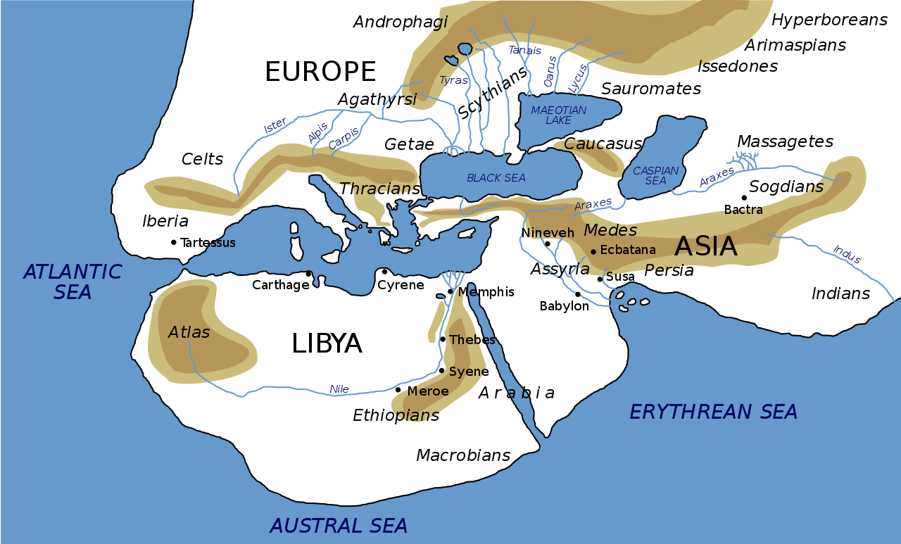
Keep in mind this map based on Herodotus' accounts is a vague representation. Notice where the mountain of Atlas is located - the Richat is directly south of this.
Also imagine that the seas were very different in this time - that the Sahara and Western Africa were islands rather than the currently fully emerged section of the continent we now consider it. The supposed earthquakes could have easily changed the landscape and shifted the elevation and sea levels. Only a small change of a small area is required to have accomplished this in a limited geographical zone.
Also note that the map showing the Nile going west is not as we know it today - going south instead. This is a discrepancy that we must reconcile.

This is so obvious and right in front of our faces, it's incredible it has only now in the last few years become well known.
Keep in mind that the mount of Atlas was due north and that the fastest route to the inner Mediterranean was to go by sea - as this was a seafaring civilization - and they would travel along the west coast of the African islands up around the straights of Gibraltar (pillars of Hercules) - and then in past Spain/Libya.
Now, this map is a reconstruction of the assumed Atlantian empire based off the limited information drawn on in Ignatius L. Donnelly's Atlantis: the Antediluvian World, 1882:
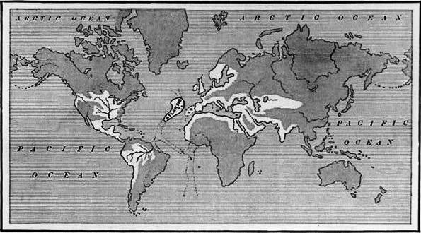
He was assuming that the current West African landscape was exactly as we know it today - he was forgetting that mass earthquakes had changed that landscape ending the the ultimate destruction of the Atlantian 3 ringed island structure.
Cmon man you are actually suggesting Italy (what??) or somewhere in the middle of the Atlantic (how is this part of Atlas mountains?) when we have this staring us right in the face??
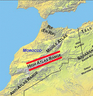
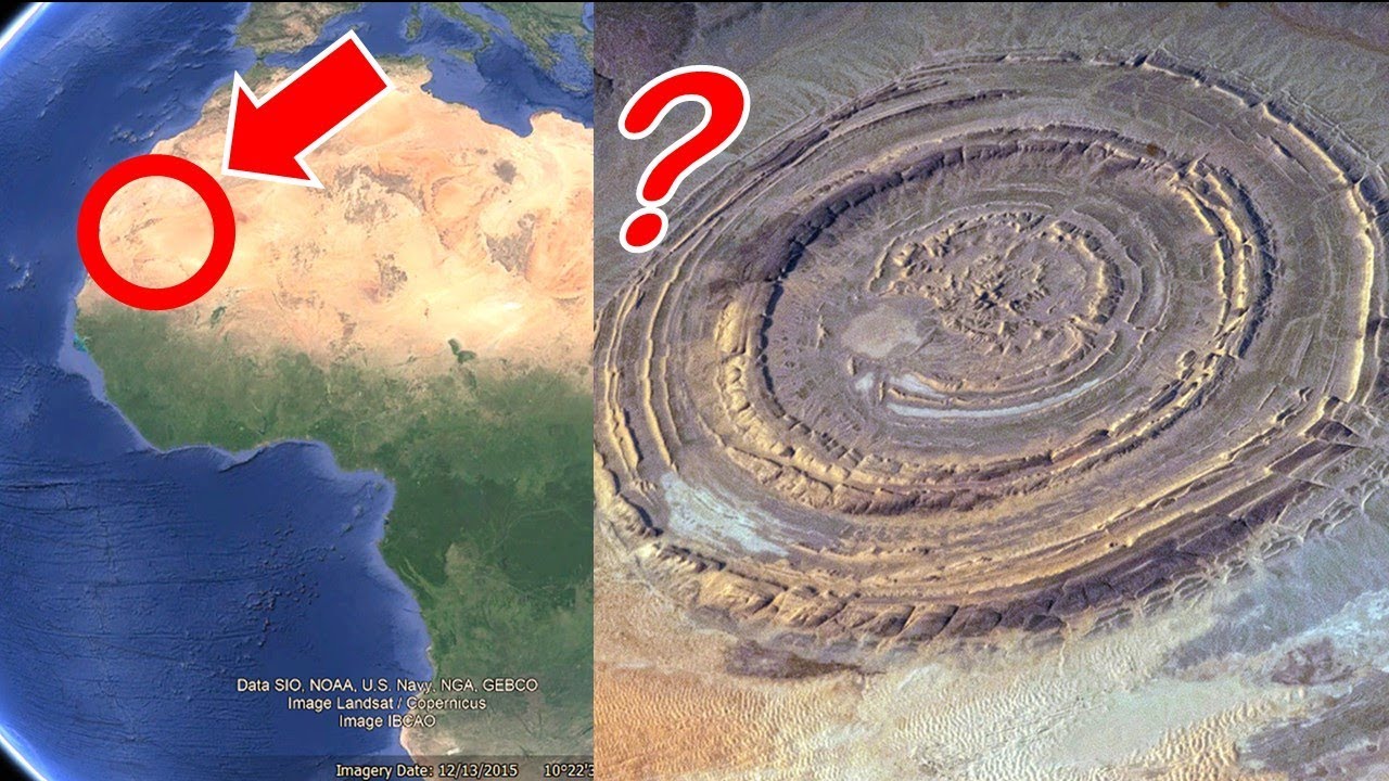

Look at the evidence of the massive mudflow ---
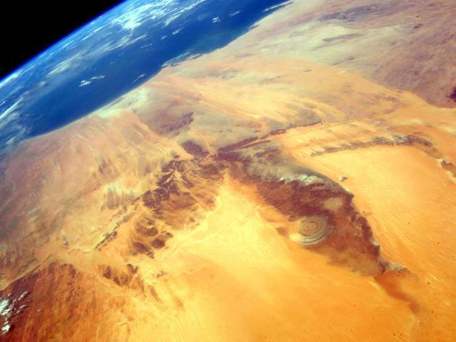
This has gotta be it! Fit's perfectly with our actual historical accounts!!
All of the alternative Atlantian hypothesis are absurd (except Antarctica) and the Richat fits the descriptions handed down to us perfectly.
Wiki Atlantis
In Plato's metaphorical tale, Poseidon fell in love with Cleito, the daughter of Evenor and Leucippe, who bore him five pairs of male twins. The eldest of these, Atlas, was made rightful king of the entire island and the ocean (called the Atlantic Ocean in his honor), and was given the mountain of his birth and the surrounding area as his fiefdom.

Keep in mind this map based on Herodotus' accounts is a vague representation. Notice where the mountain of Atlas is located - the Richat is directly south of this.
Also imagine that the seas were very different in this time - that the Sahara and Western Africa were islands rather than the currently fully emerged section of the continent we now consider it. The supposed earthquakes could have easily changed the landscape and shifted the elevation and sea levels. Only a small change of a small area is required to have accomplished this in a limited geographical zone.
Also note that the map showing the Nile going west is not as we know it today - going south instead. This is a discrepancy that we must reconcile.
Poseidon carved the mountain where his love dwelt into a palace and enclosed it with three circular moats of increasing width, varying from one to three stadia and separated by rings of land proportional in size. The Atlanteans then built bridges northward from the mountain, making a route to the rest of the island. They dug a great canal to the sea, and alongside the bridges carved tunnels into the rings of rock so that ships could pass into the city around the mountain; they carved docks from the rock walls of the moats. Every passage to the city was guarded by gates and towers, and a wall surrounded each ring of the city. The walls were constructed of red, white, and black rock, quarried from the moats, and were covered with brass, tin, and the precious metal orichalcum, respectively.

This is so obvious and right in front of our faces, it's incredible it has only now in the last few years become well known.
Keep in mind that the mount of Atlas was due north and that the fastest route to the inner Mediterranean was to go by sea - as this was a seafaring civilization - and they would travel along the west coast of the African islands up around the straights of Gibraltar (pillars of Hercules) - and then in past Spain/Libya.
Now, this map is a reconstruction of the assumed Atlantian empire based off the limited information drawn on in Ignatius L. Donnelly's Atlantis: the Antediluvian World, 1882:

He was assuming that the current West African landscape was exactly as we know it today - he was forgetting that mass earthquakes had changed that landscape ending the the ultimate destruction of the Atlantian 3 ringed island structure.
Cmon man you are actually suggesting Italy (what??) or somewhere in the middle of the Atlantic (how is this part of Atlas mountains?) when we have this staring us right in the face??


Look at the evidence of the massive mudflow ---

This has gotta be it! Fit's perfectly with our actual historical accounts!!
originally posted by: Blaine91555
originally posted by: muzzleflash
originally posted by: Blaine91555
I'm not sure I get what they would be hoping to find. What the Richat Structure is, is well known. Before I watch it, are they just playing off the myth of it being something other than the geologic feature it's know to be, a heavily eroded dome?
Near as I can tell people just ignore that it's been studied and mapped and instead embrace the odd made up theories about it being something else. "Atlantis in the Desert" being in the title would make me think it's not worth the bother.
I know they have found interesting artifacts in the area, but that does not change the facts about what it actually is. An igneous intrusion caused the uplift, so there really is no mystery as to what it is.
Sure it could be naturally formed, but that doesn't mean mankind couldn't have built a city on it and modified it a little bit.... right??
Not could be, it is. Mapped studied and understood. Yes, it could have been used by an old civilization, but that's just throwing stuff at the wall to see if it sticks IMO. It's concentric circles, so therefore it must be the mythical city of Atlantis.
Read my post above.
This is way more than a shot in the dark, it's an exact match.
You're just in disbelief that it was this obvious all along.
a reply to: muzzleflash
You do know that Atlantis is described in the Critias:
So um, where did the mud flow come from?
Now if you were to look at the Rovigo and Ferrara area of Italy you can also see the remains of an ancient mud flow, and you can even see that it came from the Alps. In fact given the stated date of 9000 years before the Critias takes place, there was a Glacial collapse of the Alpine ice sheet in the Würm glaciation (which ended 11,700 year's ago, or around 9000 years before the Critias was told).
The Alpine ice sheet collapse occurred during human habitation of the area, it was close enough to Attica region to allow for a conflict between them and Athens, and finally if the region had been hit with a massive landslide it would have effected the coast line of Attica as well. This is an important point since whatever happened to Atlantis was bad enough to effect Attica as well. How could something happen in Africa cause so much damage to Greece, but not wipe out all life in the Mediterranean?
You do know that Atlantis is described in the Critias:
Atlantis, which, as I was saying, was an island greater in extent than Libya and Asia, and when afterwards sunk by an earthquake, became an impassible barrier of mud to voyagers sailing from hence to any part of the ocean. The progress of the history will unfold the various nations of barbarians and families of Hellenes which then existed, as they successively appear on the scene;
So um, where did the mud flow come from?
Now if you were to look at the Rovigo and Ferrara area of Italy you can also see the remains of an ancient mud flow, and you can even see that it came from the Alps. In fact given the stated date of 9000 years before the Critias takes place, there was a Glacial collapse of the Alpine ice sheet in the Würm glaciation (which ended 11,700 year's ago, or around 9000 years before the Critias was told).
The Alpine ice sheet collapse occurred during human habitation of the area, it was close enough to Attica region to allow for a conflict between them and Athens, and finally if the region had been hit with a massive landslide it would have effected the coast line of Attica as well. This is an important point since whatever happened to Atlantis was bad enough to effect Attica as well. How could something happen in Africa cause so much damage to Greece, but not wipe out all life in the Mediterranean?
originally posted by: All Seeing Eye
a reply to: muzzleflash
So I ask you, what are the chances this was also known as Eridu? And the site in Summer is incorrect?
I don't know, but if we are to consider the flood myths and take the Sumerian version seriously about there being 5 cities pre-flood, and we are to consider the event that destroyed Plato's Atlantis to be that same flood event, than it must be one of those 5 cities.
We do have to fix the problem of dating - either it was 10,500 bc like the science we have now suggests (great year/procession of the equinoxes - comet cataclysm), or it was 2300 bc as Plato thought, or it was 1500 bc as related on the Parian Steele related to Deucalion or whatever date it is suppose to be. Gilgamesh was around 2700 to 2500 bc presumably.
The Gun-Yu Chinese flood myth is around 2300 bc.
Cessair the Irish flood myth is 2300bc
I can't find a reasonable dating for Bergelmir the Norse version or Manu the Hindi variant.
Also can't find the MesoAmerican or North American tribes, the Aborigines, or African tribes dating yet.
Will keep looking around, it's probably in the same vicinity.
Keep in mind almost all of the Noah/Genesis scholars date it around 2300 bc.
There are a lot of websites supposing that Eridu might be Atlantis but I can't really find anything solid, it's all pretty speculative and I'm not seeing hard links. If you know of any good stuff please share it. I checked the other 4 cities and couldn't find much either, there's too much to read I'm falling asleep. lol
I'll come back later I need a nap.
Speaking of Atlantis, or the ringed city, some of the things said about it may be blown out of proportion. In your artist's rendition it leaves you with the feeling that every square foot on the rings were taken up with structures. This, may not be the case. Though, the large structures in the center island, were there, it may not have been what we were lead to believe.
originally posted by: muzzleflash
a reply to: All Seeing Eye
Yeah I found that art awhile back when I was looking into the Richat and realizing that this is by far the best candidate for Atlantis. When I saw how excited you were by the topic I knew you'd really appreciate it too.
a reply to: muzzleflash
In the Critias it's noted as being 9000 years before that time. This would make it around 9300BC. I have never hear of it being around 2300bc. Even if we look at a possible mistranslation of 900 instead of 9000 years, we would still be sitting at 1200bc.
Science does show an ice sheet collapse taking place around the 11,000bc which as I already pointed out, would put it in the realm of possible locations.
a reply to: muzzleflash
The science is in on the desert conditions in North Africa. 6000 years ago.
Sahara Went from Green to Desert in a Flash
So from 4000 B.C. to 3000 B.C. it dried out.
The one thing Im certain of is that the Great Flood was not resposible for the destruction of this ringed city. And I suspect the great flood occured first, then the destruction of this city.
The science is in on the desert conditions in North Africa. 6000 years ago.
The findings come from analyses of dust blown west from Africa and dropped into the Atlantic Ocean. Researchers sifted through 30,000 years of dust and ocean bottom muck retrieved with ocean drilling ships. The changing levels of windblown dust in the ocean sediments provide scientists with clues to Africa's climate and how it has changed over time. Simply put, a lot of dust means drier conditions and less dust means a wetter environment
Sahara Went from Green to Desert in a Flash
So from 4000 B.C. to 3000 B.C. it dried out.
The one thing Im certain of is that the Great Flood was not resposible for the destruction of this ringed city. And I suspect the great flood occured first, then the destruction of this city.
originally posted by: muzzleflash
a reply to: Guyfriday
All of the alternative Atlantian hypothesis are absurd (except Antarctica) and the Richat fits the descriptions handed down to us perfectly.
Wiki Atlantis
In Plato's metaphorical tale, Poseidon fell in love with Cleito, the daughter of Evenor and Leucippe, who bore him five pairs of male twins. The eldest of these, Atlas, was made rightful king of the entire island and the ocean (called the Atlantic Ocean in his honor), and was given the mountain of his birth and the surrounding area as his fiefdom.
Keep in mind this map based on Herodotus' accounts is a vague representation. Notice where the mountain of Atlas is located - the Richat is directly south of this.
Also imagine that the seas were very different in this time - that the Sahara and Western Africa were islands rather than the currently fully emerged section of the continent we now consider it. The supposed earthquakes could have easily changed the landscape and shifted the elevation and sea levels. Only a small change of a small area is required to have accomplished this in a limited geographical zone.
Also note that the map showing the Nile going west is not as we know it today - going south instead. This is a discrepancy that we must reconcile.
Poseidon carved the mountain where his love dwelt into a palace and enclosed it with three circular moats of increasing width, varying from one to three stadia and separated by rings of land proportional in size. The Atlanteans then built bridges northward from the mountain, making a route to the rest of the island. They dug a great canal to the sea, and alongside the bridges carved tunnels into the rings of rock so that ships could pass into the city around the mountain; they carved docks from the rock walls of the moats. Every passage to the city was guarded by gates and towers, and a wall surrounded each ring of the city. The walls were constructed of red, white, and black rock, quarried from the moats, and were covered with brass, tin, and the precious metal orichalcum, respectively.
This is so obvious and right in front of our faces, it's incredible it has only now in the last few years become well known.
Keep in mind that the mount of Atlas was due north and that the fastest route to the inner Mediterranean was to go by sea - as this was a seafaring civilization - and they would travel along the west coast of the African islands up around the straights of Gibraltar (pillars of Hercules) - and then in past Spain/Libya.
Now, this map is a reconstruction of the assumed Atlantian empire based off the limited information drawn on in Ignatius L. Donnelly's Atlantis: the Antediluvian World, 1882:
He was assuming that the current West African landscape was exactly as we know it today - he was forgetting that mass earthquakes had changed that landscape ending the the ultimate destruction of the Atlantian 3 ringed island structure.
Cmon man you are actually suggesting Italy (what??) or somewhere in the middle of the Atlantic (how is this part of Atlas mountains?) when we have this staring us right in the face??
Look at the evidence of the massive mudflow ---
This has gotta be it! Fit's perfectly with our actual historical accounts!!
Well done Son.Now you connect this to the Vlar Global Continental Displacement Waves (your evidence is present on the VGCDW Model) I share with people and you are on track to avoiding the next Rapture with your chosen friends and Family.
Well done INDEED !!!!
originally posted by: Blaine91555
I know they have found interesting artifacts in the area, but that does not change the facts about what it actually is. An igneous intrusion caused the uplift, so there really is no mystery as to what it is.
Plato's story credited Poseidon as the creator of the rings.
And when an ancient writer says that "the gods" or "a god" did something, what do you think they are really saying?
originally posted by: muzzleflash
a reply to: Guyfriday
All of the alternative Atlantian hypothesis are absurd (except Antarctica) and the Richat fits the descriptions handed down to us perfectly.
Wiki Atlantis
In Plato's metaphorical tale, Poseidon fell in love with Cleito, the daughter of Evenor and Leucippe, who bore him five pairs of male twins. The eldest of these, Atlas, was made rightful king of the entire island and the ocean (called the Atlantic Ocean in his honor), and was given the mountain of his birth and the surrounding area as his fiefdom.
Keep in mind this map based on Herodotus' accounts is a vague representation. Notice where the mountain of Atlas is located - the Richat is directly south of this.
Also imagine that the seas were very different in this time - that the Sahara and Western Africa were islands rather than the currently fully emerged section of the continent we now consider it. The supposed earthquakes could have easily changed the landscape and shifted the elevation and sea levels. Only a small change of a small area is required to have accomplished this in a limited geographical zone.
Also note that the map showing the Nile going west is not as we know it today - going south instead. This is a discrepancy that we must reconcile.
Another possibility is that Atlantis was actually connected to the mainland, but the people of the day didn't know that it was.
Perhaps they simply assumed that, since Atlantean ships always arrived by traveling through the straight of Gibraltar, that the city must therefore be on a faraway continent, rather than simply on the other side of Africa.
Remember this story is being told from the perspective of the Greeks and/or Egyptians (or some kind of proto culture). Whose ship building and navigational abilities may have been far inferior to that of Atlantis.
Poseidon carved the mountain where his love dwelt into a palace and enclosed it with three circular moats of increasing width, varying from one to three stadia and separated by rings of land proportional in size. The Atlanteans then built bridges northward from the mountain, making a route to the rest of the island. They dug a great canal to the sea, and alongside the bridges carved tunnels into the rings of rock so that ships could pass into the city around the mountain; they carved docks from the rock walls of the moats. Every passage to the city was guarded by gates and towers, and a wall surrounded each ring of the city. The walls were constructed of red, white, and black rock, quarried from the moats, and were covered with brass, tin, and the precious metal orichalcum, respectively.
This is so obvious and right in front of our faces, it's incredible it has only now in the last few years become well known.
Keep in mind that the mount of Atlas was due north and that the fastest route to the inner Mediterranean was to go by sea - as this was a seafaring civilization - and they would travel along the west coast of the African islands up around the straights of Gibraltar (pillars of Hercules) - and then in past Spain/Libya.
Which could give the impression that they had come from some unknown island "outside the straight of Gibraltar".
Africa is a much bigger continent that most ancient maps make it to appear. Perhaps they only knew about half of its actual size?
originally posted by: KKLOCO
a reply to: muzzleflash
Thanks for the reply. Fortunately, these guys did take ground penetrating radar. UNFORTUNATELY, they were not allowed to use it. Local officials would not permit the use of GPR. This is one of the main reasons I found it anticlimactic.
Another reason being, that none of the rings seemed to have enough elevation from the supposed water ways. Making it very difficult to have any type of structures built there (if inundated with water in the past).
Blast from the past....
I have a feeling that outside of a Armed Invasion, the Government (Mauritania) and its contract agent UNESCO, will not permit any research into the buried structures. No digs.
Reason for that is simple. The corrupt world as we know it will begin to self destruct. The logic will follow, if Plato wasn't creating fiction about the ringed city, then he probably wasn't creating fiction when he discussed the gods, and demigods. Or, the demigod brothers blood oath to one another, and how that blood oath is still practiced today in "Secret Societies".
Then maybe all those brothers will realize that the oath they took was not to the Divine Creator, but to those gods, "Ancient Ones". They may even start to realize they have been committing treason against all of humanity.
Its all about, the blood, bloodlines, Blood Oaths..... I mean really, what fool would join a secret society not knowing what it was really all about? Well, to be honest it was a very clever trap............
edit on AMFridayFriday thAmerica/ChicagoAmerica/Chicago04911 by All Seeing Eye because: (no reason given)
originally posted by: Blaine91555
I'm not sure I get what they would be hoping to find. What the Richat Structure is, is well known. Before I watch it, are they just playing off the myth of it being something other than the geologic feature it's know to be, a heavily eroded dome?
Plato doesn't say that the rings were man made. He says that they cut canals through each ring to connect the water ways together.
But the creation of the rings themselves was attributed to Poseidon creating them himself.
And when an ancient writer says that a god or the gods created something,........ what you think they *really* mean?
originally posted by: muzzleflash
a reply to: Guyfriday
All of the alternative Atlantian hypothesis are absurd (except Antarctica) and the Richat fits the descriptions handed down to us perfectly.
It's clearly not a "perfect" match because Atlantis was supposed to be on its own continent. (However Europe and Asia are considered two continents despite being connected, so... maybe they just counted it as another continent?)
However I might add to your list of things that do match up by referring to an ancient Berber myth of a king named "Antaeus" who might be king Atlas.
en.wikipedia.org...
In one of the other threads I pointed out that the city in Egypt which Plato's ancestor Solon was said to have visited was at that time being ruled by a Berber prince. The legend's true origin may not be Egyptian.
new topics
top topics
-
Cutting Boards
Food and Cooking: 16 hours ago, 10 flags -
Plane Crash in South Korea
Mainstream News: 13 hours ago, 9 flags -
Mexico Plans Alert App For Migrants Facing Arrest In US
Mainstream News: 17 hours ago, 6 flags
active topics
-
New York Governor signs Climate Law that Fines Fossil Fuel Companies
US Political Madness • 35 • : Irishhaf -
Why Such An Uproar Over Non-US Citizens With H1-B Work Visas.
Social Issues and Civil Unrest • 53 • : WeMustCare -
Plane Crash in South Korea
Mainstream News • 14 • : MindBodySpiritComplex -
Cutting Boards
Food and Cooking • 8 • : butcherguy -
Trump's idea to make Canada the 51st US state: 'Potential is massive'
Mainstream News • 111 • : Solvedit -
Kurakhove officially falls. Russia takes control of major logistics hub city in the southeast.
World War Three • 26 • : Oldcarpy2 -
Christmas Car Near Detroit…
Automotive Discussion • 14 • : JJproductions -
UK Borders are NOT Secure!
Social Issues and Civil Unrest • 20 • : angelchemuel -
Danish Prime Minister said to keep 3 days worth of canned goods on hand
World War Three • 12 • : xuenchen -
Petition Calling for General Election at 564,016 and rising Fast
Political Issues • 187 • : elevatedone

