It looks like you're using an Ad Blocker.
Please white-list or disable AboveTopSecret.com in your ad-blocking tool.
Thank you.
Some features of ATS will be disabled while you continue to use an ad-blocker.
13
share:
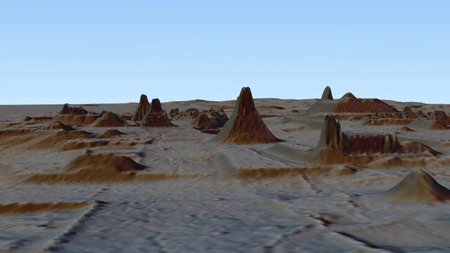
What is now dense forest, is now revealed to have been temples, roads, canals and even Mayan fortresses. Lidar scanning by aircraft just 2000 feet
above the forest reveals a hidden civilisation of high density for it's time.
www.nytimes.com...
www.nytimes.com...
originally posted by: stormcell
What is now dense forest, is now revealed to have been temples, roads, canals and even Mayan fortresses. Lidar scanning by aircraft just 2000 feet above the forest reveals a hidden civilisation of high density for it's time.
www.nytimes.com...
More than 1 thread on subject here going back 3-4 yrs. Search them out..LIDAR/ATS..either Google or ATS
Just searched..208 search results...and 3/4 of those threads here ATS
a reply to: mysterioustranger
This is a new study published in Science. It's being reported all over.
Ancient lowland Maya complexity as revealed by airborne laser scanning of northern Guatemala
This is a new study published in Science. It's being reported all over.
Ancient lowland Maya complexity as revealed by airborne laser scanning of northern Guatemala
Scholars first applied modern lidar technology to the lowland Maya area in 2009, focusing analysis on the immediate surroundings of individual sites. The PLI covers twice the area of any previous survey and involves a consortium of scholars conducting collaborative and complementary analyses of the entire survey region.
originally posted by: toms54
a reply to: mysterioustranger
This is a new study published in Science. It's being reported all over.
Ancient lowland Maya complexity as revealed by airborne laser scanning of northern Guatemala
Scholars first applied modern lidar technology to the lowland Maya area in 2009, focusing analysis on the immediate surroundings of individual sites. The PLI covers twice the area of any previous survey and involves a consortium of scholars conducting collaborative and complementary analyses of the entire survey region.
Videos, tv shows, articles numerous back to 2013-earlier.
Just this week on tv- Josh Gates and Expedition Unknown-Hidden Cities of the Maya...Travel Channel or A&E...also YouTube
a reply to: toms54
No those are Mayan temple's often also called Mayan Pyramid's like in this image of one.
www.crystalinks.com...
No those are Mayan temple's often also called Mayan Pyramid's like in this image of one.
www.crystalinks.com...
originally posted by: stormcell
What is now dense forest, is now revealed to have been temples, roads, canals and even Mayan fortresses. Lidar scanning by aircraft just 2000 feet above the forest reveals a hidden civilisation of high density for it's time.
www.nytimes.com...
Again tonight: Expedition unknown/Travel Channel---Using LIDAR to uncover the lost Guatemalan city of El Mirador....less than 15-20% exposed, but hundreds of structures from miles and miles of jungle
edit on 2-10-2018 by mysterioustranger because: Eta
new topics
-
Judge rules president-elect Donald Trump must be sentenced in 'hush money' trial
US Political Madness: 3 hours ago -
Farmers wife
Music: 5 hours ago -
NJ Drones tied to Tesla explosion at Trump Las vegas
General Conspiracies: 6 hours ago -
New Jersey-Teachers Can Now Be Certified Without Passing Basic Reading Writing Math Testing
Education and Media: 9 hours ago
top topics
-
Matthew Livelsberger said he was being followed by FBI
Political Conspiracies: 12 hours ago, 16 flags -
Here we again... CHINA having mass outbreak of something
Diseases and Pandemics: 16 hours ago, 9 flags -
The 119th Congress has Officially Opened for Business
Mainstream News: 16 hours ago, 7 flags -
New Jersey-Teachers Can Now Be Certified Without Passing Basic Reading Writing Math Testing
Education and Media: 9 hours ago, 7 flags -
Paranoid Liberals Believe U.S. Service Members are More Dangerous than Illegal Aliens.
Social Issues and Civil Unrest: 15 hours ago, 6 flags -
How the Sikhs Deal with Muslim Grooming Gangs – Tommy Robinson
Social Issues and Civil Unrest: 14 hours ago, 6 flags -
NJ Drones tied to Tesla explosion at Trump Las vegas
General Conspiracies: 6 hours ago, 3 flags -
Farmers wife
Music: 5 hours ago, 1 flags -
Judge rules president-elect Donald Trump must be sentenced in 'hush money' trial
US Political Madness: 3 hours ago, 0 flags
active topics
-
Judge rules president-elect Donald Trump must be sentenced in 'hush money' trial
US Political Madness • 4 • : Lazy88 -
Paranoid Liberals Believe U.S. Service Members are More Dangerous than Illegal Aliens.
Social Issues and Civil Unrest • 31 • : Irishhaf -
Candidate TRUMP Now Has Crazy Judge JUAN MERCHAN After Him - The Stormy Daniels Hush-Money Case.
Political Conspiracies • 2173 • : WeMustCare -
Tesla Cybertruck Explodes in Front of Trump Hotel in Las Vegas
Mainstream News • 198 • : Mantiss2021 -
Matthew Livelsberger said he was being followed by FBI
Political Conspiracies • 63 • : BeyondKnowledge3 -
Musk calls on King Charles III to dissolve Parliament over Oldham sex grooming gangs
Mainstream News • 88 • : WeMustCare -
-@TH3WH17ERABB17- -Q- ---TIME TO SHOW THE WORLD--- -Part- --44--
Dissecting Disinformation • 3923 • : RelSciHistItSufi -
Watts home paranormal activity
Paranormal Studies • 6 • : TowmasterLG -
Congress Says the FBI is Covering Up Vital Info on the Jan 5th 2021 D.C. Pipe Bombs at RNC-DNC.
Political Conspiracies • 28 • : GotterDameron23 -
New Jersey-Teachers Can Now Be Certified Without Passing Basic Reading Writing Math Testing
Education and Media • 9 • : rickymouse
13

