It looks like you're using an Ad Blocker.
Please white-list or disable AboveTopSecret.com in your ad-blocking tool.
Thank you.
Some features of ATS will be disabled while you continue to use an ad-blocker.
share:
originally posted by: BotheLumberJack
a reply to: JustMike
I don't mind, no worries. I can't say with certainty, but with all the conspiracy's i've read here and online, It's more of a 'feeling' that something is up. Like were' close to something taking place but I can't quite place my finger on what that might be. I hope that helps. I'm very open to new ideas though, and love to hear what others think and what their ideas might entail pertaining to this.
Thank you for asking
After three years you'll realize(hopefully) that it's just normal paranoia and all of us "Conspiracy inclined" folks suffer 1-10 years of it before we realize it was just silly paranoia. the good thing is you'll learn ALOT along the way, so it's not necessarily a bad thing.
on the OP: I hope everyone stays safe and they are evacuated. I was originally worried this would affect more volcanos and lead to more eruptions, but it sounds like this particular volcano has been doing minor eruptions for years now and this is just a Major one that they aren't used to.
All cable news are either Washington political crud or "royal wedding" tripe. I hate cable news sites. Nothing but propagandist brainwashing sites.
originally posted by: BotheLumberJack
a reply to: stonerwilliam
Phage is a demi god, he's fine.
Perhaps, this volcano is a product of his demi-god powers? Maybe, he's angry with the world and expressing his anger through violent volcanic activity.
Maybe he is the bastard son of Hephaestus??? Hephagestus!!
a reply to: PsychoEmperor
Yes it’s been erupting for about 30 odd years I think.
Doesn’t seem they panic over it too much.
Yes it’s been erupting for about 30 odd years I think.
Doesn’t seem they panic over it too much.
edit on 17-5-2018 by violet because: (no reason given)
Kilauea volcano has erupted from its summit around 4 am HST, sending a dusty plume of ash and smoke about 30,000 feet into the sky - via AP
www.cnn.com...
/
...At any time, activity may again become more explosive, increasing the intensity of ash production and producing ballistic projectiles near the vent," the USGS said. "Ballistic projectiles may be produced should steam-driven explosions occur. Impacts will be limited to an area around Halemaumau."
Halemaumau is the crater within Kilauea's summit caldera.
Nearby residents are being asked to shelter in place if they are in the path of the ash plume, which the wind is carrying to the northeast of the volcano, the USGS said.....
www.cnn.com...
edit on 17-5-2018 by violet because: (no reason given)
edit
on 17-5-2018 by violet because: (no reason given)
edit on 17-5-2018 by violet because: (no reason given)
]KILAUEA SUMMIT
Explosive eruption of ash this morning. Additional explosions possible at any time.
Just after 4 am this morning, an explosion or series of explosions from the Overlook vent within Halemaumau crater at Kilauea Volcano's summit produced a volcanic cloud that reached as high as 30,000 ft asl based on NWS radar information. The cloud drifted generally northeast and traces of ash fell with rain in the Volcano Golf Course, Volcano Village, and other areas immediately around the Kilauea summit.
At this time, based on HVO web cameras, a robust plume of gas, steam, and some ash is billowing out of the Overlook vent and drifting generally southwest.
At any time, activity may again become more explosive, increasing the intensity of ash production and producing ballistic projectiles very near the vent. Communities downwind should be prepared for ashfall as long as this activity continues.
Resources on volcanic ash hazards and preparedness information: volcanoes.usgs.gov... OR www.ivhhn.org...
Resources on vog: vog.ivhhn.org...
/
edit on 17-5-2018 by violet because: (no reason given)
edit on 17-5-2018 by violet because: (no reason
given)
edit on 17-5-2018 by violet because: (no reason given)
originally posted by: wylekat
a reply to: VariableConstant
So.... what happens if this thing blows its top, and things go completely upside down?
Not gonna happen, at least not in the way that you mean.
The lava is flowing in a very small area, and it definitely is a bad situation for those that live in that area. We are sheltering and feeding them as best we can. All across the Big Island, we are donating and contributing to those affected; we take care of each other out here.
If it gets worse, we'll deal with that as it comes.
a reply to: Assassin82
It's actually a goddess. Her name is Pele.
Interesting part of the legend. She moved from island to island, west to east. This follows the track of the islands away from the hot spot which created them.
Of course, the erosion of the islands make it quite obvious which are older. Never pass up a chance to create a legend.
edit on 5/18/2018 by Phage because: (no reason given)
a reply to: Phage
They have a lot of legends there, like don’t bring rocks back from Hawaii, or you bring back a curse. They say ( and I don’t know if this is true) that people mail them back. I stole sand, I put it in a water bottle and lied to customs when asked if I brought back anything of that nature. I did end up tossing it away though. Sad you can’t bring home the leis (sp?)
They have a lot of legends there, like don’t bring rocks back from Hawaii, or you bring back a curse. They say ( and I don’t know if this is true) that people mail them back. I stole sand, I put it in a water bottle and lied to customs when asked if I brought back anything of that nature. I did end up tossing it away though. Sad you can’t bring home the leis (sp?)
edit on 19-5-2018 by violet because: (no reason
given)
edit on 19-5-2018 by violet because: (no reason given)
edit on 19-5-2018 by violet because: (no reason
given)
a reply to: VariableConstant
Heard they were evacuating large portions of the area due to new lava flows blocking escape routes.
Can you verify this, and/or add anything?
Heard they were evacuating large portions of the area due to new lava flows blocking escape routes.
Can you verify this, and/or add anything?
First ever double post.
I invite you to enjoy the Waipio Valley sunset to your left.
I invite you to enjoy the Waipio Valley sunset to your left.
edit on 21-5-2018 by VariableConstant because: double down
originally posted by: Chickensalad
a reply to: VariableConstant
Heard they were evacuating large portions of the area due to new lava flows blocking escape routes.
Can you verify this, and/or add anything?
The lava flow reached the sea Saturday night, which causes a whole different type of airborne hazard, basically glass like shards.
The area between the previous outbreaks and the ocean is relatively uninhabited, so I've not heard of large portions of the area being evacuated. There are a couple neighborhoods in the Kalapana area that are probably suffering from the sulfur and laze, so people have left there.
As far as mandatory evacuations though, I've not heard announcements about it. The county civil defense agency is very good about putting out updates on the local radio stations.
edit on 21-5-2018 by VariableConstant because: (no reason given)
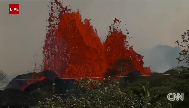
A HUGE lava fountain live on cnn:
www.cnn.com...://
Watch it while you can!
You don't see that every day!
I don't think I ever have seen anything like that...
Here is a screen shot.
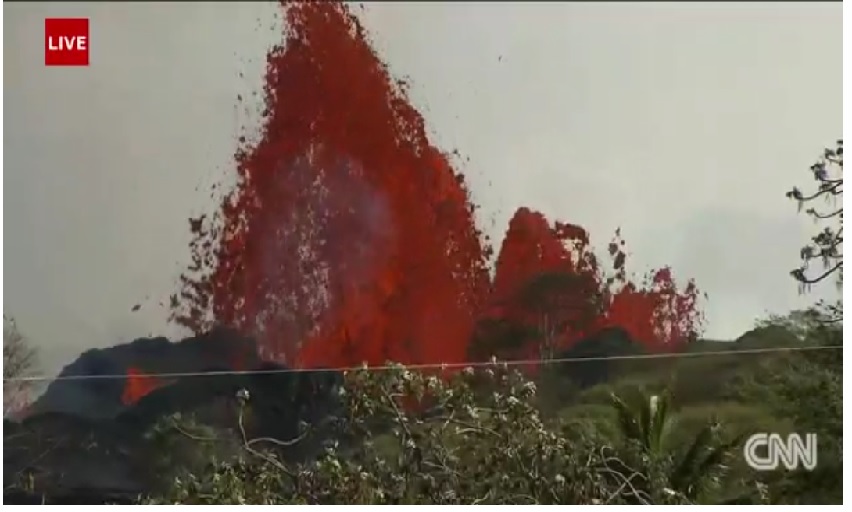
www.cnn.com...://
Watch it while you can!
You don't see that every day!
I don't think I ever have seen anything like that...
Here is a screen shot.

a reply to: Darkblade71
Wow, that is impressive for sure.
Guess that's the newer, thinner lava. The previous flows weren't shooting out like that.
Wow, that is impressive for sure.
Guess that's the newer, thinner lava. The previous flows weren't shooting out like that.
edit on 21-5-2018 by VariableConstant because: (no
reason given)
the Lava is flowing faster & hotter than expected...
I seen this headline:
in various posts made by myself
I have spoken of Hawaii & the eastern half of the ring-of-fire in Asia... along with the south American section of the west part of the ring-of-fire having exceptionally hot magma under hot-spots/volcano's... and that is what's causing so much activity starting some 20 years ago and continually producing more lava activity and more energetic EQs & Eruptions in divers places (biblical phraseintentional)
not trying to excite doom-porn...but
i hold to my stance that the ultra hot mantle under Hawaii is steady eroding the underside of the crustal plate beneath the Volcano mountain...thereby making the hot-spot even more treacherous for a localized collapse of the Big Island Itself into the pit that will replace the mountain-island Volcano that now has some 20+ new vents laying down billions of tons of new Lava on top of the older land created from past volcanic land building...
there is some ratio where the new weight of the mountain-volcano cannot be sustained by the ever eroding crustal plate support underneath the Island itself....
perhaps the GPS sensors will reveal that the Big-Island is sinking... but in reality the land is becoming more elastic and stretching downward because of the now thinner crust & heavier weight of the landmass above the waterline/tideline
i dread to think that the Volcano would sink into the Sea...to plug up the mid-Pacific hotspot from ever building any more of the long term island chain...and an undersea volcano would result to help vaporise the Fukushima radiated Pacific Ocean
I seen this headline:
Hawaiian Volcano Observatory geologists say the lava fountaining from fissure no. 8 is the hottest they've ever detected in this eruption …
in various posts made by myself
I have spoken of Hawaii & the eastern half of the ring-of-fire in Asia... along with the south American section of the west part of the ring-of-fire having exceptionally hot magma under hot-spots/volcano's... and that is what's causing so much activity starting some 20 years ago and continually producing more lava activity and more energetic EQs & Eruptions in divers places (biblical phraseintentional)
not trying to excite doom-porn...but
i hold to my stance that the ultra hot mantle under Hawaii is steady eroding the underside of the crustal plate beneath the Volcano mountain...thereby making the hot-spot even more treacherous for a localized collapse of the Big Island Itself into the pit that will replace the mountain-island Volcano that now has some 20+ new vents laying down billions of tons of new Lava on top of the older land created from past volcanic land building...
there is some ratio where the new weight of the mountain-volcano cannot be sustained by the ever eroding crustal plate support underneath the Island itself....
perhaps the GPS sensors will reveal that the Big-Island is sinking... but in reality the land is becoming more elastic and stretching downward because of the now thinner crust & heavier weight of the landmass above the waterline/tideline
i dread to think that the Volcano would sink into the Sea...to plug up the mid-Pacific hotspot from ever building any more of the long term island chain...and an undersea volcano would result to help vaporise the Fukushima radiated Pacific Ocean
I scanned this recent article:
strangesounds.org...
to this layman... It is quite clear to myself and others... the EQs are because deep under the Mountain and Lava Lake in the crater....
the Magma Chamber of Kilauea is increasing in size as the extra hot Magma is eroding the rock that was containing-the-Magma
The Mantle Plume that injects hot molten rock into the Magma Chamber under Kilauea has also increased in size -- which causes stresses on the underlying seafloor...
It is not hard to visualize that the Mauna Loa hot-spot is relocating to the Kilauea Volcano lower East Rift Zone and even more southern ocean seamount...
As the hot-spot migrates and continues in Island Building...i see a constant eruption & Lava flow scenario for months and perhaps even Years---->
the Island might even Develop to look like the Island Nation of Cuba in the near future rather than just a several cone, near roundish Island that we are accustomed seeing on Maps...
WoW a 300 mile long Island Building phase... that would be remarkable
" Hawaii is rumbling: More than 12,000 earthquakes hit Big Island over the last 30 days"
By Strange Sounds - Jun 8, 2018
strangesounds.org...
to this layman... It is quite clear to myself and others... the EQs are because deep under the Mountain and Lava Lake in the crater....
the Magma Chamber of Kilauea is increasing in size as the extra hot Magma is eroding the rock that was containing-the-Magma
The Mantle Plume that injects hot molten rock into the Magma Chamber under Kilauea has also increased in size -- which causes stresses on the underlying seafloor...
It is not hard to visualize that the Mauna Loa hot-spot is relocating to the Kilauea Volcano lower East Rift Zone and even more southern ocean seamount...
As the hot-spot migrates and continues in Island Building...i see a constant eruption & Lava flow scenario for months and perhaps even Years---->
the Island might even Develop to look like the Island Nation of Cuba in the near future rather than just a several cone, near roundish Island that we are accustomed seeing on Maps...
WoW a 300 mile long Island Building phase... that would be remarkable
edit on th30152863484310472018 by St Udio because: (no reason given)
here's a visual aid for whom-ever is following this thread...
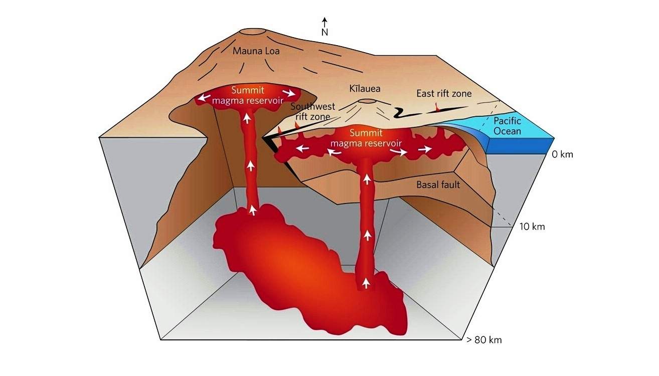
i wish the USGS had a graphic which connects the offshore, sea bottom volcanic seamount cone and the feeder chamber or vent supplying It... so one can better visualize the underground plumbing that is likely to continue Island building for every day of the next decade or more in time

i wish the USGS had a graphic which connects the offshore, sea bottom volcanic seamount cone and the feeder chamber or vent supplying It... so one can better visualize the underground plumbing that is likely to continue Island building for every day of the next decade or more in time
a reply to: St Udio
Probably not likely to get anything to detailed until they are able to place instrumentation directly on the mount:
Here are a couple of related graphics:
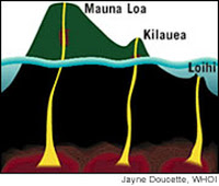
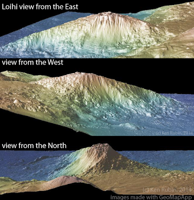
Source for above graphics and excerpt.
Here is another paper which shows the relationship of the other Hawaiian volcanoes to Lo'ihi:
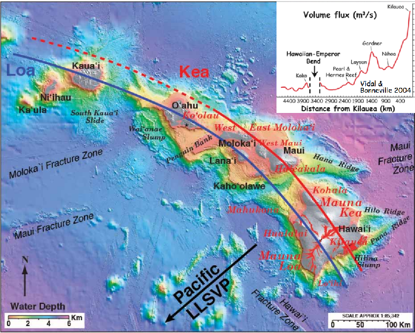
A Finer Structure of the
Hawaiian Mantle Plume: Relation
to the Earth’s deep mantle - (direct .pdf link)
Lots of other great graphics and information in that paper too.
i wish the USGS had a graphic which connects the offshore, sea bottom volcanic seamount cone and the feeder chamber or vent supplying It... so one can better visualize the underground plumbing that is likely to continue Island building for every day of the next decade or more in time
Probably not likely to get anything to detailed until they are able to place instrumentation directly on the mount:
Without permanent seismic stations at Lō‘ihi—because the highest point of the volcano is still a kilometer (0.6 mi) under water—it is not possible to locate earthquakes there as accurately as at Kīlauea or Mauna Loa. However, HVO can state that the June 2017 earthquakes appear to be clustered roughly 10–12 km (6–7 mi) below sea level and extend from beneath the summit region of Lō‘ihi to the south.
Here are a couple of related graphics:


Source for above graphics and excerpt.
Here is another paper which shows the relationship of the other Hawaiian volcanoes to Lo'ihi:

A Finer Structure of the
Hawaiian Mantle Plume: Relation
to the Earth’s deep mantle - (direct .pdf link)
Lots of other great graphics and information in that paper too.
new topics
-
Orbs Appear And Form Triangle On Live Cam.
Aliens and UFOs: 25 minutes ago -
Biden Has New Bizarre Injuries to His Face
Politicians & People: 1 hours ago -
Something is not adding up in regards to the H-1B commotion
General Conspiracies: 2 hours ago -
Elon Musk Calls for Tommy Robinson to be Freed - and Takes a Dig at Starmer
Politicians & People: 2 hours ago -
Biden to award Presidential Citizens Medal to Liz Cheney and Bennie Thompson
US Political Madness: 3 hours ago -
Just learned a really helpful trick for internet searches
Computer Help: 8 hours ago -
Not off to a good start
General Chit Chat: 10 hours ago
top topics
-
Biden Has New Bizarre Injuries to His Face
Politicians & People: 1 hours ago, 8 flags -
If they can see...they can read!!
Rant: 17 hours ago, 7 flags -
Just learned a really helpful trick for internet searches
Computer Help: 8 hours ago, 7 flags -
Not off to a good start
General Chit Chat: 10 hours ago, 6 flags -
Biden to award Presidential Citizens Medal to Liz Cheney and Bennie Thompson
US Political Madness: 3 hours ago, 5 flags -
Elon Musk Calls for Tommy Robinson to be Freed - and Takes a Dig at Starmer
Politicians & People: 2 hours ago, 5 flags -
Something is not adding up in regards to the H-1B commotion
General Conspiracies: 2 hours ago, 4 flags -
Orbs Appear And Form Triangle On Live Cam.
Aliens and UFOs: 25 minutes ago, 0 flags
active topics
-
Tesla Cybertruck Explodes in Front of Trump Hotel in Las Vegas
Mainstream News • 94 • : WeMustCare -
Ukraine halts transit of Russian gas to Europe after a prewar deal expired
Political Conspiracies • 108 • : VictorVonDoom -
Something is not adding up in regards to the H-1B commotion
General Conspiracies • 26 • : charlest2 -
-@TH3WH17ERABB17- -Q- ---TIME TO SHOW THE WORLD--- -Part- --44--
Dissecting Disinformation • 3890 • : Thoughtful3 -
Trump's idea to make Canada the 51st US state: 'Potential is massive'
Mainstream News • 150 • : Oldcarpy2 -
Orbs Appear And Form Triangle On Live Cam.
Aliens and UFOs • 0 • : alldaylong -
Biden Has New Bizarre Injuries to His Face
Politicians & People • 4 • : nugget1 -
Elon Musk Calls for Tommy Robinson to be Freed - and Takes a Dig at Starmer
Politicians & People • 8 • : BedevereTheWise -
The C.D.C. Says There Was NO INFLUENZA Worth Reporting for the 2020-2021 Flu Season.
Diseases and Pandemics • 95 • : BedevereTheWise -
Biden to award Presidential Citizens Medal to Liz Cheney and Bennie Thompson
US Political Madness • 9 • : WeMustCare

