It looks like you're using an Ad Blocker.
Please white-list or disable AboveTopSecret.com in your ad-blocking tool.
Thank you.
Some features of ATS will be disabled while you continue to use an ad-blocker.
share:
Hmm what about surveying GPS units? They require precise frequencies I think. Does that mean those businesses are SOL during the blackout?
a reply to: NightFlight
No. They still have VOR but they're starting to phase those out as well since they're going to more or less free navigation.
No. They still have VOR but they're starting to phase those out as well since they're going to more or less free navigation.
originally posted by: Zaphod58
a reply to: SkeptiSchism
Only if they're airborne. Ground units won't be affected.
How will the satellites ascertain what is a ground unit and what is airborne?
a reply to: Zaphod58
Garmin 600's and Garmin 1000's...filling the glass flight decks these days...glass cockpit
nice of ya to keep us all replied....cool of ya
:
Garmin 600's and Garmin 1000's...filling the glass flight decks these days...glass cockpit
nice of ya to keep us all replied....cool of ya
:
edit on 27-1-2018 by GBP/JPY because: (no reason given)
edit on 27-1-2018 by GBP/JPY because: (no reason given)
Maybe, or the other way around.....I'm a good helper Zaph....no i'm not....
a reply to: SkeptiSchism
a reply to: SkeptiSchism
edit on 27-1-2018 by GBP/JPY because: (no reason given)
edit on 27-1-2018 by GBP/JPY because: (no reason given)
a reply to: Zaphod58
Nevermind,
Found the link in the article and it answered my question.👍
-----------------------------------------------------------------------------------------------------------------------------------------------
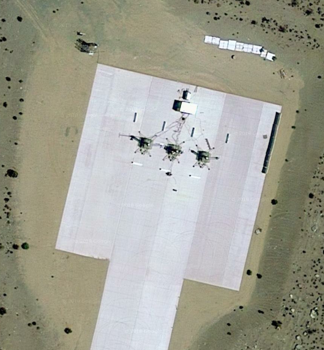
Is this jamming system mobile or static. And is it based at china lake?
Is this it?
36.1324944, -117.5314168

edit on 27-1-2018 by Bigburgh because: (no reason given)
edit on 27-1-2018 by Bigburgh because:
(no reason given)
a reply to: SkeptiSchism
Yes. Think of it as an upside down wedding cake. On the ground, unless you're right next to it, you won't notice it. At 50 feet, it jams a couple miles on either side. At 50, 000 it reaches all the way to Baja.
Yes. Think of it as an upside down wedding cake. On the ground, unless you're right next to it, you won't notice it. At 50 feet, it jams a couple miles on either side. At 50, 000 it reaches all the way to Baja.
They weren't kidding when they said Red Flag 18-1 was going to be incredibly realistic. Heh.
www.abovetopsecret.com...
www.abovetopsecret.com...
originally posted by: VengefulGhost
didnt know that never used gps . on the occasions need to navigate use good old fashioned map and compass .
hence figured the gps outage would effect all the electronic gizmos people rely on to navigate these days .
GPS signals are sent in the microwave band, at about 1600 MHz. The other radio navigation aids include VOR/TAC in the VHF band and non-directional ADF beacons in the low frequency band. And sophisticated civilian aircraft can have non radio nav systems like inertial navigation systems. You can even do some non precision navigation using onboard weather radar. Just adjust the tilt down and it will paint large lakes, coastlines, etc. Plus, at 41,000 feet you can see just short of 300 miles so you can see major cities a long way away, particularly at night.
originally posted by: jimmyx
originally posted by: Zaphod58
a reply to: VengefulGhost
They don't affect ground level or low altitude. It's only high and medium altitudes that will be affected.
with all due respect, zap, why don't they turn off the GPS of the individual craft involved in the exercise?.....the amount of possible accidental harm from this wide area shutdown would seem to make this problematic.
Simple answer is it wouldn't be a test. What they will do is deploy low-cost jammers placed at the right location to wreak havoc with incoming GPS signals, which are often quite weak. So part of it will be to detect those jammers as well as circumvent them.
www.army.mil...
edit on 1/27/18 by dragonridr because: (no reason
given)
This would seem to be an acknowledgement China,Russia or maybe even North Korea can jam GPS
a reply to: khnum
Someone at the Pentagon forgot to have their mandatory lobotomy and realized we might want to relearn how to go low tech, just in case. It's less that they can jam it, and more that satellites, especially GPS satellites, are going to be a major target if a near peer war were to happen.
Someone at the Pentagon forgot to have their mandatory lobotomy and realized we might want to relearn how to go low tech, just in case. It's less that they can jam it, and more that satellites, especially GPS satellites, are going to be a major target if a near peer war were to happen.
a reply to: Zaphod58
Things are getting unstable in so many areas its not like the old days of the Mustang 16000 plus built at $630000 a piece in todays money in short order I sure hope you got enough planes.
Things are getting unstable in so many areas its not like the old days of the Mustang 16000 plus built at $630000 a piece in todays money in short order I sure hope you got enough planes.
edit on 27-1-2018 by khnum because: (no reason given)
originally posted by: misterhistory
I don’t recall but would cell phones not be impeded even if was at all altitudes? I thought they used cell towers for gps coordinates without gps satellite help?
GPS is purely satellite based,so if they use cell towers it won't be GPS.They can triangulate from adjacent cell towers and work out a rough location (to within about 100 metres) based on relative signal strengths,but because the aerials aren't directional it can never be all that accurate.
The handset can also send back GPS based location data to the cell tower without the user even knowing it,giving location accuracies to within a couple of metres.
They can even use wi-fi signals the phone picks up that always have some sort of identifier attached to the signal,this can localise you to within range of that particular wi-fi unit.
new topics
-
Search to Resume for MH 370
Disaster Conspiracies: 1 hours ago -
Sue Gray, Sir Keir Starmer's former Chief of Staff, Nominated for Peerage
Regional Politics: 3 hours ago -
Biden Nationalizes Another 50,000+ Student Loans as He Heads for the Exit
US Political Madness: 4 hours ago
top topics
-
An Interesting Conversation with ChatGPT
Science & Technology: 13 hours ago, 7 flags -
Biden Nationalizes Another 50,000+ Student Loans as He Heads for the Exit
US Political Madness: 4 hours ago, 6 flags -
Sue Gray, Sir Keir Starmer's former Chief of Staff, Nominated for Peerage
Regional Politics: 3 hours ago, 2 flags -
Search to Resume for MH 370
Disaster Conspiracies: 1 hours ago, 2 flags
active topics
-
US Federal Funding set to Expire December 20th. Massive CR on the way.
Mainstream News • 44 • : burntheships -
-@TH3WH17ERABB17- -Q- ---TIME TO SHOW THE WORLD--- -Part- --44--
Dissecting Disinformation • 3766 • : 777Vader -
Biden Nationalizes Another 50,000+ Student Loans as He Heads for the Exit
US Political Madness • 3 • : Flyingclaydisk -
Search to Resume for MH 370
Disaster Conspiracies • 2 • : Flyingclaydisk -
Can someone 'splain me like I'm 5. Blockchain?
Science & Technology • 88 • : Flyingclaydisk -
Russias War Against Religion in Ukraine
World War Three • 53 • : Oldcarpy2 -
An Interesting Conversation with ChatGPT
Science & Technology • 20 • : randomuser2034 -
Squirrels becoming predators
Fragile Earth • 33 • : Oldcarpy2 -
Why isn't Psychiatry involved?
Social Issues and Civil Unrest • 26 • : lilzazz -
Mood Music Part VI
Music • 3748 • : ChaoticOrder

