It looks like you're using an Ad Blocker.
Please white-list or disable AboveTopSecret.com in your ad-blocking tool.
Thank you.
Some features of ATS will be disabled while you continue to use an ad-blocker.
share:
a reply to: olaru12
Yea, anybody outside upon initial impact will be having the live experience of the Wizard of Oz. Hopefully nobody gets Gone With the Wind.
It can hold you up as you lean into up to a 2. After that your likely to be flying though if you still try to go outside.
Lots of people always just go outside if its under 100mph and play games with the wind. The projectiles are still not too bad at under that. Once it gets stronger though their are missiles flying all ready to impale, and people themselves can go airborne.
Have not seen that yet though, because most of us know to stay indoors once it passes 100.
a reply to: worldstarcountry
Sorry if someone already brought this, too funny...
Lots of people always just go outside if its under 100mph and play games with the wind. The projectiles are still not too bad at under that
Sorry if someone already brought this, too funny...
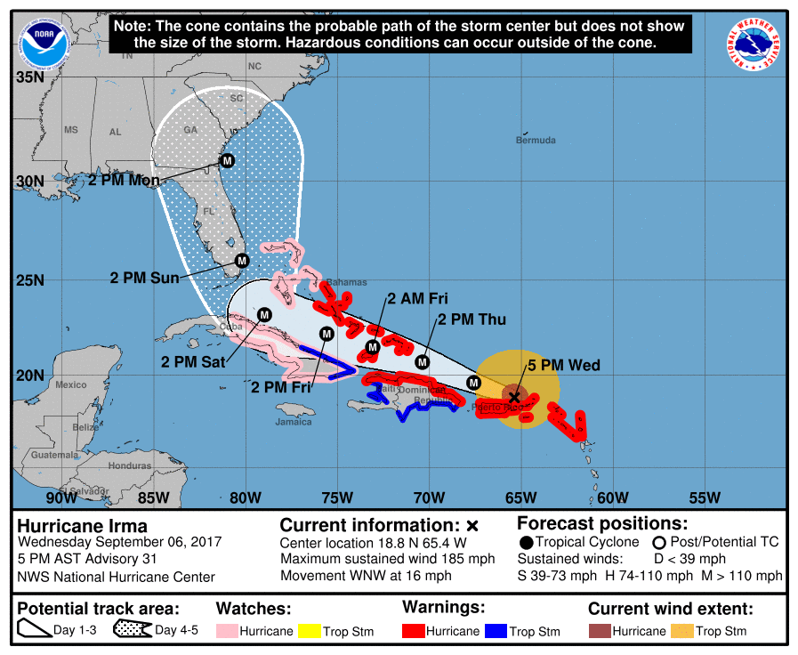
The National Weather Service is projecting that Irma will make a hard right turn and slam into Miami.
Don't really powerful hurricanes tend to resist wind steering currents? I'm thinking that Irma is more like an aircraft carrier. It will turn right/north, but not on a dime, like the NWS is projecting.
Don't really powerful hurricanes tend to resist wind steering currents? I'm thinking that Irma is more like an aircraft carrier. It will turn right/north, but not on a dime, like the NWS is projecting.
originally posted by: carewemust
The National Weather Service is projecting that Irma will make a hard right turn and slam into Miami.
Don't really powerful hurricanes tend to resist wind steering currents? I'm thinking that Irma is more like an aircraft carrier. It will turn right/north, but not on a dime, like the NWS is projecting.
It's depending on how it interacts with Cuba. If it goes over high terrain there, the land will weaken it, but yes Miami is not looking good. Category strength is all about wind, so it's the storm surge that's of concern near the water.
Irma update:
Irma remains a cat 5 with very powerful winds, rarely this strength.
6:00 PM AST Wed Sep 6
Location: 18.9°N 65.6°W
Moving: WNW at 16 mph
Min pressure: 914 mb
Max sustained: 185 mph

DISCUSSION AND 48-HOUR OUTLOOK
------------------------------
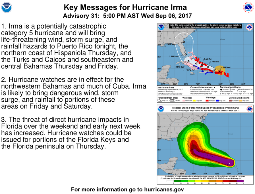
At 500 PM AST (2100 UTC), the eye of Hurricane Irma was located
near latitude 18.8 North, longitude 65.4 West. Irma is moving
toward the west-northwest near 16 mph (26 km/h), and this general
motion is expected to continue for the next couple of days. On the
forecast track, the extremely dangerous core of Irma will pass just
north of Puerto Rico tonight, pass near or just north of the coast
of Hispaniola Thursday, and be near the Turks and Caicos and
southeastern Bahamas by Thursday evening.
Maximum sustained winds are near 185 mph (295 km/h) with higher
gusts. Irma is a category 5 hurricane on the Saffir-Simpson
Hurricane Wind Scale. Some fluctuations in intensity are likely
during the next day or two, but Irma is forecast to remain a
powerful category 4 or 5 hurricane during the next couple of days.
Hurricane-force winds extend outward up to 50 miles (85 km) from the
center and tropical-storm-force winds extend outward up to 185 miles
(295 km). A wind gust to 62 mph (100 km/h) has been recently
reported at San Juan, Puerto Rico.
The estimated minimum central pressure based on Air Force
reconnaissance aircraft data is 914 mb (26.99 inches).
Irma remains a cat 5 with very powerful winds, rarely this strength.
6:00 PM AST Wed Sep 6
Location: 18.9°N 65.6°W
Moving: WNW at 16 mph
Min pressure: 914 mb
Max sustained: 185 mph
edit on 6-9-2017 by violet because: (no reason given)

edit on 6-9-2017 by violet because: (no reason given)
DISCUSSION AND 48-HOUR OUTLOOK
------------------------------
At 500 PM AST (2100 UTC), the eye of Hurricane Irma was located
near latitude 18.8 North, longitude 65.4 West. Irma is moving
toward the west-northwest near 16 mph (26 km/h), and this general
motion is expected to continue for the next couple of days. On the
forecast track, the extremely dangerous core of Irma will pass just
north of Puerto Rico tonight, pass near or just north of the coast
of Hispaniola Thursday, and be near the Turks and Caicos and
southeastern Bahamas by Thursday evening.
Maximum sustained winds are near 185 mph (295 km/h) with higher
gusts. Irma is a category 5 hurricane on the Saffir-Simpson
Hurricane Wind Scale. Some fluctuations in intensity are likely
during the next day or two, but Irma is forecast to remain a
powerful category 4 or 5 hurricane during the next couple of days.
Hurricane-force winds extend outward up to 50 miles (85 km) from the
center and tropical-storm-force winds extend outward up to 185 miles
(295 km). A wind gust to 62 mph (100 km/h) has been recently
reported at San Juan, Puerto Rico.
The estimated minimum central pressure based on Air Force
reconnaissance aircraft data is 914 mb (26.99 inches).
edit on 6-9-2017 by violet because: (no reason given)
originally posted by: carewemust
The National Weather Service is projecting that Irma will make a hard right turn and slam into Miami.
Don't really powerful hurricanes tend to resist wind steering currents? I'm thinking that Irma is more like an aircraft carrier. It will turn right/north, but not on a dime, like the NWS is projecting.
That area has been known as a push-pull for many hurricanes. It can make them stall and whip off in wild directions. I sure hope it can just keep turning that bastard out to a safe distance where colder water will rip it apart.
a reply to: carewemust
It's moving west because of the pressure ridge in the Atlantic that it is moving around.
Normally they cross into the westerlies from the trades and move west with a drift toward the pole.
The north turn is a normal situation. You notice how many that form a bit farther north do not make the east coast.
Where it makes landfall in Florida is still uncertain
I just got home so I'm not up to speed on evacuation orders that may be in place
I think they are waiting to see where landfall will be. Waiting on it getting near Cuba. Looking like a weekend hit though.
So I am wondering if this means crucial evacuations might be held off because clearly you cannot tell EVERYONE to get out of the way due to the logistics of doing that, with gas supplies , roads jamming etc. I fear people might not be told early enough, as they wait to tell one area and then the roads will be busy getting out still. People of course will choose to stay. People near the water should get the # out now!
a reply to: intrptr
HA! That was funny. The subject of his dialogue attempted to stay out in a cat 3 like a fool. I said above a 2 and you better not be outside. 100mph or under you will still be fine if you just stay alert. The auto's dont start to get kicked around until about 115 -120 when the gusts are even higher. Either way, thats why our plan is to park the cars in the parking garage against a wall that happens o be right behind my parents house IF we are exposed to the real fury.
In fact, Im going to make my prediction right now. It will make landfall between Marcos Island and Everglades city and continue across the Gulf towards anywhere from Mississippi to Texas. That is my official prediction and I won't revise it either due to any updates. If im wrong im wrong.
originally posted by: charlyv
originally posted by: carewemust
The National Weather Service is projecting that Irma will make a hard right turn and slam into Miami.
Don't really powerful hurricanes tend to resist wind steering currents? I'm thinking that Irma is more like an aircraft carrier. It will turn right/north, but not on a dime, like the NWS is projecting.
That area has been known as a push-pull for many hurricanes. It can make them stall and whip off in wild directions. I sure hope it can just keep turning that bastard out to a safe distance where colder water will rip it apart.
That's what I'm hoping will happen to IRMA and also JOSE. Jose is following behind IRMA and just became a hurricane, a couple hours ago.
originally posted by: roadgravel
a reply to: carewemust
It's moving west because of the pressure ridge in the Atlantic that it is moving around.
Normally they cross into the westerlies from the trades and move west with a drift toward the pole.
The north turn is a normal situation. You notice how many that form a bit farther north do not make the east coast.
Hurricane KATIA formed in the southern Gulf of Mexico today. It's drifting south at 3mph.
www.abcactionnews.com...
Hopefully the north turn you reference, will not happen to Katia!
Low vertical wind shear and warm waters along the forecast track of
Irma should allow it to remain a very powerful hurricane during the
next several days, and the intensity forecast is again near the
upper-end of the guidance and is the same as the previous advisory
through 96 hours. Increasingly southwesterly shear and potential
land interaction late in the period is expected to cause some
decrease in Irma's strength by day 5.
Efforts to provide the forecast models with as much data as possible
continue, with 6-hourly NWS balloon launches across much of the
continental United States, and the NOAA G-IV aircraft currently
sampling the environment around the storm.
www.wunderground.com...
The models have been quite accurate this season.
a reply to: worldstarcountry
If a volvo is floating at ten miles per hour and you get in its way...
game over.
The auto's dont start to get kicked around until about 115 -120 when the gusts are even higher.
If a volvo is floating at ten miles per hour and you get in its way...
game over.
Jose looks to be following Irma's path and looking to become a major hurricane
Katia looks better, it's staying close to Mexico
Katia looks better, it's staying close to Mexico
originally posted by: DontTreadOnMe
a reply to: Nickn3
If you are familiar with the area, are there any concerns that the bridge system in the Keys is in any danger?
Good question.
Never thought about that.
a reply to: carewemust
As long as that ridge builds, it should keep it south so it moves west into land. Central - EastTexas doesn't need another hit.
Hopefully it will not gain a lot of strength.
The hurricane is
forecast to meander in the southwestern Gulf of Mexico for the next
day or two. After that time the global models develop a ridge over
the northern Gulf of Mexico and this flow pattern will steer Katia
southwestward toward the state of Veracruz
www.wunderground.com...
As long as that ridge builds, it should keep it south so it moves west into land. Central - EastTexas doesn't need another hit.
Hopefully it will not gain a lot of strength.
originally posted by: worldstarcountry
a reply to: NightSkyeB4Dawn
There is only one single route that storm can take to hit the city i live in as a cat3+ , and most the model do not show it taking that route. By the time it makes it here, it will only be a 1 or 2 tops, if that. We have ridden out plenty of those. In fact there is a sport we enjoy called go out to the water and lean into the wind as it holds you up.
My concern is the jackasses that migrate out from east of Nebraska avenue and into other parts of the city to break into homes and cars when people have left entire neighborhoods empty. happens every time a storm like this approaches.
I imagine that's another reason not wanting to flee your home. Then of course those staying might be planning to loot
new topics
-
Never say Never?
Science & Technology: 2 hours ago -
Lies lies lies, green energy is black.
The Gray Area: 9 hours ago
top topics
-
Biden pardons his son Hunter despite previous pledges not to
Mainstream News: 17 hours ago, 20 flags -
President Biden pardons his son Hunter Biden
US Political Madness: 17 hours ago, 11 flags -
Lies lies lies, green energy is black.
The Gray Area: 9 hours ago, 9 flags -
Never say Never?
Science & Technology: 2 hours ago, 6 flags -
Ford Motor Company sold to Elon Musk
Ludicrous Online Lies: 13 hours ago, 1 flags
active topics
-
Biden pardons his son Hunter despite previous pledges not to
Mainstream News • 80 • : nugget1 -
Never say Never?
Science & Technology • 15 • : Moon68 -
Lies lies lies, green energy is black.
The Gray Area • 18 • : CriticalStinker -
Of course it was DEI
Dissecting Disinformation • 28 • : Dalamax -
Ford Motor Company sold to Elon Musk
Ludicrous Online Lies • 9 • : whyamIhere -
-@TH3WH17ERABB17- -Q- ---TIME TO SHOW THE WORLD--- -Part- --44--
Dissecting Disinformation • 3452 • : Thoughtful3 -
I thought Trump was the existential threat?
World War Three • 184 • : cherokeetroy -
Jaguar Rebrand Video Causes "WTF?" Moment - Seriously Weird
Automotive Discussion • 38 • : gortex -
Salvatore Pais confirms science in MH370 videos are real during live stream
General Conspiracies • 32 • : Flyingclaydisk -
Post A Funny (T&C Friendly) Pic Part IV: The LOL awakens!
General Chit Chat • 7860 • : underpass61

