It looks like you're using an Ad Blocker.
Please white-list or disable AboveTopSecret.com in your ad-blocking tool.
Thank you.
Some features of ATS will be disabled while you continue to use an ad-blocker.
share:
Considering that Mars used to be wet and warm in the past, I sometimes ask myself whether that environment could have been stable for long enough to
allow life to form and evolve. Not just microbial life, I'm thinking about more advanced forms of marine life, like stromatolites or coral
reefs, and of course whether these could have affected the terrain in such a way that it can be distinguished from other landforms via satellite
imagery?
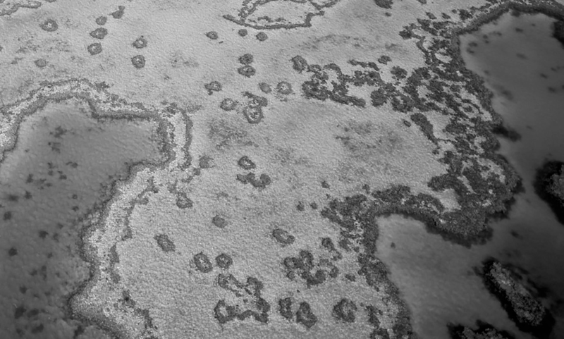
Here's a greyscale image of the Great Barrier Reef on Earth:
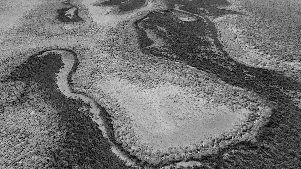
And here goes a Mars image with terrain features showing "certain" similarities:
 Source
When comparing the two images it's of course not a 100% match. But upon closer inspection there are subtle features that appear to be quite similar. It's especially the shading of the rocks and soil layers that intrigued me.
Officially, the image is labeled "North Polar Landforms" (close to the Planum Boreum region, coord.: 83.755°N 244.908°E) and such features are often described as being the result of sublimation or periglaciation. In the two images above please also note the curved segments running roughly parallel on the left hand side with a lighter streak of sand in the center (I noticed that these occur rather frequently in areas where coral reefs form, at least on Earth).
I'm quite sure that geologists would have alerted us to the existence of ancient reefs by now if they ever existed and if they were indeed identifiable in satellite imagery. But to the layperson the possibility of actually finding such remains wouldn't neccesarily seem impossible. There are probably many other areas on Mars showing a similar terrain, but I didn't have the time to do a more thorough research.
Also see thumbail below for a different perspective:
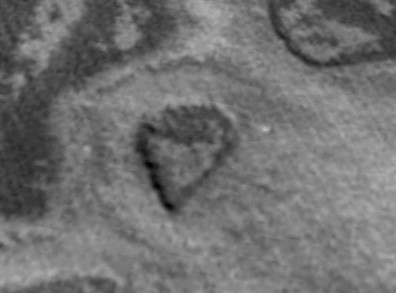
Heck, there's even a Martian analog to the so-called "Heart Reef" (Great Barrier Reef):
Earth:
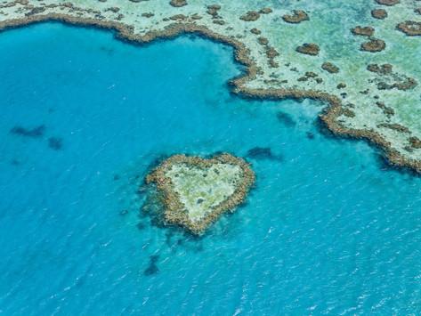
Mars:
 Click for more context
I don't think that the discoloration/shading of the terrain is due to albedo features since the same coloring/shading shows up on several images taken at different dates. Also, I'm aware that the above points are no proof of anything and that my comparisons are based on visual analysis only, but could there be a way to determine whether certain marine organisms have a lasting impact on surface morphology (eg. shading) that can be seen in aerial images?
I know this may be a far-fetched idea, but perhaps it's worth thinking about it? As always, thanks for reading up to here and I look forward to your thoughts on this...
SOURCE & LINKS:
----------------------------------------------------
01. NASA/JPL HiRISE image ESP_017886_2640
02. UNESCO: The Great Barrier Reef
03. Definition: Stromatolite
04. Wikipedia Entry for Coral Reef
05. Facts about the Great Barrier Reef
Here's a greyscale image of the Great Barrier Reef on Earth:

And here goes a Mars image with terrain features showing "certain" similarities:

When comparing the two images it's of course not a 100% match. But upon closer inspection there are subtle features that appear to be quite similar. It's especially the shading of the rocks and soil layers that intrigued me.
Officially, the image is labeled "North Polar Landforms" (close to the Planum Boreum region, coord.: 83.755°N 244.908°E) and such features are often described as being the result of sublimation or periglaciation. In the two images above please also note the curved segments running roughly parallel on the left hand side with a lighter streak of sand in the center (I noticed that these occur rather frequently in areas where coral reefs form, at least on Earth).
I'm quite sure that geologists would have alerted us to the existence of ancient reefs by now if they ever existed and if they were indeed identifiable in satellite imagery. But to the layperson the possibility of actually finding such remains wouldn't neccesarily seem impossible. There are probably many other areas on Mars showing a similar terrain, but I didn't have the time to do a more thorough research.
Also see thumbail below for a different perspective:

Heck, there's even a Martian analog to the so-called "Heart Reef" (Great Barrier Reef):
Earth:

Mars:

I don't think that the discoloration/shading of the terrain is due to albedo features since the same coloring/shading shows up on several images taken at different dates. Also, I'm aware that the above points are no proof of anything and that my comparisons are based on visual analysis only, but could there be a way to determine whether certain marine organisms have a lasting impact on surface morphology (eg. shading) that can be seen in aerial images?
I know this may be a far-fetched idea, but perhaps it's worth thinking about it? As always, thanks for reading up to here and I look forward to your thoughts on this...
SOURCE & LINKS:
----------------------------------------------------
01. NASA/JPL HiRISE image ESP_017886_2640
02. UNESCO: The Great Barrier Reef
03. Definition: Stromatolite
04. Wikipedia Entry for Coral Reef
05. Facts about the Great Barrier Reef
edit on 9-7-2017 by jeep3r because: text
These are very interesting. Good find. Could be the detritus of ancient reefs from the long-gone north Martian ocean.
Is it me, or in that photo of the Martian "heart" formation, is the "heart" in the centre of a slightly-darker ring formation? Not clear whether it is elevation or depression, or what it implies. My initial thought is that the central formation means it is unlikely to be an impact crater.
Is it me, or in that photo of the Martian "heart" formation, is the "heart" in the centre of a slightly-darker ring formation? Not clear whether it is elevation or depression, or what it implies. My initial thought is that the central formation means it is unlikely to be an impact crater.
a reply to: jeep3r
I don't think it's far fetched at all , it's believed Mars was Earthlike for 2 to 3 billion years , life on Earth started after about a billion years and arose from the seas so I see no reason it couldn't have started on Mars around that timescale in the Martian seas.
Interesting comparison shots.
I know this may be a far-fetched idea, but perhaps it's worth thinking about it?
I don't think it's far fetched at all , it's believed Mars was Earthlike for 2 to 3 billion years , life on Earth started after about a billion years and arose from the seas so I see no reason it couldn't have started on Mars around that timescale in the Martian seas.
Interesting comparison shots.
a reply to: audubon
To me it seemed to be the faint outline of a crater rim at first. Possibly an early impactor from the Noachian or Hesperian period. Or could it be the edges of an ancient reef? They apparently do tend to form circular ridges at times, but it's difficult to say.
I hope this thread will help shed some light on whether ancient reefs could leave behind traces that are visible on the macro-scale. Any further thoughts and ideas are of course welcome!
edit on 9-7-2017 by jeep3r because: text
originally posted by: gortex
a reply to: jeep3r
I don't think it's far fetched at all , it's believed Mars was Earthlike for 2 to 3 billion years , life on Earth started after about a billion years and arose from the seas so I see no reason it couldn't have started on Mars around that timescale in the Martian seas.
Interesting comparison shots.
Looks like I don't have to question my sanity after all
I wonder if anyone can provide insights about what happens when coral reefs start decaying and whether or not their former existence would leave visible traces in the overall appearance of the terrain (traces that we could make out from a distance, without "boots on the ground" so to speak).
Of course we should consider all non-biological processes at first, but it's really tempting to think there was a lush biological environment on Mars at some point.
originally posted by: jeep3r
a reply to: audubon
To me it seemed to be the faint outline of a crater rim at first. Possibly an early impactor from the Noachian or Hesperian period. Or could it be the edges of an ancient reef? They apparently do tend to form circular ridges at times, but it's difficult to say.
I hope this thread will help shed some light on whether ancient reefs could leave behind traces that are visible on the macro-scale. Any further thoughts and ideas are of course welcome!
If the water was drying up, then the coral would absorb the seawater for nutrients and let it evaporate. So they would seem to be in their own little ponds. Here's another example:
www.flickr.com...
some fascinating images.
wasn't the sun much hotter billions of years ago meaning the goldilocks zone we are in could have around mars?
can never find anything definitive as scientists aren't in the habit of making guesses.
i'm pretty sure i read somewhere a while back that we have pretty much killed off our great barrier reef.
Interesting observation, but the important lesson I took from reading about science is that if something looks like something else, it doesn't mean
they are related or have the same origin.
Even if Mars were habitable for long enough for coral polyps to evolve, could they have existed in the polar regions where it would have been quite cold anyway?
The layered formations in the polar regions are explained as the result of climate change over a long course of time: www.uahirise.org...
emphasis mine
Viewing the images at their original scale may also give you a better perspective. Here's the "curved segment" at the original image scale, at 50 cm/pixel resolution:

The light-toned band in-between the dark ones is approx 60 meters wide in the widest part seen here.
This could only vaguely be likened to coral formations; it looks more like just bedrock with layers of frost and dust.
Those polar layers certainly do look interesting.

Even if Mars were habitable for long enough for coral polyps to evolve, could they have existed in the polar regions where it would have been quite cold anyway?
The layered formations in the polar regions are explained as the result of climate change over a long course of time: www.uahirise.org...
Mars, like Earth, appears to have experienced global climate changes over the past few million years. The effects of Earth’s ice ages are well recorded in polar ice in Greenland and Antarctica. Similarly, layered deposits in both polar regions on Mars (see above) appear to record ancient Martian climate variations. Changes in the tilt (relative to the Sun) of the rotation axes of both Earth and Mars are thought to have influenced their climates, but these changes were larger in the Martian case.
For this reason and because of the apparent lack of recent oceans and life on Mars, it should be simpler to determine the causes and history of climate changes on Mars. HiRISE is returning images of the polar layered deposits on Mars that have the potential to help to unravel Mars’ climate history.
Most Mars researchers believe that the polar layered deposits are the result of variations in the amounts of dust and water ice deposited over many climate cycles, but the amount of time needed to form individual layers remains a major uncertainty. Studies of the thickness of polar layers are limited by image resolution. Are thinner layers present, but not visible in the images returned by previous Mars missions? HiRISE is expected to answer this question and better determine the thickness of layers in the polar deposits.
Analysis of HiRISE data should result in a better understanding of the timescales involved in the deposition of the layered deposits and provide important information regarding the climate history of Mars.
emphasis mine
Viewing the images at their original scale may also give you a better perspective. Here's the "curved segment" at the original image scale, at 50 cm/pixel resolution:

The light-toned band in-between the dark ones is approx 60 meters wide in the widest part seen here.
This could only vaguely be likened to coral formations; it looks more like just bedrock with layers of frost and dust.
Those polar layers certainly do look interesting.

edit on 10-7-2017 by wildespace because: (no reason given)
originally posted by: wildespace
Viewing the images at their original scale may also give you a better perspective. Here's the "curved segment" at the original image scale, at 50 cm/pixel resolution
Some good points there, wildespace, and I admit that some wishful thinking was involved here (especially when looking at the scale of the features).
However, the general question remains (to any experts out there): would it be possible to identify ancient reefs on satellite imagery? Would they decay without a trace or would they affect their immediate environment in a way that would be recognizable and make them distinguishable from other land forms?
I don't think anyone was suggesting that these formations were intact coral-like reefs, were they? Or at least, that wasn't the assumption I was
making. Clearly, it's unrealistic to expect coral-like lifeforms to still be recognisable after however many squillions of years have passed since the
Martian ocean evaporated.
As for the point about the Martian north pole being cold, I'm not sure about that. We don't know how warm Mars might have been in the past, and here on Earth we know that at one stage it was warm enough for crocodiles to live above the arctic circle. I don't think we can take much for granted about the ancient Martian climate - or even about the temperature that Martian life-forms might have found conducive.
As for the point about the Martian north pole being cold, I'm not sure about that. We don't know how warm Mars might have been in the past, and here on Earth we know that at one stage it was warm enough for crocodiles to live above the arctic circle. I don't think we can take much for granted about the ancient Martian climate - or even about the temperature that Martian life-forms might have found conducive.
a reply to: audubon
Not in terms of extant corals on the surface, I doubt anyone assumed that to be the case.
It's more the thought of whether or not ancient marine organisms, like corals or stromatolites, would have left behind any distinct large-scale patterns in the terrain that would be visible long after their demise.
I'm not sure if carbonate exoskeletons, eg. as produced by corals, would completely decay or whether these would somehow leave a sort of "signature" in the terrain (shading, discoloration, patterns etc). Also taking into account that erosion on Mars over the past 2bn years was not necessarily overwhelming, as stated by this source.
new topics
-
'Mass Casualty event' - Attack at Christmas market in Germany
Mainstream News: 1 hours ago -
Search to Resume for MH 370
Disaster Conspiracies: 3 hours ago -
Sue Gray, Sir Keir Starmer's former Chief of Staff, Nominated for Peerage
Regional Politics: 5 hours ago -
Biden Nationalizes Another 50,000+ Student Loans as He Heads for the Exit
US Political Madness: 6 hours ago
top topics
-
'Mass Casualty event' - Attack at Christmas market in Germany
Mainstream News: 1 hours ago, 15 flags -
An Interesting Conversation with ChatGPT
Science & Technology: 15 hours ago, 8 flags -
Biden Nationalizes Another 50,000+ Student Loans as He Heads for the Exit
US Political Madness: 6 hours ago, 7 flags -
Sue Gray, Sir Keir Starmer's former Chief of Staff, Nominated for Peerage
Regional Politics: 5 hours ago, 3 flags -
Search to Resume for MH 370
Disaster Conspiracies: 3 hours ago, 3 flags
active topics
-
'Mass Casualty event' - Attack at Christmas market in Germany
Mainstream News • 16 • : NorthOS -
Can someone 'splain me like I'm 5. Blockchain?
Science & Technology • 90 • : Ravenwatcher -
Russias War Against Religion in Ukraine
World War Three • 54 • : andy06shake -
Search to Resume for MH 370
Disaster Conspiracies • 3 • : chr0naut -
Drone Shooting Arrest - Walmart Involved
Mainstream News • 36 • : imitator -
-@TH3WH17ERABB17- -Q- ---TIME TO SHOW THE WORLD--- -Part- --44--
Dissecting Disinformation • 3768 • : Thoughtful3 -
Have you noticed?? Post Election news coverage...
World War Three • 10 • : chr0naut -
An Interesting Conversation with ChatGPT
Science & Technology • 21 • : Flyingclaydisk -
US Federal Funding set to Expire December 20th. Massive CR on the way.
Mainstream News • 45 • : marg6043 -
Biden Nationalizes Another 50,000+ Student Loans as He Heads for the Exit
US Political Madness • 5 • : Dalamax
