It looks like you're using an Ad Blocker.
Please white-list or disable AboveTopSecret.com in your ad-blocking tool.
Thank you.
Some features of ATS will be disabled while you continue to use an ad-blocker.
share:
Set your alarms ATS,
the launch window opens up around 330
NASA really will be "cloud seeding" or upper atmosphere spraying?
I really hope this thread sticks to the science facts but this is ATS,
and really hope we can all share and imagine the possibilities...
This should be an amazing sight to behold!
Please be kind and enjoy!
Remember, we ALL make History every day.
Get your cameras ready too!
www.cnn.com...
www.nasa.gov...< br />
the launch window opens up around 330
NASA really will be "cloud seeding" or upper atmosphere spraying?
I really hope this thread sticks to the science facts but this is ATS,
and really hope we can all share and imagine the possibilities...
This should be an amazing sight to behold!
Please be kind and enjoy!
Remember, we ALL make History every day.
Get your cameras ready too!
(CNN)If you live along the Eastern Seaboard and wake up early Sunday,
you could be treated to a colorful sky hours before sunrise.
Blue-green and red clouds could be visible in the predawn sky from New York to North Carolina,
thanks to a NASA rocket due to be launched from Wallops Flight Facility on the eastern shore of Virginia.
The Terrier-Improved Malemute sounding rocket is now scheduled for launch between 4:26 a.m. and 4:41 a.m. ET. And in this case, the rocket launch isn't even the cool part.
Four to five minutes after launch, the rocket is expected to deploy 10 canisters about the size of soft drink cans, each containing a colored vapor that forms artificial, luminescent clouds.
The sounding rocket's payload is tested at the Wallops Flight Facility. The sounding rocket's payload is tested at the Wallops Flight Facility. The clouds, or vapor tracers, are formed "through the interaction of barium, strontium, and cupric-oxide," according to NASA.
www.cnn.com...
www.nasa.gov...< br />
edit on 3-6-2017 by iWontGiveUP because: Grammar
edit on 3-6-2017 by iWontGiveUP because: Qt
a reply to: iWontGiveUP
Hey whats up with these frigging pearly clouds that hang around in the same frigging spot every god damn evening, this is the first year i have seen these- and i have seen enough of them already, making me paranoid.
Hey whats up with these frigging pearly clouds that hang around in the same frigging spot every god damn evening, this is the first year i have seen these- and i have seen enough of them already, making me paranoid.
a reply to: iWontGiveUP
Like these, but they do not move around much,,, too little, i am not claiming that this is not a natural thing, but why this spring there are so many and so often... never before... and i watch the skies like a hawk. They are pretty but i do not feel comfortable with them hanging around..
-one more edit, my paranoia will get worse if the NASA clouds will look like these...
Like these, but they do not move around much,,, too little, i am not claiming that this is not a natural thing, but why this spring there are so many and so often... never before... and i watch the skies like a hawk. They are pretty but i do not feel comfortable with them hanging around..
edit on 3-6-2017 by solve because: (no reason given)
-one more edit, my paranoia will get worse if the NASA clouds will look like these...
edit on 3-6-2017 by solve because: (no reason
given)
originally posted by: solve
a reply to: iWontGiveUP
Hey whats up with these frigging pearly clouds that hang around in the same frigging spot every god damn evening, this is the first year i have seen these- and i have seen enough of them already, making me paranoid.
Well, you know CERN started back up in April again, right?
edit on 6/3/2017 by sled735 because: correction
a reply to: iWontGiveUP
They've been doing this for years. It's the only way to be able to study the extreme upper atmosphere and see how winds start up there.
They've been doing this for years. It's the only way to be able to study the extreme upper atmosphere and see how winds start up there.
originally posted by: Zaphod58
a reply to: iWontGiveUP
They've been doing this for years. It's the only way to be able to study the extreme upper atmosphere and see how winds start up there.
Will this tell us something about how much of climate change is attributable to man, and how much is nature's doing?
originally posted by: carewemust
originally posted by: Zaphod58
a reply to: iWontGiveUP
They've been doing this for years. It's the only way to be able to study the extreme upper atmosphere and see how winds start up there.
Will this tell us something about how much of climate change is attributable to man, and how much is nature's doing?
Cmon; it's fireworks with special chemicals
Fourth of July early
Let's just watch and take pictures
This is REAL
LETS DISCUSS THE ROCKET
originally posted by: iWontGiveUP
originally posted by: carewemust
originally posted by: Zaphod58
a reply to: iWontGiveUP
They've been doing this for years. It's the only way to be able to study the extreme upper atmosphere and see how winds start up there.
Will this tell us something about how much of climate change is attributable to man, and how much is nature's doing?
LETS DISCUSS THE ROCKET
Is it a reusable rocket that splashes down and is recovered by the Navy or Coast Guard?
a reply to: carewemust
I mistakenly replied to your reply instead of the previous thread care
Lo siento
Does anybody remember welcome wagon?
Why is this missle being shot over the e seaboard?
Can you whistle? The sound


I mistakenly replied to your reply instead of the previous thread care
Lo siento
Does anybody remember welcome wagon?
Why is this missle being shot over the e seaboard?
Can you whistle? The sound


edit on 3-6-2017 by iWontGiveUP because: ww
edit on 3-6-2017 by iWontGiveUP because: Whistle please
But this is 90 nm splashdown
Is this nothing to see?

Why here? Why now?
I understand the launch was recebtly delayed...
With that being said, when does NASA ever launch from VA?
Don't be blinded by the light my friends
Set your alarms and watch the NASA feeds
Is this nothing to see?

Why here? Why now?
I understand the launch was recebtly delayed...
With that being said, when does NASA ever launch from VA?
Don't be blinded by the light my friends
Set your alarms and watch the NASA feeds
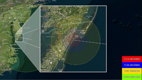
Ground cameras will be stationed at Wallops and in Duck, North Carolina, to view the vapor tracers. Clear skies are preferred, but not required, at both sites for the launch to occur.
The vapor tracers are formed through the interaction of barium, strontium and cupric-oxide. The tracers will be released at altitudes 96 to 124 miles high and pose absolutely no hazard to residents along the mid-Atlantic coast.
The vapor tracers could be visible from New York to North Carolina and westward to Charlottesville, Virginia. The total flight time for the mission is expected to be about 8 minutes.
The payload will land in the Atlantic Ocean about 90 miles from Wallops Island and will not be recovered.
They are shooting this "not" recovering rocket almost straight up???
From VA???
Can anyone remember something like this from NASA?
Get your cameras ready and tell your peeps too!
🍿
From VA???
Can anyone remember something like this from NASA?
Get your cameras ready and tell your peeps too!
🍿
a reply to: iWontGiveUP
Almost all their sounding rockets and even some satellite launches go from Wallops. They've launched from there multiple times in just the last few years. There were several threads about the launches.
en.m.wikipedia.org...
They mostly launch sounding rockets, and non space related missions there, but it's not uncommon for rockets to go from there.
Almost all their sounding rockets and even some satellite launches go from Wallops. They've launched from there multiple times in just the last few years. There were several threads about the launches.
In the early years, research at Wallops concentrated on obtaining aerodynamic data at transonic and low supersonic speeds. Between 1959 and 1961, Project Mercury[6] capsules were tested at Wallops in support of NASA's manned space flight program - the Mercury program - before astronauts were launched from Cape Canaveral Air Force Station in Florida. Some of these tests using the Little Joe booster rocket were designed to flight-qualify components of the spacecraft, including the escape and recovery systems and some of the life support systems. Two rhesus monkeys, Sam and Miss Sam, were sent aloft as pioneers for astronauts; both were recovered safely.
The first payload launched into orbit from Wallops Island was Explorer IX, atop a Scout rocket, on February 15, 1961.[7]
On September 6, 2013, the Lunar Atmosphere and Dust Environment Explorer (LADEE) was launched from Wallops, atop a Minotaur V rocket. This was the first time that an American lunar mission had been launched from anywhere but Florida.[8]
en.m.wikipedia.org...
They mostly launch sounding rockets, and non space related missions there, but it's not uncommon for rockets to go from there.
edit on
6/3/2017 by Zaphod58 because: (no reason given)
new topics
-
School shooting in Madison Wi.
Social Issues and Civil Unrest: 15 minutes ago -
Prisoner CNN helped free from Syrian prison was actually notorious Assad regime torturer: report
Mainstream News: 1 hours ago -
Labour Plotting to Postpone May's Council Elections ?
Regional Politics: 3 hours ago -
Is this really what is going on?
General Conspiracies: 3 hours ago -
Russias War Against Religion in Ukraine
World War Three: 4 hours ago -
iPhone Microphone Being Accessed by Unknown App
The Gray Area: 6 hours ago
top topics
-
iPhone Microphone Being Accessed by Unknown App
The Gray Area: 6 hours ago, 10 flags -
Is this really what is going on?
General Conspiracies: 3 hours ago, 8 flags -
Prisoner CNN helped free from Syrian prison was actually notorious Assad regime torturer: report
Mainstream News: 1 hours ago, 5 flags -
Democrats send letter to Biden urging him to ratify Equal Rights Amendment
US Political Madness: 12 hours ago, 4 flags -
Russias War Against Religion in Ukraine
World War Three: 4 hours ago, 4 flags -
Labour Plotting to Postpone May's Council Elections ?
Regional Politics: 3 hours ago, 2 flags -
School shooting in Madison Wi.
Social Issues and Civil Unrest: 15 minutes ago, 2 flags
active topics
-
Prisoner CNN helped free from Syrian prison was actually notorious Assad regime torturer: report
Mainstream News • 1 • : AgarthaSeed -
Is this really what is going on?
General Conspiracies • 25 • : Lazy88 -
School shooting in Madison Wi.
Social Issues and Civil Unrest • 0 • : DAVID64 -
Something better
Dissecting Disinformation • 32 • : fringeofthefringe -
Drones everywhere in New Jersey ---and Elsewhere Master Thread
Aliens and UFOs • 190 • : underpass61 -
Only two Navy destroyers currently operational as fleet size hits record low
Military Projects • 35 • : Oldcarpy2 -
Mass UAP events. DC. Machester Airport, UFOs over sub base in CT, Nuke bases.
Aliens and UFOs • 58 • : matafuchs -
The Acronym Game .. Pt.4
General Chit Chat • 1018 • : tinkerbell99 -
The Mystery Drones and Government Lies --- Master Thread
Political Conspiracies • 117 • : Guyfriday -
Russias War Against Religion in Ukraine
World War Three • 7 • : FlyersFan
