It looks like you're using an Ad Blocker.
Please white-list or disable AboveTopSecret.com in your ad-blocking tool.
Thank you.
Some features of ATS will be disabled while you continue to use an ad-blocker.
share:
Im going with the theory that a rogue wave was involved.
1) a underwater nuclear blast would have registered on seismographs
2) a meteor of the size needed to generate that large of a displacement wave would have left a visual pathway through the atmosphere, and given the region, there are alot of radar sets up and radiating that would have picked it up
1) a underwater nuclear blast would have registered on seismographs
2) a meteor of the size needed to generate that large of a displacement wave would have left a visual pathway through the atmosphere, and given the region, there are alot of radar sets up and radiating that would have picked it up
If it was a tsunami, caused by earthquake or an impact, there would have been an extreme low tide before the waves came ashore. Was there any report
of such a recession of the sea before this happened?
a reply to: TrueAmerican
There were at least 2 of those "small tsunamis". At least that's what the second video shows. Maybe a slow slip of tectonic plates, but those would have also been recorded by seismographs.
There were at least 2 of those "small tsunamis". At least that's what the second video shows. Maybe a slow slip of tectonic plates, but those would have also been recorded by seismographs.
originally posted by: TrueAmerican
But the bizarre thing is that no earthquake occurred to cause this. Because any earthquake large enough to cause this would have had to be over a 6.5, at the very least. And as we know, this would have registered on seismographs all over the region.
But there is nothing.
And so, what I believe happened is that most probably a small asteroid struck somewhere out in the Persian Gulf, and sent water flying. And I think they don't want to admit it, because of the embarrassment space agencies will face for not having detected it and not warned people. Not long ago we all remember what exploded over Russia. It was undetected as well.
I refuse to believe that much water, coming in at that speed, is caused from some storm 1,000 miles away. Just no. So man up, space agencies, and admit the truth. Another one slipped by you.
Could also be a number of things:
- The Bloop waking up
- Godzilla waking up
- Kaiju event
- Chuck Norris round-house kicking the ocean
- Al's mom falling off an oceanliner.
- Cthulhu waking up
- Cloverfield part III
- Weaponized tsunami (USA and NZ experimented with it during Cold War using either conventional explosives or nukes) However, setting it off would also trigger a small quake and the signature would be unmistakable and lots of people would be very very angry!
- Triple Kaiju event
- Coverfield part IV
- I'm tired typing!
originally posted by: muzzy
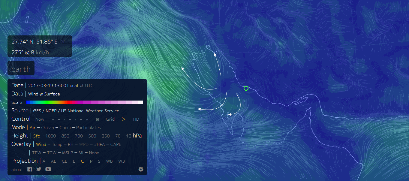
There WAS a storm to the west of Dayyer on the 19th. You can see it on the Nullschool Earth web site animations.
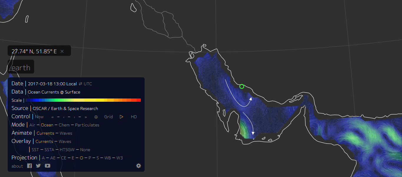
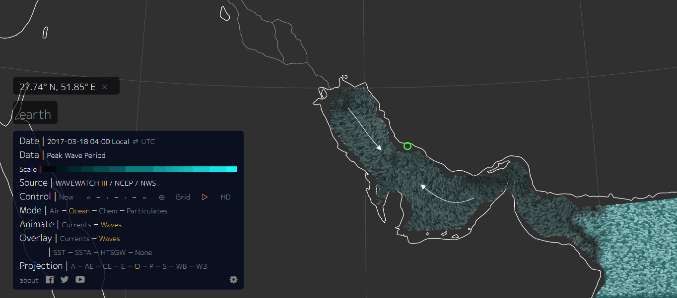
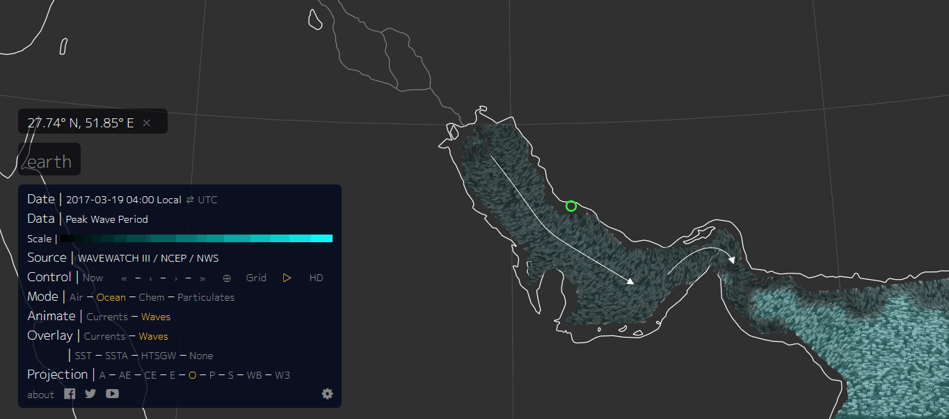
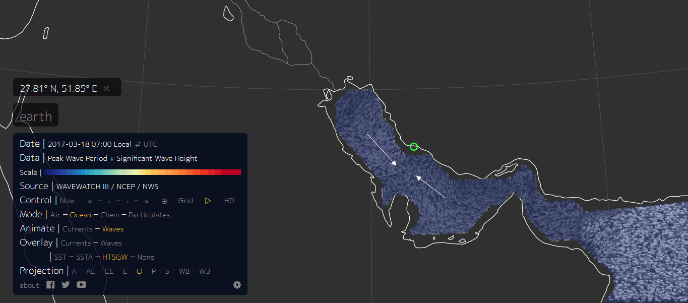
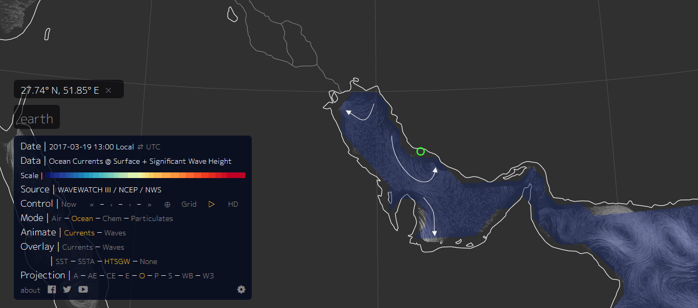
This is as close as I can zoom in, the white arrows show the direction of the overlays, wind, currents, waves. The green circle is the location of Dayyer. The relevant overlay type is highlighted by the orange text.
rightclickviewimages to see full size
Firstly the Wind. The eye of the Storm is pretty obvious, to the west of Dayyer (the green circle)
Then Currents.
Then Waves (18th March 2017 for comparison). Note the waves are coming from both directions towards a point offshore of Dayyer
Waves 19th March. By now the waves are just in one direction. This date/time stamp may be after the event had happened. The date stamp you will note is "local" time. The MSM never bother to indicate if the times are UTC or local, there is a 13 hour time difference!!!. Idiots. This is important, as you will see by the last 2 map images.
Peak Wave Period-Significant Wave Height.(18th March 07:00 local, !7th March 18:00)UTC
Again the waves are coming from both directions towards a point offshore of Dayyer
Peak Wave Period-Significant Wave Height. (19th March 13:00 local) We have waves swirling past Dayyer in towards the coast to the east.
One thing to remember is the Mirror story is quite sparce on actual facts, like the exact time, and the exact location. In middle eastern countries the name of a place can often relate to anywhere within 50km, was it Dayyer itself? or some seaside resort 50km east down the coast?
Its more obvious when animated, have a look yourself.
Hopefully the link will open on the date and area I was looking at. If not click on the word Earth to open the menu then follow your nose using the arrows to alter the dates and the words to bring up the overlays.
nu llschoolEarth
So it is quite likely it was a Storm.
Another clue is the 2nd video.
If it is in real time and hasn't been edited time wise, the 2nd wave came in pretty soon after the first one, similar to what you see at the beach on a normal day, sets of seven etc (Surfers would know what I mean) whereas Tsunamis seem to have quite a long period between surges, like 5-10 minutes or longer.
When someone details compelling evidence that backs up the official story and offers the simplest solution to the case in hand it pretty much solves things.
Interesting OP but this thread seems done to me.
Alternative sources are suggesting this Event in Iran was due to our planet's wobble that has become more erratic and extreme (*due to planet x's
gravitational effects).
There will also be tsunami caused by plate movements. Be well away from the coasts hundreds of meters in elevation. Do this asap!
Planet X will be passing this year surely based on all the data I have access to. I have tracked this object for two years, all pics in thread below. I have some extremely amazing pics I'll be adding at the weekend. Stay tuned and stay well!
www.abovetopsecret.com...
a reply to: EndOfDays77
So it's passing this year and causing tsunamis in Iran?
Must be visible to the whole world with the naked eye then, right?
So it's passing this year and causing tsunamis in Iran?
Must be visible to the whole world with the naked eye then, right?
originally posted by: mersaultdies
originally posted by: muzzy
There WAS a storm to the west of Dayyer on the 19th. You can see it on the Nullschool Earth web site animations.
This is as close as I can zoom in, the white arrows show the direction of the overlays, wind, currents, waves. The green circle is the location of Dayyer. The relevant overlay type is highlighted by the orange text.
rightclickviewimages to see full size
Firstly the Wind. The eye of the Storm is pretty obvious, to the west of Dayyer (the green circle)
Then Currents.
Then Waves (18th March 2017 for comparison). Note the waves are coming from both directions towards a point offshore of Dayyer
Waves 19th March. By now the waves are just in one direction. This date/time stamp may be after the event had happened. The date stamp you will note is "local" time. The MSM never bother to indicate if the times are UTC or local, there is a 13 hour time difference!!!. Idiots. This is important, as you will see by the last 2 map images.
Peak Wave Period-Significant Wave Height.(18th March 07:00 local, !7th March 18:00)UTC
Again the waves are coming from both directions towards a point offshore of Dayyer
Peak Wave Period-Significant Wave Height. (19th March 13:00 local) We have waves swirling past Dayyer in towards the coast to the east.
One thing to remember is the Mirror story is quite sparce on actual facts, like the exact time, and the exact location. In middle eastern countries the name of a place can often relate to anywhere within 50km, was it Dayyer itself? or some seaside resort 50km east down the coast?
Its more obvious when animated, have a look yourself.
Hopefully the link will open on the date and area I was looking at. If not click on the word Earth to open the menu then follow your nose using the arrows to alter the dates and the words to bring up the overlays.
nu llschoolEarth
So it is quite likely it was a Storm.
Another clue is the 2nd video.
If it is in real time and hasn't been edited time wise, the 2nd wave came in pretty soon after the first one, similar to what you see at the beach on a normal day, sets of seven etc (Surfers would know what I mean) whereas Tsunamis seem to have quite a long period between surges, like 5-10 minutes or longer.
When someone details compelling evidence that backs up the official story and offers the simplest solution to the case in hand it pretty much solves things.
Interesting OP but this thread seems done to me.
Well, while I think it was good research....I doubt 8km winds - 20km an hour winds would create such a wave, but I wouldn't be 100% confident it absolutely couldn't either as I am not from the area - not even close.
originally posted by: EndOfDays77
Planet X will be passing this year surely based on all the data I have access to.
Are you under some kind of NDA or something not to release that data? If not, why not share it?
A meteor impact WOULD cause a seismic event. It doesn't matter that there are no seismographs near the area, it would ring worldwide. Your rational
about it being a metal meteor and likening it to a .50 cal bullet being stopped by what a meter of water I think you said, is comical. That is not the
same thing. You left out a minor detail called mass.
Let me consult the magic 8 ball just to be sure, since we're just making crap up here. "Signs point to Storm Surge".
There you have it. The magic 8 ball speaks truth!
Let me consult the magic 8 ball just to be sure, since we're just making crap up here. "Signs point to Storm Surge".
There you have it. The magic 8 ball speaks truth!
a reply to: TrueAmerican
ds.iris.edu...
Could this be it? Earthquake recorded on Iranian/Turkmenistan border on 19th March.
Taken from: ds.iris.edu...
ds.iris.edu...
Could this be it? Earthquake recorded on Iranian/Turkmenistan border on 19th March.
Taken from: ds.iris.edu...
originally posted by: Chadwickus
a reply to: TrueAmerican
Surely even a meteorite impact would give off a seismic reading?
I am no expert or even amateur but why would a meteor hitting water cause a seismic event? Not claiming it wouldn't, I just don't understand how it works.
originally posted by: C84K2
a reply to: worldstarcountry
I read somewhere that tsunamis could be used as weapons of war. Intentionally created to cause maximum damage.
Reminds me of a line in the movie The Guardian about my former career in the Coast Guard, which was filmed in part at my former air station in North Carolina.
"I swim as fast as I can, for as long as I can, and the sea takes the rest."
Also, reminds of my talk about the reasons why the Chelyabinsk Meteor occurred.
originally posted by: EndOfDays77
Alternative sources are suggesting this Event in Iran was due to our planet's wobble that has become more erratic and extreme (*due to planet x's gravitational effects).
There will also be tsunami caused by plate movements. Be well away from the coasts hundreds of meters in elevation. Do this asap!
Planet X will be passing this year surely based on all the data I have access to. I have tracked this object for two years, all pics in thread below. I have some extremely amazing pics I'll be adding at the weekend. Stay tuned and stay well!
www.abovetopsecret.com...
Alternative sources are wrong.
There is no Planet X
All your pics are exactly what everyone in your thread has tried to tell you they are.
No Planet X will not be passing by this year because it's not real.
originally posted by: D8Tee
ht tp://www.presstv.ir/Detail/2017/03/19/514962/Iran-Dayyer-Assaluyeh-Nakhl-Taqi-Hamzeh-Etemad-Abdolrahim-Dadjou-Esmaeil-Najjar-Tsunami
originally posted by: LadyGreenEyes
a reply to: TrueAmerican
I can't find a single news story about this, anywhere; just the YT videos. Nothing remorely close to tsunami footage in those, and looks about like some hurricane surge to me.
The comments on that article are humorous. Many of them are blaming the USA for it, claiming we dont need to drop bombs. Others are blaming HARP.
This is very perplexing, to say the least. Dayyer is on the southwestern coastline of Iran, which borders the Persian Gulf. I do not understand how a
tsunami could have originated in the Persian Gulf and have no effects on Dubai or Bahrain, yet do this much damage to Iran. And if it didn't originate
in the Persian Gulf, but rather came in through the Gulf of Oman it certainly would have caused damage to Oman. This makes no sense. I have trouble
believing the date this video was recorded.
It wasn't a tsunami.
It isn't Planet X (X meaning 10, as we now know there are shedloads more than 10 bodies orbiting the sun).
The wave did not originate in the Persian Gulf and spread out like a pebble hitting water. The combination of depths, currents, wind direction and wind speed created the freak surge of the waters, probably not just at Dayyer but for miles either side. And not for the first time by the sound of it.
The speed of the wind alone aggravating a standard tidal system would not have caused the surge - it needed the other elements. The reason Bahrain, other lands west of the gulf and lands further north and south in Iran were not affected are shown in the evidence posted by another member. Look at the rotation of the winds and the bounceback of the waters from the north of the Gulf.
Finally, I haven't checked this but I would imagine if you investigated naval movements around the time they would have been minimal prior the storm occurring - which I suppose could also indicate that they knew a meteor was arriving. Plenty of military hardware in that area being as it is a cosy place to watch unfolding third world war in conception.
new topics
-
Resident Plane enthusiasts needed weird noise
General Chit Chat: 3 minutes ago -
Fired FEMA Employee Says It Was Not ‘Isolated’ Incident: ‘Colossal Event Of Avoidance’
US Political Madness: 2 hours ago -
Australia has been holding out on us
Music: 3 hours ago
top topics
-
Fired FEMA Employee Says It Was Not ‘Isolated’ Incident: ‘Colossal Event Of Avoidance’
US Political Madness: 2 hours ago, 18 flags -
DEI is getting pummled
Other Current Events: 13 hours ago, 16 flags -
Australia has been holding out on us
Music: 3 hours ago, 2 flags -
Resident Plane enthusiasts needed weird noise
General Chit Chat: 3 minutes ago, 0 flags
active topics
-
Thousands of Protesters March in NYC -- ‘Donald Trump Has Got To Go’
Social Issues and Civil Unrest • 102 • : 777Vader -
Resident Plane enthusiasts needed weird noise
General Chit Chat • 0 • : Hecate666 -
60s-70s Psychedelia
Music • 43 • : CyberianKhatru23 -
Fired FEMA Employee Says It Was Not ‘Isolated’ Incident: ‘Colossal Event Of Avoidance’
US Political Madness • 23 • : BernnieJGato -
DEI is getting pummled
Other Current Events • 12 • : YourFaceAgain -
Russia Ukraine Update Thread - part 3
World War Three • 6761 • : tomeville -
Encouraging News Media to be MAGA-PAF Should Be a Top Priority for Trump Admin 2025-2029.
Education and Media • 65 • : Kaiju666 -
The Acronym Game .. Pt.4
General Chit Chat • 936 • : Moon68 -
-@TH3WH17ERABB17- -Q- ---TIME TO SHOW THE WORLD--- -Part- --44--
Dissecting Disinformation • 3241 • : Lakotas -
Tomorrow will be the 7th day after the election, and they are still counting
US Political Madness • 34 • : Kaiju666

