It looks like you're using an Ad Blocker.
Please white-list or disable AboveTopSecret.com in your ad-blocking tool.
Thank you.
Some features of ATS will be disabled while you continue to use an ad-blocker.
Ancient Underwater Landslide Triggered 8-Story High Tsunami Near Australia's Great Barrier Reef
page: 116
share:
Normally when whe think of tsunamis, we think that they are related to earthquakes and most of the time this is correct. There are times, however, in
which an event occurs that is not an earthquake that also generates a tsunami; this is one such occurrence.
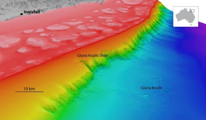
The size of the shelf which broke off and slid down was about 30 times the size of Ayers rock and was found when they were performing underwater mapping of the shelf off the coast near the Great Barrier Reef.
The reef itself would have mitigated much of the impact of the tsunami:
Source
Related articles:
Ancient undersea landslide discovered in Australia
Gloria Knolls Slide: A prominent submarine landslide complex on the Great Barrier Reef margin of north-eastern Australia
From the Science Direct article:
How does an underwater landslide cause a tsunami?
It's about water displacement. The larger the displacement, the larger the tsunami. Just take a look at what happened in Japan in 2011.
The Gloria Knolls Slide, an undersea landslide that occurred more than 300,000 years ago produced underwater hills and may have triggered powerful tsunami. The Great Barrier Reef may have dampened the impact of the waves. ( James Cook University )

The size of the shelf which broke off and slid down was about 30 times the size of Ayers rock and was found when they were performing underwater mapping of the shelf off the coast near the Great Barrier Reef.
The reef itself would have mitigated much of the impact of the tsunami:
Simulations of the event likewise showed that the ancient landslide was powerful enough to set off tsunami taller than an eight-story building.
The impact of the wave, however, was likely dampened by the Great Barrier Reef, if it existed at the time, which could have dispersed some of the surge's power.
"The Great Barrier Reef acts like a giant porous breakwater to reduce the energy [of ocean swell]," Beaman said. "If it was in existence at the time of this landslide, it would have done a similar job."
Source
Related articles:
Ancient undersea landslide discovered in Australia
Gloria Knolls Slide: A prominent submarine landslide complex on the Great Barrier Reef margin of north-eastern Australia
From the Science Direct article:

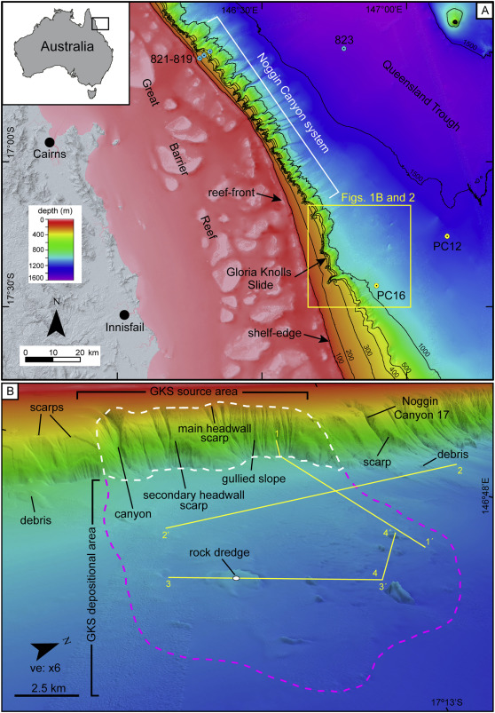
(A) Bathymetry (30-m resolution DEM) of the central part of the north-eastern Australia margin showing the location of the study area (yellow box inset) and main physiographic regions: Great Barrier Reef shelf and Queensland Trough. The slope is excavated by the Noggin Canyon system (Puga-Bernabéu et al., 2013b) and shows a large km-scale shelf indentation at the location of the Gloria Knolls Slide. Blue dots mark the position of the drilling sites of the Ocean Drilling Program Leg 133. Yellow dots mark the location of cores collected on RV Franklin Cruise FR4/92. Bathymetry contours in metres. (B) Westerly view showing the Gloria Knolls Slide (GKS) and adjacent seafloor features. The GKS is divided into a source area at the slope (white dashed line) and a depositional area in the trough (pink dashed line). Yellow lines mark the location of sub-bottom seismic profiles shown in Fig. 5. (For interpretation of the references to colour in this figure legend, the reader is referred to the web version of this article.)

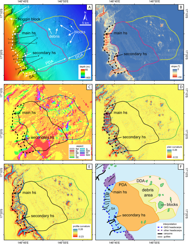
(A) Bathymetry (30-m resolution DEM) of the study area showing the three main seafloor terrains that can be distinguished in the Gloria Knolls Slide based on seafloor morphology: the source area (SA), the proximal depositional area (PDA) and distal depositional area (DDA). Headwall scarps (hs) are marked with dashed lines. White lines with letters and black lines with numbers correspond to depth profiles shown in Fig. 3. (B) Slope gradient map. (C) Maximum slope direction (aspect). (D) Plan curvature map. (E) Profile curvature map. (F) Interpreted seafloor features.

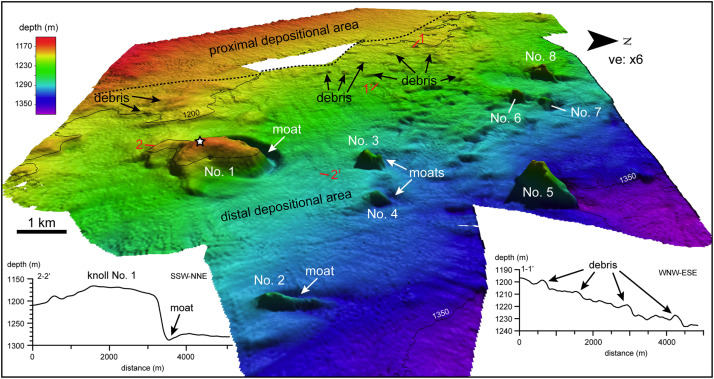
Westerly view of the distal depositional area of the Gloria Knolls Slide complex showing the distribution of larger knolls and smaller debris blocks on the seafloor. The knolls are numbered from 1 to 8. Red numbers mark the location of the two depth profiles shown across knoll No. 1 and the smaller debris field. Note the presence of moats at the northern sides of the knolls. White star marks the position of the collected rock dredge on top of knoll No. 1. (For interpretation of the references to colour in this figure legend, the reader is referred to the web version of this article.)
How does an underwater landslide cause a tsunami?
It's about water displacement. The larger the displacement, the larger the tsunami. Just take a look at what happened in Japan in 2011.
Besides asteroid impact these underwater slides create the largest tsunamis. Awesome work, thanks for the effort!
Fisherman ride out the Japan Tsunami at sea.
Fisherman ride out the Japan Tsunami at sea.
a reply to: jadedANDcynical
Much respect for the power of moving water. Thanks for the post.
I was just last month researching Lake Tahoe and found that a Mega Tsunami occurred due to an underwater paleo-landslide. Your last video made me think of it.
Much respect for the power of moving water. Thanks for the post.
I was just last month researching Lake Tahoe and found that a Mega Tsunami occurred due to an underwater paleo-landslide. Your last video made me think of it.
The thing that makes this phenomena interesting is that it is not relegated to only earthquake prone areas:
And this is not even referencing Cumbre Vieja. That, at least, is still (theoretically) volcanic in origin.

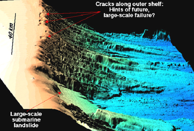
These incidences are just land slipping due to a variety of factors that don't necessarily have anything to do with tectonic or volcanic activity.
Heck, I live in the Texas Gulf Coast and could potentially have to contend with one of these. Now, they are a good deal more rare (let's hope so anyway) than those generated by tectonic activity so there is that bright spot, but the very fact that they could occur in places most people would not even think of it as a possibility is troublesome.
Unlike tsunamis generated by earthquake, underwater slides generated by tsunami can happen around the Atlantic as well as the Pacific rim.
And this is not even referencing Cumbre Vieja. That, at least, is still (theoretically) volcanic in origin.

Side scan sonar images of the Goleta slide along the edge of the continental shelf on the western edge of North America offshore southern California near Goleta, Santa Barbara County.

Side scan sonar images of the Albemarle-Currituck slide along the edge of the continental shelf on the eastern edge of North America offshore offshore North Carolina.
These incidences are just land slipping due to a variety of factors that don't necessarily have anything to do with tectonic or volcanic activity.
Heck, I live in the Texas Gulf Coast and could potentially have to contend with one of these. Now, they are a good deal more rare (let's hope so anyway) than those generated by tectonic activity so there is that bright spot, but the very fact that they could occur in places most people would not even think of it as a possibility is troublesome.
a reply to: jadedANDcynical
Thank you for posting this. I enjoying reading about this kind of thing.
The Cumbre Vieja topic is one of the reasons I joined ATS.
Yea, That video made me alittle dizzy too.
Thank you for posting this. I enjoying reading about this kind of thing.
The Cumbre Vieja topic is one of the reasons I joined ATS.
Yea, That video made me alittle dizzy too.
new topics
-
Advice for any young Adult .
General Chit Chat: 8 minutes ago -
Joe meant what he said about Hunter's pardon....
US Political Madness: 56 minutes ago -
Regent Street in #London has been evacuated due to a “bomb threat.”
Other Current Events: 1 hours ago -
It’s Falling…
Philosophy and Metaphysics: 3 hours ago -
Steering the Titantic from the Drydock.
Rant: 6 hours ago
top topics
-
House Passes Laken Riley Act
Mainstream News: 17 hours ago, 24 flags -
Steering the Titantic from the Drydock.
Rant: 6 hours ago, 10 flags -
Hearing more ambulances lately
Medical Issues & Conspiracies: 17 hours ago, 8 flags -
Paramilitary Leaks - John Williams
Whistle Blowers and Leaked Documents: 15 hours ago, 7 flags -
Los Angeles brush fires latest: 2 blazes threaten structures, prompt evacuations
Mainstream News: 17 hours ago, 7 flags -
Joe meant what he said about Hunter's pardon....
US Political Madness: 56 minutes ago, 6 flags -
It’s Falling…
Philosophy and Metaphysics: 3 hours ago, 4 flags -
Some sausage, some chicken, some sauce, some onions and some garlic...and some peppers!
Food and Cooking: 16 hours ago, 3 flags -
Regent Street in #London has been evacuated due to a “bomb threat.”
Other Current Events: 1 hours ago, 2 flags -
Advice for any young Adult .
General Chit Chat: 8 minutes ago, 2 flags
16
