It looks like you're using an Ad Blocker.
Please white-list or disable AboveTopSecret.com in your ad-blocking tool.
Thank you.
Some features of ATS will be disabled while you continue to use an ad-blocker.
4
share:
I found this glitch looking for various entry points from shoreline across the Antarctic plains to plan an expedition. When I kept seeing the same
glitch popping up again and again, I zoomed in to get a better look at it.
This is what I found:
The mouse kept jumping around, trying to navigate this weird line that appears as a part of the pixilation of the area that’s supposedly just too darn difficult to image by our satellite technology to show us what’s actually there.
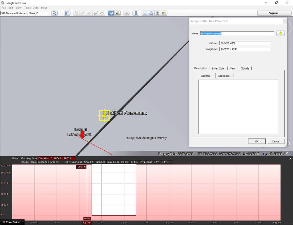
This is a picture of one of the the areas I’m talking about showing the elevation profile that illustrates how deep it is (from the top of the plain to sea level.)

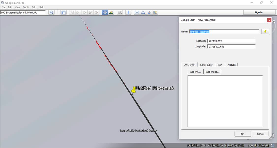
This is a picture of a small section of the circle, revealing the black area that I kept seeing (the glitched out black area is the “chasm” part) You have to roll the screen around in the 3d mode at any spot on the circle and eventually you’ll catch a little black line that squirms around when you get at the correct angle to see it. Otherwise, you can just start by placing a single path across the black area, and you should see the mouse jump around on you as it attempts to navigate across the chasm.

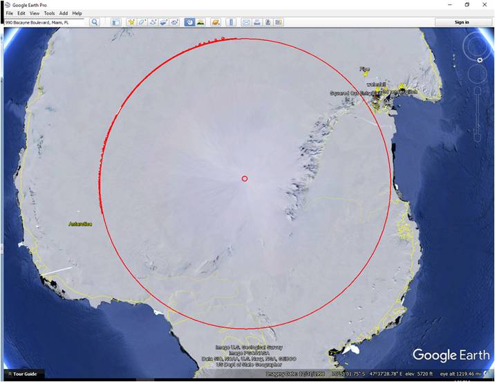
This is the zoomed out version where I traced most of the circle’s radius at the top portion. I started out following the “chasm” glitch precisely, then just got tired of doing this and so I stretched a circle to overlay, and it coincidentally has a radius of 777 miles. Weird!

I’d think the 777 thing is a coincidence, but I know the conspiracy folks like that number so I thought I’d highlight it. If you have problems finding it, let me know and I’ll help with the navigation on the google earth. It’s a little wonky which is another reason I assume its just glitchy, you have to angle the thing just right to see the black part of the “chasm”.
-Alex
This is what I found:
The mouse kept jumping around, trying to navigate this weird line that appears as a part of the pixilation of the area that’s supposedly just too darn difficult to image by our satellite technology to show us what’s actually there.
This is a picture of one of the the areas I’m talking about showing the elevation profile that illustrates how deep it is (from the top of the plain to sea level.)

This is a picture of a small section of the circle, revealing the black area that I kept seeing (the glitched out black area is the “chasm” part) You have to roll the screen around in the 3d mode at any spot on the circle and eventually you’ll catch a little black line that squirms around when you get at the correct angle to see it. Otherwise, you can just start by placing a single path across the black area, and you should see the mouse jump around on you as it attempts to navigate across the chasm.

This is the zoomed out version where I traced most of the circle’s radius at the top portion. I started out following the “chasm” glitch precisely, then just got tired of doing this and so I stretched a circle to overlay, and it coincidentally has a radius of 777 miles. Weird!

I’d think the 777 thing is a coincidence, but I know the conspiracy folks like that number so I thought I’d highlight it. If you have problems finding it, let me know and I’ll help with the navigation on the google earth. It’s a little wonky which is another reason I assume its just glitchy, you have to angle the thing just right to see the black part of the “chasm”.
-Alex
nm
edit on 5-10-2016 by EmmanuelGoldstein because: (no reason given)
a reply to: androal
I doubt the number 777 has much significance but i do think google earth sensors quite a few things on behalf of TPTB. Antarctica being one of them.
People demand proof when I say that there's significant activity going on in Antarctica right now. Human activity and perhaps inner earth activity. I don't have the proof. But ive heard from reputable sources that there's been a major influx of shadowy elites to the area because of its underground bases.
Theyre doing this to escape upcoming nuclear war AND they also believe there's a solar event coming of cataclysmic proportions.
Or perhaps they know there's a consciousness shift that's growing by the day, and they don't want to be subject to arrests.
Just some food for thought. Take it as you will.
Second thread ive seen about this today. now im interested in seeing whats going on there.
Been to the Arctic numorous times - i worked for a few different exploration companies.
So im familiar with the north pole.
Havent been lucky enough to get to goto the south yet.
Edit: nm your the one who posted it earlier in the intro forums.
Been to the Arctic numorous times - i worked for a few different exploration companies.
So im familiar with the north pole.
Havent been lucky enough to get to goto the south yet.
Edit: nm your the one who posted it earlier in the intro forums.
edit on 5-10-2016 by Macenroe82 because: (no reason given)
a reply to: Macenroe82
Yeah... sorry about that. Still learning how to use this forum. I'm new to it all and as one of the previous users pointed out to me, you have to sorta learn as you go.
I combined these and added new info to the post and then reposted it to the appropriate forum. I didn't even realize I posted this to the General Chit Chat forum!
Apologies.
edit on 5-10-2016 by androal because: (no reason given)
Great thanks, now I have to go back to the GD inner earth theories and nazi submarines.
Just playing, I love the stories, bring it.
I did remember something about the satellites having trouble hitting the right angles at that location causing a software stitch on the image.
If you use the search button here on ATS, you can probably find some good discussions on the location.
Welcome to the chaos, by the way
a reply to: androal
No need to apologise to me my friend. Im not one of the members that gets all twisted up if someone does something wrong while learning the site.
If you have any questions in regards how to do something on ATS, please feel free to send me a PM.
Ill help you out anyway I can!
No need to apologise to me my friend. Im not one of the members that gets all twisted up if someone does something wrong while learning the site.
If you have any questions in regards how to do something on ATS, please feel free to send me a PM.
Ill help you out anyway I can!
new topics
-
Why Such An Uproar Over Non-US Citizens With H1-B Work Visas.
Social Issues and Civil Unrest: 1 hours ago -
Christmas Car Near Detroit…
Automotive Discussion: 3 hours ago -
Assetto Corsa EVO - a New Chapter in Simracing starts January 16th
Video Games: 6 hours ago -
The Phenomenon documentary by James Fox
Aliens and UFOs: 9 hours ago -
New UK Petition - Close the borders! Suspend ALL immigration for 5 years!
Regional Politics: 10 hours ago
top topics
-
Credit card debt
Relationships: 14 hours ago, 7 flags -
The Phenomenon documentary by James Fox
Aliens and UFOs: 9 hours ago, 7 flags -
President-elect Trump asks the Supreme Court to Let Tik-Tok Continue Operating in the U.S..
Mainstream News: 15 hours ago, 6 flags -
Christmas Car Near Detroit…
Automotive Discussion: 3 hours ago, 5 flags -
Why Such An Uproar Over Non-US Citizens With H1-B Work Visas.
Social Issues and Civil Unrest: 1 hours ago, 5 flags -
The Looking Glass - Episode 3: The Path of Least Resistance
Short Stories: 12 hours ago, 3 flags -
New UK Petition - Close the borders! Suspend ALL immigration for 5 years!
Regional Politics: 10 hours ago, 2 flags -
Assetto Corsa EVO - a New Chapter in Simracing starts January 16th
Video Games: 6 hours ago, 2 flags
active topics
-
Why Such An Uproar Over Non-US Citizens With H1-B Work Visas.
Social Issues and Civil Unrest • 10 • : BeyondKnowledge3 -
Liberal Madness and the Constitution of the United States
US Political Madness • 19 • : charlest2 -
Plane Crash Today --Azerbaijanian E190 passenger jet
Mainstream News • 63 • : GENERAL EYES -
Christmas Car Near Detroit…
Automotive Discussion • 3 • : BeyondKnowledge3 -
Treasury Secretary Janet Yellen Says The USA Will Be in Debt Default in Jan 2025 - Unless...
Mainstream News • 32 • : cherokeetroy -
1 Billion dollars
General Entertainment • 15 • : mblahnikluver -
President-elect Trump asks the Supreme Court to Let Tik-Tok Continue Operating in the U.S..
Mainstream News • 24 • : WeMustCare -
Awesome Dip Recipe
Food and Cooking • 7 • : mblahnikluver -
Christmas Dinner ??
Food and Cooking • 19 • : mblahnikluver -
Trump's idea to make Canada the 51st US state: 'Potential is massive'
Mainstream News • 103 • : NorthOS
4
