It looks like you're using an Ad Blocker.
Please white-list or disable AboveTopSecret.com in your ad-blocking tool.
Thank you.
Some features of ATS will be disabled while you continue to use an ad-blocker.
33
share:
I've wanted to share with you some of my favorite lesser known ancient sites from around the world for some time. They're each unique in their own
way. Some of these sites have been mentioned here before, I'm also sure that some here are already aware of them. I chose these sites due to their age
and the locations. Oftentimes many better known sites of their respective regions over shadow these.
Let's begin with the Phoenicians, one of my favorite ancient people, who at a time brought so much richness to their world through trade and many other contributions we still to this day are benefactor of.
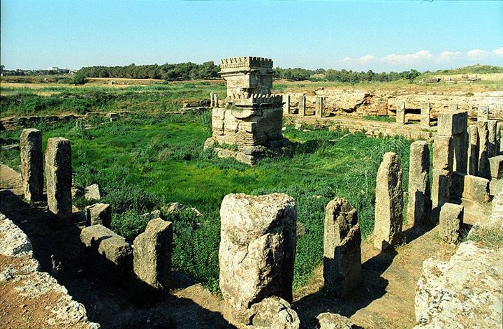 Amrit
Amrit
This next site is from Mexico.
What makes this site interesting is that comes to us from a period very early on from a people supposedly not much more than hunter gatherers. Also, there is some controversy over it's age. Not only is it's age and location of interest but of it's design which is circular rather than the typical four sided pyramids and or simply mounds. A crossover period? In any case, whether it's controversial age or style of construction I thought it worthy to post and mention.
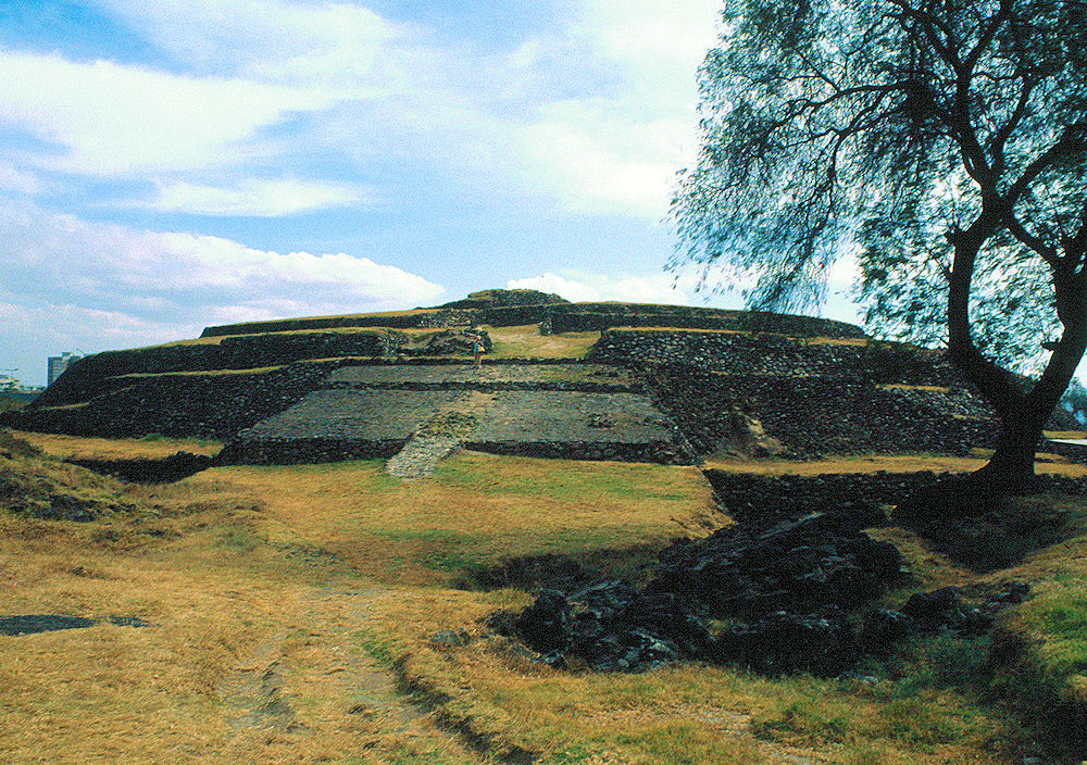 Cuicuilco
Next, let's take a quick virtual hop down to Peru and visit a couple of interesting sites. The first area has a solar observatory and a rather interesting "fortress" Both are worth taking the time to read up on if you're like me and enjoy learning new things about now forgotten ancient cultures and people.
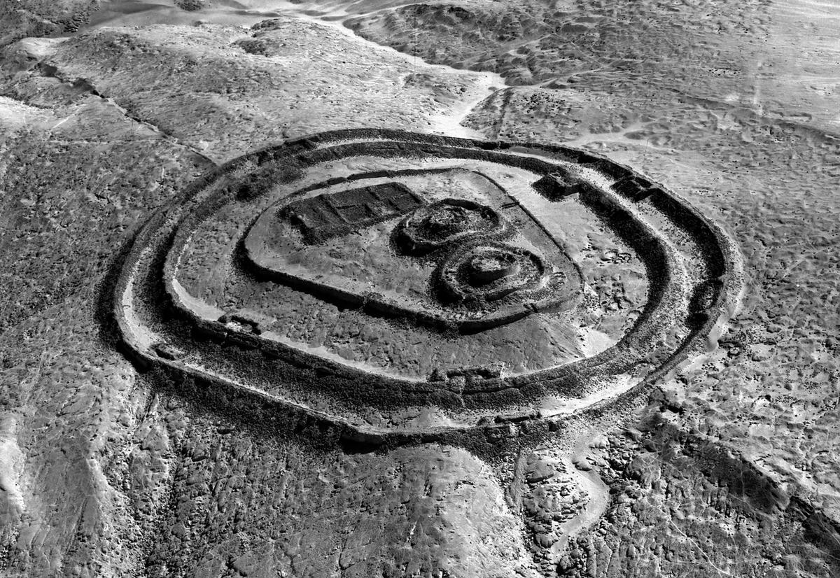 Peru's ancient solar
observatory
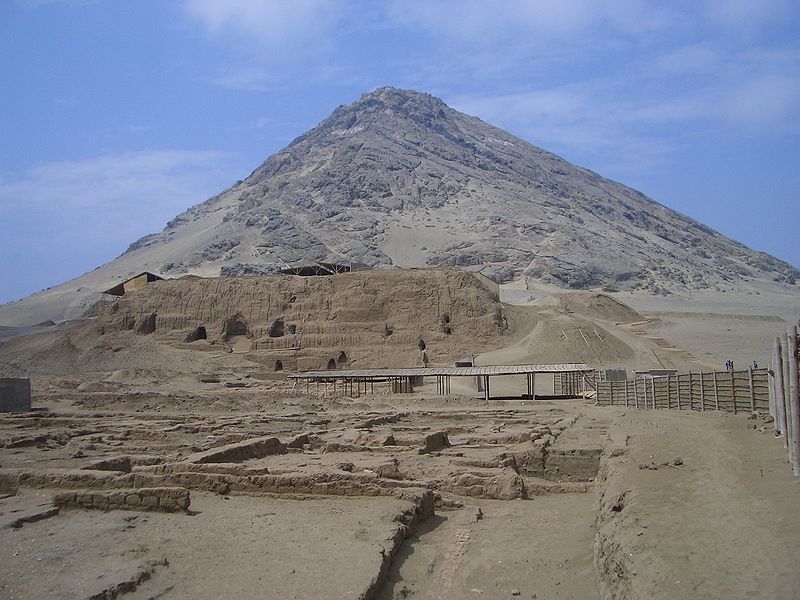 Huaca de la
Luna
As Always,
Stay tuned.
Let's begin with the Phoenicians, one of my favorite ancient people, who at a time brought so much richness to their world through trade and many other contributions we still to this day are benefactor of.
Amrit

Amrit or Amrith (Arabic: عمريت), also known as Marathos or Marathus (Ancient Greek: Μάραθος), was an ancient Phoenician city located near Tartus in Syria. Founded in the third millennium BC and abandoned during the second century BC, the city's Phoenician ruins have been preserved in their entirety without extensive remodeling by later generations.
One of the most important excavations at Amrit was the Phoenician temple, commonly referred to the "ma'abed," dedicated to the god Melqart of Tyre and Eshmun. The colonnaded temple, excavated between 1955 and 1957, consists of a large court cut out of rock measuring 47 × 49 metres (154 × 161 ft) and over 3 metres (9.8 ft) deep, surrounded by a covered portico. In the center of the court a well-preserved cube-shaped cella stands. The open-air courtyard was filled with the waters of a local, traditionally sacred spring, a unique feature of this site. The temple—which was dated to the late 4th century BC, a period following the Persian expansion into Syria—shows major Achaemenid influence in its layout and decoration. According to Dutch archaeologist, Peter Akkermans, the temple is the "best-preserved monumental structure from the Phoenician homeland."
A second temple, described by visitors to the site in 1743 and 1860 and thought to have disappeared, was later discovered by the Syrian archaeological mission near the Nahr al-Kuble spring.
This next site is from Mexico.
What makes this site interesting is that comes to us from a period very early on from a people supposedly not much more than hunter gatherers. Also, there is some controversy over it's age. Not only is it's age and location of interest but of it's design which is circular rather than the typical four sided pyramids and or simply mounds. A crossover period? In any case, whether it's controversial age or style of construction I thought it worthy to post and mention.
Cuicuilco

In a suburb of Mexico City sits a circular pyramid, partially covered by a lava field from the Xitle volcano. The pyramid of Cuicuilco rises to no more than 18 metres in height, though measures 120 metres in diameter. Excavated for the first time by Mexican archaeologist Manuel Gamio in 1917, the original height is estimated to have been 27 metres. Gamio discovered four galleries and a central staircase that went to the summit. The site was been dated to the 1st century AD, and is believed to have been the oldest pyramid structure in the New World – predating Teotihuacan, north of Mexico City. Cuicuilco may also have been the oldest city in the Valley of Mexico and was roughly contemporary with, and possibly interacting with, the Olmec civilisation of the Gulf Coast. This already makes it highly important.
Still, it is not a true pyramid, being rather a truncated conical mound, with a clay-and-rubble core faced with river boulders and basalt slabs. But despite not adhering to the “true” pyramid shape, it nevertheless is as controversial – if not more so – than several other true pyramids...
Though recognised as “the oldest”, a central question was “how old”? National Geographic discussed Cuicuilco in 1923 (no. 44). In the 1922, Byron Cummings of the University of Arizona became interested in the structure when he learned that a geologist named George E. Hyde had estimated the age of the flow, the Pedregal lava flow, as being 7000 years old. This resulted in an obvious contradiction: how could a pyramid be 5000 years younger than the lava covering it?
Next, let's take a quick virtual hop down to Peru and visit a couple of interesting sites. The first area has a solar observatory and a rather interesting "fortress" Both are worth taking the time to read up on if you're like me and enjoy learning new things about now forgotten ancient cultures and people.
The fortified temple at Chankillo

A line of 2,300-year-old stone towers north of Lima, Peru, form the oldest known solar observatory in the Americas, a team of archaeologists has found. The discovery that the line of stone markers tracks the sun's progress across the sky also suggests that sophisticated sun worship may have thrived in the region nearly two millennia prior to the famous sun cults of the Incas, the team says.
Known as the Thirteen Towers of Chankillo, the structures sit atop a low ridge in north coastal Peru, part of a ceremonial complex dating to the 4th century B.C. Ranging from 2 to 6 meters high, the towers form a toothed horizon along the ridge. The 4-square-kilometer site also contains multiple structures and plazas, including two structures that precisely flank the towers to the east and west. Earlier excavations uncovered pottery, shells and stone fragments littering the site around one of the structures.
Huaca de la Luna

The Huacas de Moche site is located 4 km outside the modern city of Trujillo, near the mouth of the Moche River valley. The Huaca de la Luna, though it is the smaller of the two huacas at the site, has yielded the most archaeological information. The Huaca del Sol was partially destroyed and looted by Spanish conquistadors in the 17th century, while the Huaca de la Luna was left relatively untouched. Archeologists believe that the Huaca del Sol may have served for administrative, military, and residential functions, as well as a burial mound for the Moche elite. The Huaca de la Luna served primarily a ceremonial and religious function, though it contains burials as well.
Today the Huaca de la Luna is colored the soft brown of its adobe brickwork. At the time of construction, it was decorated in registers of murals which were painted in black, bright red, sky blue, white, and yellow. The sun and weather has since utterly faded these murals away. Inside the Huaca are other murals created in earlier phases of construction. Many of these depict a deity now known as Ayapec. Ayapec is a pre-Quechua word translating as all knowing. "Wrinkle-Face" is the name given to another deity by the later Inca because of the deity's appearance.
As Always,
Stay tuned.
edit on 22-3-2016 by SLAYER69 because: (no reason given)
Thanks! Have some reading to do on some things that are new to me. It is amazing how much there is still left to discover!
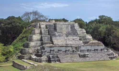
Altun Ha Belize
Altun-Ha means "stone water" - is located approximately 30 miles north of Belize City. This ceremonial center, located six miles from the sea, was important as a trading center and as a link between the coast and the settlements of the interior. Within the central portion of the site there are more than 500 structures. The entire city covered some 1.8 square miles and contains around 250 to 300 mounds that have never been excavated. Population estimates for Altun Ha at its peak are 9,000 to 12,000. Also, a treasure of over 300 jade objects was found there, including the ornately carved head of Kinisch Ahau, the Mayan Sun God. This head, weighing 9 3/4 pounds and measuring nearly 6 inches from the base of the crown, is believed to be the largest Maya jade carving in existence. Caracol means "conch shell" or "snail", is located south of San Ignacio, in the Cayo district. Though only considered to be a simple Mayan ceremonial center when discovered in 1938, it was later found to be one of the largest sites in all the Maya World. The center of the site has about 20 major plazas and the pyramid, the Canaa, meaning "sky palace", which rises 140 ft and is the tallest man-made structure in Belize.
www.crystalinks.com...
Belize get little love in comparison to it's neighbor to the north Mexico and to a lesser extent it's neighbor to the south Guatemala, but it does have it's temples and pyramids.
I love threads like this.
When I see some of these sites...it always looks like perches.
S&F
When I see some of these sites...it always looks like perches.
S&F
a reply to: Spider879
Well I didn't know it was a party!
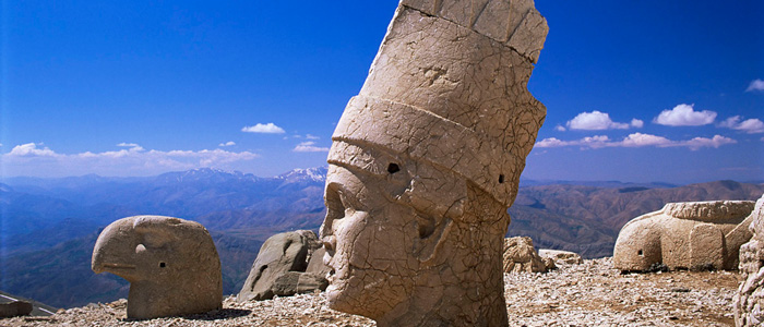
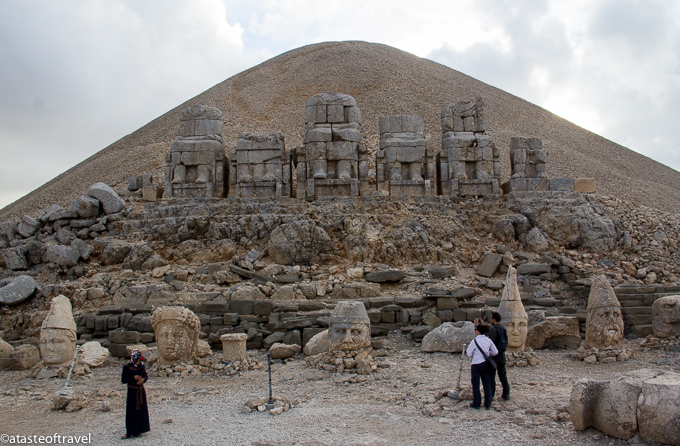
Mount Nemrut
Well I didn't know it was a party!


Mount Nemrut
The mountain lies 40 km (25 mi) north of Kahta, near Adıyaman. In 62 BC, King Antiochus I Theos of Commagene built on the mountain top a tomb-sanctuary flanked by huge statues 8–9 m (26–30 ft) high of himself, two lions, two eagles and various Greek, Armenian, and Iranian gods, such as Vahagn-Hercules, Aramazd-Zeus or Oromasdes (associated with the Iranian god Ahura Mazda), Bakht-Tyche, and Mihr-Apollo-Mithras. These statues were once seated, with names of each god inscribed on them. The heads of the statues have at some stage been removed from their bodies, and they are now scattered throughout the site.
The pattern of damage to the heads (notably to noses) suggests that they were deliberately damaged as a result of iconoclasm. The statues have not been restored to their original positions. The site also preserves stone slabs with bas-relief figures that are thought to have formed a large frieze. These slabs display the ancestors of Antiochus, who included Armenian, Greek and Persians.
The same statues and ancestors found throughout the site can also be found on the tumulus at the site, which is 49 m (161 ft) tall and 152 m (499 ft) in diameter. It is possible that the tumulus was build to protect a tomb from tomb-robbers since any excavation would quickly fill with loose rock.[1] The statues appear to have Greek-style facial features, but Armenian clothing and hair-styling.
edit on 2016-3-22 by theantediluvian
because: (no reason given)
a reply to: SLAYER69
Fantastic read thank you very much.
Each is fascinating but the one that immediately got my attention is the Cuicuilco because it immediately reminded me of a larger version of New Grange.
Ancient circular monuments fascinate me and I remember reading about one of the oldest synagogs that was circular also with its age depicted planetarily on its ceiling. I love the idea of circular buildings although obviously the later pyramids are very impressive indeed.
The Fortified Temple at Chankillo was also reminiscent of some of the hill forts and ancient sites elsewhere which again says to me that originally we travelled far more than scholars want to accept. Our liking what we saw elsewhere meant we wanted to build similar structures in our home lands. Copying is a form of respect which many of these buildings certainly command not only with their brilliant design but also their beauty and location.
Will certainly stay tuned.
originally posted by: Byrd
We should mount an expedition!
No thanks, I have a feeling me and you would argue all the time Perhaps in another life... Oh that's right, you don't believe in that ...
-MM
edit on 23-3-2016 by MerkabaMeditation because: (no reason given)
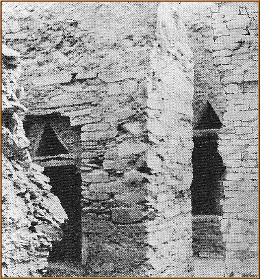
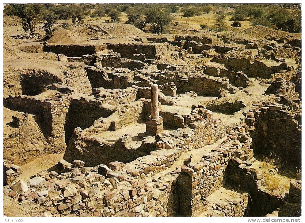
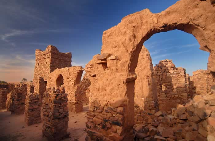
Posted on this before, this is the site of the Wagadu empire aka Ghana, according Augustin Holl the site was concurrent with pre-dynastic Kmt at 4000yrs B.C and came of age in 2600yrs B.C they experienced some decline at about 1500yrs B.C but had a resurgence that lasted until about 1200 A.D when they were done in by the encroaching desert and the expansionist Mali empire, their ethnic group were the Soninke and are somewhat related to the Mandingo.
Thank you for this one Slayer! I have truly come to look forward to your posts. Might I suggest Pella, Jordan. I am new so I am still learning to put
pictures up. But Pella has been occupied since neolithic times. They have even unearthed a Canaanite Temple from around 1700 BC. Worth a look at
least.
new topics
-
Simulation theory and have we reset before like a game?
Conspiracies in Religions: 4 hours ago -
Imagine how it feels
US Political Madness: 6 hours ago -
Do I post here or Cryptozoology.
Ancient & Lost Civilizations: 7 hours ago -
Breakthrough treatment flips cancer cells back into normal cells
General Chit Chat: 7 hours ago -
New World Order Coming?
New World Order: 8 hours ago
top topics
-
Breakthrough treatment flips cancer cells back into normal cells
General Chit Chat: 7 hours ago, 9 flags -
Imagine how it feels
US Political Madness: 6 hours ago, 8 flags -
Short vs. Long?
General Chit Chat: 16 hours ago, 5 flags -
New World Order Coming?
New World Order: 8 hours ago, 5 flags -
Do I post here or Cryptozoology.
Ancient & Lost Civilizations: 7 hours ago, 5 flags -
Simulation theory and have we reset before like a game?
Conspiracies in Religions: 4 hours ago, 4 flags
active topics
-
Kurakhove officially falls. Russia takes control of major logistics hub city in the southeast.
World War Three • 35 • : nugget1 -
Outgoing Lame Duck BIDEN Officials and Democrats Voice Their Regrets.
2024 Elections • 23 • : nugget1 -
Reflections of Elections past
US Political Madness • 5 • : lilzazz -
Simulation theory and have we reset before like a game?
Conspiracies in Religions • 7 • : ARM19688 -
Why Such An Uproar Over Non-US Citizens With H1-B Work Visas.
Social Issues and Civil Unrest • 122 • : Daughter2v2 -
New World Order Coming?
New World Order • 21 • : BeyondKnowledge3 -
Mood Music Part VI
Music • 3771 • : lilzazz -
Treasury Secretary Janet Yellen Says The USA Will Be in Debt Default in Jan 2025 - Unless...
Mainstream News • 41 • : Astrocometus -
Post A Funny (T&C Friendly) Pic Part IV: The LOL awakens!
General Chit Chat • 7971 • : Cymru -
President Carter has passed
Mainstream News • 24 • : Skinnerbot
33
