It looks like you're using an Ad Blocker.
Please white-list or disable AboveTopSecret.com in your ad-blocking tool.
Thank you.
Some features of ATS will be disabled while you continue to use an ad-blocker.
share:
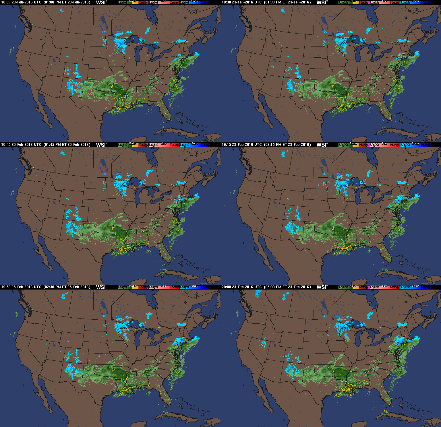
Another severe weather alert, ATS.
At this time, tornado warnings are already in effect in the Gulf Coast.
Several tornadoes and moderate damage has also been reported.
_________
The threat of dangerous severe storms capable of producing tornadoes will continue to increase through Tuesday afternoon and evening in the Gulf Coast states.
_________
Feb. 23, 2016 - Day 1 Convective Outlook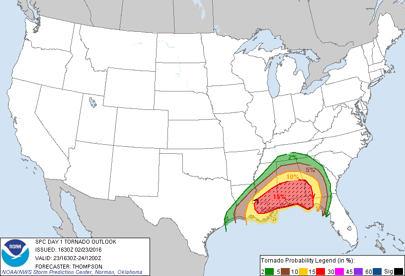
^More information at the link.
_________
Public Severe Weather Outlook (PWO)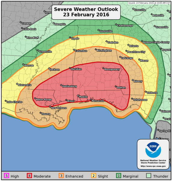
_________
This is a developing situation,
so stay alert if you are in the watch area.
Be sure to monitor your local weather,
and stay up to date on any warnings, etc.
LIVE STORM CHASING (TVN) LINK
More to come...
Be safe
At this time, tornado warnings are already in effect in the Gulf Coast.
Several tornadoes and moderate damage has also been reported.
_________
The threat of dangerous severe storms capable of producing tornadoes will continue to increase through Tuesday afternoon and evening in the Gulf Coast states.
_________
Feb. 23, 2016 - Day 1 Convective Outlook

www.spc.noaa.gov...
...SUMMARY...
SEVERE THUNDERSTORMS CAPABLE OF PRODUCING TORNADOES, DAMAGING WINDS... AND ISOLATED LARGE HAIL WILL BE LIKELY OVER PORTIONS OF THE GULF COAST STATES THROUGH TONIGHT.
A FEW STRONG TORNADOES WILL BE POSSIBLE.
^More information at the link.
_________
Public Severe Weather Outlook (PWO)

www.spc.noaa.gov...
PUBLIC SEVERE WEATHER OUTLOOK
NWS STORM PREDICTION CENTER NORMAN OK
1049 AM CST TUE FEB 23 2016
...Severe thunderstorms expected over parts of the southeast US this
afternoon and tonight...
* LOCATIONS...
Central and Southern Alabama
Southern Mississippi
Florida Panhandle
Southeast Louisiana
Southwest through Central Georgia
* HAZARDS...
Several tornadoes, a few intense
Scattered damaging winds
Isolated large hail
* SUMMARY...
Severe thunderstorms capable of producing tornadoes, damaging
winds, and isolated large hail will be likely over portions of
the Gulf Coast states through tonight. A few strong tornadoes
will be possible.
_________
This is a developing situation,
so stay alert if you are in the watch area.
Be sure to monitor your local weather,
and stay up to date on any warnings, etc.
LIVE STORM CHASING (TVN) LINK
More to come...
Be safe
edit on 23-2-2016 by iunlimited491 because: (no reason given)
Storms woke me up in the early morning but it wasn't severe. After our Christmas wedge F4 tornado I am very relieved not to be included in this
watch!
Stay on your toes, guys. Don't brush off these watches and warnings. What happened to us can happen to you, too!
Stay on your toes, guys. Don't brush off these watches and warnings. What happened to us can happen to you, too!
MESOSCALE DISCUSSION 126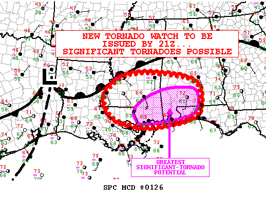

www.spc.noaa.gov...
AREAS AFFECTED...PORTIONS OF CNTRL/SRN MS...SERN LA...SWRN/S-CNTRL
AL...WRN FL PANHANDLE
CONCERNING...SEVERE POTENTIAL...TORNADO WATCH LIKELY
VALID 231915Z - 232115Z
PROBABILITY OF WATCH ISSUANCE...95 PERCENT
...SUMMARY...
THE RISK FOR TORNADOES WILL BE FURTHER INCREASING DURING THE NEXT COUPLE OF HOURS
ACROSS PARTS OF SERN LA INTO CNTRL/SRN MS... WITH THE TORNADO RISK SPREADING INTO SWRN/S-CNTRL AL AND THE WRN FL PANHANDLE BY THIS EVENING.
SIGNIFICANT TORNADOES WILL BE POSSIBLE.
A NEW TORNADO WATCH WILL LIKELY BE ISSUED BY AROUND 21Z.
Good luck to everyone in the area, that's a pretty ill prepared area for Tornadoes.
PARTICULARLY DANGEROUS SITUATION (PDS) - Tornado Watch 20
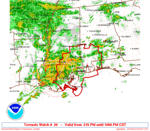

www.spc.noaa.gov...
URGENT - IMMEDIATE BROADCAST REQUESTED
...THIS IS A PARTICULARLY DANGEROUS SITUATION...
* PRIMARY THREATS INCLUDE...
SEVERAL TORNADOES AND A FEW INTENSE TORNADOES LIKELY
SCATTERED DAMAGING WIND GUSTS TO 70 MPH LIKELY
ISOLATED LARGE HAIL EVENTS TO 1 INCH IN DIAMETER POSSIBLE
SUMMARY...THUNDERSTORMS WILL INCREASE IN COVERAGE AND INTENSITY
THROUGH THE EVENING AS A STRONG STORM SYSTEM APPROACHES FROM THE
WEST.
THE STORM ENVIRONMENT WILL BECOME FAVORABLE FOR SUPERCELLS CAPABLE OF PRODUCING A FEW STRONG AND LONG-TRACK TORNADOES INTO EARLY TONIGHT.
I live right in the middle of this. Right now it's only a lite drizzle with overcast skies. I will be sure to report back if it changes.
Mississippi Governor Declares State of
Emergency ahead of Severe Weather
www.governorbryant.com...
Gov. Phil Bryant issued a state of emergency today for all areas of the state that may be affected by severe weather. A potent storm system that has the potential for strong tornadoes, damaging winds, hail and heavy rain is expected to impact the state through Tuesday night.
Oh gosh, why am I so lucky. I'm right in it ! I've already been through a tornado, five trees pulled up by the roots and one on the house. I have
to laugh, it's not funny, but we're blessed with this stuff. One just hit last week around me. Now Governor Bryant chimes in, not good. Mississippi
- Good Times.
You all please be careful. It's no joke.
It's getting darker and lightly drizzling as of now. I pray it skips us though.
You all please be careful. It's no joke.
It's getting darker and lightly drizzling as of now. I pray it skips us though.
edit on 23-2-2016 by DaphneApollo because: (no reason given)
originally posted by: scraedtosleep
originally posted by: Irishhaf
Good luck to everyone in the area, that's a pretty ill prepared area for Tornadoes.
We should be ok . Here on the Golf Coast we deal with hurricanes and the tornadoes that come out of those.
Just be careful. We in Texas deal with tornadoes a lot, too, but the Christmas one caught us off guard. We had 1 F4 and 2 F3 tornadoes that evening. There were so many reports of tornadoes the weatherman got frustrated and thought they were false. Turns out we had around 13 tornadoes in the Dallas area so all those reports were true.
TORNADO WARNING: Southeastern Louisiana
link
At 3:28 PM CST,
a confirmed large and extremely dangerous tornado was located over Belle Rose, or near Donaldsonville ...
Impact: You are in a life threatening situation ...
edit on 23-2-2016 by
iunlimited491 because: (no reason given)
edit on 23-2-2016 by iunlimited491 because: (no reason given)
Dang! Kicking off early this year. Thanks for the heads up! Stay safe Cajun/Southern ATSers.
Great just great, in S.C. on the beach and we have had way too much rain, many places are flooded still from the "biblical flood" they were calling it
;LOL, this ones gonna suck. Its going to pass right over us.
edit on 23-2-2016 by Medicator because: (no reason given)
New State of Emergency deceleration for Alabama.
Statewide State of Emergency Issued Due to Expected Impact of Severe Weather in Alabama
_________
Reports of damage continue to come in.
Several tornadoes have been reported, and warnings are still in effect.
The PDS is currently still active concerning the tornado watch area that involves the following locations:
-SOUTHWEST ALABAMA
-THE WESTERN FLORIDA PANHANDLE
-SOUTHEAST LOUISIANA
-SOUTHEAST MISSISSIPPI
-COASTAL WATERS
www.spc.noaa.gov...
Statewide State of Emergency Issued Due to Expected Impact of Severe Weather in Alabama
governor.alabama.gov...
Governor Robert Bentley on Tuesday declared a statewide State of Emergency in anticipation of severe weather moving through Alabama. The National Weather Service has forecast a significant threat of severe weather with impacts from tornadoes, damaging winds, hail, flooding, and flash flooding for a wide area of the state.
_________
Reports of damage continue to come in.
Several tornadoes have been reported, and warnings are still in effect.
The PDS is currently still active concerning the tornado watch area that involves the following locations:
-SOUTHWEST ALABAMA
-THE WESTERN FLORIDA PANHANDLE
-SOUTHEAST LOUISIANA
-SOUTHEAST MISSISSIPPI
-COASTAL WATERS
www.spc.noaa.gov...
I live in southern GA we are to be getting the storm midnight, is going to be a long night, but if things are the way they have been in the past, so
far is not been that bad at all, yes some damaging winds here and there and let no forget the flooding back after Christmas, but tornadoes had not
been a main cause of damage.
Let hope that things do not escalate, I will let all you know how things develop if we wake up due to sirens going on.
I will prepare my hideaway under the stairs as usual.
Wish me luck
Let hope that things do not escalate, I will let all you know how things develop if we wake up due to sirens going on.
I will prepare my hideaway under the stairs as usual.
Wish me luck
edit on 23-2-2016 by marg6043 because: (no reason given)
Significant tornado damage out of Assumption Parish from the Parish PIO
twitter.com...
^video at the source link^
Damn, looks bad.
twitter.com...
^video at the source link^
Damn, looks bad.
WHEW....
I thought the storm was gonna hit Myrtle Beach SC.... and I would not be able to make my beer-run on Wednesday
I only got a expensive golf-cart conversion type vehicle & don't have windshield wipers ...... YET
hey to my on-line compadre' best of good fortune...
I thought the storm was gonna hit Myrtle Beach SC.... and I would not be able to make my beer-run on Wednesday
I only got a expensive golf-cart conversion type vehicle & don't have windshield wipers ...... YET
hey to my on-line compadre' best of good fortune...
Marg6043
Wish me luck
edit on rd29145626877623062016 by St Udio because: (no reason given)
edit on rd29145626888723082016
by St Udio because: (no reason given)
a reply to: iunlimited491
I'm watching the weather channel they are reporting hail and thunderstorms 900 light strikes so far in Louisiana, damaging winds but no official tornado yet.
I'm watching the weather channel they are reporting hail and thunderstorms 900 light strikes so far in Louisiana, damaging winds but no official tornado yet.
new topics
-
Yellow Brick Road found in the Ocean…
Fragile Earth: 5 hours ago
top topics
-
TODAY IS A HUGE ELECTION DAY FOR AMERICA - November 5th 2024 - Reports from Around The Nation.
2024 Elections: 13 hours ago, 33 flags -
Joe Rogan Endorses Trump After Musk Interview
US Political Madness: 14 hours ago, 18 flags -
Yellow Brick Road found in the Ocean…
Fragile Earth: 5 hours ago, 10 flags -
Black Holes Could Be The Mysterious Force Expanding The Universe
Science & Technology: 17 hours ago, 8 flags -
Trump is NOT Racist
Politicians & People: 15 hours ago, 8 flags -
"I'm seeing Red" by Jesslee and the Marine
Music: 16 hours ago, 6 flags
active topics
-
British Man Jailed for over 2 Years for Shouting at Police During Protest has Died in Prison
Social Issues and Civil Unrest • 56 • : Freeborn -
Steal the vote alive and well
2024 Elections • 89 • : KrustyKrab -
The CIA's Dark Search for the Ark of the Covenant, and the Ark of Gabriel Explained.
Paranormal Studies • 19 • : Skinnerbot -
True Voter Surpression and an attack on a voter in North Carolina
US Political Madness • 134 • : network dude -
The Manhattan Alien Abduction
Aliens and UFOs • 6 • : Raptured -
TODAY IS A HUGE ELECTION DAY FOR AMERICA - November 5th 2024 - Reports from Around The Nation.
2024 Elections • 76 • : KrustyKrab -
The Acronym Game .. Pt.4
General Chit Chat • 897 • : tinkerbell99 -
Stonehenge offers up a new Mystery - The Altar Stone
Ancient & Lost Civilizations • 47 • : BrucellaOrchitis -
-@TH3WH17ERABB17- -Q- ---TIME TO SHOW THE WORLD--- -Part- --44--
Dissecting Disinformation • 3113 • : Thoughtful3 -
Trump is NOT Racist
Politicians & People • 7 • : PorkChop96

