It looks like you're using an Ad Blocker.
Please white-list or disable AboveTopSecret.com in your ad-blocking tool.
Thank you.
Some features of ATS will be disabled while you continue to use an ad-blocker.
share:
Made a movie about this .........
www.amazon.com...=sr_1_2?ie=UTF8&qid=1446246522&sr=8-2&keywords=crack+in+the+world
www.amazon.com...=sr_1_2?ie=UTF8&qid=1446246522&sr=8-2&keywords=crack+in+the+world
a reply to: Aqualung2012
Water is a scarce resource in most areas of Wyoming. Wet springs, eh? Not buying it. Property owners have to buy into the states water pipeline system for water there. Big, long white pipeline running atop the ground.
Try again.
Water is a scarce resource in most areas of Wyoming. Wet springs, eh? Not buying it. Property owners have to buy into the states water pipeline system for water there. Big, long white pipeline running atop the ground.
Try again.
So has anyone thought about continental drift yet? Yellowstone erupted thousands of years ago, the hawaiian Islands were created over thousands of
years and are a chain due to continental drift. SO, it only makes sense that the north american plate will have moved sine the last time the volcano
erupted, right? Seems logical to me. AND the north american plate moves in a southwesterly direction, check the wikipedia, it sez so. So the crack
is approximately 250 miles to the east, i dont know how far the plate moves a year or over 100 years or 1000 years...but that doesn't seem like it
would be too far to have moved over a few thousand decades. This my brain tells me is possible and maybe we should be a bit more worried, yes
yellowstone is swelling in the center, its a former weak spot and it will still have a lava chamber and all that fun stuff but who can say that the
original pressure point did not move with continental drift?
a reply to: sketchytink
If one were to plot the trajectory from where it's been - to where it is now and extrapolate that out over the next 650,000 years, Montana is your next Huckleberry. For now, it's right where it is. Follow the EQ swarms and geysers.
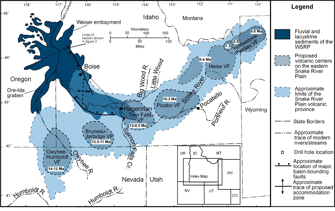
If one were to plot the trajectory from where it's been - to where it is now and extrapolate that out over the next 650,000 years, Montana is your next Huckleberry. For now, it's right where it is. Follow the EQ swarms and geysers.

edit on 31-10-2015 by sageturkey because: Add Pic
a reply to: sageturkey
Ok, so the next hot spot should be in montana, but according to inuit elders in the arctic ( www.naturalnews.com... ) the axis tilt of the earth has moved to the north. is where that crack located right to the south of the projected hotspot?
Ok, so the next hot spot should be in montana, but according to inuit elders in the arctic ( www.naturalnews.com... ) the axis tilt of the earth has moved to the north. is where that crack located right to the south of the projected hotspot?
originally posted by: sketchytink
a reply to: sageturkey
Ok, so the next hot spot should be in montana, but according to inuit elders in the arctic ( www.naturalnews.com... ) the axis tilt of the earth has moved to the north. is where that crack located right to the south of the projected hotspot?
Funny you should mention that. I was going to add to my post that yes, the Earth's axis has tilted a teensy bit, but I don't think it was enough to push it due East. I just knew that you were going to bring that up, shows that you're a thinking person. The crack is approximately 10 miles south of Ten Sleep, so it's East, SouthEast of Yellowstone. There's no seismic activity in that area whatsoever.
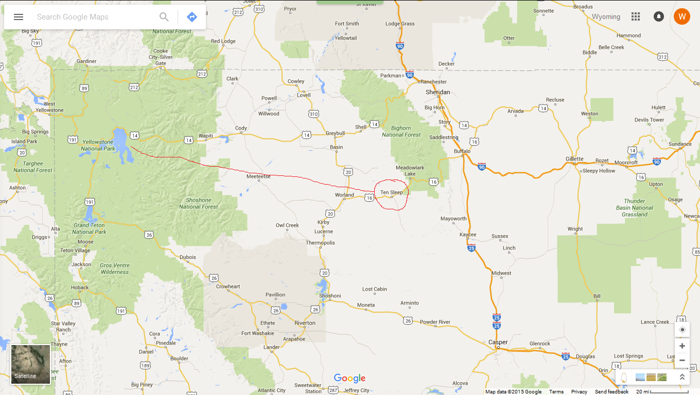
edit on 31-10-2015 by sageturkey because: Highlight Ten Sleep
a reply to: sketchytink
If you're interested in Native tradition which it appears that you are, check out Medicine Wheel in the Bighorns. They're considered sacred by numerous tribes.

Medicine Wheel
If you're interested in Native tradition which it appears that you are, check out Medicine Wheel in the Bighorns. They're considered sacred by numerous tribes.

Medicine Wheel
edit on 31-10-2015 by sageturkey because: Link
a reply to: Aqualung2012
No problem and I totally understand the concern! I mean it looks seismic at first glance and you know it totally could be. What could have happened is there was a tremor and caused all the places eroded from the ground water to collapse.
Especially with the law that was recently passed it definitely could be part of the government trying to hide something.
It's just the official statement makes sense with the type of geology Wyoming has.
a reply to: AmericanRealist
I do have some photos! Unfortunately I only have one on this computer the rest are on another I currently don't have access too. I have one that I'll post that actually pertains to the conversation.
a reply to: asmall89
heck yea man, I was hoping. Man my home is covered in reproduced vacation photos of various places from people I meet online. Much of it is underwater and coral reefs, but I really enjoy the mountains. my two favorite places on Earth, deep below it in the water, and high above on mountains lol.
heck yea man, I was hoping. Man my home is covered in reproduced vacation photos of various places from people I meet online. Much of it is underwater and coral reefs, but I really enjoy the mountains. my two favorite places on Earth, deep below it in the water, and high above on mountains lol.
a reply to: AmericanRealist
Yes I have some great photos that you can use of the landscape. The majority are going to be from southern Wyoming since that's where I spend most of my time due to my location. I can PM some if you would like?
And that law is stupid I'm sure I have plenty of pictures from BLM land that they could have a fuss over. Unless you're a terrible Rancher the land (and water) shouldn't be harmed. The timing of the crack and the law is very coincidental.
Grandfathered in... You guys are killin me...
Took this one a couple weeks ago, enjoy. I have tons of photos of Yellowstone and the Tetons.
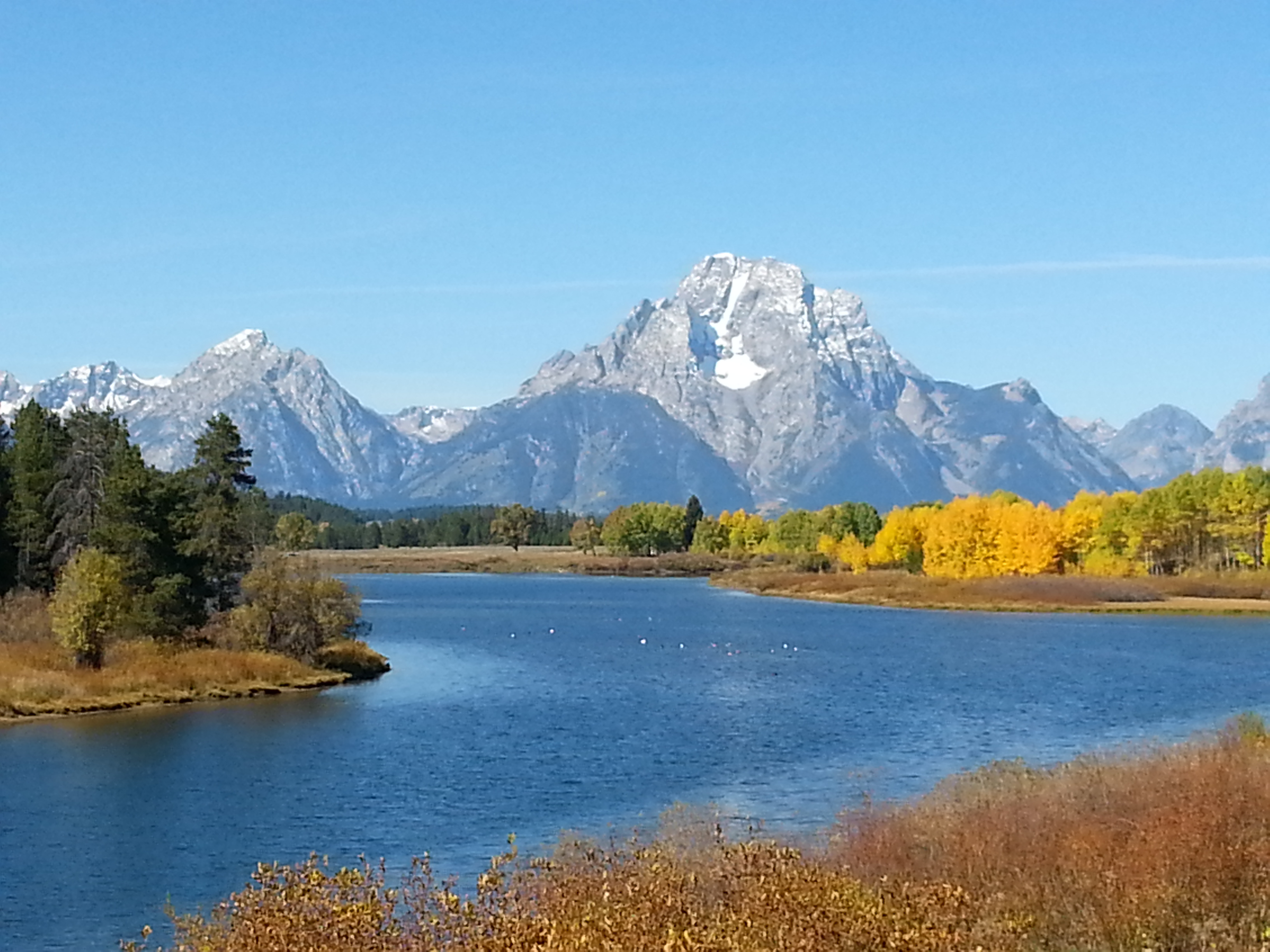
While ATS sleuths worldwide are combing through the exif data to confirm the veracity of the picture, a loud banging can be heard on sageturkey's door.
OPEN UP! IT'S THE CAMERA POLICE!...
Took this one a couple weeks ago, enjoy. I have tons of photos of Yellowstone and the Tetons.

While ATS sleuths worldwide are combing through the exif data to confirm the veracity of the picture, a loud banging can be heard on sageturkey's door.
OPEN UP! IT'S THE CAMERA POLICE!...
edit on 31-10-2015 by sageturkey because: add
To add to that great photo sageturkey here are two I took from one of my various trips there...
I like them because they show just a portion of the extremes you get ..geothermal events, animals, etc..People that havent been there dont realize how active it is..how so many things change about the landscape ..Those are the same type of people that usually think bison , their are no buffalo in North America, or some other large animal running down the road there indicates some pending doom without being aware it is a common occurrence.
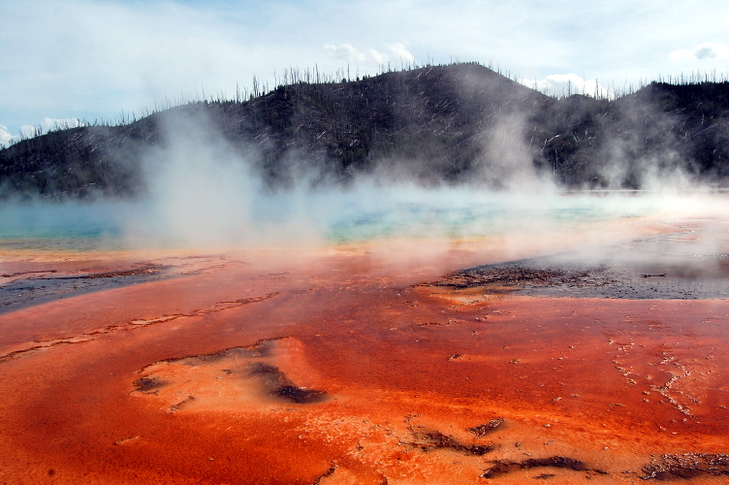
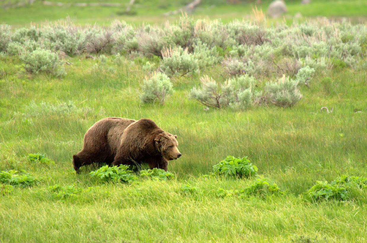
I like them because they show just a portion of the extremes you get ..geothermal events, animals, etc..People that havent been there dont realize how active it is..how so many things change about the landscape ..Those are the same type of people that usually think bison , their are no buffalo in North America, or some other large animal running down the road there indicates some pending doom without being aware it is a common occurrence.


edit on 31-10-2015 by opethPA because: (no reason given)
a reply to: opethPA
Beautiful Opeth, nice Grizz too.
I've seen 9 Bears this year and have photos of them all, but with a crappy phone cam they aren't worth sharing. Do have a few choice videos, though...
Hopefully, sharing a few photos can help to put an end to this crazy notion that somehow it's now illegal to take pictures in Wyoming. If I recall, it's also illegal to wear military clothing if you're not in the armed services.
Only in a very narrow set of circumstances are these regulations invoked.
If someone were to say, capture a screenshot of some crazy sageturkey being goofy in front of the Old Faithful webcam - Is it the person who captured the photo or the NPS itself who's the lawbreaker? Sticky...
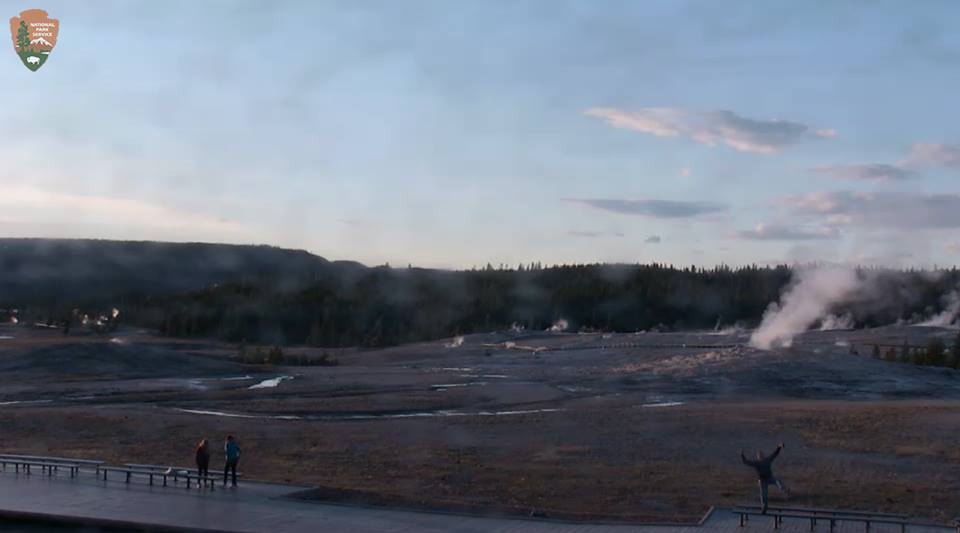
As for our beloved crack, I take a peek at the USGS page daily. Can't recall ever seeing an EQ in the area. In addition, I work in Sheridan and Buffalo quite a bit. I have work partners who have been in Sheridan daily for the last 4 months on a big project. No reports of any tremors...
Beautiful Opeth, nice Grizz too.
I've seen 9 Bears this year and have photos of them all, but with a crappy phone cam they aren't worth sharing. Do have a few choice videos, though...
Hopefully, sharing a few photos can help to put an end to this crazy notion that somehow it's now illegal to take pictures in Wyoming. If I recall, it's also illegal to wear military clothing if you're not in the armed services.
Only in a very narrow set of circumstances are these regulations invoked.
If someone were to say, capture a screenshot of some crazy sageturkey being goofy in front of the Old Faithful webcam - Is it the person who captured the photo or the NPS itself who's the lawbreaker? Sticky...

As for our beloved crack, I take a peek at the USGS page daily. Can't recall ever seeing an EQ in the area. In addition, I work in Sheridan and Buffalo quite a bit. I have work partners who have been in Sheridan daily for the last 4 months on a big project. No reports of any tremors...
Wyoming State Geological Survey, preliminary map of landslides in Wyoming.
Map
Source
Map
Parts of Wyoming have some of the highest landslide densities in the United States. Every year landslides occur in Wyoming, with some causing significant damage or disruption to daily activities These web pages have been generated for two reasons. The first of these is to increase awareness of landslides in Wyoming. The second is to provide citizens with a means to access current landslide data for the state. The landslides were mapped over a 15-year period by the Geologic Hazards Section of the Wyoming State Geological Survey. Over 850 7.5-minute quadrangles have been mapped for landslides. The Wyoming State Geological Survey (WSGS) and the Water Resources Data System (WRDS) are in the process of generating coverages of them for Wyoming.
Source
a reply to: sageturkey
Thinking back to the wording in the bill, I believe it was "entering the area for the purpose of collecting data, and the act thereof," which has actually been banned. (I'm paraphrasing of course)
Maybe this means that any "data collected" -in itself- is not illegal, but you don't want to get caught attempting to record it. Either way, it sucks...
I don't want to risk shifting too much towards the law aspect rather than the "gash," so I'll just say this: I'll be interested to see how many more photos/videos of this thing get published. There only seems to be a few floating around the various media sources as of right now, and I'd bet there won't be many more.
This land shift is actually a great opportunity to put this law to the test. It serves as "data bait," and will definitely give us a clear and immediate picture of exactly how they intend to enforce this law, and to what degree.
edit on PMq000000pmSaturday00000010420 by Aqualung2012 because: (no reason given)
a reply to: Aqualung2012
It is truth that you speak kimosabe.
I was pretty appalled when I first heard about the bill.
I was also appalled when the governor upheld the Civil forfeiture act.
Not the shining beacon of freedom that I have always viewed Wyoming as.
I would imagine that if there isn't any more drastic movement at the gash, then media coverage will move on. I do expect though, that people will be keeping a close eye on it and if it does enlarge I would hope that it gets more attention.
a reply to: Aqualung2012
Discussion is always important, and I truly agree with you here. In essence my point was as explained and put into proper perspective for me by a Physicist friend..
If we all boarded a ride to space and hovered a millions years above looking down? All would still be happening, regardless to any one observing, talking about it or expecting it.../not expecting it.
Dynamic changes are natural to Earth. Man is just come to a point where we sigh a collective sigh of "Oh my God! Look whats happening!".
North Salt lake comes to mind, the bench landslide. Also a landslide in Oso Washington very recent. A huge area was washed of life there, and also
this Yellowstone Bighorn. I'd bet on Yellowstone being the contributing cause. There was another one over in California I think in Imperial Valley.
Also don't forget the abundance of sink holes.
This slide has a singular characteristic almost like Monument Valley, these dirt spires not yet fallen. But you see........ no your not allowed...
This slide has a singular characteristic almost like Monument Valley, these dirt spires not yet fallen. But you see........ no your not allowed...
new topics
-
January 6th report shows disturbing trend (nobody is shocked)
US Political Madness: 36 minutes ago -
Inexplicable military simulation - virtual reality showdown in the night..
The Gray Area: 1 hours ago -
The Truth about Migrant Crime in Britain.
Social Issues and Civil Unrest: 1 hours ago -
Trudeau Resigns! Breaking
Other Current Events: 3 hours ago -
Live updates: Congress meets to certify Trump's presidential election victory
US Political Madness: 4 hours ago -
Gravitic Propulsion--What IF the US and China Really Have it?
General Conspiracies: 5 hours ago -
Greatest thing you ever got, or bought?
General Chit Chat: 5 hours ago
top topics
-
Trudeau Resigns! Breaking
Other Current Events: 3 hours ago, 20 flags -
Live updates: Congress meets to certify Trump's presidential election victory
US Political Madness: 4 hours ago, 12 flags -
OK this is sad but very strange stuff
Paranormal Studies: 16 hours ago, 9 flags -
Islam And A Book Of Lies
Religion, Faith, And Theology: 17 hours ago, 6 flags -
Gravitic Propulsion--What IF the US and China Really Have it?
General Conspiracies: 5 hours ago, 6 flags -
The Truth about Migrant Crime in Britain.
Social Issues and Civil Unrest: 1 hours ago, 5 flags -
Greatest thing you ever got, or bought?
General Chit Chat: 5 hours ago, 3 flags -
January 6th report shows disturbing trend (nobody is shocked)
US Political Madness: 36 minutes ago, 3 flags -
Inexplicable military simulation - virtual reality showdown in the night..
The Gray Area: 1 hours ago, 0 flags
active topics
-
-@TH3WH17ERABB17- -Q- ---TIME TO SHOW THE WORLD--- -Part- --44--
Dissecting Disinformation • 3952 • : AianawaQ1320 -
Trudeau Resigns! Breaking
Other Current Events • 49 • : HeyYouNotYouYou -
Live updates: Congress meets to certify Trump's presidential election victory
US Political Madness • 17 • : Dalamax -
Greatest thing you ever got, or bought?
General Chit Chat • 19 • : Dalamax -
Inexplicable military simulation - virtual reality showdown in the night..
The Gray Area • 1 • : lilzazz -
January 6th report shows disturbing trend (nobody is shocked)
US Political Madness • 1 • : xuenchen -
Gravitic Propulsion--What IF the US and China Really Have it?
General Conspiracies • 7 • : Mantiss2021 -
The Truth about Migrant Crime in Britain.
Social Issues and Civil Unrest • 10 • : network dude -
Musk calls on King Charles III to dissolve Parliament over Oldham sex grooming gangs
Mainstream News • 195 • : Oldcarpy2 -
Elon Musk futurist?
Dreams & Predictions • 37 • : lilzazz
