It looks like you're using an Ad Blocker.
Please white-list or disable AboveTopSecret.com in your ad-blocking tool.
Thank you.
Some features of ATS will be disabled while you continue to use an ad-blocker.
share:
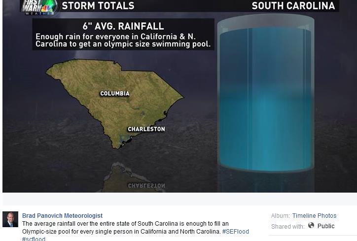
Why you don't drive into water!!!!! Turn around don't drown!!!!
Current SCDOT Road Closures pdf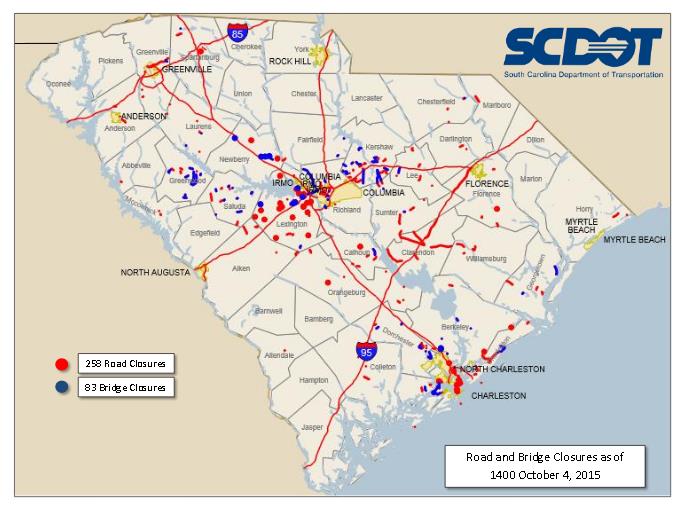
Pic of the Semmes Rd dam failure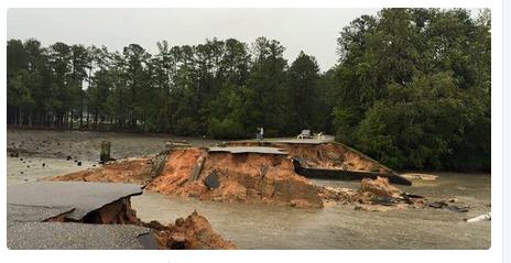
@Ft Jackson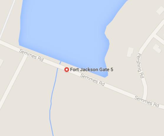

Current SCDOT Road Closures pdf

Pic of the Semmes Rd dam failure

@Ft Jackson

Wow. Sumter Co SC:
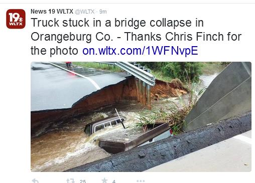
Pearson Road - Briar Branch (creek) bridge out -south of Sumter btwn Privateer and Paxville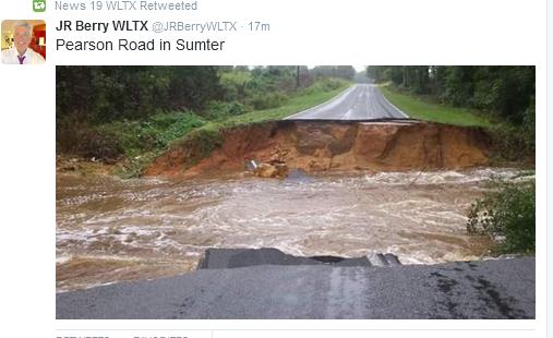
Porter Cross Rd - Doby's Mill Fire Station being evac b/c rising water Spear's Creek - just south of I20, SE of Camden
Burkett Street in Sumter just south of I20 --saw pic but can't find - water up to windows
Wow--SC is well known for our #ty roads before this b/c we have low gas tax, but now --gawd almighty - there just isn't any roads/bridges on these secondary roads --how they hell they going to fix this -- and how long will it take ??? months?? and not just one county - it's state freaking wide from Charleston to Columbia, GA to NC.
Pearson Road - Briar Branch (creek) bridge out -south of Sumter btwn Privateer and Paxville

Porter Cross Rd - Doby's Mill Fire Station being evac b/c rising water Spear's Creek - just south of I20, SE of Camden
Burkett Street in Sumter just south of I20 --saw pic but can't find - water up to windows
Wow--SC is well known for our #ty roads before this b/c we have low gas tax, but now --gawd almighty - there just isn't any roads/bridges on these secondary roads --how they hell they going to fix this -- and how long will it take ??? months?? and not just one county - it's state freaking wide from Charleston to Columbia, GA to NC.
I know these pics are mostly Columbia and Sumter areas which aren't near I95 so posts aren't so much about I95.
But these areas are up stream of the Santee Lakes of which is a major I95 bridge and Sumter's Black River swamps which has many bridges on I95. All this has to go downstream at sometime. I apologize if header seems misleading.
Gov Haley's presser right now - planing on or have closed multiple interstates going into Columbia and Charleston;I26 going into both Charleston and Columbia; I 126 Broad River bridge??; portions of I 20 (prob crossing Broad River) ; I77 going into Columbia; state offices and local schools closed Mon to give DOT a chance to access damage. She just said "just plan that roads are closed today and tomorrow - stay home". WOW. Epic.
Prayers go out to all in this dangerous situation.
Nothing to add right now, just showing support and to let you know I am here and reading .
Nothing to add right now, just showing support and to let you know I am here and reading .
edit on pm1031pmSun, 04 Oct 2015 15:38:53 -0500 by
antar because: (no reason given)
OK, multiple curfews in effect = 6pm -6am unless you have to go to work or ER personnel - Sumter Co; Fairfield Co; Clarendon Co; Richland Co.;
Lexington Co.
Lexington Co Sheriff's Office is evac ppl that live w/in 1/4 mile of Saluda River & Congaree River per
Lexington Co SO FB pg
Prob b/c of this - have to release the water coming down - Lake Murray is THE Major huge power generating lake above Columbia with flood gates thank god
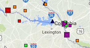
the two red dots =
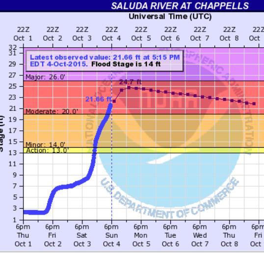
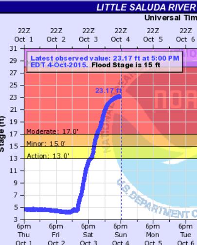
plus the two orange square which are 2 small creeks feeding Saluda also in flood stage
Lexington Co Sheriff's Office is evac ppl that live w/in 1/4 mile of Saluda River & Congaree River per
Secondly, we are recommending a voluntary evacuation of homes within 1/4 mile of the Lexington County banks of the Saluda and Congaree rivers. SCANA will be releasing water from Lake Murray, which will cause river levels to rise.
Lexington Co SO FB pg
Prob b/c of this - have to release the water coming down - Lake Murray is THE Major huge power generating lake above Columbia with flood gates thank god

the two red dots =


plus the two orange square which are 2 small creeks feeding Saluda also in flood stage
ok add Florence Co; Darlington Co; to the list of curfews
Local WPDE ABC15 twitter feed
Florence Co also evac ppl from around Black Creek which runs under i95 above the i20 exchange.
This creek feeds into the Pee Dee River on the North Side of Florence.
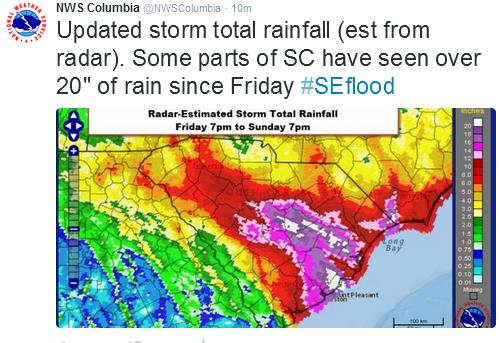
Which is making me wonder with all this new rain if they will up the ante on i95 and shut it down above where it crosses the Pee Dee River near the state line??? That area has lotts of swamp area to spread out, so it's not the same hydraulics as in Columbia plus they haven't rec'd 20" of rain either - yet. Fingers crossed.
a reply to: SCGrits
Hello Fellow-South Carolinian,
I'm in the upstate, so things are not as critical. We only got about 7 inches of rain, instead of 15. Hope you are safe. My mom lives in the midlands, but NE of Columbia (in Camden.) There is flooding there, but her house is pretty elevated and she stocked up on things, so she's just waiting it out, hoping she doesn't lose power like so many others have.
I found a slideshow on WISTV website that really blew me away:
Flooding in Columbia
On there I also learned that the Lake Murray Dam floodgates, operational since the 60's, have only ever been used to test them... until this weekend. AND, concerning the Broad River Diversion Dam, which is overflowing like mad, it says...
"This is the dam that was built during the Civil War. It's at the end of the Riverwalk off of Broad River Rd, where the canal starts. You can see that the dam is completely covered."
Crazy, crazy stuff.
Another pond failure. Looks to be just before dark thirty. Is this going to go on all night???
This was west of Lugoff, btwn Blytheville and Camden per Lugoff Fire Chief Ray --
Lancaster Co swift water rescue going to help! Yeah go Lancaster!!
This was west of Lugoff, btwn Blytheville and Camden per Lugoff Fire Chief Ray --
Just lost Getty's Pond Dam off Kellytown Rd-Green Hill Golf Course under water. Ponds cannot hold water
Lancaster Co swift water rescue going to help! Yeah go Lancaster!!
a reply to: new_here
Wow, thanks for that. Did not know that! I'll keep my fingers crossed for your mom. Camden is just south of us; we've just had high winds here all day; hope she's on the high side of Camden and not near any ponds!! My folks are in Sumter/Florence area. Mom says she has a frog pond for a yard but the house is ok and the bridge over the swamp seems to be holding as is my aunts pond nearby. My folks in Charleston and Columbia haven't floated away yet either. Fingers crossed!!
Wow, thanks for that. Did not know that! I'll keep my fingers crossed for your mom. Camden is just south of us; we've just had high winds here all day; hope she's on the high side of Camden and not near any ponds!! My folks are in Sumter/Florence area. Mom says she has a frog pond for a yard but the house is ok and the bridge over the swamp seems to be holding as is my aunts pond nearby. My folks in Charleston and Columbia haven't floated away yet either. Fingers crossed!!
originally posted by: SCGrits
a reply to: new_here
Wow, thanks for that. Did not know that! I'll keep my fingers crossed for your mom. Camden is just south of us; we've just had high winds here all day; hope she's on the high side of Camden and not near any ponds!! My folks are in Sumter/Florence area. Mom says she has a frog pond for a yard but the house is ok and the bridge over the swamp seems to be holding as is my aunts pond nearby. My folks in Charleston and Columbia haven't floated away yet either. Fingers crossed!!
Mom lives on Lake Wateree, which sounds like bad news. But... they lowered the lake level in preparation for the impending rain, and her lot slopes way up so at least for now, she is fine. Like you say... fingers crossed!
What's going on in Columbia just blows me away. I've driven thru there so many times in my life and NEVER seen flooding issues. Charleston, even though the situation there is unprecedented, still it IS low-lying and 'no stranger to flooding.' But Columbia... never seen anything like this. Really bizarre.
Glad your folks are safe as well!
New Here ---thank you so much for that link -- wow - lotta pics I had not seen.
originally posted by: SCGrits
New Here ---thank you so much for that link -- wow - lotta pics I had not seen.
I know... the sheer number of roads and bridges washed out or crumbling away! How will those folks be able to get around even when the water subsides? How long will it take to make all of those roads passable again?
And all of the cars and houses under water. People will need to rebuild their lives from all of the destruction.
a reply to: new_here
I know what you mean. My sig other used to work in Columbia and drive up & down those roads all the time. He's been here since the '70s and never seen anything like it. He was blown away by those pics coming outta Columbia.
Good thing about Lake Wateree is that it's the lower end of the Catawba River which is highly dam controlled by Duke Power all the way into NC foothills and like you said we've had rain here in the upstate but not like Charleston or Columbia so there's nothing too abnormal coming downstream to your Mom. I think I read somewhere that Duke still had lots of capacity in Lake Wylie and Lake Norman so they can stand to hold the water up here and not release it downstream. I think the Catawba is about the only River in SC without a red box on it on the hydro maps!!
a reply to: SCGrits
You clearly understand a whole lot more about the connectivity and interactions of the rivers & lakes in SC, so what can you tell me about the Columbia situation? Is it because they couldn't regulate/release water from, say, Broad River ahead of time to prepare for this, or just what? I mean, I understand what you're saying about Lake Wateree, but Mom has gotten about as much rain as Columbia, but her neck of the woods is not as affected.
You clearly understand a whole lot more about the connectivity and interactions of the rivers & lakes in SC, so what can you tell me about the Columbia situation? Is it because they couldn't regulate/release water from, say, Broad River ahead of time to prepare for this, or just what? I mean, I understand what you're saying about Lake Wateree, but Mom has gotten about as much rain as Columbia, but her neck of the woods is not as affected.
a reply to: new_here
I know. It takes forever for SCDOT to fix the roads when everything is normal. I know the counties aren't going to be able to pony up the $$$ to fix the sheer number of bridges out, they already have their road budgets planned out 5 yrs in advance. This mess has put everything and everyone who depends on those roads into a tailspin and then some. Like what about the school buses?? Mail Delivery?? Food and goods delivery to merchants like Walmart and Food Lion grocery??
Mom's Dr office has already called her and cx her dr appt next week in Florence. They usually use that stretch of i95 that's closed!
I kept telling my sig other today that this is one day that I'm glad I don't work in Emergency management!!!
the sheer number of roads and bridges washed out or crumbling away! How will those folks be able to get around even when the water subsides? How long will it take to make all of those roads passable again?
I know. It takes forever for SCDOT to fix the roads when everything is normal. I know the counties aren't going to be able to pony up the $$$ to fix the sheer number of bridges out, they already have their road budgets planned out 5 yrs in advance. This mess has put everything and everyone who depends on those roads into a tailspin and then some. Like what about the school buses?? Mail Delivery?? Food and goods delivery to merchants like Walmart and Food Lion grocery??
Mom's Dr office has already called her and cx her dr appt next week in Florence. They usually use that stretch of i95 that's closed!
I kept telling my sig other today that this is one day that I'm glad I don't work in Emergency management!!!
a reply to: new_here
Thank you and yes I do know more than the avg bear about SC riverbasins - BA in Env Studies =lots of papers written!!
I think the biggest contrib factor in Columbia was
If I remember right, DHEC has been fussing with the Home Owner Assoc (HOA) in the Arkadia Lakes area over who's responsible for dam maintenance of those earthen dams that collapsed. It was kinda in limbo - ergo no one was really maintaining them. I'll have to find the article for you later.
Reason I know was b/c we had a similar problem with an upstream dam that was threatening some of our property and DHEC closed the road b/c of eminent failure threat. Believe you me I did a lot of research on earthen dam failures in SC. Turns out the ppl that own the pond lived in TX; 80+ yo & suffered from Alzheimers and the kids were bickering over who was to maintain the dam - & no one was doing it. In which case DHEC stepped in, either fix it or drain it yourself or we will and send you the bill!!
One thing I learned from that episode was 1) absolutely no trees should be on a dam - wind blows- soft ground- tree topples and takes a chunk of dam with it=catastrophic failure. Also - no driving on dam - compacts the soil and weakens it. So it could of been any of those things, or the spill way clogged or jammed with debris, in which case dam would be topped ie over flow, eroding the top of the dam.
I'm sure there will be a megga finger pointing session amongst the PTB once the water has receded, but watch the language they will use in the press - I've noticed it all ready today --said dam did not fail, it was topped
Failed=mega liability vs topped = implies act of God -ie megga rain =not so much liability.
It's also where she is on the ridge line. The closer/higher you live on a ridge line the less water you have to deal with (you just have to deal with mudslides like in the Mts !!) Every one in line below you will have more water & more ponds to deal with.
I live on a ridge line --if look at all the creeks on my side of the hwy they all flow into the Lynches River basin and on into the PeeDee on to Georgetown.
Just across the road, they all flow into the Catawba River basin, which is not that far -10 miles? on into Wateree which goes into the Congagree Swamp into which also the Saluda and Broad rivers flow, of which all goes into the Santee Lakes -Lake Marion & Lake Moultrie.
Camden is the start of the fall line - north of Camden you start going up in elevation--ever been on hwy 97 to Great Falls? Very hilly; go south of Camden to hwy 521 to Sumter - very flat.
Yes there is a diff btwn fall line and ridge line - fall line is geologic feature that runs thru the middle of SC from GA on to Va I think - google images it and you'll get a feel for it; ridge line is what defines into what river basins the creeks will flow; there are several in SC
What I saw this AM was for the most part a catastrophic cascade of pond failures - the top one went, then the next one, then the next one and depending on the depth and cubic sq ft of load determines how much of a wall of water was coming down the pike. Shallow lake - not so much---Lake Murray --better make you peace with God my friend!!!
I think these guys were in between the two.
I hope this makes sense?? and that I didn't bore you to death!!Got any more questions-happy to answ if I can
the connectivity and interactions of the rivers & lakes in SC, so what can you tell me about the Columbia situation? Is it because they couldn't regulate/release water from, say, Broad River ahead of time to prepare for this, or just what? I mean, I understand what you're saying about Lake Wateree, but Mom has gotten about as much rain as Columbia, but her neck of the woods is not as affected.
Thank you and yes I do know more than the avg bear about SC riverbasins - BA in Env Studies =lots of papers written!!
I think the biggest contrib factor in Columbia was
- The sheer volume of rain training over the same area over and over
- catastrophic cascading series of earthen dam failures- more on this in a sec
- I don't think that the Broad River has any or little dam controls
- Saluda has some dam controls, but not as much as say the Catawba
If I remember right, DHEC has been fussing with the Home Owner Assoc (HOA) in the Arkadia Lakes area over who's responsible for dam maintenance of those earthen dams that collapsed. It was kinda in limbo - ergo no one was really maintaining them. I'll have to find the article for you later.
Reason I know was b/c we had a similar problem with an upstream dam that was threatening some of our property and DHEC closed the road b/c of eminent failure threat. Believe you me I did a lot of research on earthen dam failures in SC. Turns out the ppl that own the pond lived in TX; 80+ yo & suffered from Alzheimers and the kids were bickering over who was to maintain the dam - & no one was doing it. In which case DHEC stepped in, either fix it or drain it yourself or we will and send you the bill!!
One thing I learned from that episode was 1) absolutely no trees should be on a dam - wind blows- soft ground- tree topples and takes a chunk of dam with it=catastrophic failure. Also - no driving on dam - compacts the soil and weakens it. So it could of been any of those things, or the spill way clogged or jammed with debris, in which case dam would be topped ie over flow, eroding the top of the dam.
I'm sure there will be a megga finger pointing session amongst the PTB once the water has receded, but watch the language they will use in the press - I've noticed it all ready today --said dam did not fail, it was topped
Failed=mega liability vs topped = implies act of God -ie megga rain =not so much liability.
It's also where she is on the ridge line. The closer/higher you live on a ridge line the less water you have to deal with (you just have to deal with mudslides like in the Mts !!) Every one in line below you will have more water & more ponds to deal with.
I live on a ridge line --if look at all the creeks on my side of the hwy they all flow into the Lynches River basin and on into the PeeDee on to Georgetown.
Just across the road, they all flow into the Catawba River basin, which is not that far -10 miles? on into Wateree which goes into the Congagree Swamp into which also the Saluda and Broad rivers flow, of which all goes into the Santee Lakes -Lake Marion & Lake Moultrie.
Camden is the start of the fall line - north of Camden you start going up in elevation--ever been on hwy 97 to Great Falls? Very hilly; go south of Camden to hwy 521 to Sumter - very flat.
Yes there is a diff btwn fall line and ridge line - fall line is geologic feature that runs thru the middle of SC from GA on to Va I think - google images it and you'll get a feel for it; ridge line is what defines into what river basins the creeks will flow; there are several in SC
What I saw this AM was for the most part a catastrophic cascade of pond failures - the top one went, then the next one, then the next one and depending on the depth and cubic sq ft of load determines how much of a wall of water was coming down the pike. Shallow lake - not so much---Lake Murray --better make you peace with God my friend!!!
I think these guys were in between the two.
I hope this makes sense?? and that I didn't bore you to death!!Got any more questions-happy to answ if I can
edit on 4-10-2015 by SCGrits because: (no reason given)
new topics
-
January 6th report shows disturbing trend (nobody is shocked)
US Political Madness: 30 minutes ago -
Inexplicable military simulation - virtual reality showdown in the night..
The Gray Area: 58 minutes ago -
The Truth about Migrant Crime in Britain.
Social Issues and Civil Unrest: 1 hours ago -
Trudeau Resigns! Breaking
Other Current Events: 3 hours ago -
Live updates: Congress meets to certify Trump's presidential election victory
US Political Madness: 4 hours ago -
Gravitic Propulsion--What IF the US and China Really Have it?
General Conspiracies: 5 hours ago -
Greatest thing you ever got, or bought?
General Chit Chat: 5 hours ago
top topics
-
Trudeau Resigns! Breaking
Other Current Events: 3 hours ago, 19 flags -
Live updates: Congress meets to certify Trump's presidential election victory
US Political Madness: 4 hours ago, 11 flags -
OK this is sad but very strange stuff
Paranormal Studies: 16 hours ago, 9 flags -
Islam And A Book Of Lies
Religion, Faith, And Theology: 17 hours ago, 6 flags -
Gravitic Propulsion--What IF the US and China Really Have it?
General Conspiracies: 5 hours ago, 6 flags -
The Truth about Migrant Crime in Britain.
Social Issues and Civil Unrest: 1 hours ago, 5 flags -
Greatest thing you ever got, or bought?
General Chit Chat: 5 hours ago, 3 flags -
January 6th report shows disturbing trend (nobody is shocked)
US Political Madness: 30 minutes ago, 2 flags -
Inexplicable military simulation - virtual reality showdown in the night..
The Gray Area: 58 minutes ago, 0 flags
active topics
-
Greatest thing you ever got, or bought?
General Chit Chat • 19 • : Dalamax -
Live updates: Congress meets to certify Trump's presidential election victory
US Political Madness • 16 • : CriticalStinker -
Inexplicable military simulation - virtual reality showdown in the night..
The Gray Area • 1 • : lilzazz -
January 6th report shows disturbing trend (nobody is shocked)
US Political Madness • 1 • : xuenchen -
Gravitic Propulsion--What IF the US and China Really Have it?
General Conspiracies • 7 • : Mantiss2021 -
The Truth about Migrant Crime in Britain.
Social Issues and Civil Unrest • 10 • : network dude -
Musk calls on King Charles III to dissolve Parliament over Oldham sex grooming gangs
Mainstream News • 195 • : Oldcarpy2 -
Elon Musk futurist?
Dreams & Predictions • 37 • : lilzazz -
-@TH3WH17ERABB17- -Q- ---TIME TO SHOW THE WORLD--- -Part- --44--
Dissecting Disinformation • 3951 • : angelchemuel -
Trudeau Resigns! Breaking
Other Current Events • 47 • : Flyingclaydisk

