It looks like you're using an Ad Blocker.
Please white-list or disable AboveTopSecret.com in your ad-blocking tool.
Thank you.
Some features of ATS will be disabled while you continue to use an ad-blocker.
share:
originally posted by: ugmold
I can never understand why people bulk up at the Grocery Store for a storm, I mean at most it will be one day until you can get back there.
With two feet of snow and wind at 70MPH in Connecticut .. it'll be more than one day before people can get to the store. And two or three feet of snow in NYC ... YIKES! Get the food now because it'll be days and days before the roads are open and even when they get open it'll be difficult traveling.
The news is now reporting that NYC is expecting up to 30 inches.
That's two and a half feet.
This is a clipper system. We aren't supposed to get snow totals like this in a clipper!!
originally posted by: _BoneZ_
You don't have to waste gas or electric to turn up the heat to warm the pipes. You just need to let the water slowly trickle out of the faucets. Constantly moving water will keep the pipes from freezing.
We do that but it doesn't always work. The upstairs bathroom kind of hangs out over the porch a bit. The house is 60 years old and the insulation is scarce and poor. Turning up the heat and opening the back panel off the tub/shower pipes seems to help.
Philly ... we are now looking at 14-24 inches.
Philadelphia CBS Local
Philadelphia CBS Local
* Snow accumulations... 14 to 24 inches.
* Timing... snow develops between midnight tonight and 5 am Monday,
then it continues through the day. The snow is expected to become
heavy at times late Monday afternoon through Tuesday morning
when snowfall rates of a couple of inches per hour can occur at
times, then taper off during Tuesday afternoon.
NYC ... you are looking at up to THREE FEET
NBC New York
NBC New York
A paralyzing blizzard with white-out conditions is expected to dump more than two feet of snow on the Tri-State region, and Mayor de Blasio is urging New Yorkers to "prepare for something worse than we have seen before."
The storm is expected to dump 24 to 36 inches of snow on New York City and its surrounding suburbs, beginning Monday and continuing through Tuesday night, according to Storm Team 4.
a reply to: ugmold
You stock up a little because with the amounts they are talking about it might be a few days before the plows get your roads open depending on where you live. I know our city services don't even bother with plowing the road that runs in front of our house. I'm so glad our city tax rates are so high ... Makes one wonder just exactly what it is we pay for.
Or if you are more rural, it can take days before the county plows get to you, and if you're talking powder + wind, the road might get opened, but it will just get blown over shut again as soon as the plow comes through.
Well this should make for a fun few days..
Live in South Philly have to go near Trenton for work tomorrow.
Snowmageddon incoming!
Live in South Philly have to go near Trenton for work tomorrow.
Snowmageddon incoming!
Note to self: Don't be lickin' phone poles for the next week.
Well...., seems like it got a bit more serious now. The boss just called me from home (I guess), with some instructions. We will be running a short
schedule tomorrow. Last time we run these procedures was Sandy coming.
By other hand, just read on NJ.com that it will be a "All or nothing scenario". Hmmmm, just can't wait. Camera ready.
Please, be safe folks.
By other hand, just read on NJ.com that it will be a "All or nothing scenario". Hmmmm, just can't wait. Camera ready.
Please, be safe folks.
I'm in Rhode Island. Got my groceries and munchies, I'm all set.
I'm looking at all the different weather forecasts for the area. Each has a different amount. They can't agree. I guess we'll know in 48 hours
when it's all done.
originally posted by: FlyersFan
Philly ... we are now looking at 14-24 inches.
Philadelphia CBS Local
* Snow accumulations... 14 to 24 inches.
* Timing... snow develops between midnight tonight and 5 am Monday,
then it continues through the day. The snow is expected to become
heavy at times late Monday afternoon through Tuesday morning
when snowfall rates of a couple of inches per hour can occur at
times, then taper off during Tuesday afternoon.
We've already been issued a Level 2 snow alert in Pittsburgh and surrounding areas. Thank goodness I don't have to drive, but if I do, even more thank goodness I have ABS with AWD!
3-5 Inches to be expected, 5-8 in some ridge regions
edit on 1/25/2015 by Anyafaj because: (no reason given)
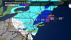
I am in the main target area here in Massachusetts. Am I going crazy over it? Ahhh...no. Lived in this area and around Boston for 50 yrs. It's winter,
we get snow. Will I think it'll be the "worst storm ever", not by a long shot. Blizzard of '78 was the worst I ever lived through. The main highway
around Boston (rte 128/95) was filled with abandoned cars, buried to the doors in snow. We were snowbound for about a week in the house. Much of that
time without power, heat was a wood stove, light was candles or battery operated lanterns. Listening to the reports on the radio, while playing cards
and board games.
Blizzard of 78


This blizzard will last one day, we'll be back to work and on the road Wednesday, Thursday if the state drags their feet in order to get more $$ from the Feds.
Blizzard of 78


This blizzard will last one day, we'll be back to work and on the road Wednesday, Thursday if the state drags their feet in order to get more $$ from the Feds.
edit on 1/25/2015 by Krakatoa because: (no reason given)
It seems to me we could build some kind of big coherent RF energy transmitting array way up North in the polar region and kind of steer these low
pressure areas away from populated areas by heating the ionosphere in just the right spots. In theory it could work. What do you all think?
originally posted by: Anyafaj
originally posted by: FlyersFan
Philly ... we are now looking at 14-24 inches.
Philadelphia CBS Local
* Snow accumulations... 14 to 24 inches.
* Timing... snow develops between midnight tonight and 5 am Monday,
then it continues through the day. The snow is expected to become
heavy at times late Monday afternoon through Tuesday morning
when snowfall rates of a couple of inches per hour can occur at
times, then taper off during Tuesday afternoon.
We've already been issued a Level 2 snow alert in Pittsburgh and surrounding areas. Thank goodness I don't have to drive, but if I do, even more thank goodness I have ABS with AWD!
3-5 Inches to be expected, 5-8 in some ridge regions
I'm near Pittsburgh here by about 30 minutes give or take, SE, and since I last posted that at about midnight EST, we've already gotten about an inch and a half to 2 inches and the plows have been through 3 times already. We're on a weathr alert till 1pm at least.
Any more updates? I'm bored at work here in Toronto and love me some weather doom. Flurries here. Same system.
Well ... last nights clipper totally missed us. So we can shave 3 inches off the expected totals. The 'Nor Easter is supposed to show up here this
afternoon and go into the night. I'm seriously doubting it's going to be what they say. At least not here ...
They have given it the official name of "Superstorm Juno" according to a local radio station. Last time they did that it was "White Juan",and it did shut everyone down for days. Fun times on the way...
originally posted by: Trueman
originally posted by: AccessDenied
They are calling it the "winter whallop" here in Nova Scotia.
When they give a name to this things is a bad sign. Like "Thundersnow" or "Polar Vortex".
new topics
-
Trash To Treasure: Dumpster Diving With Mike The Scavenger
General Chit Chat: 11 minutes ago -
Danish Prime Minister said to keep 3 days worth of canned goods on hand
World War Three: 43 minutes ago -
The hunter has become the hunted
Politicians & People: 3 hours ago -
Trump's idea to make Canada the 51st US state: 'Potential is massive'
Mainstream News: 4 hours ago -
Well this is Awkward .....
Mainstream News: 9 hours ago -
Kurakhove officially falls. Russia takes control of major logistics hub city in the southeast.
World War Three: 10 hours ago
top topics
-
The hunter has become the hunted
Politicians & People: 3 hours ago, 18 flags -
Well this is Awkward .....
Mainstream News: 9 hours ago, 17 flags -
Trump's idea to make Canada the 51st US state: 'Potential is massive'
Mainstream News: 4 hours ago, 12 flags -
Liberal Madness and the Constitution of the United States
US Political Madness: 16 hours ago, 10 flags -
Kurakhove officially falls. Russia takes control of major logistics hub city in the southeast.
World War Three: 10 hours ago, 9 flags -
Danish Prime Minister said to keep 3 days worth of canned goods on hand
World War Three: 43 minutes ago, 0 flags -
Trash To Treasure: Dumpster Diving With Mike The Scavenger
General Chit Chat: 11 minutes ago, 0 flags
active topics
-
Trump's idea to make Canada the 51st US state: 'Potential is massive'
Mainstream News • 32 • : network dude -
New York Governor signs Climate Law that Fines Fossil Fuel Companies
US Political Madness • 30 • : Echo007 -
Trash To Treasure: Dumpster Diving With Mike The Scavenger
General Chit Chat • 0 • : charlest2 -
Liberal Madness and the Constitution of the United States
US Political Madness • 14 • : Flyingclaydisk -
Danish Prime Minister said to keep 3 days worth of canned goods on hand
World War Three • 1 • : Kawrider9ish -
‘Something horrible’: Somerset pit reveals bronze age cannibalism
Ancient & Lost Civilizations • 31 • : Xtrozero -
Kurakhove officially falls. Russia takes control of major logistics hub city in the southeast.
World War Three • 7 • : nugget1 -
Meta Llama local AI system is scary good
Science & Technology • 33 • : ArMaP -
Plane Crash Today --Azerbaijanian E190 passenger jet
Mainstream News • 48 • : GENERAL EYES -
Well this is Awkward .....
Mainstream News • 26 • : NeedInfo

