It looks like you're using an Ad Blocker.
Please white-list or disable AboveTopSecret.com in your ad-blocking tool.
Thank you.
Some features of ATS will be disabled while you continue to use an ad-blocker.
Schoolteacher discovers accurate map of northern hemisphere inside Viking-age artifact (OOPARTs)
page: 1share:
A japanese schoolteacher has discovered what appears to be a very accurate map of the of northern hemisphere inside a Viking-age artifact from
Vestervang, Denmark. The artifact is currently owned by the British Museum and labled as a "brooch". The artifact has been dated to 850-950 AD and has
an exact twin copy that was unearthed in Norway (note that the video is not clear on if the twin has a map on the backside too).
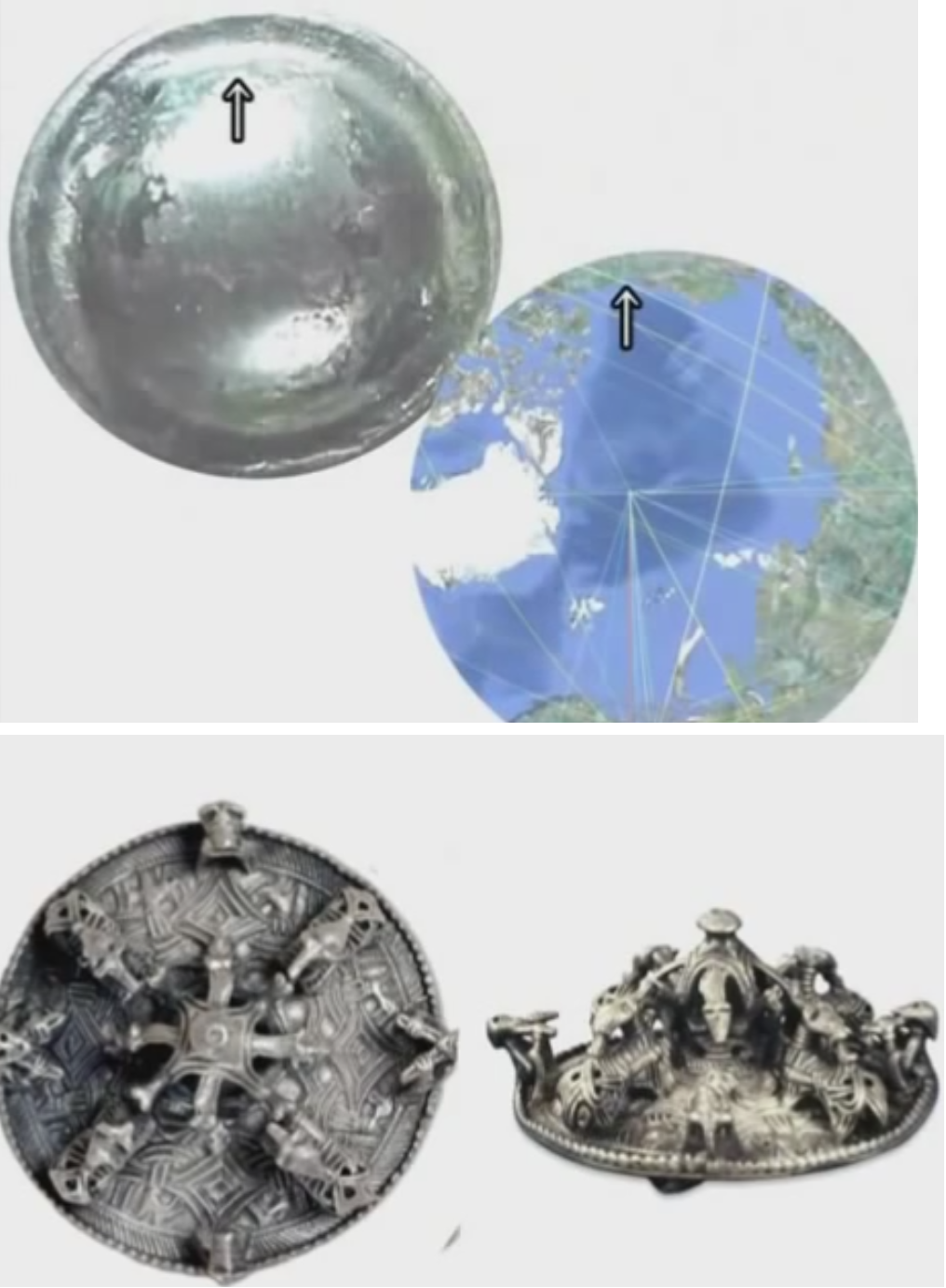
He presents his findings at about 5 minutes into this video:
If this is a real find then this - in my opinion - would rewrite what modern archeologists believe the ancients were capable of. This maps has features that could only have been made possible modern maths (for the globe projection) and technology.
Personally, I cannot verify the authenticity of the artifact.
Comments?
-MM
edit on 27-12-2014 by MerkabaMeditation because: (no reason given)
edit on 27-12-2014 by MerkabaMeditation because: (no reason
given)
I wonder how they got the knowledge of such a precise map of the Northern Hemisphere...
On a serious note, who is behind the biggest cover up of Mankinds history? which is of course the cover up of Ancient Man not being so primitive after all..
On a serious note, who is behind the biggest cover up of Mankinds history? which is of course the cover up of Ancient Man not being so primitive after all..
I am all about OOPARTs but I think this is a stretch.
Unfortunately like most of the others...
.edit.
Let me elaborate, I think there are pieces out there, that are definitely out of place artifacts. But I feel like too many are just trying to make it work. The brain is too easily tricked, it ticks me off.
Example:
Here is an example of pieces that I feel are out of place, and in my opinion still open to debate.
Ancient Egyptian Stone Vases
edit on 12/27/2014 by mcx1942 because: eta
a reply to: MerkabaMeditation
This object can be considered out of place in that the vikings were alleged to never have travelled that far...although i would say that it definitely could have been possible considering their seafaring capabilities.
Consider this map displaying the known expeditions of which the vikings had undertaken:
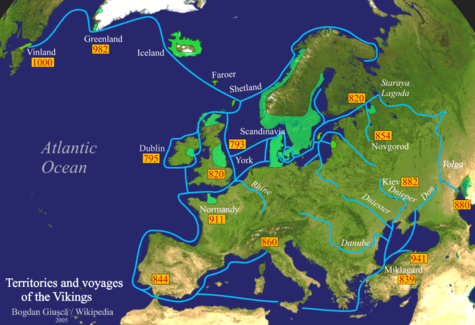
What we are looking at in the OP is further off the map, as noted by the red arrow of which i have applied below:
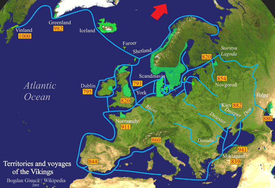
Vikings aren't known to have conclusively travelled further than that, but this 'brooch' seems to indicate otherwise. I'm not sure if it would completely revolutionise what we know of the vikings and their seafaring capabilities, but it would be an interesting topic to invest further research in. It just may lead to further (archaeological) studies regarding the reach of the vikings...
This object can be considered out of place in that the vikings were alleged to never have travelled that far...although i would say that it definitely could have been possible considering their seafaring capabilities.
Consider this map displaying the known expeditions of which the vikings had undertaken:

What we are looking at in the OP is further off the map, as noted by the red arrow of which i have applied below:

Vikings aren't known to have conclusively travelled further than that, but this 'brooch' seems to indicate otherwise. I'm not sure if it would completely revolutionise what we know of the vikings and their seafaring capabilities, but it would be an interesting topic to invest further research in. It just may lead to further (archaeological) studies regarding the reach of the vikings...
edit on 27-12-2014 by daaskapital because: sp
a reply to: daaskapital
I was under the impression that they had made it to Svalbard in the 1100's as well. Perhaps this date is inaccurate and they were there a couple of hundred years earlier.
I was under the impression that they had made it to Svalbard in the 1100's as well. Perhaps this date is inaccurate and they were there a couple of hundred years earlier.
edit on 27-12-2014 by AugustusMasonicus because: networkdude has no beer
a reply to: AugustusMasonicus
What about the required map projection maths, would not this mean they had a higher level of maths and knew that the earth was a globe?
-MM
What about the required map projection maths, would not this mean they had a higher level of maths and knew that the earth was a globe?
-MM
edit on 27-12-2014 by MerkabaMeditation because: (no reason given)
Is there another source other than this video?
Maybe one of the original dig the brooch was found?
Little handicapped here in that I don't speak Japanese, he lumped this in with ufo brooches???
I'm also all pro-Ooparts but this needs fleshed out a little more. My 2-cent's is these are Saami Brooches/maps traded/sold/taken by Vikings. Turns out the Saami Peoples were building ships long before the Vikings even got to Scandinavia.
saamiblog.blogspot.com...
originally posted by: Caver78
Is there another source other than this video?
Maybe one of the original dig the brooch was found?
Little handicapped here in that I don't speak Japanese, he lumped this in with ufo brooches???
I'm also all pro-Ooparts but this needs fleshed out a little more. My 2-cent's is these are Saami Brooches/maps traded/sold/taken by Vikings. Turns out the Saami Peoples were building ships long before the Vikings even got to Scandinavia.
saamiblog.blogspot.com...
I'm guessing it is this artifacts in the British Museum or a similar one:
British Museum brooch 1901,0718.1
Edit:
No, it can't be that one as it is flat underneath see more pictures of it here - unless it can be opened somehow.
-MM
edit on 27-12-2014 by MerkabaMeditation because: (no reason given)
edit on 27-12-2014 by MerkabaMeditation because: (no reason
given)
Something to consider in the mix
This timing would make for a habitable one but earlier exploration by sea would have been possible . They must have or could have thought the earth was warming up again and decided to make some new settlements . When the cold returned called the mini ice age they had to abandon that en devour .just my 2 cents a reply to: AugustusMasonicus
The Medieval Warm Period (MWP), Medieval Climate Optimum, or Medieval Climatic Anomaly was a time of warm climate in the North Atlantic region that may also have been related to other climate events around the world during that time, including China[1] and other areas, [2][3] lasting from about AD 950 to 1250.[4] It was followed by a cooler period in the North Atlantic termed the Little Ice Age.
originally posted by: MerkabaMeditation
a reply to: AugustusMasonicus
What about the required map projection maths, would not this mean they had a higher level of maths and knew that the earth was a globe?
-MM
Contrary to popular belief, many ancient societies postulated the theory of a spherical Earth. The theory was first floated in Ancient Greece, and other societies followed suit.
I'm not exactly sure what the vikings believed, but being a seafaring people, it is possible that they knew more than the average man on navigation and geography...
I am describing what's on this video for those who can't view. I have bolded the text from the video for easier viewing.
"Warning
All copyrights and ideas are
reserved soley by Hiroshi Hayashi,
Hamamats-city, Japan.
No one is allowed to use my ideas
in any case without my name
or permission.
Thank you very much."
The video, in the beginning is claiming UFO as the overt theme. Unfortunately, after 2 minutes, the author speaks in Japanese for what I assume is the rest of the videos.
@2:38, author asks (printed on screen): "Again I'd like to ask you what you think this is."
An image of what they might be insinuating is a brooch, but not the one pictured in the OP's image. At 2:54 a message on the screen appears: "Then I showed this photograph to abt. 20 Jr. high students and asked them what they thought this is". Continuing to show the same brooch.
At 3:00, still showing the same screen image, a second message appears on the bottom of the screen: "All of the students answered "UFO" without any hesitation, as soon as I had shown it."
At 4:50, the image the OP presented is now on the screen with this message: "And also I'd like to examine this brooch in the following video and please just keep it in your mind that this is a 3D brooch so precisely carved like a map of the North Pole on a disk mirror." Screen shows the image in two positions to support the 2nd image in thread of the 3d brooch. The next image on the screen is the 1st image in OP thread. Brooches usually attach to clothing or accessories and I can't see where this does. So I wouldn't call it a brooch or a button. At this point is isn't specified what size this object is.
The author continues with various messages, discussing the maps discrepancies and similarities on the brooch map and the present world map. And then he want's us to watch the next video 510 for further details. So far, I'm not intrigued. The next video comes on and it's another video of spacecrafts from aliens. That's where I also called it quits. It might have been better to go the UFO theme.
The Strickland brooch, also contains fixings for the missing pin to attach to clothing. From what I can tell, all brooches in the British Museum have an identifying title.
Since it took forever to write all this, I'm refraining from making a claim except, why didn't the British Museum notice it?
"Warning
All copyrights and ideas are
reserved soley by Hiroshi Hayashi,
Hamamats-city, Japan.
No one is allowed to use my ideas
in any case without my name
or permission.
Thank you very much."
The video, in the beginning is claiming UFO as the overt theme. Unfortunately, after 2 minutes, the author speaks in Japanese for what I assume is the rest of the videos.
@2:38, author asks (printed on screen): "Again I'd like to ask you what you think this is."
An image of what they might be insinuating is a brooch, but not the one pictured in the OP's image. At 2:54 a message on the screen appears: "Then I showed this photograph to abt. 20 Jr. high students and asked them what they thought this is". Continuing to show the same brooch.
At 3:00, still showing the same screen image, a second message appears on the bottom of the screen: "All of the students answered "UFO" without any hesitation, as soon as I had shown it."
At 4:50, the image the OP presented is now on the screen with this message: "And also I'd like to examine this brooch in the following video and please just keep it in your mind that this is a 3D brooch so precisely carved like a map of the North Pole on a disk mirror." Screen shows the image in two positions to support the 2nd image in thread of the 3d brooch. The next image on the screen is the 1st image in OP thread. Brooches usually attach to clothing or accessories and I can't see where this does. So I wouldn't call it a brooch or a button. At this point is isn't specified what size this object is.
The author continues with various messages, discussing the maps discrepancies and similarities on the brooch map and the present world map. And then he want's us to watch the next video 510 for further details. So far, I'm not intrigued. The next video comes on and it's another video of spacecrafts from aliens. That's where I also called it quits. It might have been better to go the UFO theme.
www.britishmuseum.org...
The Pitney Brooch Anglo-Scandinavian, 2nd half of the 11th century AD
Found in Pitney, Somerset, England. The brooch was cast in bronze with a slightly convex form, then gilded on both side. The reverse is plain, and still retains some fixings for the missing pin.
The Strickland brooch, also contains fixings for the missing pin to attach to clothing. From what I can tell, all brooches in the British Museum have an identifying title.
Since it took forever to write all this, I'm refraining from making a claim except, why didn't the British Museum notice it?
edit on 27-12-2014 by StoutBroux because: (no reason given)
a reply to: StoutBroux
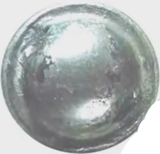
You are right, it is not a map on a brooch but on a shield in the Boston Museum of Fine Arts - he talks about the shield world map in another video that I found here:
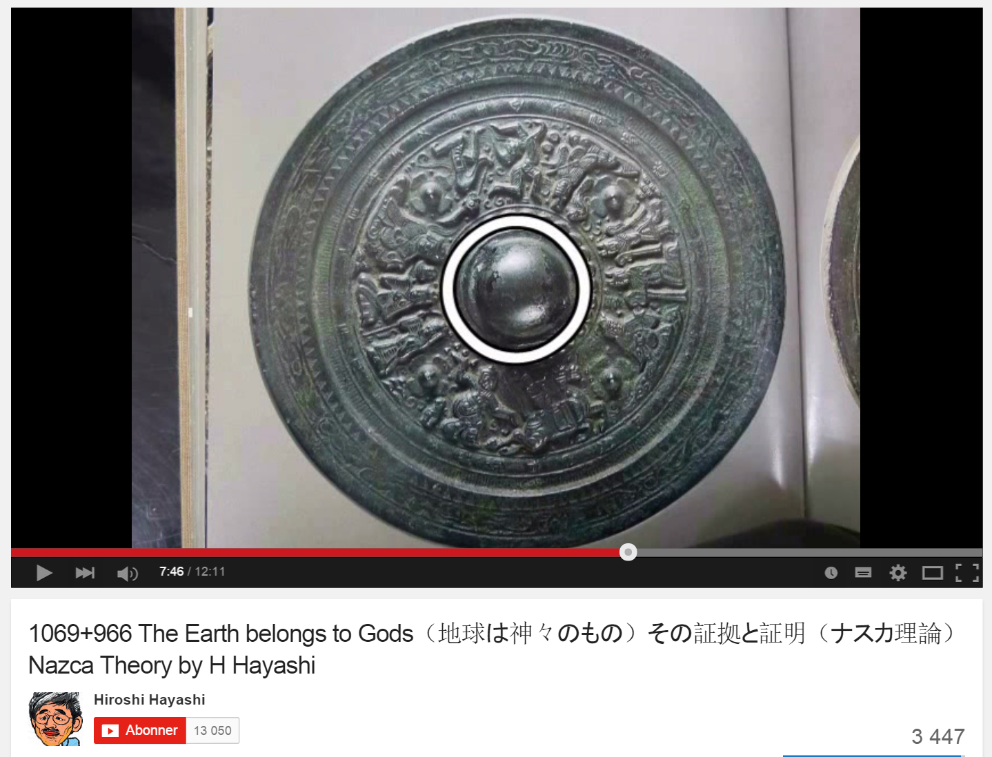 Screenshot of sheild with world map
I guess he just mixed the brooch with the world map in the first video, this shield is still very interesting though if someone that knows japaneese could find some information about it from the video.
Starts at about 4:50:
-MM
You are right, it is not a map on a brooch but on a shield in the Boston Museum of Fine Arts - he talks about the shield world map in another video that I found here:

I guess he just mixed the brooch with the world map in the first video, this shield is still very interesting though if someone that knows japaneese could find some information about it from the video.
Starts at about 4:50:
-MM
edit on 27-12-2014 by MerkabaMeditation because: (no reason given)
edit on 27-12-2014 by MerkabaMeditation because: (no reason
given)
The Vikings, along with other cultures in the world, did have maps and also did travel all over that ocean. It doesn't seem that we have found many
maps of the other ocean for some reason, maybe the Asians used those routes and we do not have access to them. After Columbus discovered America,
within twenty years they had accurate maps of the shores of America, not from new explorers but from pieced together maps of the Maritime shipping of
many countries. Seems that when the countries started cooperating, they found many maps of parts of the new world. I think it was England who pieced
these all together.
That is what I have read, and there is supposedly a lot of evidence out there but I do not have access to it. Ask the English, they claimed America from the Spanish using some of the Norwegian evidence, Norway was a colony of England at the time.
Columbus did not discover America, many knew of this continent. He just discovered how to take credit for the discovery. I don't know why they teach this in school yet here in America, I suppose that if they start training people to believe lies at a young age, it is easier to keep them believing in lies.
originally posted by: daaskapital
a reply to: MerkabaMeditation
This object can be considered out of place in that the vikings were alleged to never have travelled that far...although i would say that it definitely could have been possible considering their seafaring capabilities.
Vikings aren't known to have conclusively travelled further than that, but this 'brooch' seems to indicate otherwise. I'm not sure if it would completely revolutionise what we know of the vikings and their seafaring capabilities, but it would be an interesting topic to invest further research in. It just may lead to further (archaeological) studies regarding the reach of the vikings...
It's interesting alright. They did live in Greenland as called by Erik the Red in the warmer period, and recently evidence of them existing in Canada's Arctic, and sailed much of the North Atlantic, so maybe not so much a stretch of the imagination.
originally posted by: rickymouse
The Vikings, along with other cultures in the world, did have maps and also did travel all over that ocean. It doesn't seem that we have found many maps of the other ocean for some reason, maybe the Asians used those routes and we do not have access to them. After Columbus discovered America, within twenty years they had accurate maps of the shores of America, not from new explorers but from pieced together maps of the Maritime shipping of many countries. Seems that when the countries started cooperating, they found many maps of parts of the new world. I think it was England who pieced these all together.
That is what I have read, and there is supposedly a lot of evidence out there but I do not have access to it. Ask the English, they claimed America from the Spanish using some of the Norwegian evidence, Norway was a colony of England at the time.
Columbus did not discover America, many knew of this continent. He just discovered how to take credit for the discovery. I don't know why they teach this in school yet here in America, I suppose that if they start training people to believe lies at a young age, it is easier to keep them believing in lies.
That's about right, the Vikings were discovered to have resided in Newfoundland as well long before Columbus, and before that were only 'thought by some' to have discovered North America before the Newfoundland finds in the 1960's. The 1960's finds were quite dramatic then.
originally posted by: MerkabaMeditation
a reply to: StoutBroux
You are right, it is not a map on a brooch but on a shield in the Boston Museum of Fine Arts - he talks about the shield world map in another video that I found here:
Screenshot of sheild with world map
I guess he just mixed the brooch with the world map in the first video, this shield is still very interesting though if someone that knows japaneese could find some information about it from the video.
Starts at about 4:50:
-MM
Thanks! OK...so not a brooch.....
I think there's quite a lot in the circumpolar history we don't know yet but are just getting off our "high horses" and revisiting.
a reply to: rickymouse
When Columbus set foot on north america a native came up to him, and asked him if he had any beer, in English...
When Columbus set foot on north america a native came up to him, and asked him if he had any beer, in English...
Vikings always followed the coastline when they traveled. That way, they could learn landmarks and know safe places to go onshore when it was stormy.
They always traveled in groups as well. The whole of the East coast of Norway was populated in that way. The Sami people occupy the Northern inland
areas.
From what I learned from living in Norway is that in Summer, storms travel from continental Europe, across Scandinavia, and take three days to reach the UK. That way, they could easily travel with storms.
If there is one Viking super-map, then there should be also be smaller local maps.
From what I learned from living in Norway is that in Summer, storms travel from continental Europe, across Scandinavia, and take three days to reach the UK. That way, they could easily travel with storms.
If there is one Viking super-map, then there should be also be smaller local maps.
new topics
-
This should be plastered all over the airwaves
Mainstream News: 1 hours ago -
Oh, Good Gosh. “Kremlin Warns Stay Away from Greenland.”
World War Three: 2 hours ago -
Archbisop Vigano Warns of Deep State and Deep Church
New World Order: 3 hours ago -
A Flash of Beauty: Bigfoot Revealed ( documentary )
Cryptozoology: 8 hours ago -
Fire insurance in LA withdrawn months ago
General Conspiracies: 11 hours ago
top topics
-
Fire insurance in LA withdrawn months ago
General Conspiracies: 11 hours ago, 8 flags -
A Flash of Beauty: Bigfoot Revealed ( documentary )
Cryptozoology: 8 hours ago, 7 flags -
Oh, Good Gosh. “Kremlin Warns Stay Away from Greenland.”
World War Three: 2 hours ago, 6 flags -
This should be plastered all over the airwaves
Mainstream News: 1 hours ago, 4 flags -
Archbisop Vigano Warns of Deep State and Deep Church
New World Order: 3 hours ago, 3 flags
active topics
-
Trump says ownership of Greenland 'is an absolute necessity'
Other Current Events • 101 • : fringeofthefringe -
This should be plastered all over the airwaves
Mainstream News • 8 • : DAVID64 -
To become president, Zelensky had to learn Ukrainian
Political Conspiracies • 35 • : Oldcarpy2 -
Oh, Good Gosh. “Kremlin Warns Stay Away from Greenland.”
World War Three • 10 • : Imhere -
Los Angeles brush fires latest: 2 blazes threaten structures, prompt evacuations
Mainstream News • 302 • : KrustyKrab -
Fire insurance in LA withdrawn months ago
General Conspiracies • 26 • : sapien1982 -
The Truth about Migrant Crime in Britain.
Social Issues and Civil Unrest • 45 • : covent -
Judge rules president-elect Donald Trump must be sentenced in 'hush money' trial
US Political Madness • 87 • : tkwaz -
A Flash of Beauty: Bigfoot Revealed ( documentary )
Cryptozoology • 4 • : CosmicFocus -
Archbisop Vigano Warns of Deep State and Deep Church
New World Order • 0 • : FlyersFan
