It looks like you're using an Ad Blocker.
Please white-list or disable AboveTopSecret.com in your ad-blocking tool.
Thank you.
Some features of ATS will be disabled while you continue to use an ad-blocker.

The Mysterious Palpa/Nazca Lines Peru - LOST ANCIENT TECHNOLOGY?
page: 1share:
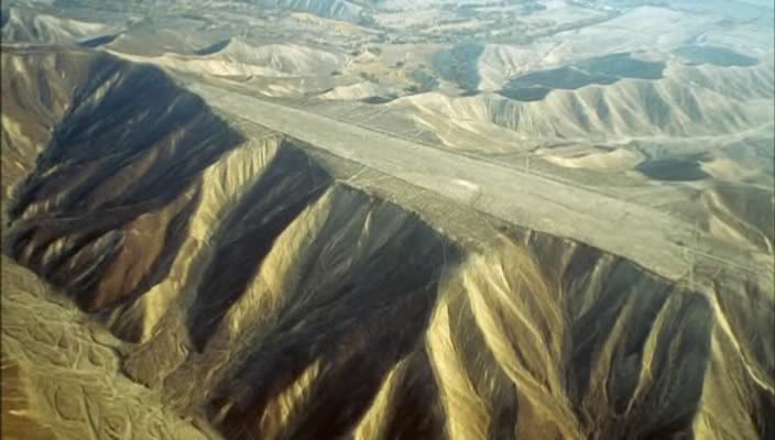
When The Nazca Lines are mentioned most people naturally think of the glyphs ie The Monkey or The Pelican or even ‘The Space Man’ but what I find
most perplexing are the lines! The way the lines are so perfectly straight regardless of the terrain is a sight to behold and bare in mind that the
longest one is a mind boggling 9 miles long and easily viewable from space! Personally I think these lines/markings were made from above to be seen
from above.
Here's some examples -
This one looks like the top of the mountain has been sheared off just incredible -
This one probably has had the top of the mountain sheared off –
Again –
How and why was this done? -
If man was acknowledged to have been able to fly when these lines were created then you’d be seen as a nutcase to suggest that they weren’t meant to be seen from above but because it isn't acknowledged the reverse is true! Mmm we are told to think in some very peculiar ways sometimes! To dismiss this enigma as ‘water markers’ or ‘sacred paths’ is foolishness of the highest order in my opinion. Also intriguingly in that area we find Elongated Skulls and of course the Megalithic Constructions which have had people scratching there heads in disbelief for donkeys years, now, is there a connection?
I think so how about you?
Here's some examples -
s3.postimg.org...
s10.postimg.org...
This one looks like the top of the mountain has been sheared off just incredible -
s27.postimg.org...
s29.postimg.org...
s12.postimg.org...
This one probably has had the top of the mountain sheared off –
s29.postimg.org...
Again –
s30.postimg.org...
How and why was this done? -
s30.postimg.org...
If man was acknowledged to have been able to fly when these lines were created then you’d be seen as a nutcase to suggest that they weren’t meant to be seen from above but because it isn't acknowledged the reverse is true! Mmm we are told to think in some very peculiar ways sometimes! To dismiss this enigma as ‘water markers’ or ‘sacred paths’ is foolishness of the highest order in my opinion. Also intriguingly in that area we find Elongated Skulls and of course the Megalithic Constructions which have had people scratching there heads in disbelief for donkeys years, now, is there a connection?
I think so how about you?
edit on 8-8-2014 by JamesTB because: to fix a link
When I read about the lines in Nazca I always think about this.
I'm paraphrasing so it might not be too accurate:
During WW2 a country used a small island as a temporary landing strip. A local indigenous tribe was present at the location and they were given knives, pots, food, soda and supplies by the troops that were using their land. The war ended and the air force left the site. The tribe noticing they left started building replicas of the aircraft out of straw and wood on the runways to signal their long lost friends(air force) to come back and give them more modern items, as before.
I've heard many of the other theories about these lines, but this one seems to make the most sense to me.
There are more 'Runways' than actual glyphs there, thousands of them some are huge and others rather small in comparison.
It is truly a mystery to me these long lines, I've read theories of water irrigation to space ship runways, neither of which in my mind is an explanation.
This is my favourite one
It is truly a mystery to me these long lines, I've read theories of water irrigation to space ship runways, neither of which in my mind is an explanation.
This is my favourite one
originally posted by: Sparta
There are more 'Runways' than actual glyphs there, thousands of them some are huge and others rather small in comparison.
It is truly a mystery to me these long lines, I've read theories of water irrigation to space ship runways, neither of which in my mind is an explanation.
This is my favourite one
For me, that is the most fascinating picture. Taking into account that erosion has take away land from the top of that mountain, there would have been grassy bits to either side. It really does look like a runway or perhaps a racing track.
originally posted by: zardust
a reply to: JamesTB
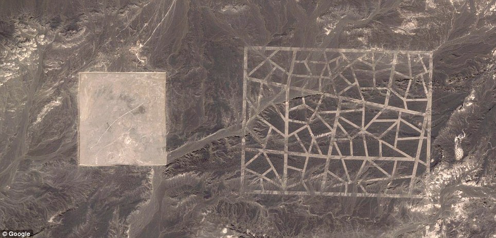
Thats some crazy stuff. I've never seen those 'runways' before. Beautiful geometric patterns in those lines also.
Agreed check these out too, perfect circles with a grid pattern in the center -
s27.postimg.org...
a reply to: JamesTB
wow! That's fascinating! Where is this at specifically? Is it possible to see this on Google Earth? I wouldn't mind that being my CPU Background, but i'd need something crisper.
edit: The very last picture you posted is what i'm asking about. The geometric shapes
wow! That's fascinating! Where is this at specifically? Is it possible to see this on Google Earth? I wouldn't mind that being my CPU Background, but i'd need something crisper.
edit: The very last picture you posted is what i'm asking about. The geometric shapes
edit on Friu2014-08-08T11:00:29-05:00kf2014Fri, 08
Aug 2014 11:00:29 -05002014-08-08T11:00:29-05:002014v by DuckforcoveR because: clarification
originally posted by: DuckforcoveR
a reply to: JamesTB
wow! That's fascinating! Where is this at specifically? Is it possible to see this on Google Earth? I wouldn't mind that being my CPU Background, but i'd need something crisper.
edit: The very last picture you posted is what i'm asking about. The geometric shapes
Google Nazca lines, Nazca province, Ica, Peru.
originally posted by: DuckforcoveR
a reply to: JamesTB
wow! That's fascinating! Where is this at specifically? Is it possible to see this on Google Earth? I wouldn't mind that being my CPU Background, but i'd need something crisper.
edit: The very last picture you posted is what i'm asking about. The geometric shapes
Not sure about Google Earth but might be worth a look. Here's a couple more photos of it -
s17.postimg.org...
s4.postimg.org...
How? Easy the plains and hills there are covered with small dark stones, these are moved and the lighter soil shows thru.
Why is a bit more complicated as the Nazca people left no writings. As noted earlier they were probably religious in nature, they can be seen from the hills around the plains and some on hills can be seen from the plains.
Making them probably was thought to bring merit to the builder or perhaps they thought it evoked magical powers in their behave.
Here is a study of one aspect of the ancient Nazca people's religious beliefs
Study of Nazca head hunting
James how is shifting rocks to leave a pattern in the soil "Lost ancient technology"?
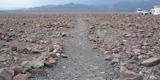
On the ground, most of the lines are formed by a shallow trench with a depth of between 10 cm (3.9 in) and 15 cm (5.9 in). Such trenches were made by removing the reddish-brown iron oxide-coated pebbles that cover the surface of the Nazca desert. When this gravel is removed the light-colored clay earth which is exposed in the bottom of the trench produces lines which contrast sharply in color and tone with the surrounding land surface. This sublayer contains high amounts of lime which, with the morning mist, hardens to form a protective layer that shields the lines from winds, thereby preventing erosion.
Why is a bit more complicated as the Nazca people left no writings. As noted earlier they were probably religious in nature, they can be seen from the hills around the plains and some on hills can be seen from the plains.
Making them probably was thought to bring merit to the builder or perhaps they thought it evoked magical powers in their behave.
Here is a study of one aspect of the ancient Nazca people's religious beliefs
Study of Nazca head hunting
James how is shifting rocks to leave a pattern in the soil "Lost ancient technology"?
edit on 8/8/14 by Hanslune because: (no reason
given)
edit on 8/8/14 by Hanslune because: (no reason given)
originally posted by: parad0x122
a reply to: Hanslune
I believe James is referring to what the lines could be used for, not the lines themselves.
Yes and what does 'lost ancient technology' have to do with the lines? Certainly not in making them so what purpose are they that supports their being "lAT"? One wonders.
They don't orientate to any particular point, some are tiny some huge (one line goes 20+ kilometers), we see so many now because of the natural dryness of this region other places where this was done have been eroded away or over grown. Some point to water sources some to the rising/setting sun and perhaps other astronomical events but the majority do not.
Marking the terrain is a fairly common human cultural trait we still do it today.
edit on 8/8/14 by Hanslune because: (no reason
given)
originally posted by: parad0x122
a reply to: Hanslune
I think that's what the thread is trying to hypothesize about:
Why would an ancient civilization need marking that, arguably, would only be useful from the sky looking down?
Which can also be seen from the hills surround said plains. Those on hills can be seen from the plains or other hills.
Indeed lets see if we get anything that is new as this topic is rather common and often talked about.
originally posted by: parad0x122
I believe James is referring to what the lines could be used for, not the lines themselves.
Flying saucers? What kind of flying saucers would have to rely on lines drawn on the ground to do anything? They can fly but they don't have maps or compasses or maybe even some kind of GPS system in place?
If we're going to imagine some kind of advanced technology, why not imagine all of it, and not just the parts that make the "explanation" work?
originally posted by: Hanslune
Indeed lets see if we get anything that is new as this topic is rather common and often talked about.
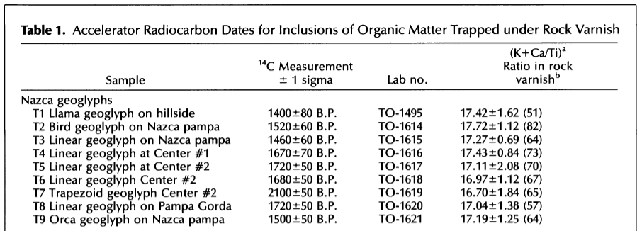
Has anybody been able to date the markings to show which ones were the first done, perhaps abandoned, and then which ones were done later? It might be interesting to see how they went from simple to more sophisticated or vice versa, and which patterns they got tired of in favor of newer ones.
The "spaceman," for instance (the one with the huge penis that has been rubbed out), seems like a much later addition to me.
a reply to: Blue Shift
Our satellites can still use things etched into the ground to calibrate themselves when they are having communication issues, for starters. Like these, for instance:
Gobi Desert Mystery Explained
And who said anything about flying saucers, anyway?
Our satellites can still use things etched into the ground to calibrate themselves when they are having communication issues, for starters. Like these, for instance:
Gobi Desert Mystery Explained
And who said anything about flying saucers, anyway?
edit on 8-8-2014 by parad0x122 because: (no reason given)
originally posted by: Blue Shift
originally posted by: Hanslune
Indeed lets see if we get anything that is new as this topic is rather common and often talked about.
Has anybody been able to date the markings to show which ones were the first done, perhaps abandoned, and then which ones were done later? It might be interesting to see how they went from simple to more sophisticated or vice versa, and which patterns they got tired of in favor of newer ones.
The "spaceman," for instance (the one with the huge penis that has been rubbed out), seems like a much later addition to me.
Yes but I don't believe the method used is very accurate - too many variables.
Dating the Nazca lines
a reply to: JamesTB
Here's another theory:
If the above is true:
Why build them shaped as animals and not simply straight lines?
And why are some oriented towards the sunset during the winter solstice?
Here's another theory:
A paper published Monday in Proceedings of the National Academy of Sciences explains the existence of dozens of geoglyphs—essentially rock and earthen formations—in Peru’s Chincha Valley that predate the existence of the Nazca civilization, and were likely used as pointing devices to help people find towns and ancient markets.
motherboard.vice.com...
If the above is true:
Why build them shaped as animals and not simply straight lines?
And why are some oriented towards the sunset during the winter solstice?
new topics
-
There Must Be Something to Hide!
Political Conspiracies: 53 minutes ago -
Your Opinion ... 2nd assassination attempt ... the shooter was a ... ????
Political Conspiracies: 4 hours ago -
tweeting nasty words worse than child porn according to judges and the Labour party
Mainstream News: 6 hours ago -
The Why Files does Alien Implants
Aliens and UFOs: 8 hours ago -
Democrats Oversee Big Surge In Cop Murder
Social Issues and Civil Unrest: 8 hours ago -
The "Hundredth Monkey" Effect and the Modern Western "Agenda"
New World Order: 9 hours ago -
Sen. Johnson Asks the CDC How Many Americans Were Killed by COVID Shots
Science & Technology: 11 hours ago
top topics
-
Sen. Johnson Asks the CDC How Many Americans Were Killed by COVID Shots
Science & Technology: 11 hours ago, 26 flags -
tweeting nasty words worse than child porn according to judges and the Labour party
Mainstream News: 6 hours ago, 16 flags -
Democrats Oversee Big Surge In Cop Murder
Social Issues and Civil Unrest: 8 hours ago, 14 flags -
Your Opinion ... 2nd assassination attempt ... the shooter was a ... ????
Political Conspiracies: 4 hours ago, 10 flags -
Gender identity
Rant: 17 hours ago, 10 flags -
The Why Files does Alien Implants
Aliens and UFOs: 8 hours ago, 8 flags -
I just looked around and he's gone
Music: 14 hours ago, 7 flags -
There Must Be Something to Hide!
Political Conspiracies: 53 minutes ago, 7 flags -
The "Hundredth Monkey" Effect and the Modern Western "Agenda"
New World Order: 9 hours ago, 6 flags -
1 and 2 Kings
Religion, Faith, And Theology: 17 hours ago, 0 flags
active topics
-
Your Opinion ... 2nd assassination attempt ... the shooter was a ... ????
Political Conspiracies • 60 • : FlyersFan -
Another attempt on Trump?
2024 Elections • 378 • : wAnchorofCarp -
Trump is the planet's leading defender of domestic animals
Mainstream News • 90 • : andy06shake -
-@TH3WH17ERABB17- -Q- ---TIME TO SHOW THE WORLD--- -Part- --44--
Dissecting Disinformation • 2614 • : watchitburn -
The Reactionary Conspiracy 13. The plot’s theology.
General Conspiracies • 225 • : MarxistDebunker2 -
There Must Be Something to Hide!
Political Conspiracies • 7 • : BeyondKnowledge3 -
Kamala Harris helped shut down Backpage.com. Sex workers are still feeling the fallout
US Political Madness • 9 • : StudioNada -
Sen. Johnson Asks the CDC How Many Americans Were Killed by COVID Shots
Science & Technology • 36 • : tarantulabite1 -
Gender identity
Rant • 18 • : Irishhaf -
Jane's Addiction - Perry Farrell gets aggresive with Dave Navarro
Music • 13 • : gortex