It looks like you're using an Ad Blocker.
Please white-list or disable AboveTopSecret.com in your ad-blocking tool.
Thank you.
Some features of ATS will be disabled while you continue to use an ad-blocker.
share:
Tornado Warning
SEVERE WEATHER STATEMENT
NATIONAL WEATHER SERVICE LITTLE ROCK AR
928 PM CDT SUN APR 27 2014
ARC063-067-280245-
/O.CON.KLZK.TO.W.0015.000000T0000Z-140428T0245Z/
INDEPENDENCE AR-JACKSON AR-
928 PM CDT SUN APR 27 2014
...TORNADO EMERGENCY FOR SWIFTON...
...A TORNADO WARNING REMAINS IN EFFECT FOR NORTHEASTERN JACKSON AND
EAST CENTRAL INDEPENDENCE COUNTIES UNTIL 945 PM CDT...
AT 926 PM CDT...STORM SPOTTERS AND NATIONAL WEATHER SERVICE
METEOROLOGISTS WERE TRACKING A CONFIRMED TORNADO WITH REPORTS OF
DAMAGE. THIS POTENTIALLY DEADLY TORNADO WAS LOCATED 3 MILES
NORTHWEST OF TUCKERMAN...OR 9 MILES NORTH OF NEWPORT...MOVING
NORTHEAST AT 40 MPH.
THIS IS A TORNADO EMERGENCY FOR SWIFTON. TAKE COVER NOW.
* LOCATIONS IN OR NEAR THE PATH OF THIS TORNADO INCLUDE...
TUCKERMAN... SWIFTON... KENYON...
ELGIN...
PRECAUTIONARY/PREPAREDNESS ACTIONS...
TO REPEAT...A DAMAGING TORNADO IS ON THE GROUND. THIS IS AN
EXCEPTIONALLY DANGEROUS SITUATION. THIS STORM IS PRODUCING A LIFE
THREATENING...CONFIRMED TORNADO CAPABLE OF SIGNIFICANT DESTRUCTION.
TAKE COVER IMMEDIATELY.
&&
A TORNADO WATCH REMAINS IN EFFECT UNTIL 200 AM CDT MONDAY MORNING FOR
NORTHEASTERN ARKANSAS.
LAT...LON 3575 9103 3565 9133 3577 9140 3589 9124
3589 9103 3588 9102
TIME...MOT...LOC 0228Z 234DEG 36KT 3577 9123
$$
44
9:49p CT: New rotations/possible tornadoes near Batesville, AR *behind* original long-track supercell now in NE Ark.
Reported
Police: At least 6 people confirmed dead; many homes flattened in Vilonia & Mayflower, Ark.
They are expecting these storms to last through Thursday.
Police: At least 6 people confirmed dead; many homes flattened in Vilonia & Mayflower, Ark.
They are expecting these storms to last through Thursday.
edit on 27-4-2014 by MrLimpet because: (no reason given)
Sunday Night, April 27-28
Severe thunderstorms in the following areas:
Southeast South Dakota
Eastern Nebraska
Iowa (except extreme northeast)
Northwest, central, and southern Illinois
West-central and southern Indiana
West half of Kentucky - TOR:CON 5
West half of Tennessee - TOR:CON 5
Northwest and west-central Alabama
Mississippi - TOR:CON 7 north and central
Louisiana - TOR:CON 7 northeast
East Texas - TOR:CON 5
Extreme eastern Oklahoma
Extreme eastern Kansas
Missouri
Arkansas - TOR:CON 7 southeast, 5 northeast
Monday, April 28
Severe thunderstorm and tornado outbreak in the following areas (alphabetical by state):
North Alabama - TOR:CON 6
West Alabama
Southern and eastern Arkansas - TOR:CON 5
North Georgia
Illinois
Northwest, central and south Indiana
Iowa - TOR:CON 5
Kentucky
Louisiana - TOR:CON 7 northeast
East half of Missouri
Mississippi - TOR:CON 7
Extreme northeast Nebraska
Western and south-central North Carolina
North half of South Carolina
Tennessee - TOR:CON 5
Upper coastal Texas (near Beaumont)
The severe threat is likely to continue overnight and transition to a heavy rain threat overnight in parts of Louisiana, Mississippi, north Alabama, middle and east Tennessee, and central and eastern Kentucky.
edit on 27-4-2014 by Havox because: (no reason given)
a reply to: Havox
What direction from Beaumont tomorrow. Depending on direction I may be in the line of fire.
Just checked NOAA and not seeing anything in the forecasts. I have to go to bed now- I get up very early for work. Won't be able to check in until tomorrow night. All stay safe.
What direction from Beaumont tomorrow. Depending on direction I may be in the line of fire.
Just checked NOAA and not seeing anything in the forecasts. I have to go to bed now- I get up very early for work. Won't be able to check in until tomorrow night. All stay safe.
edit on 4/27/2014 by TXTriker because: extra stuff
a reply to: TXTriker
here you go good discussion
AREA FORECAST DISCUSSION
NATIONAL WEATHER SERVICE LAKE CHARLES LA
943 PM CDT SUN APR 27 2014
.DISCUSSION...
UPDATED THE AREAL DISTRIBUTION OF POPS TO MORE CLOSELY FOLLOW THE
HRR (HIGH RESOLUTION RAPID REFRESH) SOLUTION. OTHERWISE...THE
ZONE PACKAGE IS ON TARGET.
JT
&&
.PREV DISCUSSION... /ISSUED 630 PM CDT SUN APR 27 2014/
DISCUSSION...
FOR 00Z TAFS...VFR TO MVFR CONDITIONS EXPECTED THIS EVENING...WITH
GUSTY SOUTH WINDS. NOT EXPECTING THE NEXT ROUND OF PRECIP UNTIL
TOWARDS DAYBREAK...BUT LOW CONFIDENCE ON COVERAGE AT THIS POINT.
PREV DISCUSSION... /ISSUED 436 PM CDT SUN APR 27 2014/
DISCUSSION...
LATEST WATER VAPOR SATELLITE IMAGERY SHOWED A VIGOROUS UPPER LOW
OVER NW KS/SW NE...WITH A VIGOROUS PACIFIC JET NOSING IN FROM THE
PAC NW AND CURLING CYCLONICALLY THROUGH THE BASE OF THE LOW. A
SUBTROPICAL JET WAS NOTED TO THE SOUTH ACROSS CENTRAL MX INTO THE
WRN GULF. KLCH AND KPOE VWPS CONTINUE TO SHOW A 50KT PLUS
SOUTHWESTERLY LLJ.
AT THE SFC...LOW PRESSURE IS HARD TO MISS OVER NW KS...WITH A
TRAILING CDFNT/DRYLINE THROUGH CENTRAL OK/TX.
HARD TO HAVE A GREAT DEAL OF FAITH IN ANY SPECIFIC SHORT TERM
GUIDANCE...AS PRECIOUS FEW CAUGHT THE ISOLATED TO SCATTERED
ELEVATED CONVECTION THAT DEVELOPED THIS AFTERNOON. THE ONLINE SPC
4KM WRF WASNT TOO BAD...AND THE HRRR DID FINALLY CATCH ON. THESE
TWO MODELS...WITH SOME ADDITIONAL SUPPORT FROM GLOBAL
MODELS...DEPICT A BAND OF CONVECTION INITIATING AFTER MIDNIGHT IN
THE VICINITY OF EAST CENTRAL TEXAS NE TWD SHREVEPORT. THE
SOUTHWESTWARD EXTENT OF ANY SUCH DEVELOPMENT IS A BIT
UNCERTAIN...BUT IT IS NOT OUT OF THE QUESTION FOR NORTHERN ZONES
TO BE AFFECTED GIVEN THE THE PROJECTED EAST/NORTHEAST MOVEMENT.
WILL MAINTAIN HIGHEST POPS TONIGHT IN THIS AREA...AND HOLD ONTO
THE SEVERE WORDING.
GENERALLY PRESERVED THE INHERITED INLAND WIND HAZARDS...BUT DID
TWEAK THE MARINE HAZARDS A BIT...EASING OUT OF THE SCA FOR THE
COASTAL LAKES AND BAYS MID EVENING...AND THE INLAND WATERS WEST OF
CAMERON AFTER MIDNIGHT CONCURRENT WITH LATEST PROGS THAT SHOW
WINDS STARTING TO DECREASE FROM WEST TO EAST OVERNIGHT AND INTO
TOMORROW. A WIND ADVISORY MAY STILL BE WARRANTED FOR A TIME ACROSS
SOUTH/EAST CENTRAL LOUISIANA...BUT WILL LET THE OVERNIGHT CREW
MAKE THE CALL ON THAT AS IT LOOKS A LITTLE MORE MARGINAL.
CONVECTIVE PROSPECTS WILL ALSO SHIFT EAST TOMORROW...AS THE
CDFNT PUSHES JUST EAST OF A KSHV TO KLFK LINE BY TOMORROW
AFTERNOON. HAVE GENERALLY LEFT THIS PART OF THE FORECAST AS
IS...STAYING MAINLY WITH LOW TO MID RANGE POPS AND PRESERVING THE
SEVERE WORDING PER SPC DAY 2 CONVECTIVE OUTLOOK.
THE FRONT IS STILL FCST TO PUSH THROUGH THE DURING THE AFTERNOON
AND EVENING HOURS ON TUE...WITH THE SEVERE RISK DISPLACED TO OUR
EAST BY THIS TIME. ALTHOUGH STILL NOT IN IDEAL AGREEMENT...THE GFS
HAS COME A LONG WAY TOWARD THE ECMWF SOLUTION IN DEPICTING
SOUTHWESTERLY FLOW ALOFT...WITH ONE OR MORE FRONTAL WAVES/LOWS
DEVELOPING ALONG THE FRONT. APPEARS THAT THE BEST CHANCE OF ANY
RAIN AFFECTING THE AREA WOULD BE THU NIGHT-FRI...AS BOTH MODELS
DEPICTING A SHORTWAVE TROF PIVOTING THROUGH THE NW GULF COAST
REGION.
MARINE...
GUSTY SOUTH WINDS AND ROUGH SEAS WILL CONTINUE THIS EVENING AS A
LOW PRESSURE SYSTEM DEVELOPS IN THE PLAINS. WINDS WILL BEGIN TO
DIMINISH A BIT OVER THE COASTAL LAKES AND BAYS TONIGHT AND THE
WATERS WEST OF CAMERON LATE TONIGHT INTO TOMORROW. TIDES WILL BE
RUNNING ABOUT ONE FOOT ABOVE NORMAL TODAY AND MONDAY. THE CHANCE
OF SHOWERS AND THUNDERSTORMS WILL ALSO CONTINUE INTO EARLY NEXT
WEEK AS THIS LOW PRESSURE SYSTEM SLOWLY MOVES EAST THROUGH THE
CENTRAL UNTIED STATES...CULMINATING IN A FRONT CROSSING THE REGION
TUESDAY NIGHT. OFFSHORE FLOW WILL PREVAIL IN THE WAKE OF THE FRONT
FOR THE REST OF THE WORK WEEK.
After a little rumbling of thunder, the storm seems to have passed us. Weather radio has sounded twice now with the same Tornado Watch that runs
until 2 AM and covers eastern Missouri, western Kentucky & Tennessee and south Illinois.
From looking at the radar it appears that if the storm follows it current course, we'll only get a slight brush from the tail end of it, if anything. That's a relief with a generator that isn't working and two freezers of food.
Edit to add: I too am entranced by storms. My father and I used to sit on the porch and watch them roll in, dazzled by the majesty. I remember well that we were sitting watching one coming in when we heard the roar. Daddy got up, told me to get the cat, he called the dog and Mama and we all went to the basement. It passed about a mile from our house sheering off the tops of trees and taking the roof off a barn.
edit on 27-4-2014 by
diggindirt because: (no reason given)
Western Kentucky here..... south of Owensboro. First line won't hit me for another 60-90 minutes... hope everything goes ok. We are TorCon
5.
edit on R482014-04-27T23:48:58-05:00k484Vpm by RickinVa because: (no reason given)
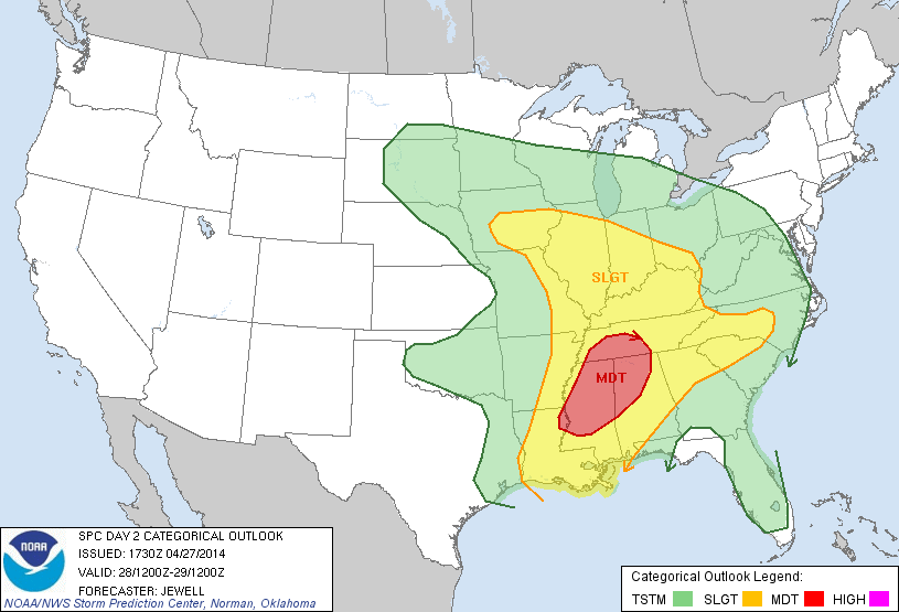
Convective Outlook for April 28th (Categorical) issued 4/27
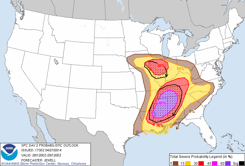
Convective Outlook for April 28th (Probabilistic) issued 4/27 www.spc.noaa.gov...
Discussion:

Convective Outlook for April 28th (Probabilistic) issued 4/27

Discussion:
www.spc.noaa.gov...
...THERE IS A MDT RISK OF SVR TSTMS ACROSS MUCH OF MS...NRN AL...TN...NERN LA...
...THERE IS A SLGT RISK OF SVR TSTMS FROM IA AND IL SWD ACROSS THE OH...TN...THE MID/LOWER MS VALLEY EWD TO THE WRN CAROLINAS...
...SUMMARY...
WIDESPREAD SEVERE STORMS INCLUDING STRONG TORNADOES...DAMAGING WINDS AND VERY LARGE HAIL APPEAR LIKELY MONDAY AND MONDAY NIGHT ACROSS MUCH OF MISSISSIPPI...NORTHERN ALABAMA...TENNESSEE...SOUTHERN KENTUCKY...AND NORTHEASTERN LOUISIANA.
...SYNOPSIS...
LOW-PRESSURE WILL BECOME VERTICALLY STACKED OVER ERN NEB AND IA DURING THE DAY WITH LEADING JET MAX DEVELOPING NEWD FROM THE ARKLATEX INTO THE LOWER OH VALLEY. AN OCCLUDED FRONT WILL EXTEND EWD FROM THE LOW ACROSS IA AND NRN IL...WITH WARM FRONT LIFTING NWD ACROSS INDIANA AND OHIO. A COLD FRONT WILL EXTEND SWD FROM THE LOW...ARCING RAPIDLY NEWD ACROSS THE MID MO RIVER VALLEY DURING THE DAY AND BECOMING STATIONARY ACROSS THE LOWER MS RIVER VALLEY BY LATE AFTERNOON. AN UNSTABLE AND MOIST ENVIRONMENT WILL EXIST AHEAD OF THE COLD FRONT WITH SHEAR PROFILES FAVORABLE FOR SEVERE THUNDERSTORMS ACROSS A LARGE AREA FROM IA TO THE CNTRL GULF COAST.
TO THE E...A FRONT WILL GRADUALLY RETREAT NWD ACROSS NC...ALLOWING FOR DESTABILIZATION AND A THREAT OF ISOLATED SEVERE STORMS THERE.
...LOWER MS VALLEY EWD INTO NRN AL AND MIDDLE TN...
WHILE THE PREVIOUS DAYS CONVECTION WILL LIKELY PLAY A ROLE IN DELINEATING THE PRECISE THREAT CORRIDOR...A SW-NE ORIENTED ZONE OF TRAINING SEVERE THUNDERSTORMS IS LIKELY FROM NERN LA ACROSS MS AND INTO NRN AL AND MIDDLE TN. THE STORMS WILL EITHER BE TIED TO THE COLD FRONT...OR AN OUTFLOW BOUNDARY WHICH COULD SPREAD OUT AHEAD OF THE MAIN SLOW MOVING FRONT. REGARDLESS...A VERY MOIST AND UNSTABLE AIR MASS WILL RESIDE AHEAD OF THE COLD FRONT...WITH SHEAR PROFILES QUITE FAVORABLE FOR SUPERCELLS AND TORNADOES. A LONG UPDRAFT RESIDENCE TIME IN THE UNSTABLE AND HIGHLY SHEARED ENVIRONMENT...AS WELL AS RELATIVELY STEEP MIDLEVEL LAPSE RATES SUGGEST STRONG TORNADOES WILL BE POSSIBLE. VERY LARGE HAIL WILL ALSO OCCUR AS WELL AS POTENTIAL FLOODING. THE MOST SIGNIFICANT TORNADO THREAT IS EXPECTED ACROSS MS.
...CNTRL AND NRN IL...FAR ERN IA AND NWRN IND...
STRONG HEIGHT FALLS AND COOLING ALOFT WITH THE LEFT-EXIT REGION OF THE MIDLEVEL JET WILL OVERSPREAD THE WARM SECTOR...RESULTING IN RAPID DESTABILIZATION. WITH LITTLE CAPPING...A BROKEN ARC OF STORMS IS EXPECTED TO FORM BY EARLY AFTERNOON ALONG THE COLD FRONT. LARGE HAIL WILL BE LIKELY ALONG WITH A FEW TORNADOES.
...NRN SC INTO WRN AND CNTRL NC...
AN E-W ORIENTED BOUNDARY WILL GRADUALLY MOVE NWD ACROSS NC...WITH MID 60S DEWPOINTS TO THE S. DAYTIME HEATING WILL ALLOW FOR DESTABILIZATION WITH AROUND 1000-1500 MLCAPE DEVELOPING BY AFTERNOON. WHILE SHORTWAVE RIDGING WILL EXIST MUCH OF THE DAY...COOLING ALOFT AND INCREASING SHEAR PROFILES WILL SPREAD INTO FAR WRN NC AND SC LATE IN THE DAY...RESULTING IN A FAVORABLE SUPERCELL ENVIRONMENT. HAIL WILL BE A DISTINCT THREAT WITH THE STRONGER CORES...BUT A TORNADO OR TWO WILL BE POSSIBLE AS LOW-LEVEL SHEAR INCREASES LATE IN THE DAY.
^*~ The links provided in my previous post, link to the 'Day 2' Convective Outlook. Now 4/29. ~*^
----- The 'Day 1' Convective Outlook for today; (4/28) has been linked below -----
www.spc.noaa.gov...
Forecast discussion and maps shown above, are still relevant to today; which is now 'Day 1'.
----- The 'Day 1' Convective Outlook for today; (4/28) has been linked below -----
www.spc.noaa.gov...
Forecast discussion and maps shown above, are still relevant to today; which is now 'Day 1'.
Hey guys, first round of storms in my area now. TONS of rain, and probably the most frequent Cloud to ground lightning I've ever seen, but no tornado
warnings on it.
Looks like it's just scattered thunderstorms for me until this afternoon when more severe storms are expected. Stay safe everyone, will try to give
updates throughout the day.
Just checking in from middle mo.
Thank you for the thread, now outside to pick up the stuff that blew about.
A bit scary last night, tornadoes and high wind had me in Mother hen mode for all of my pets and children.
This is going to be a bad year with this kind of weather, it is not over yet, we keep stalling into pre spring weather verses the end of winter. Very unusual and not over yet.
new topics
-
Tariffs all around, Except for ...
Predictions & Prophecies: 20 minutes ago -
Gen Flynn's Sister and her cohort blow the whistle on DHS/CBP involvement in child trafficking.
Whistle Blowers and Leaked Documents: 4 hours ago -
Anybody else using Pomodoro time management technique?
General Chit Chat: 7 hours ago -
Bucks County commissioners vote to count illegal ballots in Pennsylvania recount
2024 Elections: 9 hours ago -
Trump sues media outlets -- 10 Billion Dollar lawsuit
US Political Madness: 10 hours ago -
Fired fema employee speaks.
US Political Madness: 11 hours ago
top topics
-
Trump sues media outlets -- 10 Billion Dollar lawsuit
US Political Madness: 10 hours ago, 24 flags -
Bucks County commissioners vote to count illegal ballots in Pennsylvania recount
2024 Elections: 9 hours ago, 21 flags -
How long till it starts
US Political Madness: 12 hours ago, 17 flags -
USSS Agent Fired for Having Sex In Michelle Obama's Bathroom
Politicians & People: 14 hours ago, 10 flags -
Watching TV
Jokes, Puns, & Pranks: 16 hours ago, 9 flags -
Fired fema employee speaks.
US Political Madness: 11 hours ago, 9 flags -
Gen Flynn's Sister and her cohort blow the whistle on DHS/CBP involvement in child trafficking.
Whistle Blowers and Leaked Documents: 4 hours ago, 7 flags -
Anybody else using Pomodoro time management technique?
General Chit Chat: 7 hours ago, 3 flags -
Tariffs all around, Except for ...
Predictions & Prophecies: 20 minutes ago, 0 flags
active topics
-
Bucks County commissioners vote to count illegal ballots in Pennsylvania recount
2024 Elections • 19 • : theatreboy -
Tariffs all around, Except for ...
Predictions & Prophecies • 0 • : FullHeathen -
How long till it starts
US Political Madness • 17 • : WeMustCare -
USSS Agent Fired for Having Sex In Michelle Obama's Bathroom
Politicians & People • 24 • : rickymouse -
The Acronym Game .. Pt.4
General Chit Chat • 962 • : FullHeathen -
TRUMP Could Be Our Modern Day MOSES - The Similarities are Striking.
ATS Skunk Works • 246 • : WeMustCare -
Anybody else using Pomodoro time management technique?
General Chit Chat • 7 • : tamusan -
The Trump effect 6 days after 2024 election
2024 Elections • 141 • : cherokeetroy -
Thanksgiving 2024
Member Art • 19 • : rickymouse -
President-Elect Donald Trump will Meet with Coup-Victim JOE BIDEN on Wed 11.13.2024.
2024 Elections • 35 • : WeMustCare
