It looks like you're using an Ad Blocker.
Please white-list or disable AboveTopSecret.com in your ad-blocking tool.
Thank you.
Some features of ATS will be disabled while you continue to use an ad-blocker.
share:
I read in one of the articles from the OP that the rescue workers were trying everything they could to help get to the people in the mudslide, that
they had even tried hover boards to slide across the quicksand type mud. As Westcoast stated from her connections these rescuers are in great need of
mental health/ spiritual guidance after something this unique and tragic where all the training in the world could not save lives close enough to
simply listen to the vulnerable cries for help.
This is going to be unimaginable for the recovery teams. My prayers remain strong for this tragic unfolding event.
This is going to be unimaginable for the recovery teams. My prayers remain strong for this tragic unfolding event.
reply to post by antar
Dreadful.
I just checked abc news (main one for Australia) and here is the info they have about it:
Washington State landslide
that is the only news we have and that was posted 4 hours 36 minutes ago.
Dreadful.
I just checked abc news (main one for Australia) and here is the info they have about it:
Washington State landslide
that is the only news we have and that was posted 4 hours 36 minutes ago.
reply to post by Thurisaz
Wow, a very short blurb which takes a few msm quotes that they have all issued verbatim and then adds some "move along nothing to see or get your emotions rialed up about"
Things like this just put your heart at ease so that you can focus on more important things like the latest fashion trends for spring...
Is it just too much for people to take? Cant the world handle the truth? If this is so down played imagine what is being hidden from world eyes and hearts on other bigger events and issues.
I dont think I am making sense. This does not make sense.
Wow, a very short blurb which takes a few msm quotes that they have all issued verbatim and then adds some "move along nothing to see or get your emotions rialed up about"
Things like this just put your heart at ease so that you can focus on more important things like the latest fashion trends for spring...
Search teams say they have not seen or heard any signs of survivors amongst the debris.
Is it just too much for people to take? Cant the world handle the truth? If this is so down played imagine what is being hidden from world eyes and hearts on other bigger events and issues.
I dont think I am making sense. This does not make sense.
reply to post by antar
yeah I understand how you feel and I am shocked to see so little about this on the news too. There was another smaller news listing about it and that was posted about 10:30 am today. Not much else is being said about it. 2 news articles about it.
and that is what is really odd.
yeah I understand how you feel and I am shocked to see so little about this on the news too. There was another smaller news listing about it and that was posted about 10:30 am today. Not much else is being said about it. 2 news articles about it.
and that is what is really odd.
This is horrible. I live on the east side on 2200 ft of basalt. This particular area is built on left behind glacial debris, boulders, soil, etc..
With record rain the past couple of years, the commissioners should pay attention to the science and warn homeowners.
reply to post by pryingopen3rdeye
We have a Bingo. The number one reason for these slides occurring in forested areas nowadays.
This activity also destroys river habitats down stream because even if there is no slide, the runoff from rains is not captured by the roots of trees and rivulets of mud run downslope into streams and rivers, choking them with silt and deoxygenating the water. Then you got problems with algae and fish dying, etc.
Logging (looks like clear cutting in this case) is the worst but most cost effective way to "harvest" a section of forest.
looking at satellite photos of the area before the landslide occurred you can clearly see that exact spot has far less vegetation then the surrounding areas. which of course increases landslide risk significantly, im wondering why it has less vegetation, is it just naturally bare there? or was it perhaps all chopped down to be sold for timber?
We have a Bingo. The number one reason for these slides occurring in forested areas nowadays.
This activity also destroys river habitats down stream because even if there is no slide, the runoff from rains is not captured by the roots of trees and rivulets of mud run downslope into streams and rivers, choking them with silt and deoxygenating the water. Then you got problems with algae and fish dying, etc.
Logging (looks like clear cutting in this case) is the worst but most cost effective way to "harvest" a section of forest.
NiteNGale2
I was crying as I went to bed because reports where out that they could hear a child and an animal trapped (along with others cries for help) but they couldn't get to them. I woke up to find out that there were no more cries for help, no more signs of life. I hope that isn't true.
Damn.... that is heart wrenching stuff right there.
I can't imagine what being in a situation like that must be like...
My thoughts are with the victims and their families.
Those poor people. I hope they can be rescued. Is there no way the rescuers can cut a channel to drain the river using high-pressure water jets or
maybe even one of those water-planes to make craters in the mud?
List of reported missing people is now up to 176. Some may be repeats tho, even so, I didn't expect it to be this bad at all. I live like 40 minutes
away. Drove through that area a few times. Very depressing.
edit on 24-3-2014 by kotu44 because: (no reason given)
kotu44
List of reported missing people is now up to 176. Some may be repeats tho, even so, I didn't expect it to be this bad at all. I live like 40 minutes away. Drove through that area a few times. Very depressing.edit on 24-3-2014 by kotu44 because: (no reason given)
Unfortunately, I am not surprised by this...based on what I had been hearing from people on scene or from the neighborhood. Several (including someone that lives there) said that were close to 100 houses there...a community. There were also cars ont he freeway that were swallowed up by the slide.
Here is the latest report from our local news source on FB:
"Snohomish County Officials now have 176 reports of people missing in the #530slide. They are still consolidating reports, so the number is most likely going to change in the next few days."
There were several more body recoveries today and there are no further signs of life. Which means, they no longer hear anyone yelling or screaming from help from the wreckage. This is pure torture for family and friends and my heart aches for them all. I am already starting to hear personal stories from people who just missed being caught in it, and know those who are missing. Its all so horribly sad.
Please keep praying for all involved and for a miracle to happen. I just can't get the image out of my head of one particular photo. A four-year-old little boy pulled alive from the mud, huddling in his superman undies. His mom was not at home, but his dad and three other siblings are still missing.
The latest:
Six additional bodies have been located, bringing the death toll to 14.
Authorities say the number of names reported of people missing or unaccounted has risen from 108 to 176; many of those names could be duplicate.
Around 100 crews are searching for survivors; teams are using search dogs, sonar devices, hover craft and air support in the search.
The state geologist says the 1-square-mile mudslide is "one of the largest landslides he's seen." It's 1,500 feet long, 600 feet tall, 4,400 feet wide. The debris is about 30-40 feet deep. State Route 530 near the town of Oso remains blocked.
Article and Video - NWCN
There's concerns for more mud slides.
A community meeting started at 8pm.
Please stay safe, sending regards to the victims and families.
WestCoast, do you know if there is anyone from your and my little town down there helping? I am strongly thinking about contacting someone, starting
with Fire Chief K, to see how to get access. I would like to be able to give a firsthand report at the council meeting Wednesday and see if there's
anything we can do to help. Please let me know if you know anything, and I will make some calls tomorrow.
My prayers and white healing light go to all those affected by this tragedy. My heart cries for all of you.
For those of us who are not from the area but are concerned for those that are here are some maps/pics for us that are visually oriented that may help to add context.
1. Looks to be a county property map of residents of the community directly affected, with names of those found/still missing Source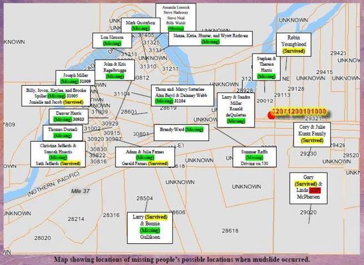
2.Another property map like #1, with no names; red lines around property means ppl known to reside on property? Not sure. Source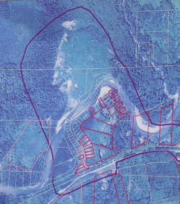
3. Google based topo map of area before landslide; area in red affected area; community and homes clearly visible.Source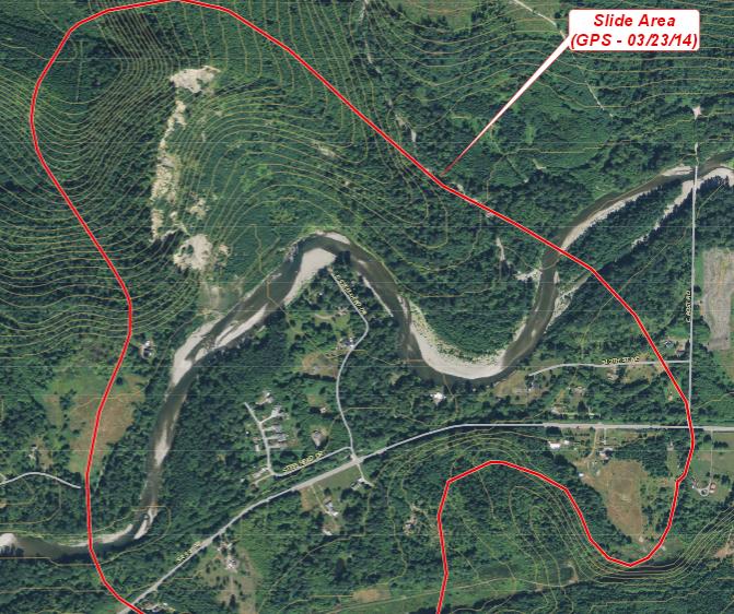
4. Google terrain map I dr.'d in powerpoint; another visual representation of topo involved.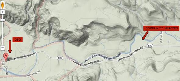
5. USGS EQ map indicating that the community sat squarely on a known small fault line called the Devil's Mt Fault. NO, repeat NO, EQ of any size have been indicated for the area in the last 30 days per USGS. I'm just adding this because I thought it might shed some light as to why the underlying structure of the substrata of this particular spot is so vulnerable (ie: 2006 landslide) Source is USGS eq map but for some reason I can't link it ??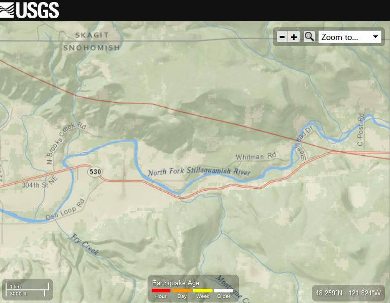
Keep in mind not only the residents are missing but I read where among the missing were a technician installing a satellite dish and a plumber installing a water heater. Who knows who was on the road passing by that could not out run the debris field.
Hope this helps. Prayers to all.
For those of us who are not from the area but are concerned for those that are here are some maps/pics for us that are visually oriented that may help to add context.
1. Looks to be a county property map of residents of the community directly affected, with names of those found/still missing Source

2.Another property map like #1, with no names; red lines around property means ppl known to reside on property? Not sure. Source

3. Google based topo map of area before landslide; area in red affected area; community and homes clearly visible.Source

4. Google terrain map I dr.'d in powerpoint; another visual representation of topo involved.

5. USGS EQ map indicating that the community sat squarely on a known small fault line called the Devil's Mt Fault. NO, repeat NO, EQ of any size have been indicated for the area in the last 30 days per USGS. I'm just adding this because I thought it might shed some light as to why the underlying structure of the substrata of this particular spot is so vulnerable (ie: 2006 landslide) Source is USGS eq map but for some reason I can't link it ??

Keep in mind not only the residents are missing but I read where among the missing were a technician installing a satellite dish and a plumber installing a water heater. Who knows who was on the road passing by that could not out run the debris field.
Hope this helps. Prayers to all.
edit on 25-3-2014 by SCGrits because: fix link
SCGrits
5. USGS EQ map indicating that the community sat squarely on a known small fault line called the Devil's Mt Fault. NO, repeat NO, EQ of any size have been indicated for the area in the last 30 days per USGS.
Actually, not long ago, and in fact, in the last thirty days, there WAS that 6.8 quake on the Gorda plate. It is conceivable that it could have loosened that soil enough to ultimately cause that landslide, even as far away (900-1000km) as it was. If it loosened it enough, other elements such as erosion, water, or foresting could have finished the job. And it was already loose from the previous partial slide in 2006. Not entirely out of the realm of possibility, me thinks.
reply to post by Brandyfro
Brandy, I know some guys from Woolley went down the first day. Search and Rescue was called out, but then got sent back before they got there because it was deemed unsafe. You might want to check in with the woolley department. If you need a contact, PM me and I'll get you a name and #
There seemed to be some confusion tonight over a call for volunteers. During a press conference, they said they needed volunteers to look for bodies tomorrow...but then SnoCo came back and said NO! Don't come, you will be turned back, because National Guard is supposed to be there tonight.
If you are looking for something more along the lines of logistics, you will need to be put in contact with someone on the EOC (emergency command center). With SnoCo DEM and National Guard moving in, that may be a really big mountain to climb, but no harm trying!
(ETA...hate to say this, but I know they are beginning to look downstream for bodies now. That may be something we could try and help with later in the week? I know just enough people that I might be able to find out if and how that might be possible)
edit on 25-3-2014 by westcoast
because: (no reason given)
reply to post by westcoast
Hello all. For what it's worth, I was listening to coast to coast am tonight and on the first hour, a guy came on who was known to George Noory, tonight's host. George asked the guy (I'm sorry I didn't get his name btw) about the flood situation and he said that he thought the 'flood' sounded more like a volcanic event. He had a certain name for it which I can't recall ever hearing before. He said that floods had happened before but it seemed very strange that such HUGE amounts of devastation could occur from a mudslide. It could be just conjecture but I thought I'd throw that out there. I honestly hope to god that as many people can be found alive as possible but it seems that dim candle of hope is badly flickering...
Hello all. For what it's worth, I was listening to coast to coast am tonight and on the first hour, a guy came on who was known to George Noory, tonight's host. George asked the guy (I'm sorry I didn't get his name btw) about the flood situation and he said that he thought the 'flood' sounded more like a volcanic event. He had a certain name for it which I can't recall ever hearing before. He said that floods had happened before but it seemed very strange that such HUGE amounts of devastation could occur from a mudslide. It could be just conjecture but I thought I'd throw that out there. I honestly hope to god that as many people can be found alive as possible but it seems that dim candle of hope is badly flickering...
1FreeThinker
he said that he thought the 'flood' sounded more like a volcanic event. He had a certain name for it which I can't recall ever hearing before. He said that floods had happened before but it seemed very strange that such HUGE amounts of devastation could occur from a mudslide.
You mean a lahar?
en.wikipedia.org...
A lahar /ˈlɑːhɑr/ is a type of mudflow or debris flow composed of a slurry of pyroclastic material, rocky debris, and water. The material flows down from a volcano, typically along a river valley.[1] Lahars are extremely destructive: they can flow tens of metres per second, be 140 metres (460 ft) deep, and destroy any structures in their path. Notable lahars include those at Nevado del Ruiz and Mount Pinatubo, each of which killed thousands of people.
That is reaching a bit far, imo. There is no corroboration of any volcanic activity in this. Landslides happen. Without volcanoes.
reply to post by 1FreeThinker
He's talking about a lahar....or a mud and debris flow that is associated with volcanoes that have ice caps and glaciers on them. The rapid melting of the water causes massive landslides. This slide in Oso was compared to the lahar at Mount Saint Helens that took out spirit lake.
SO...it is a accurate comparison, but not the same cause. The Oso slide was NOT related to a volcano is anyway. It was ground saturation, and they are also saying that the river may have undercut the mountain.
reply to post by TrueAmerican
I was wondering about that TA, but didn't think it was close enough to impact this area this far north.
But I did find this piece of info from the Seattle Times, Risk of slide ‘unforeseen’? Warnings go back decades, which has a lot of very interesting backstory and historical info, but not a word about the Devil's Mt. Fault.
the hillside’s history of slides dates back more than 60 years. One expert says he was shocked when homebuilding was permitted after a big 2006 slide. .....The hill that collapsed last weekend is referred to by geologists with different names, including Hazel Landslide and Steelhead Haven Landslide, a reference to the hillside’s constant movement.
new topics
-
Fire insurance in LA withdrawn months ago
General Conspiracies: 2 hours ago -
Bizarre Labour Party Tic Toc Video Becomes Even More Embarrassing
Regional Politics: 10 hours ago
top topics
-
The elephant in the room (wearing a hoodie)
US Political Madness: 17 hours ago, 15 flags -
Dr. Demento
Music: 17 hours ago, 6 flags -
Fire insurance in LA withdrawn months ago
General Conspiracies: 2 hours ago, 6 flags -
Bizarre Labour Party Tic Toc Video Becomes Even More Embarrassing
Regional Politics: 10 hours ago, 4 flags -
Potter to WHU
World Sports: 16 hours ago, 2 flags
active topics
-
Fire insurance in LA withdrawn months ago
General Conspiracies • 12 • : Boomer1947 -
Los Angeles brush fires latest: 2 blazes threaten structures, prompt evacuations
Mainstream News • 289 • : BeyondKnowledge3 -
The elephant in the room (wearing a hoodie)
US Political Madness • 27 • : Euronymous2625 -
-@TH3WH17ERABB17- -Q- ---TIME TO SHOW THE WORLD--- -Part- --44--
Dissecting Disinformation • 3980 • : AianawaQ1320 -
Judge rules president-elect Donald Trump must be sentenced in 'hush money' trial
US Political Madness • 84 • : Vermilion -
S.C. Jack Smith's Final Report Says Trump Leads a Major Conspiratorial Criminal Organization!.
Political Conspiracies • 47 • : Vermilion -
Statements of Intent from Incoming Trump Administration Members - 2025 to 2029.
2024 Elections • 61 • : cherokeetroy -
Gravitic Propulsion--What IF the US and China Really Have it?
General Conspiracies • 39 • : budbayview -
Its Looking Like Schiff - Vindman - Ciaramella Conspired to Impeach President Trump.
Political Conspiracies • 188 • : WeMustCare -
Trump's idea to make Canada the 51st US state: 'Potential is massive'
Mainstream News • 155 • : DaydreamerX
