It looks like you're using an Ad Blocker.
Please white-list or disable AboveTopSecret.com in your ad-blocking tool.
Thank you.
Some features of ATS will be disabled while you continue to use an ad-blocker.

Ancient Trade Routes
page: 19
share:
I came across this site and felt it was very interesting and has many images of ancient sites and I thought it should be shared here for
discussion.
source
Ancient Trade Routes
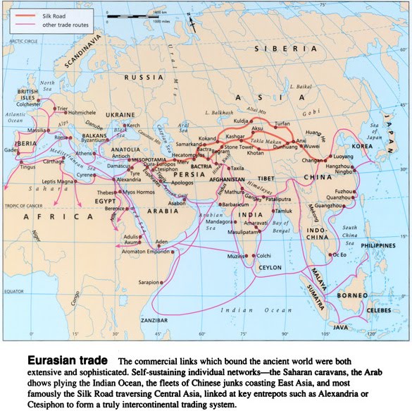
The incidences of megalithic sites, very similar in design, and generally appearing along ancient trade routes and mining activities begs further research. Goods from bitumen, obsidian, jade, worked flint, pottery, and luxury items such as incense and spice have been transported throughout the prehistoric world. Perhaps they served as markers, boarders, and defense lines, weigh stations, processing centers, and housing for migrant workers . If these sites served a utilitarian purpose then their approximations to water ways and trade routes also makes sense. Maps, calendars, road signs, where to find food and shelter are all the same preoccupations I have when traveling. Not all of these stones need have been for defense, nor for any practical purpose at all. The continuity of their design though, through time and space is not explained by proponents of their mystical intentions. I use the word 'intention' as opposed to their 'eventual uses'.
"Few know of the ancient Middle Eastern structures which stretch from Syria to Yemen and could number more than 1 million can now be seen on Google Earth.... The structures have been classified into sub-categories including wheels, rings, pendants and cairns....could have been built up to 9,000 years ago. “These volcanic lava fields are the last place you’d expect to find these kinds of structures,” Kennedy said, “The landscape is not hospitable. It looks bleak and barren. They’re so unusual.” At least 3,000 structures have been found in Jordan....documented nearly 2,000 in Saudi Arabia.
source
edit on 5-3-2014 by AlaskanDad because: (no reason
given)
edit on 5-3-2014 by AlaskanDad because: (no reason given)
edit on 5-3-2014 by AlaskanDad because: typo's and I
used the word many to many times in one sentence - lol's
Iberia has always fascinated me. I doubt they just went North - South and back into the Med.
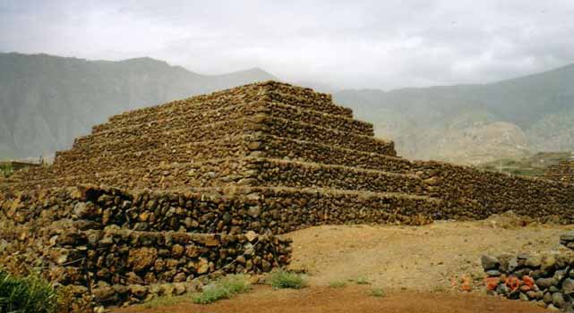
Six step pyramids were discovered in 1998 near Guimar, a town on the eastern shore of Tenerife Island, the Canary Islands. They are still a mystery to archaeologists. The Pyramids of Guimar include six step pyramids with a rectangular ground plan reaching a maximum height of about 12 metres. They have a noticeable similarity to the pyramids built by the Maya and Aztecs in Mexico. They are rubble-filled with facings of black volcanic stone and are the result of multiple episodes of construction.
The main complex of three pyramids were found to be astronomically orientated with the sunset of the summer solstice. Stairways ascend from a level plaza to the top of each pyramid, where there is a flat summit platform covered with gravel. The stairways are all on the west wall, suggesting a ceremonial purpose, because someone ascending them on the morning of the solstice would be directly facing the rising sun.
Spain's Canary Islands off the northwest coast of Africa hardly seem a place for pyramids, but there seem to be six of them on Tenerife. The inhabitants have generally ignored these dilapidated piles of black volcanic stones. However, one perceptive native described them to Thor Heyerdahl of Kon Tiki fame and a leading proponent of cultural diffusion across all oceans.
The Canary Islands had been part of the route Columbus took to the Americas. He stopped in Tenerife for provisions in 1492. The Guanches on Tenerife in 1492 did not permit Columbus or any other Europeans to land on their island. They were not impressed by the physical appearance of the bearded Europeans, who looked like the Guanches themselves. But when Columbus and the Europeans who followed in his wake landed in the New World they were welcomed and initially worshipped as gods, since the beardless Indians they encountered believed that the Spanish belonged to the same people as the legendary founders of their civilization, bearded men from across the Atlantic Ocean.
You don't suppose that once upon a time....
Scientists May Have Found Atlantis
NORTHAMPTON, Mass (Reuters) – A U.S.-led research team may have finally located the lost city of Atlantis, the legendary metropolis believed swamped by a tsunami thousands of years ago in mud flats in southern Spain.
"This is the power of tsunamis," head researcher Richard Freund told Reuters.
"It is just so hard to understand that it can wipe out 60 miles inland, and that's pretty much what we're talking about," said Freund, a University of Hartford, Connecticut, professor who lead an international team searching for the true site of Atlantis.
Alternative source
reply to post by AlaskanDad
Reading through the Source one gets blown away by the trade routes people travelled. At school it was taught that our ancestors were basically savages. But when you realise how long these 'savages' were living and the conditions they survived, I can only have great respect for our ancestors and can now understand the reverence they received.
I read a fascinating article about the salt routes in which it said that these were the first trade links between settlements and then trade graduated on from these.
I am blown away by the amount of megalithic sites around the world that exist. We are clearly underestimating the expanse of megalithic society and I look forward to learning more about them. They open up a new way of thinking about the so called first civilisations and the idea that they arose from literally no sophisticated base whatsoever but developed extremely quickly. I saw that newly discovered megaliths exist in places like Yemen, which it was thought was not inhabited during this era. This now means we will have to do a lot more research into the societies that built these monuments and how or what made them migrate onto the 'big' early civilisations. We appear to have a gap around the 12,000BC odd time where perhaps some catastrophe happened and some of these places were left or many of the people who built them died. With the amount that it is reasonable to think were cosmic observatories, it explains something that has puzzled me for years. Its how these civilisations both in the West and the East who all had similar zodiacs, (allowing for the different symbols for the 12 signs etc, all knew so much about the precession of the equinoxes and the great year and astronomical data that had taken thousands of years to gather and check. It makes sense that the sky was the clock and arrangements for meeting caravans for trade and times of shipping/ travel and meeting up etc, one needed some form of measuring time that everyone could understand and use.
reply to post by SLAYER69
Ok I was amazed Atlantis in Spain was quite a surprise, but I followed a link from one you linked and another surprise followed...
source
Atlanteans in the 12th century boggles the mind!
Ok I was amazed Atlantis in Spain was quite a surprise, but I followed a link from one you linked and another surprise followed...
Dr Kuehne noticed that the war between Atlantis and the eastern Mediterranean described in Plato's writings closely resembled attacks on Egypt, Cyprus and the Levant during the 12th Century BC by mysterious raiders known as the Sea People. As a result, he proposes that the Atlanteans and the Sea People were in fact one and the same.
source
Atlanteans in the 12th century boggles the mind!
edit on 5-3-2014 by AlaskanDad because: (no reason given)
reply to post by Shiloh7
I too was shocked by "the amount of megalithic sites around the world" and I agree 12,000 bc is a time we should be extremely interested in.
So instead of watches and calenders the ancients used megalithic sites, interesting.
I too was shocked by "the amount of megalithic sites around the world" and I agree 12,000 bc is a time we should be extremely interested in.
It makes sense that the sky was the clock and arrangements for meeting caravans for trade and times of shipping/ travel and meeting up etc, one needed some form of measuring time that everyone could understand and use.
So instead of watches and calenders the ancients used megalithic sites, interesting.
reply to post by AlaskanDad
It's interesting isn't it, how such disparate cultures can all share so much iconography and folk tales? Never mind the global 'henges' and mounds that we have. Great thread, I love this kind of thing!
You can make up your own mind as to it's authenticity:
Sacred Texts
There is also a theory that we needed to measure time to avoid comets etc, and become aware of impending disasters in the future, which is something I don't know a whole lot about, but I'm enjoying learning!
edit on 6-3-2014 by beansidhe because: eta
reply to post by AlaskanDad
Great catch.
I've said quite a few times I don't believe the Island of 'Atlantis' ever existed but rather a distant memory passed down by word of mouth from generation to generation of lost Ancient Civilizations along those now submerged ancient ice age coast lines. Now, this shouldn't surprise many if from time to time since being based on an oral history that dates and other unrelated events although seemingly attributed to those ancient tales are just more examples of the fact that we as a species suffer some form of historical amnesia.
reply to post by SLAYER69
Do you not? I'm not sure, really.
I just learned the other day that The Orkney islands, north east of Scotland, used to be of much greater landmass, and that coastal erosion and changing sea levels have effectively 'sunk' some of the land, leaving what we now see as lots of tiny islands.
So I think it's entirely possible that 9000 years ago there could have been landmasses where now there is sea.
reply to post by beansidhe
beansidhe
Thank you for the reply, We should start with what we do know from Accepted 'Science'
Locations such as the Red Sea, Black Sea and even the Persian Gulf did not exist as we know them today. All were created by flooding or the raising of sea levels. The Aegean at one time wasn't such a smattering of small islands.
So it doesn't surprise me that the area you described would have been much larger as the Sea level would have been lower more of the island would have been exposed. For example over in France we have this little gem
 Source
I have some more to contribute later.
beansidhe
Thank you for the reply, We should start with what we do know from Accepted 'Science'
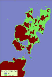
Locations such as the Red Sea, Black Sea and even the Persian Gulf did not exist as we know them today. All were created by flooding or the raising of sea levels. The Aegean at one time wasn't such a smattering of small islands.
Present day Greece & Turkey
[atsimg]http://files.abovetopsecret.com/images/member/ff55edb41226.jpg[/atsimg]Ancient Aegean.
[atsimg]http://files.abovetopsecret.com/images/member/fde840ea31d2.jpg[/atsimg]So it doesn't surprise me that the area you described would have been much larger as the Sea level would have been lower more of the island would have been exposed. For example over in France we have this little gem
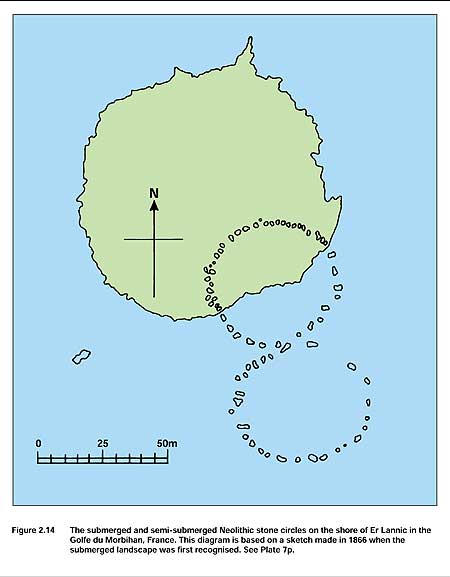
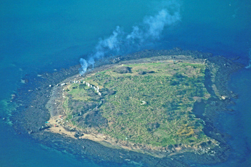
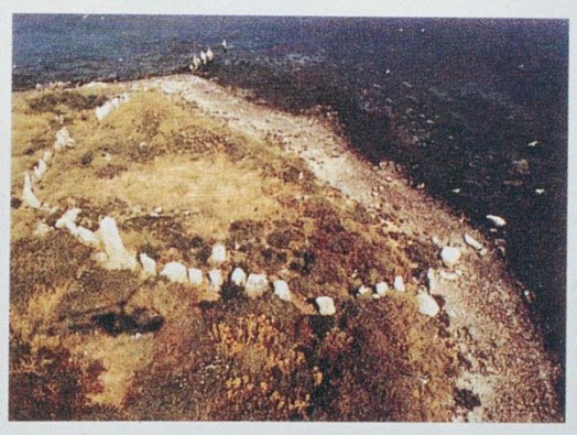
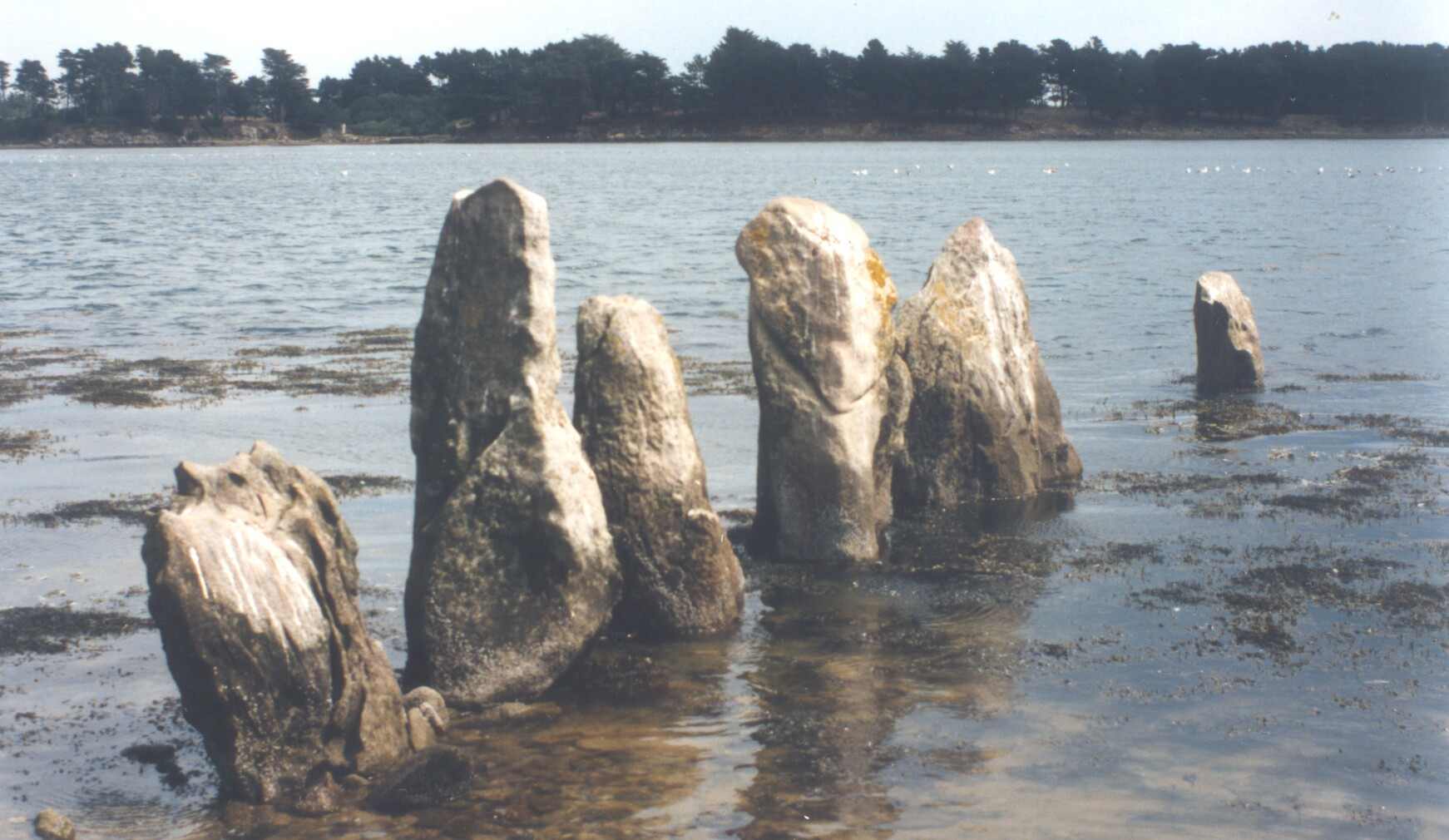
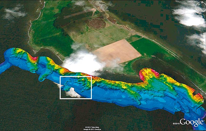
A striking prehistoric example was recognised in the Golfe du Morbihan, France, where, on the tiny island of Er Lannic, a stone circle could by seen rising from the intertidal zone (Lukis 1868; Crawford 1927; Atkinson 1976), (see Figure 2.14, and also Plate 7p). Other semi-submerged megaliths were identified elsewhere on the north-west European seaboard, notably in the creek at Kernic near Plouscat in Finistere and in the ria or submerged valley which now forms the large inlet known as Cork Harbour, Eire (Study Area P20) (see also section 7.42).
While large prehistoric stone monuments in semi-submerged positions presented robust evidence of sea-level rise at a few specific locations on the European seaboard, the recognition of less overt evidence was slow to emerge. Ever since William Borlase had speculated on sea- level changes in the Isles of Scilly in 1753, the issue of the scale and pace of past submergence had been unresolved. Writing in 1927, Crawford drew attention to submerged archaeological evidence in these islands drawing particular attention to ancient stone walls or 'boulder hedges' which could be traced downhill and through the intertidal zone before being lost in the sub-tidal zone. He also noted that the Roman writer Solinus had referred to what appeared to be a single island, Siluram insulam, when he was apparently describing this place in the 3rd century AD (Crawford 1927)
I have some more to contribute later.
edit on 7-3-2014 by SLAYER69 because: (no reason given)
reply to post by SLAYER69
That is interesting, because it's very similar to Orkney; my knowledge of these things is more parochial, I'm afraid!
Antiquity Journal
And a very interesting review of an initial dive to explore the suspected neolithic sites under water:
The Rising Tide
And I'll add this, as it's quite exciting:
Massi ve underwater monument at Stennes henge?
These are all important elements when we think about ancient trade routes, as I suppose we're just saying these are the remaining trade routes that we're aware of, as we look at our landscape today. Thankfully there is work happening, almost constantly in Orkney, to try and understand more and more.
There were tsunamis in Scotland, which as I'm sure you know, are well documented.
Wiki -Tsunami Scotland
So with just this little example from this tiny corner of the globe, it doesn't seem unreasonable that a much larger landmass could have existed thousands of years ago. The problem I suppose is that Plato is too modern in some respects, and it has never been agreed whether his story was allegorical or based on a story he knew.
That is interesting, because it's very similar to Orkney; my knowledge of these things is more parochial, I'm afraid!
Antiquity Journal
And a very interesting review of an initial dive to explore the suspected neolithic sites under water:
The Rising Tide
And I'll add this, as it's quite exciting:
Massi ve underwater monument at Stennes henge?
These are all important elements when we think about ancient trade routes, as I suppose we're just saying these are the remaining trade routes that we're aware of, as we look at our landscape today. Thankfully there is work happening, almost constantly in Orkney, to try and understand more and more.
There were tsunamis in Scotland, which as I'm sure you know, are well documented.
Wiki -Tsunami Scotland
The east coast of Scotland was struck by a 70 feet (21 m) high tsunami around 6100 BC, during the Mesolithic period. The wave was caused by the massive underwater Storegga slide off Norway, which occurred then. The tsunami even washed over some of the Shetland Islands. Tsunamite (the deposits left by a tsunami) dating from this event can be found at various locations around the coastal areas of Scotland, and are also a tourist feature in the Montrose Basin, where there is a layer of deposited sand about 0.6 metres (2.0 ft) thick.
So with just this little example from this tiny corner of the globe, it doesn't seem unreasonable that a much larger landmass could have existed thousands of years ago. The problem I suppose is that Plato is too modern in some respects, and it has never been agreed whether his story was allegorical or based on a story he knew.
reply to post by beansidhe
I agree that these ancient trade routes were probably based on ancient known locations in prehistory. I think our history due to so many varying contributing factors has been forgotten except in oral history that in my opinion is often scoffed at as myth and legend before recorded history was established.
Recorded history also has gotten, burned, looted and destroyed all too often by those with apposing Religious, Political, and Ideological agendas because it didn't fit in with the small minded Paradigms of the periods.
Library of Alexandria, The burning of Mayan Codices, Chinese rulers ordering the destruction of all literature etc etc etc...
new topics
-
Elena Zelenskaya bought one of the most expensive supercars, Bugatti Turbillon
Politicians & People: 4 minutes ago -
For Stating JOE BIDEN Won in 2020 Due to Fraud - RUDY GIULIANI Loses His NY Law License.
US Political Madness: 1 hours ago -
Key Democrat donors threaten to pull plug or the emperor's new cognitive decline
2024 Elections: 6 hours ago -
How Russian cities have changed under Putin
ATS Skunk Works: 7 hours ago -
Let's talk about Jamie Foxx's headache and psychics/NDE
General Chit Chat: 8 hours ago -
They rolled out another joe today
US Political Madness: 10 hours ago -
The Biden Crime Syndicate
US Political Madness: 11 hours ago
top topics
-
Looks Like a Global Red Tide ..
Political Ideology: 17 hours ago, 28 flags -
The Biden Crime Syndicate
US Political Madness: 11 hours ago, 12 flags -
Nations oldest Citizen dies at age 110
People: 17 hours ago, 9 flags -
They rolled out another joe today
US Political Madness: 10 hours ago, 8 flags -
For Stating JOE BIDEN Won in 2020 Due to Fraud - RUDY GIULIANI Loses His NY Law License.
US Political Madness: 1 hours ago, 7 flags -
Key Democrat donors threaten to pull plug or the emperor's new cognitive decline
2024 Elections: 6 hours ago, 6 flags -
How Russian cities have changed under Putin
ATS Skunk Works: 7 hours ago, 5 flags -
Let's talk about Jamie Foxx's headache and psychics/NDE
General Chit Chat: 8 hours ago, 1 flags -
Elena Zelenskaya bought one of the most expensive supercars, Bugatti Turbillon
Politicians & People: 4 minutes ago, 0 flags
active topics
-
Hey Lefties, can we talk about this yet?
US Political Madness • 277 • : Sookiechacha -
Elena Zelenskaya bought one of the most expensive supercars, Bugatti Turbillon
Politicians & People • 1 • : chiefsmom -
For Stating JOE BIDEN Won in 2020 Due to Fraud - RUDY GIULIANI Loses His NY Law License.
US Political Madness • 16 • : WeMustCare -
BREAKING: TRUMP WINS! Supreme Court Rules 6-3 on Presidential Immunity
Mainstream News • 228 • : fringeofthefringe -
Let's talk about Jamie Foxx's headache and psychics/NDE
General Chit Chat • 5 • : Drugstorecowboy56 -
Looks Like a Global Red Tide ..
Political Ideology • 30 • : Athetos -
Hurricane Beryl, now an ‘extremely dangerous’ Category 4 storm, heads for the Caribbean
Fragile Earth • 15 • : StudioNada -
-@TH3WH17ERABB17- -Q- ---TIME TO SHOW THE WORLD--- -Part- --44--
Dissecting Disinformation • 1626 • : Thoughtful3 -
Key Democrat donors threaten to pull plug or the emperor's new cognitive decline
2024 Elections • 27 • : putnam6 -
Purported UFO Photos from US Submarine
Aliens and UFOs • 11 • : Ophiuchus1
9