It looks like you're using an Ad Blocker.
Please white-list or disable AboveTopSecret.com in your ad-blocking tool.
Thank you.
Some features of ATS will be disabled while you continue to use an ad-blocker.

How do I know if it's Chemtrails or not? Pictures from my neighborhood today.
page: 11share:
reply to post by Char-Lee
Obviously I was typing that last response as you posted, thank you.
The thing about what you have seen is that I have seen the same here, I have tracked these flights and made posts on them, if you would like to read on what I saw and what my explanations were I can post a link for you. I have some images on my camera from the other day I want to upload to explain a point but I haven't done that yet.
Now if my observations match your precisely, then it may offer you an explanation. If not then you may have seen something else which is why the data is important.
reply to post by Char-Lee
Please, if you feel someone has been rude to you, use the alert button. The moderators are very active on policing this forum.
The problem is, you saw something that if you gave dates, and locations to, it could either be explained with flight tracking software, (like it was in a holding pattern, or it was a test flight) or it was an honest to goodness spray operation.
Everyone here is at least aware of the fact that conspiracies exist. If you have proof of a conspiracy, then it is no longer a conspiracy, it's a fact. So in the spirit of learning and sharing information, please, document and photograph these things if at all possible.
reply to post by Char-Lee
Are you sure...
Please look at their paths they do not fly out to sea and toward land from sea making squares.
Are you sure...
reply to post by tsurfer2000h
yes I am sure 20 years of observation. Look up Crescent City Ca and look at our traffic.
yes I am sure 20 years of observation. Look up Crescent City Ca and look at our traffic.
reply to post by Char-Lee
This screenshot from FR24 shows how crowded the skies are nearby, if not directly overhead. This is of course a snapshot of one moment too.

As this graphic shows, on a persistence day that traffic would leave lots of visible contrails right in your line of sight, as per your photos a few days ago. You may be surprised how distant some trails you're seeing are.

This screenshot from FR24 shows how crowded the skies are nearby, if not directly overhead. This is of course a snapshot of one moment too.
As this graphic shows, on a persistence day that traffic would leave lots of visible contrails right in your line of sight, as per your photos a few days ago. You may be surprised how distant some trails you're seeing are.
reply to post by Char-Lee
Always remember, just because you don't see a trail, doesn't mean there are no airplanes in the sky. They are hard to spot unless you are looking for them sometimes. (I'm not sure, was that rude?)
Always remember, just because you don't see a trail, doesn't mean there are no airplanes in the sky. They are hard to spot unless you are looking for them sometimes. (I'm not sure, was that rude?)
reply to post by Char-Lee
If there is wind, and there usually is at FL300 or so, then those distant trails can soon be blown by the wind to a position near you.
If you see aircraft directly overhead, well go on flight radar 24 and see if it's on there and identify it, then post images of both the aircraft in the sky and on the web, and prove it is either chemtrailing or a normal airliner.
That should be pretty simple, no?
Char-Lee
reply to post by waynos
I am not talking distant but why bother.
To exchange and understand information. If it's not too much trouble.
Char-Lee
yes I am sure 20 years of observation. Look up Crescent City Ca and look at our traffic.
Char-Lee,
As you have correctly observed while watching the sky is the J and Q upper air routes to the east of Crescent City.
What you have failed to understand is the routes and waypoints that take airliners to the west of Crescent City. These routes and waypoints have been there for years and are regularly used. Did you know that airspace even existed and that the contrails, depending on winds, can and will be blown over land and your location?
Control 1416H
That airspace extending upward from 18,000 feet MSL to and including FL 450 bounded by a
line beginning at lat. 43°46'54''N., long. 126°37'47''W.; to lat. 41°23'23''N., long. 124°45’'51''W.;
to lat. 40°42'42''N., long. 124°09'20''W.; to lat. 40°37'43''N., long. 124°18'41''W.; to lat.
41°17'24''N., long. 124°57'01''W.; to lat. 42°35'56''N., long. 126°45'03''W.; to the point
of beginning.
www.faa.gov...
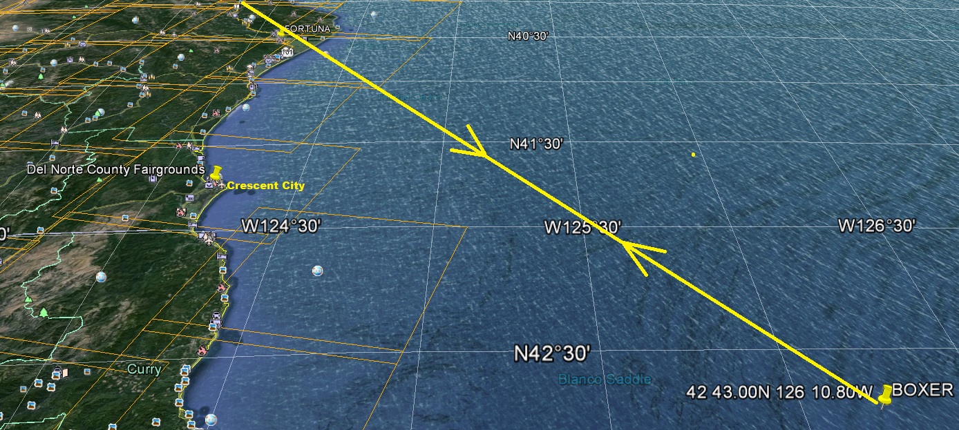
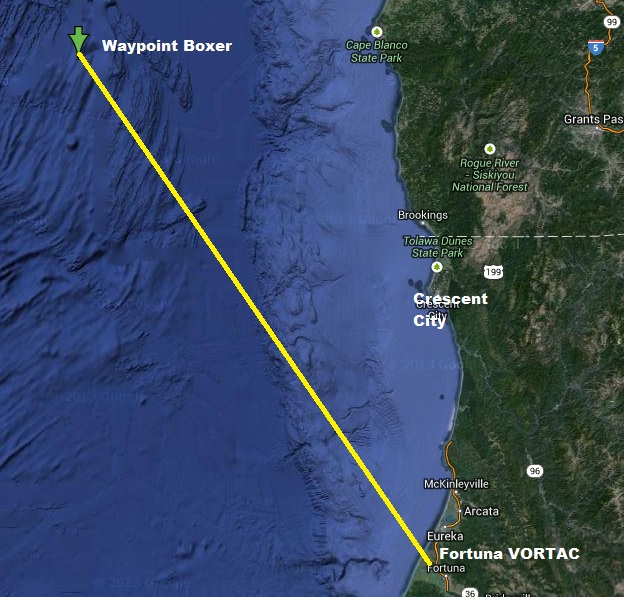
Go to the following website (SkyVector) type in KCEC in the box top left. This will orientate the map to Crescent City. Make sure the setting is on 'World Hi' from the clickable on the right.
skyvector.com...
On the SkyVector map go south and find the symbol for Fortuna VORTAC. Now look to the North West of Crescent City and find the triangle in the ocean marked Boxer 42 43.00N 126 10.80W
goo.gl...
You will also see on the SkyVector map the airspace listed as Control 1416H
Fortuna VORTAC
goo.gl...
40 40.277939N 124 14.100037W
Fortuna VORTAC map link
en.wikipedia.org...
Take for example Flight CA987 Air China Boeing 777 on the 21st December flying from Beijing to Los Angeles.
Watch it on Flight Radar
Boeing 777 CA987 Flight Radar
uk.flightaware.com...
Note the waypoint route. I've highlighted BOXER and FORTUNA.
URABI G212 VALDA H222 MCG J111 TED J804R NOWEL J804R MDO B453 BOXER FOT ENI OAK J1 AVE SADDE6
You have taken the images from the Del Norte County Fairgrounds parking lot. In the second one you are facing south.
goo.gl...
Map orientated south showing the airspace and some of the waypoints that take airliners west of Crescent City.
In the first one you are facing north westerly from the Del Norte County Fairgrounds parking lot.
Map orientated North showing the airspace route out from Fortuna VORTAC to waypoint Boxer.
Examples of some flights that used the airspace and waypoints on the 21st December 2013.
Air China CA985 Boeing 747 Beijing to San Francisco 21st December.
Watch the flight on the following link
Boeing 747 Air China CA985 Flight Radar 24
uk.flightaware.com...
Route Waypoints - Note BOXER and FOT
YV B334 TGO G212 FYU G212 IJ G212 ARGUK G212 BUMAT G212 VALDA H222 SLEDD H222 MCG J111 TED J804R MDO B453 BOXER FOT GOLDN6
Boeing 777 Air China 988 CA988 Los Angeles to Beijing
flightaware.com...
RZS J88 PYE J143 ENI FOT BOXER B453 KANUA B453 MDO J804R TED J111 UNK FDV G212 GIRLO
G212 ARNAP R213 MAGIT R213 JMU G212 DABMA W74 SABEM G332 GITUM
Watch the flight at following link
Boeing 777 Air China CA988 Flight Radar 24
In addition to BOXER there is also further on waypoint KYLLE 43 26 40N 126 39 40W
goo.gl...
Boeing 737 Alaska Airlines 159 AS159 Los Angeles to Anchorage
flightaware.com...
VTU5 RZS J88 PYE J143 ENI FOT KYLLE B453 KANUA B453 MDO YESKA5
Watch the flight at following link
Boeing 737 Alaska Airlines AS159 Flight Radar 24
McDonnell Douglas MD-11 EVA Airways EVA609 Los Angeles to Anchorage
flightaware.com...
VTU5 RZS J88 SNS J110 OAK BOXER B453 KYLLE B453 KURTT B453 KATCH B453 MDO YESKA5
Watch the flight on following link
MD-11 EVA Airways EVA609 Flight Radar 24
Now take into consideration the true airspace around you the wind will sometimes do the rest in relation to contrails that you see.
contrailscience.com...
contrailscience.com...
reply to post by waynos
Say and think what you will. My photos the other day didn't show much of the sky.
The jets in Brookings OR making the grid quickly were military, two jets.
Maybe they are aware Yellowstone or long valley may be near blowing and are preparing by adding to the atmosphere while they can. I am sure there is a reason and it is not normal air traffic.
www.newscientist.com...
Say and think what you will. My photos the other day didn't show much of the sky.
The jets in Brookings OR making the grid quickly were military, two jets.
Maybe they are aware Yellowstone or long valley may be near blowing and are preparing by adding to the atmosphere while they can. I am sure there is a reason and it is not normal air traffic.
According to Graf's model, the vast sulphur emissions created sulphate particles that grew large and so reflected less light, reducing the cooling effect (Geophysical Research Letters, doi.org/cpk3fm).
www.newscientist.com...
reply to post by Char-Lee
In case anyone wanted to read the whole paragraph.
Lane agrees that there might have been a short-term period of severe cooling, but because more dramatic dips have occurred without affecting humans, the shift was unexceptional.
Hans-F Graf of the University of Cambridge, who has also modelled the effects of supervolcanoes on climate, agrees. According to Graf's model, the vast sulphur emissions created sulphate particles that grew large and so reflected less light, reducing the cooling effect (Geophysical Research Letters, doi.org/cpk3fm).
In case anyone wanted to read the whole paragraph.
reply to post by Lifesclan
Was this ever resolved?
I am seeing the EXACT same thing...
I can't add my pictures to the post. When I click on the "insert an image from your library" button only a black box with a green 'x' appears
Was this ever resolved?
I am seeing the EXACT same thing...
Murgatroid
reply to post by Lifesclan
I can't add my pictures to the post. When I click on the "insert an image from your library" button only a black box with a green 'x' appears
Was this ever resolved?
I am seeing the EXACT same thing...
not sure what you mean by "library"??
I include pictures by uploading them here to ATS (the upload function is in the secondary menu at the top of the page accessed by the "v" icon that is in negative) then pasting the image's BB code - which you get by clicking on it in the uploads section.
you already used the word "chemtrail" so that means there's already no hope for you at all. the word you were looking for was "contrail", which
is what you saw, and it's the only thing you can see at that altitude. thank goodness you didn't say "bigfoot" or "hillary", sorry, i have a
hard time telling those two apart. remember, its "contrail" - real, not "chemtrail"- which is secret service slang for cleaning air force one when
the politicians get done using it. all that coc aine and absynthe stains the upholstry ! ! ! ! ! !
reply to post by Aloysius the Gaul
Thanks for responding Aloysius BTW...
We are talking about two different things.
When ever I try to place images in posts this is what I get:

Aloysius the Gaul
not sure what you mean by "library"??
I include pictures by uploading them here to ATS (the upload function is in the secondary menu at the top of the page accessed by the "v" icon that is in negative) then pasting the image's BB code - which you get by clicking on it in the uploads section.
Thanks for responding Aloysius BTW...
We are talking about two different things.
When ever I try to place images in posts this is what I get:
reply to post by Murgatroid
After you upload a picture you must click your photo open, it will than have several options at the bottom. One is used to put in posts, you copy it and simply past it in the post.
After you upload a picture you must click your photo open, it will than have several options at the bottom. One is used to put in posts, you copy it and simply past it in the post.
I don't know which is the best way to do it, but if it's any help I use a photobucket album for uploading. This then gives you an img tag for each
picture you put up so whenever you want to use an image you simply click the tag under it and paste it straight into your post.
On some of my older posts from before I did this the images are no longer there, but every photobucket link I've ever used seems to be present and correct, so I stick with it for reliability (so far!)
On some of my older posts from before I did this the images are no longer there, but every photobucket link I've ever used seems to be present and correct, so I stick with it for reliability (so far!)
Char-Lee
After you upload a picture you must click your photo open, it will than have several options at the bottom. One is used to put in posts, you copy it and simply past it in the post.
Hmmm. interesting...
That's actually what I've been doing.
It seems like we used to be able to click that button to do this.
Is that button just BROKE or does it serve some other future purpose?
reply to post by jhn7537
Isn't it funny how vehemently these average Joe's come out to deny them though? I mean rather than just skip another central thread they come on and condescending like they have a stake in it.
Personally I don't have an answer. I do think the alleged contrails are much lower and seen in crossbar much more than when I was younger and more importantly.. whats so hard to believe about thw government spraying for any of a million reasons. They decided fluoride is good for water.. how do any of these armchair experts know the gov hasn't decided it would be beneficial to spray something.
Again.. it is bizarre how intense the anti central people are.
new topics
-
Really Unexplained
Paranormal Studies: 1 hours ago -
The Vaccine Injured
Medical Issues & Conspiracies: 1 hours ago -
Leading Surgeon from Al-Shifa Hospital Dies in Israeli Custody
Middle East Issues: 4 hours ago -
Zionists of ATS assemble
Political Issues: 8 hours ago
top topics
-
EPA sues San Francisco for dumping billions of gallons of sewage into Pacific Ocean
US Political Madness: 13 hours ago, 10 flags -
UN Estimates Rebuilding Gaza Will Cost Up To 40 Billion Dollars
Middle East Issues: 17 hours ago, 9 flags -
For Votes - President BIDEN Opens ObamaCare Health Ins to Illegal Aliens Eff Nov 1st 2024.
2024 Elections: 13 hours ago, 9 flags -
Zionists of ATS assemble
Political Issues: 8 hours ago, 6 flags -
Leading Surgeon from Al-Shifa Hospital Dies in Israeli Custody
Middle East Issues: 4 hours ago, 3 flags -
The Vaccine Injured
Medical Issues & Conspiracies: 1 hours ago, 1 flags -
Really Unexplained
Paranormal Studies: 1 hours ago, 1 flags -
Prophets versus priests; - Getting God's help
Religion, Faith, And Theology: 15 hours ago, 0 flags
active topics
-
Leading Surgeon from Al-Shifa Hospital Dies in Israeli Custody
Middle East Issues • 24 • : HopeForTheFuture -
Really Unexplained
Paranormal Studies • 3 • : mysterioustranger -
The Vaccine Injured
Medical Issues & Conspiracies • 4 • : PrivateAngel -
UN Estimates Rebuilding Gaza Will Cost Up To 40 Billion Dollars
Middle East Issues • 56 • : YourFaceAgain -
Russia Ukraine Update Thread - part 3
World War Three • 5750 • : YourFaceAgain -
SEC shuts down Trump Media auditor, BF Borgers, over fraud
Mainstream News • 50 • : worldstarcountry -
Prophets versus priests; - Getting God's help
Religion, Faith, And Theology • 2 • : Astyanax -
A Couple Of Great Movies Ive Watched Today
General Chit Chat • 13 • : Bilbous72 -
Zionists of ATS assemble
Political Issues • 29 • : Coelacanth55 -
-@TH3WH17ERABB17- -Q- ---TIME TO SHOW THE WORLD--- -Part- --44--
Dissecting Disinformation • 791 • : RelSciHistItSufi