It looks like you're using an Ad Blocker.
Please white-list or disable AboveTopSecret.com in your ad-blocking tool.
Thank you.
Some features of ATS will be disabled while you continue to use an ad-blocker.

Mystery arrows in the desert
page: 18
share:
Mystery arrows
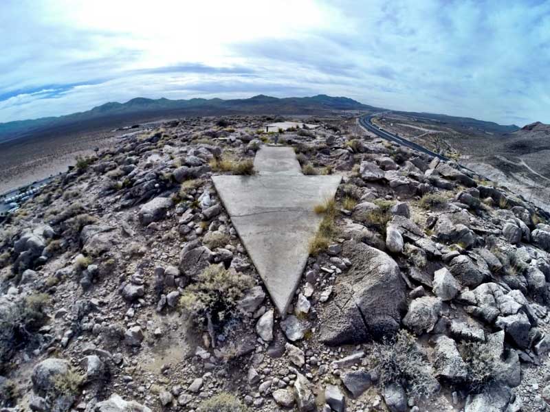
Not exactly a base, but Groom Lake investigator and occasional ATS Ask Me Anything participant, plus trusty videographer Matt, did a piece on mysterious arrows in the desert. Apparently they were used in air mail delivery.
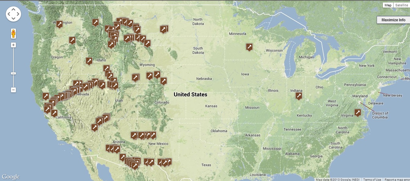
In the article there is a link to where to find the arrows.
Not exactly a base, but Groom Lake investigator and occasional ATS Ask Me Anything participant, plus trusty videographer Matt, did a piece on mysterious arrows in the desert. Apparently they were used in air mail delivery.
In the article there is a link to where to find the arrows.
reply to post by gariac
wewww..in the article this not only one arrow but many of them..its odd, do you know where this arrow pointing? maybe there an image from above?
Tq for the morning Mystery..SnF
wewww..in the article this not only one arrow but many of them..its odd, do you know where this arrow pointing? maybe there an image from above?
Tq for the morning Mystery..SnF
reply to post by gariac
That is a cool story. If I had stumbled upon on, I would have no clue. Clearly man made and clearly modern. But past that?
That is a cool story. If I had stumbled upon on, I would have no clue. Clearly man made and clearly modern. But past that?
reply to post by cheesy
There is a link in the article which goes to a google map and satellite page, but no coordinates. But we can figure them out in short order.
Map link
There is a link in the article which goes to a google map and satellite page, but no coordinates. But we can figure them out in short order.
Map link
ABNARTY
reply to post by gariac
That is a cool story. If I had stumbled upon on, I would have no clue. Clearly man made and clearly modern. But past that?
and the purpose clearly for the above sight only..
reply to post by gariac
well now we know the "purpose" they say,but..
so many of them not pointing 1 place..if they say for mail service..
In the years following World War I, in response to pilots of the fledgling airmail service getting lost, and often crashing, the government built a network of giant concrete arrows and beacons that would lead the pilots safely along their route.
well now we know the "purpose" they say,but..
so many of them not pointing 1 place..if they say for mail service..
edit on 20-11-2013 by cheesy because: (no reason given)
I suspect it is the "sloan" arrow in the article. On Google Earth: 35°57'11.80"N 115°10'45.39"W
Moapa site: 36°41'7.04"N 114°31'3.39"W
I think this is one of the beacon towers: 36°41'6.82"N 114°31'12.01"W
Virgin River arrow: 36°47'48.39"N 114°14'47.52"W
OK, that's it for me.
Moapa site: 36°41'7.04"N 114°31'3.39"W
I think this is one of the beacon towers: 36°41'6.82"N 114°31'12.01"W
Virgin River arrow: 36°47'48.39"N 114°14'47.52"W
OK, that's it for me.
edit on 20-11-2013 by gariac because: (no reason given)
edit on 20-11-2013 by gariac because: (no reason
given)
edit on 20-11-2013 by gariac because: (no reason given)
reply to post by gariac
There are other more weathered ground patterns in the area 51 area such as this less obvious and overgrown fish like glyph.

Sorry for some reason the image has uploaded at a vastly reduced resolution that is no good for viewing so here are the google earth coordinates and other details.
The image date is 8.23.2011
37 degrees 13 minutes 20.96 seconds north 115 degrees 52 minutes 38,51 seconds west elev 1363 m eye alt 1.95 km
Nothing unusual but very strange and maybe these ground glyphs served a similar purpose for aeriel orientation during test flights.
reply to post by LABTECH767
There is a tendency when starting at Google Earth too much to become subject to pareidolia. Or as Freud would say, "Sometimes a cigar is just a cigar." Pareidolia is often mentioned by "skeptics" when discussing Virgin Mary sightings.
Having looked at a lot of interesting stuff on Google Earth, then going there in person, you are often disappointed. Some things, like those emergency runways around the NTTR, can't even be seen on the ground. When you see a barren spot of ground, then get there in person, it doesn't appear to have been subject to any "trauma", oh, like a plane crash. I don't recall the proper geological terminology, but when there is rock just beneath the soil, i.e. a potential rock outcropping if it wasn't for a bit of dirt, the dirt can't support much in the way of plant life. The geologists also talk about some dirt actually being "weathered rock", which doesn't support much plant life either. So there are lots of natural explanations for patterns in the earth.
Some people see earth patterns here: 38° 2'1.65"N 115°26'37.92"W ;-)
reply to post by cheesy
Well, to me they seem to be pointing exactly to one place: north-east. At least the few ten i took a closer look at.
Well, to me they seem to be pointing exactly to one place: north-east. At least the few ten i took a closer look at.
Yup air navigation arrows from the days before radar and GPS. There used to be towers topped with lighted beacons over the arrows. Heres an
interesting link discribing the system.
wchsutah.org...
Just a question .. When these arrows were made, couldn't pilots use a compass and a map ? What if these arrows couldn't be seen due to bad
visibility .. Just a thought
ThePeaceMaker
Just a question .. When these arrows were made, couldn't pilots use a compass and a map ? What if these arrows couldn't be seen due to bad visibility .. Just a thought
Photo of plane
Well we know they didn't have a pressurized cabin based on the photo. So they were certainly flying under 10kft. I think they could see the beacons in most cases. Their biggest problem was probably not being able to fly over bad weather.
To navigate with a compass, you need to know where you are as well as which way to go. I could see this being difficult once you left the airport since without these towers, all you would have are landmarks to indicate where you are. Get off course a little bit, and you may not see the landmark. Even today, there are still pilots that land at the wrong airport. There was one just a few days ago:
747 lands at wrong airport
Better yet:
C-17 lands at wrong airport
reply to post by gariac
Thanks gariac I guess I didn't think about flying heights during them times. I always thought that a flight had a pre planned route, like they get a map and plan way points prior to taking off. Then once you got your way points you just use compass bearings at each way point. I guess I don't think in depth about things sometimes
Oh and the 747 and c-17 I saw that yesterday made me chuckle
ThePeaceMaker
reply to post by gariac
Thanks gariac I guess I didn't think about flying heights during them times. I always thought that a flight had a pre planned route, like they get a map and plan way points prior to taking off. Then once you got your way points you just use compass bearings at each way point. I guess I don't think in depth about things sometimes
Oh and the 747 and c-17 I saw that yesterday made me chuckle
Well don't get me wrong here. I mean you can just fly VFR (visual flight rules) with no flight following and do whatever you want. Helicopter flights are generally VFR. But it may not be a good plan for cross country flight.
Most parts of the country use the frequency 123.4 for helicopter chit chat. Since they can be anywhere and everywhere, collisions are a potential problem. But not following flight routes means if you go down, you are significantly harder to find. Helicopters these days often use a satellite tracking system. The FAA doesn't get the feed as far as I know, but you have a responsible party on the ground that keeps track of your flight. There are a lot of holes in FAA radar. If you listen to Nellis control, they lose radar contact with light aircraft flying along route 95 in certain areas.
Above a certain altitude, instrument flight is required.
reply to post by gariac
Thanks gariac I don't class myself as an expert I just like saying what's in my head and seeing other peoples opinions and knowledge
Cheers!
Thanks gariac I don't class myself as an expert I just like saying what's in my head and seeing other peoples opinions and knowledge
Cheers!
roncoallstar
I created a thread about something similar awhile ago. Check it out.
Sonoran Desert
Most of what you found are training ranges. I don't know about the triangle, but the star pattern is typical of air defenses. A guru could look at them and tell you what country based on the pattern.
There is a mock air defense site on the NTTR at 37°35'24.18"N 115°54'29.24"W . They call this the Russian Radar Site, but all of the people the US considers hostile use Russian military gear. So really it could be any country using Soviet era air defense gear.
Site-4: 37°43'38.25"N 116°31'48.70"W
Star patterns at the "Korean airfield" : 37°24'4.84"N 116°52'4.36"W
This blogger would probably give you a definitive answer to what you found, but you might want to see if he has already written about the area.
IMINT and analysis
At one time he was a secret blogger, but is now out in the open. He is a contributor to Janes, so I would say he probably knows his stuff.
new topics
-
Big Storms
Fragile Earth: 16 minutes ago -
Where should Trump hold his next rally
2024 Elections: 2 hours ago -
Shocking Number of Voters are Open to Committing Election Fraud
US Political Madness: 3 hours ago -
Gov Kristi Noem Shot and Killed "Less Than Worthless Dog" and a 'Smelly Goat
2024 Elections: 4 hours ago -
Falkville Robot-Man
Aliens and UFOs: 4 hours ago -
James O’Keefe: I have evidence that exposes the CIA, and it’s on camera.
Whistle Blowers and Leaked Documents: 5 hours ago -
Australian PM says the quiet part out loud - "free speech is a threat to democratic dicourse"...?!
New World Order: 6 hours ago -
Ireland VS Globalists
Social Issues and Civil Unrest: 6 hours ago -
Biden "Happy To Debate Trump"
2024 Elections: 7 hours ago -
RAAF airbase in Roswell, New Mexico is on fire
Aliens and UFOs: 7 hours ago
top topics
-
A Warning to America: 25 Ways the US is Being Destroyed
New World Order: 17 hours ago, 21 flags -
Blast from the past: ATS Review Podcast, 2006: With All Three Amigos
Member PODcasts: 9 hours ago, 13 flags -
James O’Keefe: I have evidence that exposes the CIA, and it’s on camera.
Whistle Blowers and Leaked Documents: 5 hours ago, 12 flags -
Australian PM says the quiet part out loud - "free speech is a threat to democratic dicourse"...?!
New World Order: 6 hours ago, 12 flags -
Biden "Happy To Debate Trump"
2024 Elections: 7 hours ago, 11 flags -
Mike Pinder The Moody Blues R.I.P.
Music: 9 hours ago, 8 flags -
What is the white pill?
Philosophy and Metaphysics: 8 hours ago, 6 flags -
Shocking Number of Voters are Open to Committing Election Fraud
US Political Madness: 3 hours ago, 5 flags -
Ireland VS Globalists
Social Issues and Civil Unrest: 6 hours ago, 5 flags -
RAAF airbase in Roswell, New Mexico is on fire
Aliens and UFOs: 7 hours ago, 5 flags
active topics
-
Big Storms
Fragile Earth • 2 • : xuenchen -
Massachusetts Drag Queen Leads Young Kids in Free Palestine Chant
Social Issues and Civil Unrest • 21 • : ToneD -
Biden "Happy To Debate Trump"
2024 Elections • 49 • : TheMisguidedAngel -
Candidate TRUMP Now Has Crazy Judge JUAN MERCHAN After Him - The Stormy Daniels Hush-Money Case.
Political Conspiracies • 816 • : xuenchen -
Where should Trump hold his next rally
2024 Elections • 13 • : Edumakated -
Shocking Number of Voters are Open to Committing Election Fraud
US Political Madness • 6 • : marg6043 -
University of Texas Instantly Shuts Down Anti Israel Protests
Education and Media • 312 • : marg6043 -
Gov Kristi Noem Shot and Killed "Less Than Worthless Dog" and a 'Smelly Goat
2024 Elections • 30 • : TheMisguidedAngel -
President BIDEN's FBI Raided Donald Trump's Florida Home for OBAMA-NORTH KOREA Documents.
Political Conspiracies • 36 • : BingoMcGoof -
ALERT - U.S. President JOE BIDEN Examined and Found NOT OF SOUND MIND.
2024 Elections • 64 • : WeMustCare
8