It looks like you're using an Ad Blocker.
Please white-list or disable AboveTopSecret.com in your ad-blocking tool.
Thank you.
Some features of ATS will be disabled while you continue to use an ad-blocker.

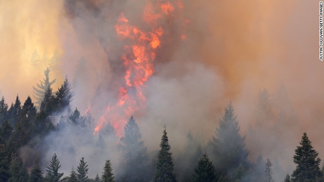
California state of emergency. The "Rim Fire"
page: 2share:
Originally posted by randomtangentsrme
reply to post by Mizzijr
70 thousand acres is small to mid sized
en.wikipedia.org...
The fire is now over 100,000 acres with 2% containment and evacuations ordered. That's a big fire and I don't care what Wiki says. I have lived in California most of my life and would consider this a pretty dangerous situation.
www.kcoy.com...
The only good thing is that the fire is in a very low populated area, for now at least. It's very difficult terrain to fight it, along with the dry
and windy conditions, it'll probably end up being the largest in state history, The 2003 Cedar Fire in San Diego burned 280K+ acres.
I've evacuated 4 times, but thankfully have never lost anything.
I've evacuated 4 times, but thankfully have never lost anything.
reply to post by missvicky
I saw that this morning, I would agree at this point it is a large fire. I wouldn't agree that it's dangerous, except to those who are fighting it and those to stubborn to get away from it.
Perhaps my divide from the majority of posters on this thread, is that I have seen this countless times, and while never a victim myself, have had folks close to me lose possessions, or loved ones due to natural disasters, specifically fires.
They all moved on with their life. Some doing so multiple times. Yes it sucks people are going to lose their homes, but they will be rebuilt. They have time to remove any non replaceable items (photos, pets, etc). Plus as I mentioned earlier if the fire moves to developed areas it will be much easier to contain.
This is terrible, Yosemite is one of the greatest natural parks in our country and it is just horrible to see it burning this badly.
I have some family near San Francisco so am i curious to know if anyone has heard an update on the situation with their power grid?
Oh, and look, faces in the flames.
Anyway...
USA Today
Making it's own weather patterns? Thats seems pretty intense.
I have some family near San Francisco so am i curious to know if anyone has heard an update on the situation with their power grid?
Oh, and look, faces in the flames.
Anyway...
USA Today
The fire has grown so large and is burning dry timber and brush with such ferocity that it has created its own weather pattern, making it difficult to predict in which direction it will move.
"As the smoke column builds up, it breaks down and collapses inside of itself, sending downdrafts and gusts that can go in any direction," Berlant said. "There's a lot of potential for this one to continue to grow."
After burning for nearly a week on the edges of Yosemite, the fire moved into the northwestern boundary of the park Friday. The tourist mecca of Yosemite Valley, the part of the park known around the world for such sights as the Half Dome and El Capitan rock formations and waterfalls, remained open, clear of smoke and free from other signs of the fire that remained about 20 miles away
Making it's own weather patterns? Thats seems pretty intense.
edit on 24-8-2013 by Thorneblood because: (no reason given)
Here is another source for local news The Pine Tree. This area is north of the fire, but areas south of it are
involved.
If you read about Tuolomne, that is not the Tuolumne inside Yosemite National Park. The Rim Fire Tuolomne is a small town north in the fire's path.
The Rim Fire is heading north, right towards more areas of small towns and communities. The firefighters were able to work on its western flank, to keep it from hitting communities there. It sounds like they are attacking the fire from the north side, trying to use retardant and crews to create a firebreak south of those places.
I could not believe how unmanageable this fire has been to containment, but as other posters have said the terrain is not making for an easier time. Lots of ridges.
I can remember the McNally Fire in the southern Sierra burning for weeks, traveling north in wilderness land before it died out in the Inyo National forest. That was about 150,000 acres in 37 days.
Unlike Mcnally, the Rim Fire has to be aggressively fought, because there are lots of small towns and communities crisscrossing its path. Already 105,000 acres in eight days!
Re SF water and power. Sounds like they were able to get power from other sources over the grid, so I don't think there is much difference. A lot of CA gets its power from hydroelectric damns in the Sierras, and the fire into the edge of Yosemite made powerhouses go offline temporarily. Yay to the workers who will work quickly to repair damage and get lines back up and running!
SF also gets its water from Hetch Hetchy, but so far nothing connected to the water supply has had to be shutdown, and pipes are underground. The city has contingency plans to buy water elsewhere from other districts.
So, this fire was naturally caused by lightning. There were a lot of those fires at the time. I guess somehow this one was at the right place at the right time. At some point there will be an incident report written up. Until then, there will be too many tense times. We need rain!
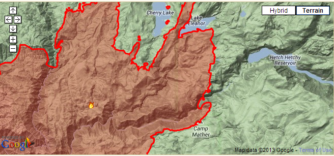
I was hoping this fire wouldn't make it to Camp Mather, but it looks like it has, from the last update on the
inciweb map.
Many good times were had there at the Strawberry Music Festival & backcountry debriefing.
The forest will be healthier for the fire over the long term, but I hope all of the firefighters and families in the area stay safe--any buildings lost can be rebuilt.
Many good times were had there at the Strawberry Music Festival & backcountry debriefing.
The forest will be healthier for the fire over the long term, but I hope all of the firefighters and families in the area stay safe--any buildings lost can be rebuilt.
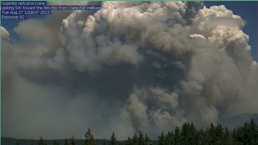
This is a link to a webcam located
at Crane Flat Helibase. It will load an image from this morning, but if you hit the "last" button, you can see how much the fire has expanded.
This one is a beast.
There are many other webcams available from the drop down menu, that give a good ideas of the spread of the fire and the air quality due to smoke.
This is the latest image from the Crane Flat cam:
This webpage will load all of the most recent images from the sierra webcams at once. Lots of smoke in many of them.
This one is a beast.
There are many other webcams available from the drop down menu, that give a good ideas of the spread of the fire and the air quality due to smoke.
This is the latest image from the Crane Flat cam:
edit on 8/25/2013 by Olivine because: add a pic
This webpage will load all of the most recent images from the sierra webcams at once. Lots of smoke in many of them.
edit on 8/25/2013 by Olivine because: add a link
reply to post by Olivine
You're right, this one is a beast! Thanks for the visuals link.
I want to correct what I said about the cause being lightning. Nothing official states that it is. There was a severe weather warning, but the fire might have started a little before any storm clouds came through. We'll just have to wait and see.
Olivine, this just sickens me. I know fire is a good thing, but the land will look like burnt charcoal for awhile. The trees dead. So long time to recover.
The reports are that the fire is spreading from tree crown to tree crown. Very bad news.
I live a very long distance from this fire, well over 200 miles, but happen to be downwind.
Our is quality is worse than Beijing on a bad day. We are even getting small ash particles here.
It's obviously bad. I wish everyone the best of luck. 125k acres.
Our is quality is worse than Beijing on a bad day. We are even getting small ash particles here.
It's obviously bad. I wish everyone the best of luck. 125k acres.
Originally posted by randomtangentsrme
reply to post by missvicky
I saw that this morning, I would agree at this point it is a large fire. I wouldn't agree that it's dangerous, except to those who are fighting it and those to stubborn to get away from it.
Perhaps my divide from the majority of posters on this thread, is that I have seen this countless times, and while never a victim myself, have had folks close to me lose possessions, or loved ones due to natural disasters, specifically fires.
They all moved on with their life. Some doing so multiple times. Yes it sucks people are going to lose their homes, but they will be rebuilt. They have time to remove any non replaceable items (photos, pets, etc). Plus as I mentioned earlier if the fire moves to developed areas it will be much easier to contain.
I think I realize the problem here...the OP said Statewide Ca Emergency which this fire will not create. So I do understand your seeming casualness about this fire regarding an emergency of that caliber. However this fire is still large, dangerous, and worthy of consideration. I, at least, would like to visit Yellowstone again in my lifetime without having to visit regrowth.
For updated info InciWeb is a great place. There is a map to show location of fires, which is
helpful, as now there is another one, the Fish Fire, in Sequoia National Forest (not Park), which could scare people as to location but the map shows
it is in backcountry, away from populated areas.
"Containment" means encirclement of the fire. That means establishing unburnable areas around the fire so it has no fuel in order to spread. At 15% there is still much more to go for 100%. I don't think the McNally fire was ever fully contained, just let burn into unpopulated areas.
I don't see how this is possible with the Rim Fire. If there is any vegetation in its path, it will want to burn. Usually fires can burn until they hit areas in the high country, alpine levels where vegetation becomes scarcer until finally trees don't grow. The rim fire is not close to the high country.
This Rim Fire is a crown fire, where the flames are like having a separate fire in the sky, above fire burning vegetation below. We need rain, but not more lightning. And, unfortunately, wind is stronger today. Seeing a fire like this is what the popular vision of Hell is.
reply to post by missvicky
Did you not realize the air quality that is hurting anyone with asthma and lung disease?
Did you not realize the air quality that is hurting anyone with asthma and lung disease?
The Rim Fire has increased to 179,481 acres in size, with 20% reported containment. inciweb Rim
Fire
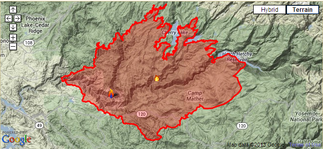
They are doing a good job holding the west side of the fire, but it has spread significantly on the SE edge, along Hetchhetchy reservoir, and toward the Tioga Rd (route 120).
This video is from the cockpit of a CA Air National Guard tanker, from the 22nd of August--scary fire.
Check out this twitter pic from the International Space Station on the 26th. Karen L Nyberg on the ISS
edit on 8/27/2013 by Olivine because:
add another link--it's what I do best, hehe
Lots of changing conditions in just 2 hours: from the
Crane Flat webcam.
At 10:06 am Pacific time:
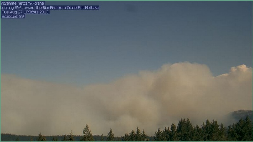
2 hours later:
You can check out the fire's spread into Yosemite Park boundaries on these satellite images from NASA:
At 10:06 am Pacific time:
2 hours later:
You can check out the fire's spread into Yosemite Park boundaries on these satellite images from NASA:
Agghhh! That's not what one wants to see in a forest.
Olivine, Groveland Facebook posters are saying that Mather is safe. In fact it had been used as a staging area. I hope it stays that way.
The White Wolf Yosemite area has been evacuated and closed. If 120 up there gets closed, that's too scary a thought for me; either there is concern of fire or the fire has burned too close.
There is no rain in the 10 day forecast, and winds will be NW. Very bad for that SE direction. But maybe there could be more of a chance for offensive action there, but would that call for more crews, etc? Bad, bad, bad.
I think lightning strike is pretty much being ruled out. Now, if human cause, was it accidental or intentional? Sometimes accidental is just as good as intentional, or even worse, as to the effects. I wouldn't be surprised if this was intentional.
And, yes, the smoke and ash has been bad in the surrounding areas. Not good for throats or lungs. Earlier this summer, a much smaller fire 70 miles away made air quality so bad, I knew there was a big fire somewhere, when my throat got sore for what seemed no reason.
stay safe. Please. If you haven't made "just in case" plans to get out of dodge, you might want to think about it. 15miles is not that far and
if this "rim fire" is only growing.... I'd be making those plans sooner than later.
Again, stay safe and best regards~
Again, stay safe and best regards~
Originally posted by TheLotLizard
reply to post by missvicky
Did you not realize the air quality that is hurting anyone with asthma and lung disease?
I said it is a dangerous fire.
I noticed that the fire was heading towards the Emigrant Wilderness area adjacent to Yosemite NP on the north The plan now to is to steer the fire
into that area so nature will help stop it. The plan is to starve the fire of fuel on the south (120) and north (108 it looks like) by burning in its
path (fighting fire with fire); and I wonder how long the retardant drops will continue?
The idea is to let the fire enter an area where it will find something it can't use as fuel, the granite areas of Emigrant. If you are lucky enough to fly over that area, perhaps coming into Fresno from the east, look down and you will see massive areas of granite. You wonder what happened to the forest, where did the trees go? You are actually looking at the exposed skeleton of the Sierra Nevada mountains. It is upon that granite, that the forests we love today eventually were built.
It will be in Emigrant where the Rim Fire finally dies I hope. Its death will not come soon, however. Hopefully, it will grow gaunt from lack of food, but maybe it will only take its last gasp when rain or snow pounds it from above. It might be that this year, when patrons join the snow pool, they will also be joining a pool to see when the Rim Fire burns out. The Mcnally fire went on for 37 days.
Well, on a lighter note, I keep seeing photos of cows walking in burned out forest or near firefighters. No, this is not how we barbeque our beef here!
reply to post by sulaw
You are so correct. (And thanks for your concern. My interest in the fire came from having a friend in that area.)
When asked about how long someone has before they have to leave after a LEO knocks on their door and says to evacuate now, the sheriff replied, "If you're ready, you don't have to get ready!" I liked that!
new topics
-
Biden-Harris Admin Reportedly Preparing to Resume Migrant Flight Program Plagued with Fraud
US Political Madness: 40 minutes ago -
National Grid Wants to Install a “Smart Meter”
General Conspiracies: 1 hours ago -
Massachusetts GOP accuses governor of secret $1 billion migrant spending spree
US Political Madness: 10 hours ago -
Anniversary of Abbey Gate Bombing Gold Star Families Say They've Never Heard From Biden or Harris
Politicians & People: 10 hours ago -
The Naivety of a President Kamala Harris Will Destroy Your Finances - You Are Being Warned.
2024 Elections: 10 hours ago
top topics
-
The Naivety of a President Kamala Harris Will Destroy Your Finances - You Are Being Warned.
2024 Elections: 10 hours ago, 9 flags -
Anniversary of Abbey Gate Bombing Gold Star Families Say They've Never Heard From Biden or Harris
Politicians & People: 10 hours ago, 7 flags -
New election ad from The Lincoln Project
2024 Elections: 14 hours ago, 6 flags -
10 Questions Leaked From CNN's Harris/Walz Interview from the Babylon Bee
Politicians & People: 14 hours ago, 6 flags -
Massachusetts GOP accuses governor of secret $1 billion migrant spending spree
US Political Madness: 10 hours ago, 6 flags -
National Grid Wants to Install a “Smart Meter”
General Conspiracies: 1 hours ago, 2 flags -
Biden-Harris Admin Reportedly Preparing to Resume Migrant Flight Program Plagued with Fraud
US Political Madness: 40 minutes ago, 1 flags
active topics
-
New Series on the Discovery Channel - Alien Encounters: Fact or Fiction
Aliens and UFOs • 21 • : Ophiuchus1 -
Biden-Harris Admin Reportedly Preparing to Resume Migrant Flight Program Plagued with Fraud
US Political Madness • 2 • : SteamyAmerican -
Anniversary of Abbey Gate Bombing Gold Star Families Say They've Never Heard From Biden or Harris
Politicians & People • 10 • : SteamyAmerican -
Harris campaign rejects Trump claim on agreement over hot mics for Sept. 10 debate
US Political Madness • 26 • : WeMustCare -
WHY are Harris and Biden Campaigns Paying Kamala's Husband's Ex?
US Political Madness • 49 • : CarlLaFong -
National Grid Wants to Install a “Smart Meter”
General Conspiracies • 7 • : AdultMaleHumanUK -
10 Questions Leaked From CNN's Harris/Walz Interview from the Babylon Bee
Politicians & People • 10 • : Coelacanth55 -
Cannabis Revealed to Have Anti-Aging Effect in The Brains of Mice
Science & Technology • 38 • : chiefsmom -
Eighty thousand deserters in Ukraine
World War Three • 199 • : Oldcarpy2 -
They came hoping for Beyonce. They left with Covid
Diseases and Pandemics • 47 • : Owlwatcher