It looks like you're using an Ad Blocker.
Please white-list or disable AboveTopSecret.com in your ad-blocking tool.
Thank you.
Some features of ATS will be disabled while you continue to use an ad-blocker.

What is going on in the Sonoran Desert?
page: 1share:
About a year ago I stumbled upon a video that showed a few odd things scattered around the southern Arizona desert, but I can't seem to locate it.
However, I did find a link I had saved on google maps by doing some research of my own, and I thought I would share my findings with everyone. Now I am not sure if this is even the appropriate place to make this topic, but seeing as this area is associated with high UFO activity, and with the rest of the mysteries of the desert and what the military is up to out there, I figured I'd post here. Please keep in mind that I could not find any information about this stuff on the web, so forgive me if this is old news. Honestly I would not be surprised if it was, because it didn't take much effort to find weird stuff in the desert.
I am really hoping some of you can explain what some of this stuff is, because I haven't a clue. Also please keep in mind that I am not in any way implying that all or any of this is connected with ETs or UFOs, in fact a lot of this stuff seems to be military,at least it SEEMS that way, I don't know, hopefully some of you do. That is not to say that there are a few intriguing things that made me think about a connection. Namely the mysterious mountains, and the weird bright light. I'd REALLY like to know what those are in particular.
Just take a look for yourselves, just go down the list and it will walk you through it. Make sure to read the little notes for most of the thumbnails. Who knows what else is out there, there could be more, or not, this is just what I found. Maybe you can find more. I recommend using Google Earth to look around.
Good luck and I hope some of you have answers. Link below.
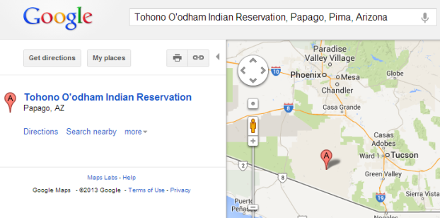
Arizona Desert
However, I did find a link I had saved on google maps by doing some research of my own, and I thought I would share my findings with everyone. Now I am not sure if this is even the appropriate place to make this topic, but seeing as this area is associated with high UFO activity, and with the rest of the mysteries of the desert and what the military is up to out there, I figured I'd post here. Please keep in mind that I could not find any information about this stuff on the web, so forgive me if this is old news. Honestly I would not be surprised if it was, because it didn't take much effort to find weird stuff in the desert.
I am really hoping some of you can explain what some of this stuff is, because I haven't a clue. Also please keep in mind that I am not in any way implying that all or any of this is connected with ETs or UFOs, in fact a lot of this stuff seems to be military,at least it SEEMS that way, I don't know, hopefully some of you do. That is not to say that there are a few intriguing things that made me think about a connection. Namely the mysterious mountains, and the weird bright light. I'd REALLY like to know what those are in particular.
Just take a look for yourselves, just go down the list and it will walk you through it. Make sure to read the little notes for most of the thumbnails. Who knows what else is out there, there could be more, or not, this is just what I found. Maybe you can find more. I recommend using Google Earth to look around.
Good luck and I hope some of you have answers. Link below.
Arizona Desert
edit on 16-8-2013 by roncoallstar because: missing information
reply to post by roncoallstar
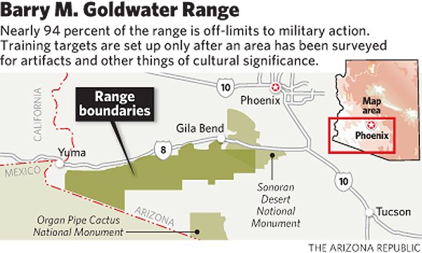
Perhaps it has something to do with the military and this ...
Army weapons base seeks more Arizona desert land
Perhaps it has something to do with the military and this ...
Army weapons base seeks more Arizona desert land
Just west of the reservation is the Barry M. Goldwater Bombing Range:
edit on 8/16/2013 by this_is_who_we_are because: typo
Could it be something to do with this new building, a massive solar power tower. Work started last year.
www.newser.com...
www.newser.com...
reply to post by roncoallstar
Looks like a military training area. Its incredible how you find these things, you must spend hours on GE.
Looks like a military training area. Its incredible how you find these things, you must spend hours on GE.
Originally posted by smurfy
Could it be something to do with this new building, a massive solar power tower. Work started last year.
www.newser.com...
What a dumb place to put that tower. 750 million bucks in an area where the sand can sandblast it in one big sandstorm Who oversees these ventures, talk about making risky investments.
Originally posted by rickymouse
Originally posted by smurfy
Could it be something to do with this new building, a massive solar power tower. Work started last year.
www.newser.com...
What a dumb place to put that tower. 750 million bucks in an area where the sand can sandblast it in one big sandstorm Who oversees these ventures, talk about making risky investments.
Perhaps, but there is more on it here,
www.abc15.com...
It will be 2,600ft high, has a dual power system, both derived indirectly from the sun's heat, so not a solar panel set-up, although the artist's impression appears to show solar panels on the ground.
Originally posted by this_is_who_we_are
Just west of the reservation is the Barry M. Goldwater Bombing Range:
edit on 8/16/2013 by this_is_who_we_are because: typo
More info -
www.globalsecurity.org...
Also in the area is the famous Kitt Peak Observatory -
nsokp.nso.edu...
Good eyes - but I'm still befuddled about the bright light. I first thought of a livestock cistern, which is like an inverted metal roof with a collecting tank usually buried in the ground at one end, but your light is way too reflective to be coming from a bunch of old galvani\zed metal.
Originally posted by this_is_who_we_are
Just west of the reservation is the Barry M. Goldwater Bombing Range:
edit on 8/16/2013 by this_is_who_we_are because: typo
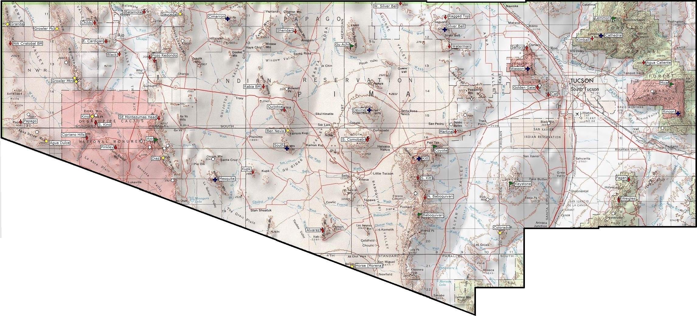
Just west of the reservation, yes. But if you look at that map, the points I have indicated are ON the actual reservation. Unless that expansion extended onto the reservation, I just don't understand why this stuff is here and why they are bombing indian land if this is in fact on the reservation.
Thanks for the replies people, how about those circles littered around the east Sonoran Desert? Anyone have an idea what these are?
reply to post by roncoallstar
I-19 runs right through an Indian Reservation, and yes the military leases land from tribes to use as training areas. This happens in Alaska as well.
I-19 runs right through an Indian Reservation, and yes the military leases land from tribes to use as training areas. This happens in Alaska as well.
Originally posted by gortex
reply to post by roncoallstar
Perhaps it has something to do with the military and this ...
Army weapons base seeks more Arizona desert land
Perhaps, but not likely according to that article. It claims that the expansion will extend from I-8 to I-10, so this doesn't explain any of the POI's I have pointed out. Cleary every POI is south of the I-8 and I-10 grid.
I cannot find any more information about further expansion.
reply to post by roncoallstar
A bulk of those marks are on the Tohono O'Odham reservation, so quite possible some of those "circles" were used by the inhabitants there for ceremonies. Once the temps get below 100 out there this time of day I can drive over and photograph one.
A bulk of those marks are on the Tohono O'Odham reservation, so quite possible some of those "circles" were used by the inhabitants there for ceremonies. Once the temps get below 100 out there this time of day I can drive over and photograph one.
reply to post by gavron
Wow, that would be absolutely awesome if you could do that sometime. It is very odd how there are no trees anywhere around them, but there is a circle of trees surrounding the circles, like they were planted there. to conceal the circle...but then again if they are natural reservoirs with water, trees around it might make sense.
Also, there are actually a few of those circles that look like they could possibly be a hole underground, as the images show a black hole. Circles #3,#4,and #5. Holes? Water? What do you think? One more thing I just noticed, on hole #4, on the south edge there seems to be some structures inside.
edit on 18-8-2013 by roncoallstar because: (no reason given)
I'll toss my $0.02 in on some of these:
Star Circle 1 is probably a simulated SA-2 Guideline SAM site.
Compare with this image of a Guideline emplacement taken during the Cuban Missile Crisis.
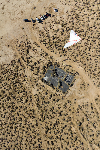
The Airport is probably a mock-up 'enemy air base' for pilot training...note the the aircraft sitting on the runway has no tail assembly, and its wings are broken.
Star Circle 2 is probably another simulated SAM site. The star configuration comes from having the launchers in a circle, with command and guidance vehicles in the middle, and paths connecting all of the launchers.
The Airport and Bunkers looks like another simulated air base with a couple of aircraft sitting in revetments. I can't swear to it, but it *looks* like the two aircraft on the left lack vertical tails...maybe scrapped out Convair F106s?
Bombing Range? I'd bet a round of drinks on that being the right call.
The sets of concentric circles are almost certainly bombing targets
The 'buildings' might be storage / shipping containers set up as stand-ins for real buildings as part of a bombing range.
The other things I can't help you with.
Star Circle 1 is probably a simulated SA-2 Guideline SAM site.
Compare with this image of a Guideline emplacement taken during the Cuban Missile Crisis.
The Airport is probably a mock-up 'enemy air base' for pilot training...note the the aircraft sitting on the runway has no tail assembly, and its wings are broken.
Star Circle 2 is probably another simulated SAM site. The star configuration comes from having the launchers in a circle, with command and guidance vehicles in the middle, and paths connecting all of the launchers.
The Airport and Bunkers looks like another simulated air base with a couple of aircraft sitting in revetments. I can't swear to it, but it *looks* like the two aircraft on the left lack vertical tails...maybe scrapped out Convair F106s?
Bombing Range? I'd bet a round of drinks on that being the right call.
The sets of concentric circles are almost certainly bombing targets
The 'buildings' might be storage / shipping containers set up as stand-ins for real buildings as part of a bombing range.
The other things I can't help you with.
Originally posted by roncoallstar
reply to post by gavron
Wow, that would be absolutely awesome if you could do that sometime. It is very odd how there are no trees anywhere around them, but there is a circle of trees surrounding the circles, like they were planted there. to conceal the circle...but then again if they are natural reservoirs with water, trees around it might make sense.
Also, there are actually a few of those circles that look like they could possibly be a hole underground, as the images show a black hole. Circles #3,#4,and #5. Holes? Water? What do you think? One more thing I just noticed, on hole #4, on the south edge there seems to be some structures inside.edit on 18-8-2013 by roncoallstar because: (no reason given)
I don't know what those particular circles *are*, as I noted (or at least implied) in my reply to the OP. I will say that if the USAF was trying to conceal something in a desert, planting stands of trees around it is just about the stupidest method I can imagine. Those trees stick out in the desert like the only hippie in USMC boot camp! :-D
I'd bet (based on the dark color and the plant growth around them) that those particular circles are water-filled, as opposed to being holes, but I have no Earthly idea what they're for. My first thought was waste treatment settlement ponds, but there seem to be too many of them, and the locations are awfully remote.
This is very strange! Those arrows are almost pointing to the think in the middle? So strange this is my state, I wonder if I went ther how much
trouble I would get into?
Wouldnt go with nothing less then 10 gals of water though
Wouldnt go with nothing less then 10 gals of water though
reply to post by Brother Stormhammer
Yep - I'll agree with this assessment. having done lots of aerial photogrammetry work and being veteran airborne, I can almost surely bet that most of these are aerial targeting features, nothing more. The desert, particularly in the American southwest is loaded with them. They're all over the place. The Desert is good for this as it has few other distracting surface features. There's nothing sinister, conspiratorial, or "spooky" about them.
Trust me: if the military or gubbmint wanted to hide things from civilian eyes, especially knowing that every armchair gumshoe has Google Earth on their desktops, lots of time, and vivid imaginations - they could (and do) easily do it.
Nobody does camo better than the grunts, flyboys, and jarheads of the US military. This ain't it.
Heres' a few more to go ga-ga over:


Before and after...

e.g., (and don't tell anyone where you saw this [heh-heh]...


Yep - I'll agree with this assessment. having done lots of aerial photogrammetry work and being veteran airborne, I can almost surely bet that most of these are aerial targeting features, nothing more. The desert, particularly in the American southwest is loaded with them. They're all over the place. The Desert is good for this as it has few other distracting surface features. There's nothing sinister, conspiratorial, or "spooky" about them.
Trust me: if the military or gubbmint wanted to hide things from civilian eyes, especially knowing that every armchair gumshoe has Google Earth on their desktops, lots of time, and vivid imaginations - they could (and do) easily do it.
Nobody does camo better than the grunts, flyboys, and jarheads of the US military. This ain't it.
Heres' a few more to go ga-ga over:
Before and after...

e.g., (and don't tell anyone where you saw this [heh-heh]...
Thank you Outrageo and Brother Stormhammer for those detailed replies.
It was fairly obvious there are military, the problem I have with it is the location. Right smack in the middle of the reservation.
As for the circles, if they actually hold meaning, would military really leave them exposed? True the circles of trees would stand out like a sore thumb, but they are literally in the middle of nowhere, so not many eyes see it anyway, if any.
Not saying they are actually anything, in fact I am leaning towards some type of reservoir, but who knows.
new topics
-
Bibi’s Dilemma
Middle East Issues: 1 hours ago -
Proof of Cleptocracy
US Political Madness: 5 hours ago -
Boy Scouts to be renamed next year
Other Current Events: 9 hours ago -
Pfizer agrees to settle over 10,000 Zantac lawsuits after cancer causing substance found in drug
Medical Issues & Conspiracies: 9 hours ago
top topics
-
Ooooh...it worked!!
Members: 17 hours ago, 20 flags -
Judas Iscariot Slips The Hangman's Noose
Political Issues: 12 hours ago, 10 flags -
Pfizer agrees to settle over 10,000 Zantac lawsuits after cancer causing substance found in drug
Medical Issues & Conspiracies: 9 hours ago, 5 flags -
Proof of Cleptocracy
US Political Madness: 5 hours ago, 5 flags -
Bibi’s Dilemma
Middle East Issues: 1 hours ago, 5 flags -
A Shout-out To truthseeker45 Hoot Hoot
General Chit Chat: 14 hours ago, 4 flags -
Murder Suicide Investigation Still Active 4 months later?
Other Current Events: 13 hours ago, 4 flags -
Boy Scouts to be renamed next year
Other Current Events: 9 hours ago, 4 flags
active topics
-
Boy Scouts to be renamed next year
Other Current Events • 76 • : Dandandat3 -
The Dark Pyramid of Alaska and the Why Files take on the subject
Whistle Blowers and Leaked Documents • 28 • : 320MPH -
New York Governor Hochul Assures Business Owners that ONLY Donald Trump is being Targeted.
General Conspiracies • 95 • : WeMustCare -
Candidate TRUMP Now Has Crazy Judge JUAN MERCHAN After Him - The Stormy Daniels Hush-Money Case.
Political Conspiracies • 1416 • : WeMustCare -
NYAG Letitia James Prepares to Begin Seizing TRUMP Assets Even Though There Was No Crime.
Above Politics • 287 • : WeMustCare -
New House GOP Bill To Send Pro Hamas College Law Breakers to Gaza for 6 Months
Social Issues and Civil Unrest • 91 • : mechtech87 -
My dog is weird
Pets • 27 • : FlyersFan -
Judge Postpones Trump Classified Docs Trial INDEFINITELY
US Political Madness • 154 • : WeMustCare -
Archiving selected UFO threads from ATS as PDF files
Aliens and UFOs • 44 • : IsaacKoi -
-@TH3WH17ERABB17- -Q- ---TIME TO SHOW THE WORLD--- -Part- --44--
Dissecting Disinformation • 885 • : IndieA