It looks like you're using an Ad Blocker.
Please white-list or disable AboveTopSecret.com in your ad-blocking tool.
Thank you.
Some features of ATS will be disabled while you continue to use an ad-blocker.

Map of Pangea
page: 1share:
I couldn't choose the appropriate forum so mods if this doesn't suit, please sort it out
Now, I know this isn't anything new, but personally for me this is by far the best picture of Pangea - So I thought I'd share with ATS
Here the map created by Massimo Pietrobon;
Link to full image
Now, I know this isn't anything new, but personally for me this is by far the best picture of Pangea - So I thought I'd share with ATS
Wiki
Pangea was a supercontinent that existed during the late Paleozoic and early Mesozoic eras, forming about 300 million years ago. It began to break apart around 200 million years ago
Here the map created by Massimo Pietrobon;

Link to full image
reply to post by n00bUK
I always like looking at projections of how the Earth looked in the past, and future projections as well, just any maps really.
Cool stuff.
A map of the world as it might appear 250 mil. yrs. from now.
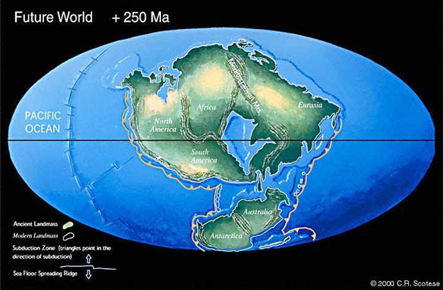
Source
I like the country borders in yours, pretty cool.
I always like looking at projections of how the Earth looked in the past, and future projections as well, just any maps really.
Cool stuff.
A map of the world as it might appear 250 mil. yrs. from now.
Source
I like the country borders in yours, pretty cool.
I'm giving aS&F because I like things like this, but my hearts a little broken.
When I saw the forum I assumed an ancient map...
When I saw the forum I assumed an ancient map...
i know its logical to look at it like that
but i still think its wrong
best way...i think...is to firstly remove the water... then look at it
here
www.celestiamotherlode.net...
but i still think its wrong
best way...i think...is to firstly remove the water... then look at it
here
www.celestiamotherlode.net...
edit on 1-6-2013 by thePharaoh because: (no reason given)
reply to post by thePharaoh
I agree. Looking at it with the water gives the impression that there is very little land mass, but it's all land under the water.
Mind you, without the water there would have been much less definition, so it's also misleading.
Ahh to be able to shoot up into the upper atmosphere and go back in time... how astonishing it would be to see the Earth forming..

Looking at that map, I notice how far apart india and China once were. Could that truly have been?
I don't know if it would be possible to REALLY include every country because I thought that over time, some areas would go underwater and some would emerge out of the water... Though I did notice not all countries were the same size... Also, where's Atlantis? XD
I don't know if it would be possible to REALLY include every country because I thought that over time, some areas would go underwater and some would emerge out of the water... Though I did notice not all countries were the same size... Also, where's Atlantis? XD
Originally posted by 3n19m470
Looking at that map, I notice how far apart india and China once were. Could that truly have been?
In theory, that's the reason for the Himalayas.
India goes crashing into the south of China at great speed, geologically speaking, and the mountains get pushed up.
edit on 2-6-2013 by DISRAELI because: (no reason given)
Excuse me for asking this question cuz I'm no expert , was earth smaller back then ? I mean separating those plates from each other would need a huge
expansion , am I right ?
It makes more sense to me the earth would be expanding than just land floating away.
Could someone take the time to map out all known pyramids and see what we end up with? Other interesting ancient structures with questionable
origins/ages?
reply to post by n00bUK
Thank you for posting this.
I love that map of Pangaea that you shared with us.
[By the way, I think you might have misspelled Pangaea in your title.]
Anyway, it reminds me of the "Expanding Earth Theory":
At first, I could not believe the "Expanding Earth Theory", but the more I looked into it, the more it began to make sense. At this point in time, I am a firm believer.
Basically, the earth, the sun, and any other planet (or star), is a node in space that traps and accumulate physical particles. These particles may perhaps even come from other dimensions.
As we know, in the vacuum of space, there constantly is particles that come into existence, and particles that fall out of existence at the same rate, so that the net effect is the vacuum of space.
This is different in the case of planets and stars. Every planet and star is a concentrated node of physical particles. When a particle comes into existence inside a planet or a star, it stays trapped in our 3D space, and cannot fall out of existence again. The gravity of the surrounding mass keeps it trapped in our 3D space.
That is the reason why planets and stars grow.
And that is the reason why our continents today, can still fit together to form Pangaea.
Cheers
QMask
Looking at the map you posted makes me wonder something...what lies outside the "Pillars of Hercules" as the land masses were originally? If there
was tribal memory of a place handed down for thousands of years, is it possible that the place mentioned as existing outside the pillars might now be
in a totally different location?
Originally posted by Glipski
Looking at the map you posted makes me wonder something...what lies outside the "Pillars of Hercules" as the land masses were originally? If there was tribal memory of a place handed down for thousands of years, is it possible that the place mentioned as existing outside the pillars might now be in a totally different location?
An interesting thought as Pangea is presented in the image above showing that the outside of the Pillars of Hercules would be Newfoundland - and some 300 million years ago........somewhat putting your theory in jeopardy
It is amazing that the continents made it to their present locations and shapes in less than 6,000 years! WoW
Originally posted by Dr UAE
Excuse me for asking this question cuz I'm no expert , was earth smaller back then ? I mean separating those plates from each other would need a huge expansion , am I right ?
YES, ther is a very good chance that Earth has been growing in size so plate tectonics is only a Stupid way to explain the movement of land masses.
Google Earth grows there are some nice videos on youtube.
All land masses interlock so its quite possible the planet is growing.
Originally posted by Glipski
Looking at the map you posted makes me wonder something...what lies outside the "Pillars of Hercules" as the land masses were originally? If there was tribal memory of a place handed down for thousands of years, is it possible that the place mentioned as existing outside the pillars might now be in a totally different location?
that would be between Spain and Africa? if so then it looks like Newfoundland.
hmm how much of the interior of dear old newfy has been thoroughly explored? it seems that just about everyone lives on the coast with the interior being pretty much uninhabited.
Centrifugal force forces the plates apart to their current position.
Previously there had to be a large 'weight of land' on the other side of the world to balance the world...much like a top.
The 'weight mass' on the other side may have been sheared off in a collision with another planetary object, which made what we now call our moon.
Yes, I know, I always have opinions that contradict the printed word. One day someone will start a thread about how petroleum is formed and I will get on my soap box again. Petroleum is still being formed today.
Thats really interesting,our earth has moved around & changed so much,in a few million years it'll look totally different to what it looks like
now.
i'd love to be able to see what it was like,but my time machine is out of action at the moment though
S+F
i'd love to be able to see what it was like,but my time machine is out of action at the moment though
S+F
reply to post by n00bUK
Nice map, but the less schooled among us may think that the Great Lakes in the U.S. (and other lakes and rivers) were a carryover from Pangea. So just to make clear, no, they weren't. But then again, Lake Erie was always a bit fishy (hahahahahaha).
Nice map, but the less schooled among us may think that the Great Lakes in the U.S. (and other lakes and rivers) were a carryover from Pangea. So just to make clear, no, they weren't. But then again, Lake Erie was always a bit fishy (hahahahahaha).
new topics
-
Richard Tandy ELO R.I.P.
Music: 1 hours ago -
ICJ Did NOT Find There Was a Plausible Case That Israel Is Committing Genocide
World War Three: 3 hours ago -
The Pentagon is lying about UFOs
Aliens and UFOs: 3 hours ago -
Israel's plans for the West
Above Politics: 3 hours ago -
Who I am is me.
Introductions: 6 hours ago -
White House considers welcoming some Palestinians from war-torn Gaza as refugees
US Political Madness: 7 hours ago
top topics
-
There Are No Adult Leftists
US Political Madness: 13 hours ago, 19 flags -
White House considers welcoming some Palestinians from war-torn Gaza as refugees
US Political Madness: 7 hours ago, 9 flags -
ICJ Did NOT Find There Was a Plausible Case That Israel Is Committing Genocide
World War Three: 3 hours ago, 4 flags -
The Pentagon is lying about UFOs
Aliens and UFOs: 3 hours ago, 3 flags -
Who I am is me.
Introductions: 6 hours ago, 2 flags -
Israel's plans for the West
Above Politics: 3 hours ago, 2 flags -
Richard Tandy ELO R.I.P.
Music: 1 hours ago, 1 flags
active topics
-
There Are No Adult Leftists
US Political Madness • 52 • : chr0naut -
Candidate TRUMP Now Has Crazy Judge JUAN MERCHAN After Him - The Stormy Daniels Hush-Money Case.
Political Conspiracies • 940 • : Dandandat3 -
ICJ Did NOT Find There Was a Plausible Case That Israel Is Committing Genocide
World War Three • 14 • : Lazy88 -
The Acronym Game .. Pt.3
General Chit Chat • 7777 • : RAY1990 -
Numerous officers hurt in active east Charlotte shooting
Breaking Alternative News • 42 • : VariedcodeSole -
Can we turn on the water fountains, America?
Social Issues and Civil Unrest • 18 • : Zanti Misfit -
Introduction of Albone
Introductions • 6 • : BingoMcGoof -
Hard evidence of a Royal plot on the US....if only i had proof.
ATS Skunk Works • 80 • : Solvedit -
White House considers welcoming some Palestinians from war-torn Gaza as refugees
US Political Madness • 23 • : DBCowboy -
Israel rejected early Hamas offer to free all civilians if IDF didn’t enter Gaza
Middle East Issues • 113 • : FlyersFan