It looks like you're using an Ad Blocker.
Please white-list or disable AboveTopSecret.com in your ad-blocking tool.
Thank you.
Some features of ATS will be disabled while you continue to use an ad-blocker.

Athanasius Kircher's ATLANTIS map meets Google Earth
page: 2share:
reply to post by spiritualarchitect
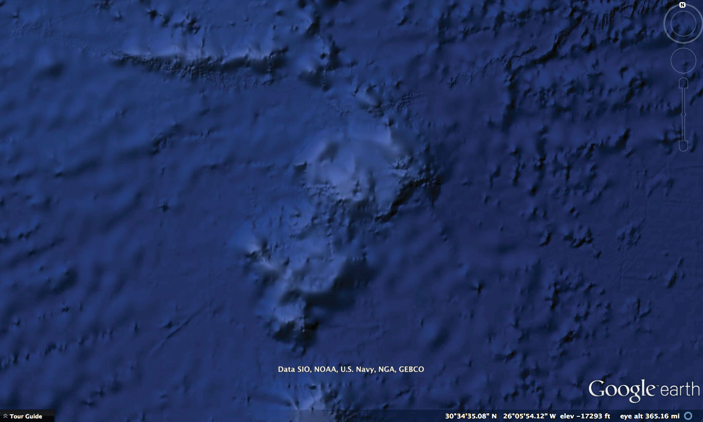
But wait it gets better!
My artist's eye immediately noticed those aren't "circles" in the island to the north...
They are Fibonacci Spirals:
google earth
spiral1
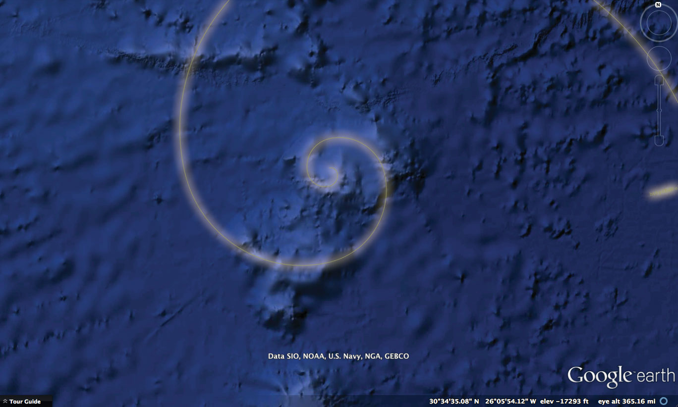
spiral 2
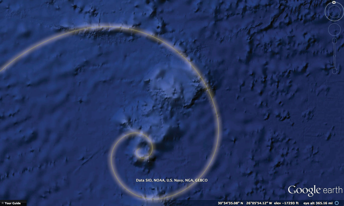
both:
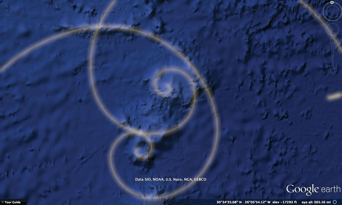
Download or create a fibronacci spiral and you will see there are many here.
So is this some random creation of nature? Or evidence of manipulation on a grand scale?
But wait it gets better!
My artist's eye immediately noticed those aren't "circles" in the island to the north...
They are Fibonacci Spirals:
google earth
spiral1
spiral 2
both:
Download or create a fibronacci spiral and you will see there are many here.
So is this some random creation of nature? Or evidence of manipulation on a grand scale?
edit on 18-4-2013 by pianopraze because: added 1st image to orient location
Originally posted by On7a7higher7plane
reply to post by spiritualarchitect
Anyone ever think Atlantis may have been located near (or in) Indonesia?
Plate tectonics and volcanic eruptions could have led to drastic geological changes in the area over a relatively short period of time.
It would make sense for such a legendary nations ruins to hide in such plain sight. And the size of Indonesia is appropriate. Look at the elevation charts for the Indonesia area and it starts to make a lot of sense.edit on 18-4-2013 by On7a7higher7plane because: addition
No because Atlantis was beyond the pillars of Heracles, that's the closest point between Africa and Europe see maps, but if you said Lemuria then it was out in the Pacific or Indian ocean then yeah why not.
yonaguni extreme southern japan or it could be any sunken city off the coast of India
Personally I believe Atlantis is compounded confused mixture of geographic areas the ancients put together,Thera, which the ancient Egyptians were familiar when the volcano blew it affected both the north and south med, and much of it sanked below the waves.
The Therans were also a sea going folk highly civilized the Egyptians could have linked both civilizations as some distant memory of contacts with Meso-America... see evidence for contacts coc aine and tobacco mummies
Originally posted by Blue Shift
Or perhaps something more like this, with lower water levels.

Quick question. How much did the oceans rise after the last ice age?
a) We know that before the last ice age ended britian was effectively connected to the european mainland.
b) We also know that in north america a vast amount of water rushed into the oceans after the glaciers melted.
Just a theory but what if atlantis was above water during the last ice age. Once the ice dams broke a tsunami of water destroyed any and all civilizations that lived on these islands. This would explain the story of atlantis getting wiped out in one day.
reply to post by QuietSpeech
Thank you for your reply. The two guys who made the videos did all the real work. Once I found one of the videos I put weeks into watching them on a big screen and reading up on the map. I only put a few days into getting this thread together. ATS deleted one of the links I put in because it went to another site. But you can still get the jest of what is being shown. Most of the Google Maps attention was drawn to a grid which lay just east of this arrowhead. It was removed from Google Maps because of the uproar. The reason they gave was something like it being only sonar lines and not actual features.
Though I had looked at pictures of the ocean floor before, I never matched the map to the mesa, probably because the map looks so big and is upside down. But all the credit goes to the two guys who made the videos ~ Search4atlantis and Danny Whilten.
I sent Danny an e mail but never heard from him. I sent Hancock and Shock and half a dozen other "experts" e mails too but never heard back from them. They probaly all went to spam.
reply to post by Malynn
Yes, I know who you are talking about. I actually put this thread on Amazon first and most people there refused to comment on it. Probably because it causes rewriting history, and we don't want that now do we.
Yes, I know who you are talking about. I actually put this thread on Amazon first and most people there refused to comment on it. Probably because it causes rewriting history, and we don't want that now do we.
reply to post by azureskys
I believe THIS is what the other poster is referring to.
Obviously there is a lot of debate about the credibility of the photos and evidence.
Considering I do not personally know anyone involved with the research and have only seen/heard what has been presented to me via this magical screen...my opinion is still out to lunch.
edit on 18-4-2013 by eleven44 because: (no reason given)
reply to post by problemsolvr
I looked at the ATS threads on South American Atlantis and it does match well. Except it is in the wrong spot in relation to Spain. And South America does not have two islands sitting on its west side like the arrowhead mesa does. But this thread is about the underwater mesa matching the map. How can that be unless it was above water at one time?
I looked at the ATS threads on South American Atlantis and it does match well. Except it is in the wrong spot in relation to Spain. And South America does not have two islands sitting on its west side like the arrowhead mesa does. But this thread is about the underwater mesa matching the map. How can that be unless it was above water at one time?
reply to post by Tahnya86
But your post side steps the question of why there is an underwater feature that has been mapped in ancient times and labeled Atlantis, right where Plato said it was.
But your post side steps the question of why there is an underwater feature that has been mapped in ancient times and labeled Atlantis, right where Plato said it was.
reply to post by eleven44
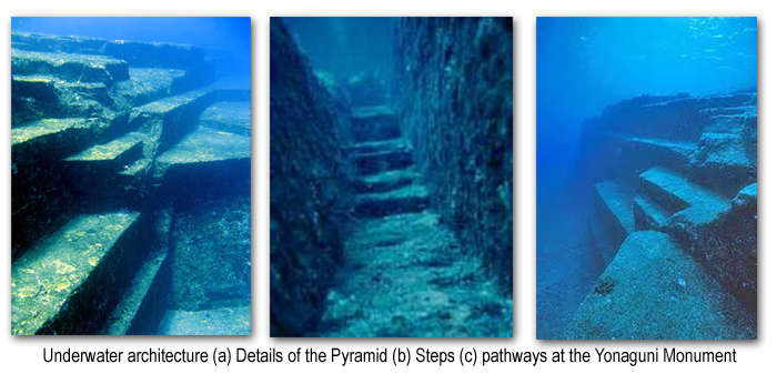
The glass pyramids. I think the first comment under picture says it all. If they are real, why are these photos not EVERYWHERE? Why is this not a known fact around the world?
The glass pyramids. I think the first comment under picture says it all. If they are real, why are these photos not EVERYWHERE? Why is this not a known fact around the world?
The question still stands. Regardless of degrees or pyramids or crystals or Noah or anything else, this underwater mesa looks like what was drawn on
an ancient map. How does one get around that?
reply to post by Hazon
The Egyptian priest said Atlantis was right outside the entrance to the Pillars of Heracles.
For Atlantis to be Greenland, like Antarctica, we are talking about earth crust displacement. Which of course could be a perfect reason for a land mass to be sunk. But Greenland and Antarctica are not sunk. They are above the water.
reply to post by spiritualarchitect
I don't know.
Why isn't the fact that 9/11 is an inside job accurately being discussed in main stream sources? How come the MAJORITY of major events happening around the world aren't being discussed in mainstream sources??
Come on, now. You're on ATS and you're using the 'if it's not on the MSM then it's not real' argument?
Again, i'm not saying these ARE true. I honestly don't know and I wouldn't be surprised either way. But it's a weak argument just to say that the lack of mainstream sources means that it didn't happen.
I'm doing a bit of research on this myself, and I have found the following: The area in question is called the Great Meteor Seamount, named for a
German research vessel named Meteor in the late 1930's. The geographical feature is something called a Guyot, which the Wikipedia article
describes thus: "Guyots show evidence of having been above the surface with gradual subsidence through stages from fringed reefed mountain, coral
atoll, and finally a flat topped submerged mountain". So there is a very good possibility that this was once above sea level. Interestingly enough,
the whole area is referred to as the Atlantis-Meteor Seamount Complex. It is also only 500 meters down.
edit on 18-4-2013 by Vonotar because:
More information.
reply to post by spiritualarchitect
All I'm saying is that when I saw that image the first thing that came to mind is "hmm, that reminds me of Greenland."
All I'm saying is that when I saw that image the first thing that came to mind is "hmm, that reminds me of Greenland."
Ya know.. people need to consider that there could be --> more than one Atlantis.
We know of Plato's Atlantis but who is to say this was just one island where these people settled. Look at the world today - Every nation always seeks to gain more ground and expand it's influence. It seems to me the Atlantians would have done the same. This means the technology they used would wind up being found in many other places around the globe. Or not, because it evolved over the years as did the people, who are now known as ancient residents of modern lands.
Your great great great great ect. grandfather could be an Atlantian. I think this map and the Google Earth correlation is interesting. I think we need to investigate these places and bring back to study all artifacts found. This information should be free to all the worlds citizens and not controlled by any governments. That's the only way we will make real progress.
So the question is: if this landmass was above water 12,000 years ago, did it have a bronze age civilisation, identical to that which the
Mediterranean had 8,000 years later? And did Athens also have a bronze age civilisation, identical to how it would 8,000 years later? And did the
later defeat the former in war? eaving no archaelogical evidence whatsoever, with a subsequent reversion to hunter/gather lifestyles?
Otherwise, Plato's tale is nothing but a tale.
As for Greenland, I think 2 miles of ice for the past million years (the ice cap was admittedly less extensive than today during some interglacials, such as the Eemian 125,000 years ago) rather puts paid to that? Or are we now invoking bronze age civilisations on Greenland and in Egypt and Greece 125,000 years ago?
Oh, and btw, why did Atlantis invade the Mediterranean when there were obvious, empty, fertile, landmasses closer to hand?
edit on 18-4-2013 by
AndyMayhew because: (no reason given)
reply to post by eleven44
If 9/11 is an inside job, POLITICS would be the reason we are not hearing about it.
I would like the glass pyramids to be real. How cool would that be!
Like Fictitious said, Where is James Cameron when you need him?
If 9/11 is an inside job, POLITICS would be the reason we are not hearing about it.
I would like the glass pyramids to be real. How cool would that be!
Like Fictitious said, Where is James Cameron when you need him?
reply to post by Vonotar
Excellent work Vonotar! 500 meters is only 1,640 feet. According to Graham Hancock’s web site, the one I was not allowed to link to, the top point of land there is only 73 feet deep. That must mean that the mountain top, the one which the video is claiming could be buildings, is only 73 feet down.
Excellent work Vonotar! 500 meters is only 1,640 feet. According to Graham Hancock’s web site, the one I was not allowed to link to, the top point of land there is only 73 feet deep. That must mean that the mountain top, the one which the video is claiming could be buildings, is only 73 feet down.
reply to post by Hazon
The Greenland link was interesting. Someone has done a lot of work there. Maybe I need to send them an e mail. I would like to see an opinion from someone who has spent their life and money working on Atlantis.
The Greenland link was interesting. Someone has done a lot of work there. Maybe I need to send them an e mail. I would like to see an opinion from someone who has spent their life and money working on Atlantis.
new topics
-
4/27/24 New Jersey Earthquake
Fragile Earth: 2 hours ago -
Fun with extreme paints
Interesting Websites: 4 hours ago -
CIA is alleged to be operat social media troll frms in Kyiv
ATS Skunk Works: 5 hours ago -
Rainbow : Stargazer
Music: 5 hours ago -
I sleep no more.
Philosophy and Metaphysics: 8 hours ago -
Canada caught red-handed manipulating live weather data and make it warmer
Fragile Earth: 8 hours ago -
Why Files Our Alien Overlords | How We Secretly Serve The Tall Whites
Aliens and UFOs: 9 hours ago -
Curse of King Tuts Tomb Solved
Ancient & Lost Civilizations: 11 hours ago -
What allies does Trump have in the world?
ATS Skunk Works: 11 hours ago
top topics
-
Canada caught red-handed manipulating live weather data and make it warmer
Fragile Earth: 8 hours ago, 16 flags -
Why Files Our Alien Overlords | How We Secretly Serve The Tall Whites
Aliens and UFOs: 9 hours ago, 10 flags -
Curse of King Tuts Tomb Solved
Ancient & Lost Civilizations: 11 hours ago, 8 flags -
4/27/24 New Jersey Earthquake
Fragile Earth: 2 hours ago, 5 flags -
What allies does Trump have in the world?
ATS Skunk Works: 11 hours ago, 4 flags -
I sleep no more.
Philosophy and Metaphysics: 8 hours ago, 4 flags -
CIA is alleged to be operat social media troll frms in Kyiv
ATS Skunk Works: 5 hours ago, 4 flags -
Rainbow : Stargazer
Music: 5 hours ago, 1 flags -
Fun with extreme paints
Interesting Websites: 4 hours ago, 1 flags
active topics
-
Why Files Our Alien Overlords | How We Secretly Serve The Tall Whites
Aliens and UFOs • 10 • : GeorgeVanTassel -
CIA is alleged to be operat social media troll frms in Kyiv
ATS Skunk Works • 21 • : YourFaceAgain -
University of Texas Instantly Shuts Down Anti Israel Protests
Education and Media • 354 • : CriticalStinker -
Fun with extreme paints
Interesting Websites • 4 • : GeorgeVanTassel -
James O’Keefe: I have evidence that exposes the CIA, and it’s on camera.
Whistle Blowers and Leaked Documents • 26 • : GeorgeVanTassel -
Gold and silver prices....woo hoo
History • 89 • : lilzazz -
Silent Moments --In Memory of Beloved Member TDDA
Short Stories • 75 • : zosimov -
4/27/24 New Jersey Earthquake
Fragile Earth • 3 • : Hakaiju -
Ireland VS Globalists
Social Issues and Civil Unrest • 13 • : StoutBroux -
The State Intelligence Directorate of Ukraine tried to blow up churches in Russia on Easter
War On Terrorism • 23 • : ScottKirkland