It looks like you're using an Ad Blocker.
Please white-list or disable AboveTopSecret.com in your ad-blocking tool.
Thank you.
Some features of ATS will be disabled while you continue to use an ad-blocker.

Southern Cyclone/Typhoon Watch 2012-
page: 1share:
the season down here transcends the end of one year and the start of another, so this topic will continue on from
Southern Hurricane/Cyclone/Typhoon Watch 2011-2012 last page
Southern Hurricane/Cyclone/Typhoon Watch 2011-2012 last page
edit on 25-12-2012 by muzzy because: (no reason given)
edit on Sat Mar 1 2014 by DontTreadOnMe because: added 2014 to
title
edit on Sun Nov 2 2014 by DontTreadOnMe because: (no reason given)
edit on Wed Jan 20 2016 by DontTreadOnMe
because: (no reason given)
A few helpful links
Commonwealth of Australia, Bureau of Meteorology, Current Tropical Cyclones
Australian Severe Weather, Tropical Cyclones
NRL Monterey Marine Meteorology Division
on NRL click on the "All" button top left corner of the page, to see all cyclones globally
in the 2012/13 season there have already been 6 southern hemisphere cyclones
(in reverse order)
94P.INVEST
93S.INVEST
04P.EVAN
03S.CLAUDIA
02S.BOLDWIN
01S.ANAIS
Thank you very much.
Perhaps it would be good to cover the entire world with info.
Perhaps it would be good to cover the entire world with info.
reply to post by MariaLida
There is usually a seperate Atlantic thread. This is the current one, www.abovetopsecret.com... . I don't think anyone has done a 2013 one yet for the Atlantic.
I think it is helpful having them seperate. Getting more local updates in this area was pretty cool this past year. Looking forward to this years. Btw, star and flag muzzy.
Peace
edit on 26-12-2012 by lasertaglover because: (no reason given)
I don't really follow the Atlantic ones, although the NRL does have the Global data there on the "All" button.
I'm sure someone from upthere will start a Hurricane 2013 Topic
I'm sure someone from upthere will start a Hurricane 2013 Topic
Australian Government Bureau of Meteorology
Queensland
HURRICANE WARNING 088 ISSUED FROM RSMC NADI Dec 31/1901 UTC 2012 UTC.
SEVERE TROPICAL CYCLONE FREDA CENTRE 965HPA CATEGORY 3 WAS LOCATED NEAR 18.5
SOUTH 162.0 EAST AT 311800 UTC.
POSITION POOR.
REPEAT POSITION 18.5S 162.0E AT 311800 UTC.
CYCLONE MOVING SOUTH SOUTHEAST AT 9 KNOTS. CYCLONE GRADUALLY WEAKENING.
EXPECT SUSTAINED WINDS OF 80 KNOTS CLOSE TO THE CENTRE DECREASING TO 60 KNOTS BY
011800 UTC.
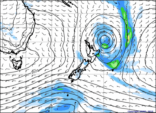
However ..........
this animated wind map from weather-forecast.com shows it going right over New Caledonia
Queensland
HURRICANE WARNING 088 ISSUED FROM RSMC NADI Dec 31/1901 UTC 2012 UTC.
SEVERE TROPICAL CYCLONE FREDA CENTRE 965HPA CATEGORY 3 WAS LOCATED NEAR 18.5
SOUTH 162.0 EAST AT 311800 UTC.
POSITION POOR.
REPEAT POSITION 18.5S 162.0E AT 311800 UTC.
CYCLONE MOVING SOUTH SOUTHEAST AT 9 KNOTS. CYCLONE GRADUALLY WEAKENING.
EXPECT SUSTAINED WINDS OF 80 KNOTS CLOSE TO THE CENTRE DECREASING TO 60 KNOTS BY
011800 UTC.
However ..........
this animated wind map from weather-forecast.com shows it going right over New Caledonia
edit on 31-12-2012 by muzzy because: (no reason given)
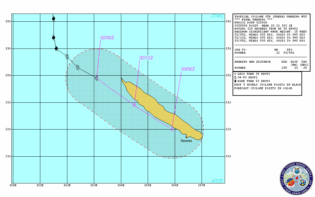
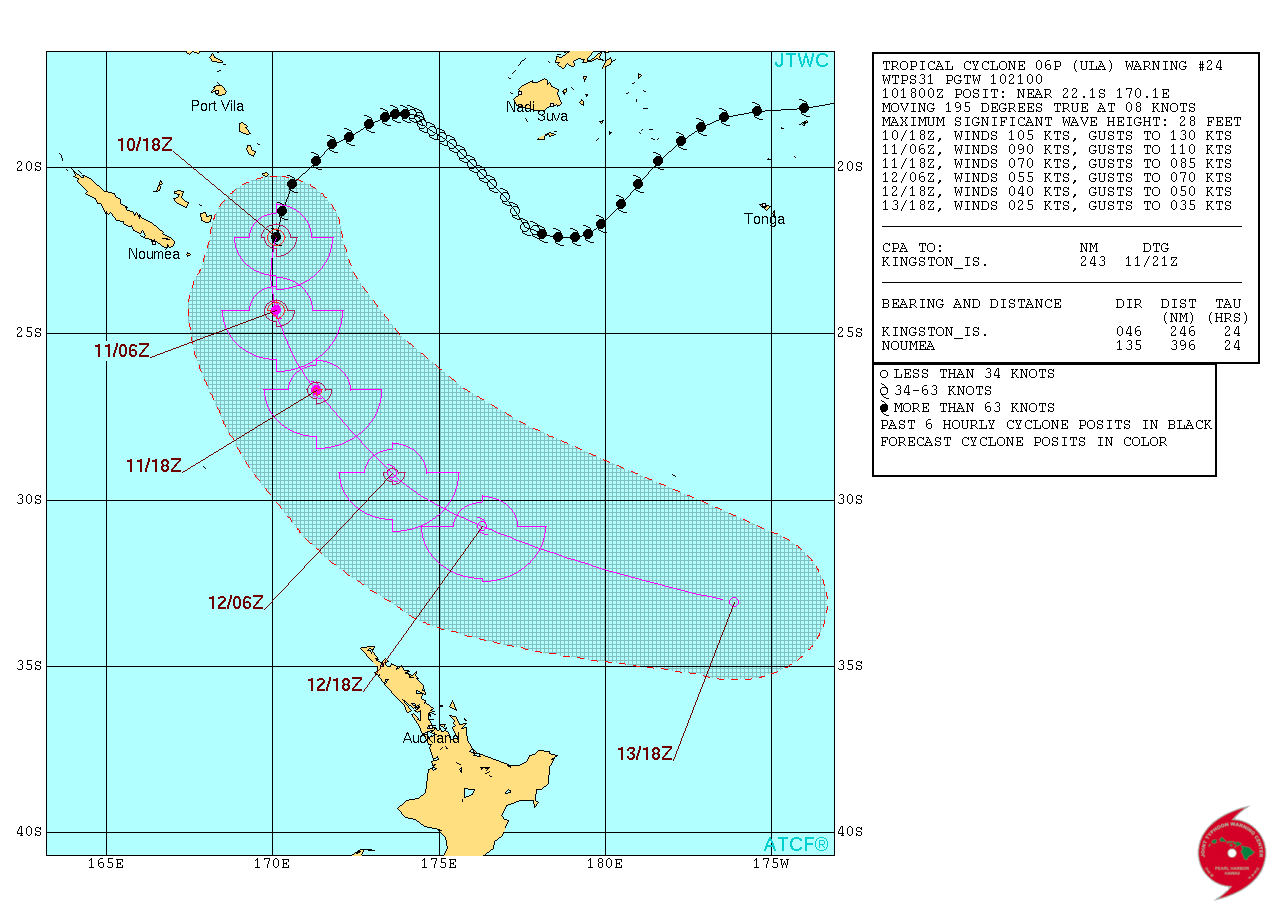
Freda Tracking
Warning #9
they sure got that one wrong,it went straight SE
Warning #10
tracked right over New Caledonia, didn't read about or see any footage of damage
the TC now an ex-TC and just a depression of the NE coast of the North Island of New Zealand.
been raining on the East Cape/Gisborne/Mahia Peninsula today
from Mahia Weather Station;
Rainfall Today 6.6 mm
Rainfall Rate Max 115.2 mm/hr at 06:10
High Hourly Rainfall 9.6 mm at 07:05
Warning #9

they sure got that one wrong,it went straight SE
Warning #10
tracked right over New Caledonia, didn't read about or see any footage of damage
the TC now an ex-TC and just a depression of the NE coast of the North Island of New Zealand.
been raining on the East Cape/Gisborne/Mahia Peninsula today
from Mahia Weather Station;
Rainfall Today 6.6 mm
Rainfall Rate Max 115.2 mm/hr at 06:10
High Hourly Rainfall 9.6 mm at 07:05
edit on 6-1-2013 by muzzy because: (no reason given)
First potentially threatening cyclone for the season has just been named and is possibly heading towards the northwest coast in a couple of days.
I'm currently in Port Hedland...so yay me.
Will be keeping a VERY close eye on this

I'm currently in Port Hedland...so yay me.
Will be keeping a VERY close eye on this
Didn't really follow this through in 2013
Just found this, seems a recent development
a visualization of global weather conditions
forecast by supercomputers
updated every three hours
earth.nullschool.net...
rotate the globe around with your cursor
seems reasonably accurate, there is rain about to come through Cook Strait (NZ) tonight, shows as green and all the Tasman Sea arrows are pointing to there and the SI west coast in the next 24 hrs
click on the word earth for the tools to go forward or back in time, too bad you can't zoom in closer.
Was just checking further, current Cyclone in the Indian Ocean, TC Amara, shows on the Global Weather Conditions, clicking "-1day", "now" and "1day", its moving quite fast!
Just found this, seems a recent development
a visualization of global weather conditions
forecast by supercomputers
updated every three hours
earth.nullschool.net...
rotate the globe around with your cursor
seems reasonably accurate, there is rain about to come through Cook Strait (NZ) tonight, shows as green and all the Tasman Sea arrows are pointing to there and the SI west coast in the next 24 hrs
click on the word earth for the tools to go forward or back in time, too bad you can't zoom in closer.
edit on 1200000035535513 by muzzy
because: (no reason given)
Was just checking further, current Cyclone in the Indian Ocean, TC Amara, shows on the Global Weather Conditions, clicking "-1day", "now" and "1day", its moving quite fast!
edit on 12u35535513 by muzzy because: (no reason
given)
Blown out now but was quite a cyclone according to Au news reports. Pilbara Region
www.usno.navy.mil...

IDW24100
Australian Government Bureau of Meteorology
Western Australia
Tropical Cyclone Warning Centre
Media: The Standard Emergency Warning Signal should NOT be used with this
warning.
PRIORITY
TROPICAL CYCLONE ADVICE NUMBER 55
Issued at 2:19 am WST on Wednesday 1 January 2014
The Cyclone WARNING for inland parts of the Gascoyne has been CANCELLED
At 2:00 am WST Ex-Tropical Cyclone Christine, was estimated to be
145 kilometres east northeast of Meekatharra and
55 kilometres northwest of Wiluna and
moving southeast at 34 kilometres per hour.
Although Ex-TC Christine has weakened below tropical cyclone intensity,
damaging wind gusts are likely to continue on the northeastern side of the
system during Wednesday as it moves quickly across southeastern WA. Please
refer to Severe Weather Warning (IDW28001) for further details.
Moderate to heavy rainfall is expected near the track. A Flood Watch has been
issued for the Goldfields.
DFES State Emergency Service (SES) advises of the following community alerts:
ALL CLEAR WITH CAUTION: People in inland parts of the northern Gascoyne,
including the Collier Ranges, Three Rivers, Kumarina, Granite Peak and Wiluna
are advised that the threat of cyclonic weather has passed.
People close to the track of ex-TC Christine still need to take caution when
heading outside and heed the Severe Weather Warning that has been issued.
Details of the Ex-Tropical Cyclone Christine at 2:00 am WST:
.Centre located near...... 26.2 degrees South 119.9 degrees East
.Location accuracy........ within 55 kilometres
.Recent movement.......... towards the southeast at 34 kilometres per hour
.Wind gusts near centre... 85 kilometres per hour
.Severity category........ below cyclone intensity
.Central pressure......... 992 hectoPascals
No further advices will be issued for this system.
www.usno.navy.mil...
edit on 1200000036436413 by muzzy because: (no reason given)
Typhoon warning issued for Guam and surrounding areas. The typhoon Vongfong will pass with devastating force over the island of Rota. Its currently
class 3 typhoon.
Typhoon Vongfong: Typhoon Warnings Issued for Guam, Northern Mariana Islands; "Devastating Damage" Predicted
The National Weather Service in Guam warning of potentially disastrous impacts as Typhoon Vongfong races toward Guam and the Northern Mariana Islands while it continues to strengthen.
In a statement issued Sunday morning local time (Saturday evening U.S. East Coast time), the NWS office warned that "devastating damage is expected" on the island of Rota, which lies about 45 miles northeast of Guam in the Northern Mariana Islands, a U.S. commonwealth.
The bulletin, eerily reminiscent of one issued by the NWS New Orleans office before Hurricane Katrina in August 2005, includes these ominous descriptions of potential destruction from winds forecast to gust as high as 130 mph:
"Collapse of some residential structures will put lives at risk. Airborne debris will cause extensive damage. Persons or animals struck by the wind blown debris will be injured or killed. Electricity and water will be unavailable for days and perhaps weeks after the storm passes. Most trees will be snapped or uprooted. Fallen trees may cut off residential areas for days to weeks."
Weather.com

a reply to: Thebel
Just read the local Finnish online news-tabloid, stating it is now a class 4, and when hitting Okinawa possibly gusting at 70-80 mph.. This will be late Saturday or early Sunday, but the news doesn't tell the timezone.. If local Finnish time (GMT +2) it would be early to late Sunday in Japan, but don't rely on my time converting skills
Here is the link, but unfortunatly in Finnish, so I guess there won't be that many understanding it.. But I summed up the relevant parts above.
Let's hope everybody will be safe :/
Link to Finnish tabloid-news site
a reply to: muzzy
I have a look at that every time there is a news report about bad weather coming, great overview.
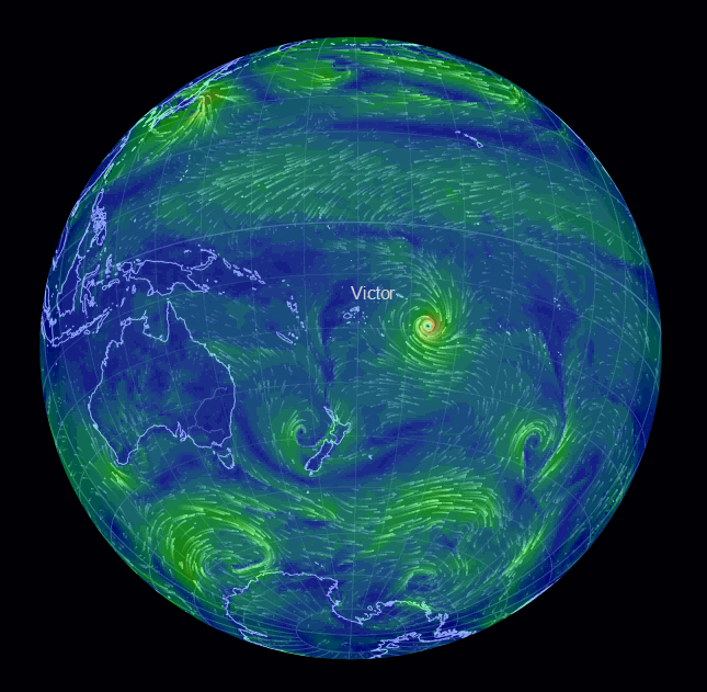
Anyway, there are 2 Cyclones currently Mid Pacific (Invest) and South Pacific (Ula)
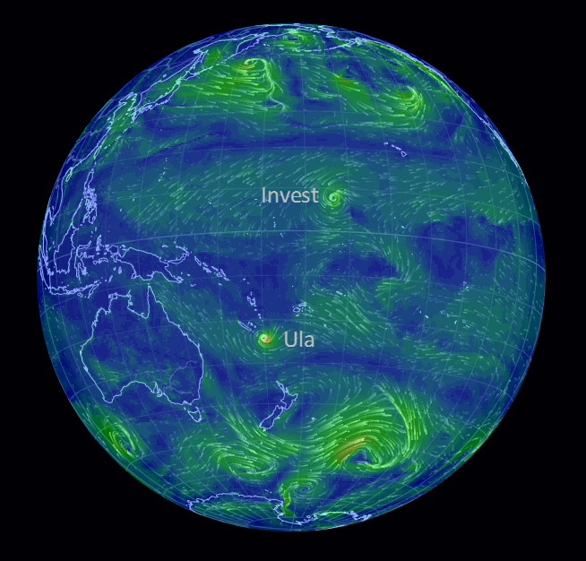
rightclickviewimagesforfullsize
news report www.stuff.co.nz...
I have a look at that every time there is a news report about bad weather coming, great overview.
Anyway, there are 2 Cyclones currently Mid Pacific (Invest) and South Pacific (Ula)
rightclickviewimagesforfullsize
news report www.stuff.co.nz...
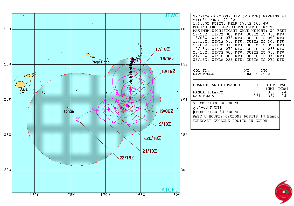
Special Weather Bulletin Number THIRTY SIX for Northern Cooks ON
SEVERE TROPICAL CYCLONE VICTOR AND AN ACTIVE CONVERGENCE ZONE ISSUED
FROM RSMC NADI
Jan 180156 UTC.
GALE WARNING
A GALE WARNING REMAINS IN FORCE FOR SUWARROW.
A STRONG WIND WARNING REMAINS IN FORCE FOR THE REST OF NORTHERN
COOKS.
SEVERE TROPICAL CYCLONE VICTOR [975HPA] CATEGORY 3 WAS LOCATED NEAR
18.1 DEGREES SOUTH 166.3 DEGREES WEST AT 180000UTC. POSITION POOR.
CYCLONE MOVING SOUTH AT 06 KNOTS AND IS MOVING FURTHER AWAY FROM
NORTHERN COOKS.
AN ACTIVE CONVERGENCE ZONE WITH ASSOCIATED GALE FORCE WINDS REMAINS
SLOW MOVING OVER NORTHERN COOKS.
FOR SUWARROW:
WEST TO NORTHWEST WINDS 30 TO 35 KNOTS WITH GUSTS TO 50 KNOTS. WINDS
EASING AND BECOMING 25 TO 30 KNOTS IN NEXT 06 HOURS. PERIODS OF RAIN,
HEAVY AT TIMES AND SQUALLY THUNDERSTORMS. SEA FLOODING OF LOW LYING
AREAS LIKELY. VERY ROUGH TO HIGH SEAS. MODERATE TO HEAVY NORTHERLY
SWELLS.
FOR THE REST OF NORTHERN COOK ISLANDS:
NORTHERLY WINDS 20 TO 30 KNOTS WITH GUSTS UP TO 45 KNOTS. WINDS
EASING TO 20 TO 25 KNOTS IN THE NEXT 09 HOURS. OCCASIONAL RAIN,
HEAVY AT TIMES AND SQUALLY THUNDERSTORMS. SEA FLOODING OF LOW LYING
AREAS LIKELY. ROUGH TO VERY ROUGH SEAS. MODERATE TO HEAVY NORTHERLY
SWELLS.
THE NEXT SPECIAL WEATHER BULLETIN FOR THE NORTHERN COOKS ON SEVERE TC
VICTOR AND THE ACTIVE CONVERGENCE ZONE WILL BE ISSUED AT 180500 UTC
OR EARLIER.
rightclickviewimageforfullsize
edit on 01000000161616 by muzzy because: (no reason given)
a reply to: muzzy
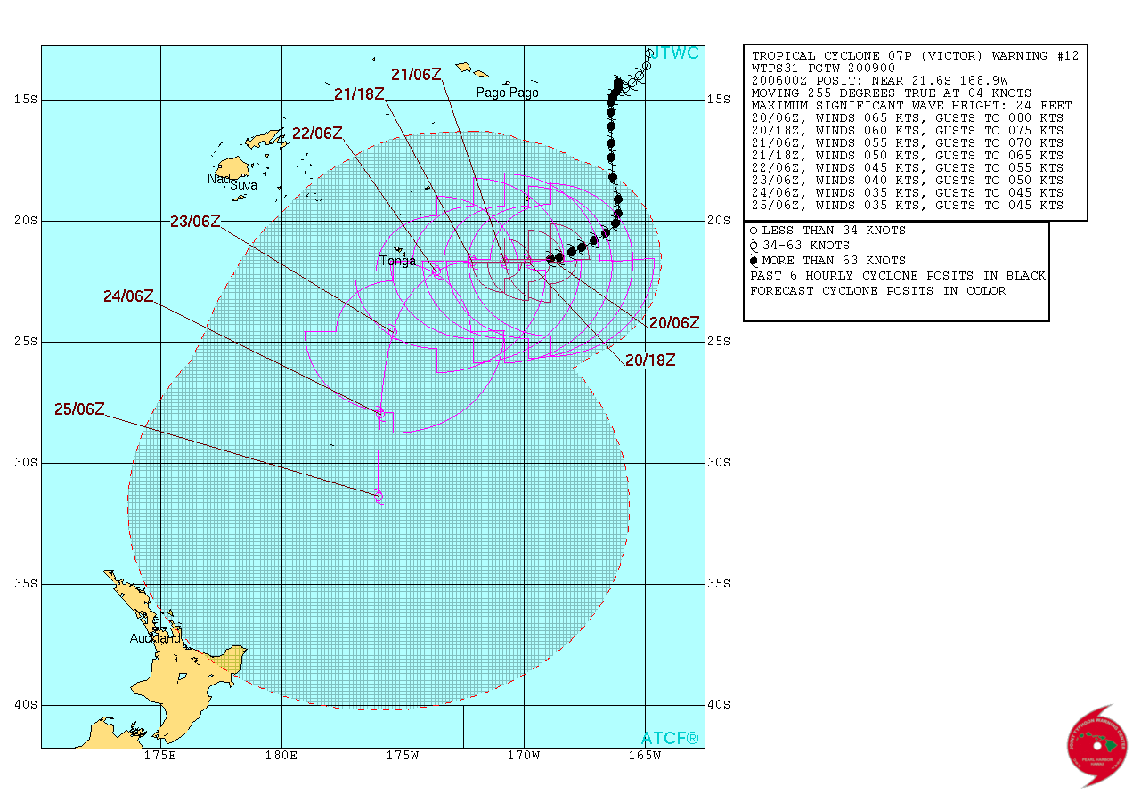
Special Weather Bulletin Number TWENTY for Niue ON TROPICAL CYCLONE VICTOR
ISSUED FROM RSMC NADI
Jan 201635 UTC.
TROPICAL CYCLONE WARNING
A GALE WIND WARNING REMAINS IN FORCE NIUE.
TROPICAL CYCLONE VICTOR CENTRE 975HPA CATEGORY 2 WAS LOCATED NEAR 21 DECIMAL 5
SOUTH 169 DECIMAL 3 WEST OR ABOUT 280KM SOUTH-SOUTHEAST OF NIUE AT 201500 UTC.
POSITION FAIR. VICTOR MOVING WEST-SOUTHWEST AT ABOUT 7 KM/HR. CLOSE TO ITS
CENTRE, THE CYCLONE IS ESTIMATED TO HAVE AVERAGE SUSTAINED WINDS OF 110 KM/HR
WITH MOMENTARY GUSTS TO 155 KM/HR.
ON THIS TRACK, THE CYCLONE IS EXPECTED TO BE LOCATED ABOUT 280KM SOUTH OF NIUE
AT 210300 UTC AND ABOUT 340KM SOUTH-SOUTHWEST OF NIUE AT 211500 UTC.
DAMAGING WINDS MAY BEGIN SEVERAL HOURS BEFORE THE CYCLONE CENTRE PASSES NEARBY.
FOR NIUE:
DAMAGING GALE FORCE WINDS WITH AVERAGE SPEED UP TO 65 KM/HR AND MOMENTARY GUSTS
TO 90KM/HR. OCCASIONAL RAIN, HEAVY AT TIMES AND SQUALLY THUNDERSTORMS. DAMAGING
HEAVY SWELLS WITH SEA FLOODING OF LOW LYING COASTAL AREAS POSSIBLE.
The following information is prvided especially for the Mariners:
GALE FORCE WINDS UP TO 40 KNOTS WITH MOMENTARY GUSTS TO 55 KNOTS. HIGH SEAS.
DAMAGING HEAVY SWELLS.
THE NEXT SPECIAL WEATHER BULLETIN FOR NIUE ON SEVERE TC VICTOR WILL BE ISSUED AT
OR AROUND 202000UTC.
rightclickviewimageforfullsize
edit on 01000000191916 by muzzy because: (no reason given)
a reply to: muzzy
GALE WARNING 111 ISSUED FROM RSMC NADI Jan 220654 UTC.
TROPICAL CYCLONE VICTOR CENTRE 995HPA CATEGORY 1 WAS LOCATED NEAR
22.0 SOUTH 174.4 WEST AT 220600 UTC.
POSITION GOOD.
REPEAT POSITION 22.0S 174.4W at 220600 UTC.
CYCLONE MOVING WEST AT 9 KNOTS. CYCLONE WEAKENING.
EXPECT SUSTAINED WINDS OF 35 KNOTS CLOSE TO THE CENTRE DECREASING TO
30 KNOTS BY 221200 UTC.
EXPECT WINDS OVER 33 KNOTS WITHIN 30 NAUTICAL MILES IN N SEMICIRCLE,
WITHIN 150 NAUTICAL MILES IN SE QUADRANT,
AND WITHIN 100 NAUTICAL MILES IN SW QUADRANT.
FORECAST POSITION NEAR 23.3S 175.8W AT 221800 UTC
AND NEAR 25.2S 176.3W AT 230600 UTC.
ALL VESSELS WITHIN 300 NAUTICAL MILES OF CENTRE ARE REQUESTED TO SEND
REPORTS EVERY THREE HOURS TO RSMC NADI. VOS REPORTING SHIPS USE
NORMAL CHANNELS. OTHER VESSELS FAX PLUS 679 6720190 OR EMAIL NADITCC
AT MET DOT GOV DOT FJ
THIS WARNING CANCELS AND REPLACES WARNING 110.
edit on 01000000212116 by muzzy because: (no reason given)
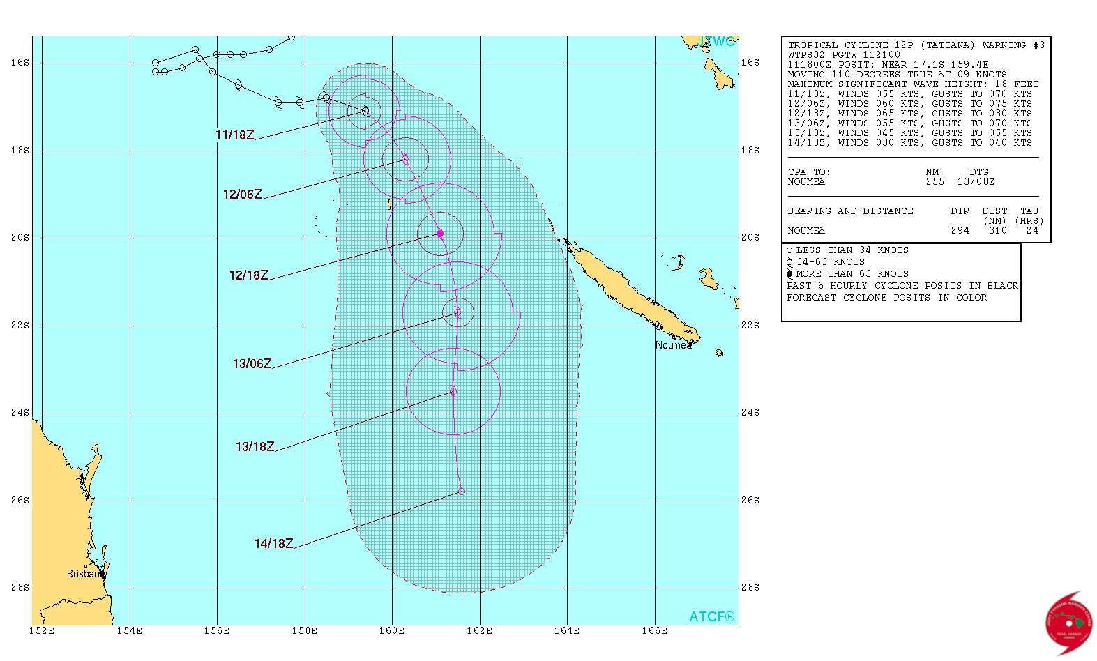
TC TATIANA
REMARKS:
112100Z POSITION NEAR 17.4S 159.6E.
TROPICAL CYCLONE (TC) 12P (TATIANA), LOCATED APPROXIMATELY 483 NM
NORTHWEST OF NOUMEA, NEW CALEDONIA, HAS TRACKED EAST-SOUTHEASTWARD
AT 09 KNOTS OVER THE PAST SIX HOURS. ANIMATED MULTISPECTRAL
SATELLITE IMAGERY DEPICTS AN AREA OF SYMMETRIC COLD DENSE OVERCAST
OBSCURING A LOW LEVEL CIRCULATION CENTER (LLCC). A 111703Z SSMIS
91GHZ IMAGE SHOWS A TIGHTLY SPIRALED LLCC WITH SHALLOW BANDS OF
CONVECTION GIVING HIGH CONFIDENCE TO THE INITIAL POSITION. THE
INITIAL INTENSITY IS ASSESSED AT 55 KNOTS WHICH IS BASED ON DVORAK
ESTIMATES FROM MULTIPLE AGENCIES IN CLOSE AGREEMENT. UPPER-LEVEL
CONDITIONS ARE STILL FAVORABLE FOR DEVELOPMENT IN THE SHORT TERM
WITH 15 TO 20 KNOTS OF VERTICAL WIND SHEAR AND A STRONG POLEWARD
OUTFLOW CHANNEL. THE PRIMARY STEERING MECHANISM FOR TATIANA IS AN
INDUCED MID-LEVEL RIDGE POSITIONED TO THE EAST WHICH IS FORECASTED
TO SHIFT THE TRACK SOUTHWARD. EXHAUST FROM TC WINSTON POSITIONED
APPROXIMATELY 850 NM TO THE EAST IS PREVENTING TC TATIANA FROM
DEVELOPING ADDITIONAL OUTFLOW CHANNELS AND WILL LIMIT INTENSITY
DEVELOPMENT TO 65 KNOTS BY TAU 24. AS TC TATIANA TRAVELS SOUTH
BEYOND TAU 24, VWS IS EXPECTED TO INCREASE AS THE CYCLONE INTERACTS
WITH A MID TO UPPER-LEVEL TROUGH MOVING IN FROM THE WEST, COUPLED
WITH STRENGTHENING EXHAUST PROVIDED FROM TC WINSTON AND EVENTUALLY
DISSIPATE BY TAU 72. DYNAMIC MODEL GUIDANCE IS IN POOR AGREEMENT
GIVING RELATIVELY LOW CONFIDENCE TO THE FORECAST. MAXIMUM
SIGNIFICANT WAVE HEIGHT AT 111800Z IS 18 FEET. NEXT WARNINGS AT
120900Z AND 122100Z. REFER TO TROPICAL CYCLONE 11P (WINSTON)
WARNINGS (WTPS31 PGTW) FOR SIX-HOURLY UPDATES.//
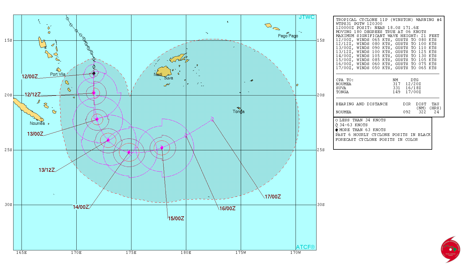
TC WINSTON
REMARKS:
120300Z POSITION NEAR 18.4S 171.6E.
TROPICAL CYCLONE 11P (WINSTON), LOCATED APPROXIMATELY 388 NM WEST
OF SUVA, FIJI, HAS TRACKED SOUTHWARD AT 06 KNOTS OVER THE PAST
SIX HOURS. ANIMATED MULTISPECTRAL SATELLITE IMAGERY DEPICTS DEEP
CONVECTION WRAPPING INTO A TIGHT SYMMETRIC SPIRAL WITH AN EYEWALL
BEGINNING TO FORM. A 112144Z MHS 89 GHZ MICROWAVE IMAGE SHOWS DEEP
CONVECTION ON THE NORTHERN PERIPHERY OF A WELL-DEFINED LOW LEVEL
CIRCULATION CENTER GIVING HIGH CONFIDENCE TO THE INITIAL POSITION.
THE INITIAL INTENSITY IS BASED ON DVORAK ESTIMATES OF 4.0 (65 KNOTS)
FROM PGTW AND PHFO. THE UPPER-LEVEL ENVIRONMENT IS FAVORABLE WITH
RADIAL OUTFLOW AND LOW (5 TO 10 KNOT) VERTICAL WIND SHEAR WHICH
WILL SUPPORT FURTHER INTENSIFICATION. TROPICAL CYCLONE (TC) WINSTON
IS CURRENTLY TRAVELING SOUTHWARD ALONG THE WESTERN PERIPHERY OF A
SUBTROPICAL RIDGE. BY TAU 48 THE SUBTROPICAL RIDGE WILL REPOSITION
TO THE NORTH AND STEER TC WINSTON ON A NORTHEASTWARD TRACK. DYNAMIC
MODEL GUIDANCE IS IN GOOD AGREEMENT GIVING HIGH CONFIDENCE TO THE
FORECAST TRACK. MAXIMUM SIGNIFICANT WAVE HEIGHT AT 120000Z IS 21
FEET. NEXT WARNINGS AT 121500Z AND 130300Z. REFER TO TROPICAL
CYCLONE 12P (TATIANA) WARNINGS (WTPS32 PGTW) FOR SIX-HOURLY UPDATES.
REMARKS:
112100Z POSITION NEAR 17.4S 159.6E.
TROPICAL CYCLONE (TC) 12P (TATIANA), LOCATED APPROXIMATELY 483 NM
NORTHWEST OF NOUMEA, NEW CALEDONIA, HAS TRACKED EAST-SOUTHEASTWARD
AT 09 KNOTS OVER THE PAST SIX HOURS. ANIMATED MULTISPECTRAL
SATELLITE IMAGERY DEPICTS AN AREA OF SYMMETRIC COLD DENSE OVERCAST
OBSCURING A LOW LEVEL CIRCULATION CENTER (LLCC). A 111703Z SSMIS
91GHZ IMAGE SHOWS A TIGHTLY SPIRALED LLCC WITH SHALLOW BANDS OF
CONVECTION GIVING HIGH CONFIDENCE TO THE INITIAL POSITION. THE
INITIAL INTENSITY IS ASSESSED AT 55 KNOTS WHICH IS BASED ON DVORAK
ESTIMATES FROM MULTIPLE AGENCIES IN CLOSE AGREEMENT. UPPER-LEVEL
CONDITIONS ARE STILL FAVORABLE FOR DEVELOPMENT IN THE SHORT TERM
WITH 15 TO 20 KNOTS OF VERTICAL WIND SHEAR AND A STRONG POLEWARD
OUTFLOW CHANNEL. THE PRIMARY STEERING MECHANISM FOR TATIANA IS AN
INDUCED MID-LEVEL RIDGE POSITIONED TO THE EAST WHICH IS FORECASTED
TO SHIFT THE TRACK SOUTHWARD. EXHAUST FROM TC WINSTON POSITIONED
APPROXIMATELY 850 NM TO THE EAST IS PREVENTING TC TATIANA FROM
DEVELOPING ADDITIONAL OUTFLOW CHANNELS AND WILL LIMIT INTENSITY
DEVELOPMENT TO 65 KNOTS BY TAU 24. AS TC TATIANA TRAVELS SOUTH
BEYOND TAU 24, VWS IS EXPECTED TO INCREASE AS THE CYCLONE INTERACTS
WITH A MID TO UPPER-LEVEL TROUGH MOVING IN FROM THE WEST, COUPLED
WITH STRENGTHENING EXHAUST PROVIDED FROM TC WINSTON AND EVENTUALLY
DISSIPATE BY TAU 72. DYNAMIC MODEL GUIDANCE IS IN POOR AGREEMENT
GIVING RELATIVELY LOW CONFIDENCE TO THE FORECAST. MAXIMUM
SIGNIFICANT WAVE HEIGHT AT 111800Z IS 18 FEET. NEXT WARNINGS AT
120900Z AND 122100Z. REFER TO TROPICAL CYCLONE 11P (WINSTON)
WARNINGS (WTPS31 PGTW) FOR SIX-HOURLY UPDATES.//
TC WINSTON
REMARKS:
120300Z POSITION NEAR 18.4S 171.6E.
TROPICAL CYCLONE 11P (WINSTON), LOCATED APPROXIMATELY 388 NM WEST
OF SUVA, FIJI, HAS TRACKED SOUTHWARD AT 06 KNOTS OVER THE PAST
SIX HOURS. ANIMATED MULTISPECTRAL SATELLITE IMAGERY DEPICTS DEEP
CONVECTION WRAPPING INTO A TIGHT SYMMETRIC SPIRAL WITH AN EYEWALL
BEGINNING TO FORM. A 112144Z MHS 89 GHZ MICROWAVE IMAGE SHOWS DEEP
CONVECTION ON THE NORTHERN PERIPHERY OF A WELL-DEFINED LOW LEVEL
CIRCULATION CENTER GIVING HIGH CONFIDENCE TO THE INITIAL POSITION.
THE INITIAL INTENSITY IS BASED ON DVORAK ESTIMATES OF 4.0 (65 KNOTS)
FROM PGTW AND PHFO. THE UPPER-LEVEL ENVIRONMENT IS FAVORABLE WITH
RADIAL OUTFLOW AND LOW (5 TO 10 KNOT) VERTICAL WIND SHEAR WHICH
WILL SUPPORT FURTHER INTENSIFICATION. TROPICAL CYCLONE (TC) WINSTON
IS CURRENTLY TRAVELING SOUTHWARD ALONG THE WESTERN PERIPHERY OF A
SUBTROPICAL RIDGE. BY TAU 48 THE SUBTROPICAL RIDGE WILL REPOSITION
TO THE NORTH AND STEER TC WINSTON ON A NORTHEASTWARD TRACK. DYNAMIC
MODEL GUIDANCE IS IN GOOD AGREEMENT GIVING HIGH CONFIDENCE TO THE
FORECAST TRACK. MAXIMUM SIGNIFICANT WAVE HEIGHT AT 120000Z IS 21
FEET. NEXT WARNINGS AT 121500Z AND 130300Z. REFER TO TROPICAL
CYCLONE 12P (TATIANA) WARNINGS (WTPS32 PGTW) FOR SIX-HOURLY UPDATES.
a reply to: muzzy
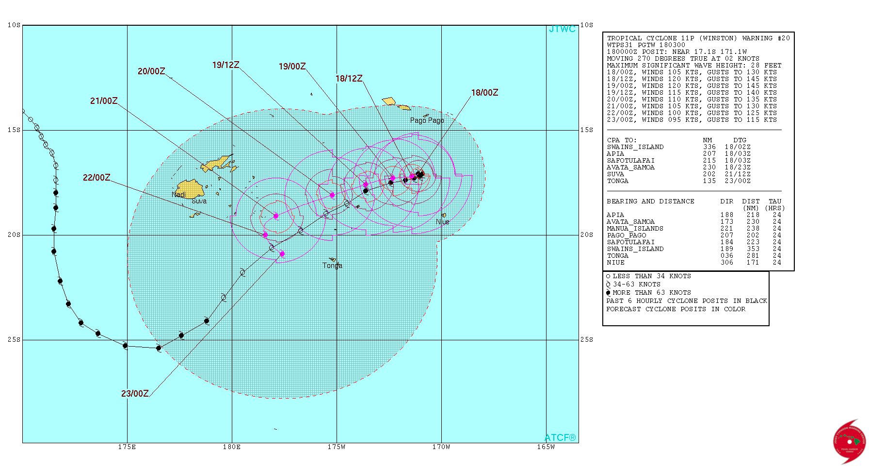
Update on TC Winston
After heading NW between Nuie and Samoa it is about to do a U turn and head back towards Fiji.
REMARKS:
180300Z POSITION NEAR 17.1S 171.2W.
TROPICAL CYCLONE (TC) 11P (WINSTON), LOCATED APPROXIMATELY 138 NM
NORTH-NORTHWEST OF NIUE, HAS TRACKED WESTWARD AT 02 KNOTS OVER
THE PAST SIX HOURS. ANIMATED MULTISPECTRAL SATELLITE IMAGERY
SHOWS DEEPENED CENTRAL CONVECTION WITH A DEVELOPING EYE, SUPPORTING
THE HIGH CONFIDENCE IN THE CURRENT POSITION. THE INITIAL INTENSITY
OF 105 KNOTS IS BASED ON AN OVERALL ASSESSMENT OF DVORAK INTENSITY
ESTIMATES FROM ALL REPORTING AGENCIES AND THE IMPROVED STRUCTURE.
UPPER-LEVEL ANALYSIS INDICATES WINSTON IS LOCATED IN A FAVORABLE
ENVIRONMENT WITH LOW (10 TO 15 KNOT) VERTICAL WIND SHEAR AND GOOD
POLEWARD OUTFLOW. ADDITIONALLY, SEA SURFACE TEMPERATURES (30 DEGREES
CELSIUS) ARE CONDUCIVE FOR FURTHER DEVELOPMENT. FAVORABLE CONDITIONS
ARE FORECAST TO PERSIST, ALLOWING STEADY INTENSIFICATION OVER THE
NEXT 24 HOURS, LEADING TO A PEAK INTENSITY OF 120 KNOTS. AFTERWARD,
UPPER-LEVEL CONDITIONS WILL SLOWLY DEGRADE, LEADING TO ITS WEAKENING
TREND. SLOW AND/OR QUASI-STATIONARY MOVEMENT IS EXPECTED AS TC
WINSTON REMAINS IN A WEAK STEERING ENVIRONMENT FOR THE NEXT 12 TO 18
HOURS. THE SYSTEM IS FORECAST TO TRACK WESTWARD AS THE STR TO THE
SOUTH BECOMES DOMINANT. DUE TO SIGNIFICANT DIFFERENCES IN THE TRACKS
AND TRACK SPEEDS AMONG AVAILABLE TRACKERS, THE JTWC TRACK CONFIDENCE
LEVEL REMAINS LOW. MAXIMUM SIGNIFICANT WAVE HEIGHT AT 180000Z IS 28
FEET. NEXT WARNINGS AT 180900Z, 181500Z, 182100Z AND 190300Z
righclickviewimageforfullsize
Fiji may get a direct hit from TC Winstono n the 21st Feb
I made this animation using , EarthWind, taken at Surface level, 24 hrs apart starts now at 18th 1600UTC then 19th 1600UTC etc through to the 22nd 1600UTC
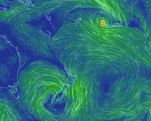
Also we should be taking more notice of theFiji Meteorological Service, RSMC - Tropical Cyclone Centre on this one now
TROPICAL DISTURBANCE ADVISORY NUMBER A31 ISSUED FROM RSMC NADI
Feb 180110 UTC.
SEVERE TROPICAL CYCLONE WINSTON CENTRE 953HPA CATEGORY 4 WAS LOCATED
NEAR 17.0 SOUTH 171.1 WEST AT 180000 UTC. POSITION FAIR BASED ON HR
GOES VIS IMAGERY AND PERIPHERAL SURFACE OBSERVATIONS. CYCLONE MOVING
WEST AT 05 KNOTS. EXPECT SUSTAINED WINDS OF 90 KNOTS CLOSE TO THE
CENTRE...............
www.met.gov.fj...
Update on TC Winston
After heading NW between Nuie and Samoa it is about to do a U turn and head back towards Fiji.
REMARKS:
180300Z POSITION NEAR 17.1S 171.2W.
TROPICAL CYCLONE (TC) 11P (WINSTON), LOCATED APPROXIMATELY 138 NM
NORTH-NORTHWEST OF NIUE, HAS TRACKED WESTWARD AT 02 KNOTS OVER
THE PAST SIX HOURS. ANIMATED MULTISPECTRAL SATELLITE IMAGERY
SHOWS DEEPENED CENTRAL CONVECTION WITH A DEVELOPING EYE, SUPPORTING
THE HIGH CONFIDENCE IN THE CURRENT POSITION. THE INITIAL INTENSITY
OF 105 KNOTS IS BASED ON AN OVERALL ASSESSMENT OF DVORAK INTENSITY
ESTIMATES FROM ALL REPORTING AGENCIES AND THE IMPROVED STRUCTURE.
UPPER-LEVEL ANALYSIS INDICATES WINSTON IS LOCATED IN A FAVORABLE
ENVIRONMENT WITH LOW (10 TO 15 KNOT) VERTICAL WIND SHEAR AND GOOD
POLEWARD OUTFLOW. ADDITIONALLY, SEA SURFACE TEMPERATURES (30 DEGREES
CELSIUS) ARE CONDUCIVE FOR FURTHER DEVELOPMENT. FAVORABLE CONDITIONS
ARE FORECAST TO PERSIST, ALLOWING STEADY INTENSIFICATION OVER THE
NEXT 24 HOURS, LEADING TO A PEAK INTENSITY OF 120 KNOTS. AFTERWARD,
UPPER-LEVEL CONDITIONS WILL SLOWLY DEGRADE, LEADING TO ITS WEAKENING
TREND. SLOW AND/OR QUASI-STATIONARY MOVEMENT IS EXPECTED AS TC
WINSTON REMAINS IN A WEAK STEERING ENVIRONMENT FOR THE NEXT 12 TO 18
HOURS. THE SYSTEM IS FORECAST TO TRACK WESTWARD AS THE STR TO THE
SOUTH BECOMES DOMINANT. DUE TO SIGNIFICANT DIFFERENCES IN THE TRACKS
AND TRACK SPEEDS AMONG AVAILABLE TRACKERS, THE JTWC TRACK CONFIDENCE
LEVEL REMAINS LOW. MAXIMUM SIGNIFICANT WAVE HEIGHT AT 180000Z IS 28
FEET. NEXT WARNINGS AT 180900Z, 181500Z, 182100Z AND 190300Z
righclickviewimageforfullsize
edit on 02000000484816 by muzzy because: (no reason given)
Fiji may get a direct hit from TC Winstono n the 21st Feb
I made this animation using , EarthWind, taken at Surface level, 24 hrs apart starts now at 18th 1600UTC then 19th 1600UTC etc through to the 22nd 1600UTC
Also we should be taking more notice of theFiji Meteorological Service, RSMC - Tropical Cyclone Centre on this one now
TROPICAL DISTURBANCE ADVISORY NUMBER A31 ISSUED FROM RSMC NADI
Feb 180110 UTC.
SEVERE TROPICAL CYCLONE WINSTON CENTRE 953HPA CATEGORY 4 WAS LOCATED
NEAR 17.0 SOUTH 171.1 WEST AT 180000 UTC. POSITION FAIR BASED ON HR
GOES VIS IMAGERY AND PERIPHERAL SURFACE OBSERVATIONS. CYCLONE MOVING
WEST AT 05 KNOTS. EXPECT SUSTAINED WINDS OF 90 KNOTS CLOSE TO THE
CENTRE...............
www.met.gov.fj...
edit on 02000000484816 by muzzy because: (no reason given)
edit on 02000000484816 by
muzzy because: (no reason given)
This is the highest category Cyclone to ever hit Fiji.
Special Weather Bulletin Number THIRTY THREE for Fiji ON SEVERE
TROPICAL CYCLONE WINSTON
ISSUED FROM RSMC NADI at 4:17pm on Saturday the 20th of February 2016
TROPICAL CYCLONE WARNING.
A HURRICANE WARNING REMAINS IN FORCE FOR VANUA LEVU, TAVEUNI AND THE
NEARBY SMALLER ISLANDS, NORTHERN HALF OF VITI LEVU, OVALAU, GAU,
BATIKI, NAIRAI AND KORO.
www.met.gov.fj...
new track from Naval Maritime Forecast Center/Joint Typhoon Warning Center
rightclickviewimageforfullsize
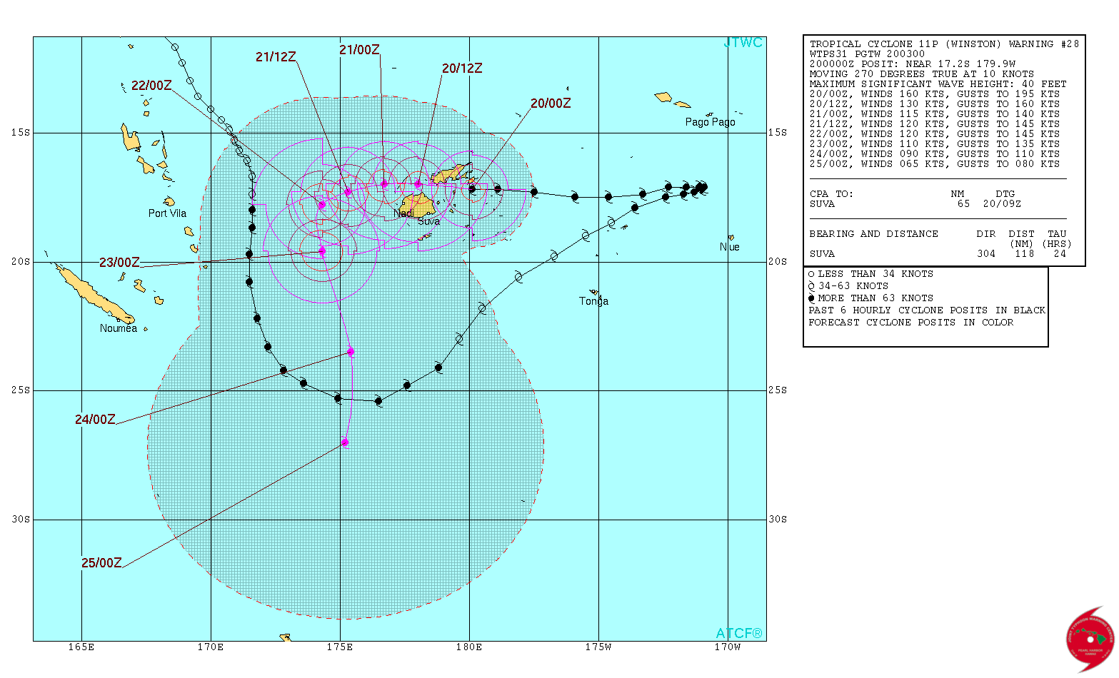
A STORM WARNING REMAINS IN FORCE FOR SOUTHERN HALF VITI LEVU, YASAWA
AND MAMANUCA GROUP, VANUABALAVU, YACATA, MAGO, CICIA, TUVUCA, NAYAU
AND VANUAVATU AND MOALA.
A GALE WARNING REMAINS IN FORCE FOR THE REST OF FIJI.
A DAMAGING HEAVY SWELL WARNING REMAINS IN FORCE FOR LOW LYING COASTAL
AREAS OF FIJI.
A HEAVY RAIN WARNING REMAINS IN FORCE FOR FIJI.
SEVERE TROPICAL CYCLONE WINSTON CENTRE [917HPA] CATEGORY 5 WAS
LOCATED NEAR 17.2 SOUTH 179.3 EAST OR ABOUT 90KM WEST-SOUTHWEST OF
TAVEUNI OR ABOUT 140KM NORTHEAST OF SUVA AT 3PM TODAY. THE CYCLONE IS
MOVING WEST AT ABOUT 25KM/HR. CLOSE TO ITS CENTRE, THE CYCLONE IS
ESTIMATED TO HAVE AVERAGE WINDS OF 230KM/HR AND MOMENTARY GUSTS TO
325KM/HR.
ON THIS TRACK, THE CYCLONE IS EXPECTED TO BE LOCATED ABOUT 60KM SOUTH
OF YASAWA-I-RARA OR ABOUT 60KM NORTH OF NADI 3AM TOMORROW AND ABOUT
165KM WEST-NORTHWEST OF YASAWA-I-RARA OR ABOUT 140KM WEST-NORTHWEST
OF NADI AT 3PM TOMORROW.
VERY DESTRUCTIVE WINDS MAY BEGIN SEVERAL HOURS BEFORE THE CYCLONE
CENTRE PASSES OVER HEAD OR NEARBY.
FOR VANUA LEVU, TAVEUNI AND THE NEARBY SMALLER ISLANDS, NORTHERN HALF
OF VITI LEVU, OVALAU, GAU, BATIKI, NAIRAI AND KORO:
EXPECT VERY DESTRUCTIVE HURRICANE FORCE WINDS WITH AVERAGE SPEED OF
220KM/HR AND MOMENTARY GUST TO 315KM/HR. HEAVY RAIN AND SQUALLY
THUNDERSTORMS. DAMAGING HEAVY SWELLS. FLOODING INCLUDING WITH SEA
FLOODING OF LOW LYING AREAS.
FOR SOUTHERN HALF VITI LEVU, YASAWA AND MAMANUCA GROUP, VANUABALAVU,
YACATA, MAGO, CICIA, TUVUCA, NAYAU AND VANUAVATU AND MOALA:
EXPECT DESTRUCTIVE STORM FORCE WINDS WITH AVERAGE SPEED OF 110KM/HR
AND MOMENTARY GUST TO 155KM/HR. HEAVY RAIN AND SQUALLY THUNDERSTORMS.
DAMAGING HEAVY SWELLS. FLOODING INCLUDING SEA FLOODING OF LOW LYING
AREAS.
FOR THE REST OF FIJI:
EXPECT DAMAGING GALE FORCE WINDS WITH AVERAGE SPEED OF 85KM/HR AND
MOMENTARY GUST TO 120KM/HR. PERIODS OF HEAVY RAIN AND SQUALLY
THUNDERSTORMS. DAMAGING HEAVY SWELLS. FLOODING INCLUDING SEA
FLOODING OF LOW LYING AREAS.
Special Weather Bulletin Number THIRTY THREE for Fiji ON SEVERE
TROPICAL CYCLONE WINSTON
ISSUED FROM RSMC NADI at 4:17pm on Saturday the 20th of February 2016
TROPICAL CYCLONE WARNING.
A HURRICANE WARNING REMAINS IN FORCE FOR VANUA LEVU, TAVEUNI AND THE
NEARBY SMALLER ISLANDS, NORTHERN HALF OF VITI LEVU, OVALAU, GAU,
BATIKI, NAIRAI AND KORO.
www.met.gov.fj...
new track from Naval Maritime Forecast Center/Joint Typhoon Warning Center
rightclickviewimageforfullsize
A STORM WARNING REMAINS IN FORCE FOR SOUTHERN HALF VITI LEVU, YASAWA
AND MAMANUCA GROUP, VANUABALAVU, YACATA, MAGO, CICIA, TUVUCA, NAYAU
AND VANUAVATU AND MOALA.
A GALE WARNING REMAINS IN FORCE FOR THE REST OF FIJI.
A DAMAGING HEAVY SWELL WARNING REMAINS IN FORCE FOR LOW LYING COASTAL
AREAS OF FIJI.
A HEAVY RAIN WARNING REMAINS IN FORCE FOR FIJI.
SEVERE TROPICAL CYCLONE WINSTON CENTRE [917HPA] CATEGORY 5 WAS
LOCATED NEAR 17.2 SOUTH 179.3 EAST OR ABOUT 90KM WEST-SOUTHWEST OF
TAVEUNI OR ABOUT 140KM NORTHEAST OF SUVA AT 3PM TODAY. THE CYCLONE IS
MOVING WEST AT ABOUT 25KM/HR. CLOSE TO ITS CENTRE, THE CYCLONE IS
ESTIMATED TO HAVE AVERAGE WINDS OF 230KM/HR AND MOMENTARY GUSTS TO
325KM/HR.
ON THIS TRACK, THE CYCLONE IS EXPECTED TO BE LOCATED ABOUT 60KM SOUTH
OF YASAWA-I-RARA OR ABOUT 60KM NORTH OF NADI 3AM TOMORROW AND ABOUT
165KM WEST-NORTHWEST OF YASAWA-I-RARA OR ABOUT 140KM WEST-NORTHWEST
OF NADI AT 3PM TOMORROW.
VERY DESTRUCTIVE WINDS MAY BEGIN SEVERAL HOURS BEFORE THE CYCLONE
CENTRE PASSES OVER HEAD OR NEARBY.
FOR VANUA LEVU, TAVEUNI AND THE NEARBY SMALLER ISLANDS, NORTHERN HALF
OF VITI LEVU, OVALAU, GAU, BATIKI, NAIRAI AND KORO:
EXPECT VERY DESTRUCTIVE HURRICANE FORCE WINDS WITH AVERAGE SPEED OF
220KM/HR AND MOMENTARY GUST TO 315KM/HR. HEAVY RAIN AND SQUALLY
THUNDERSTORMS. DAMAGING HEAVY SWELLS. FLOODING INCLUDING WITH SEA
FLOODING OF LOW LYING AREAS.
FOR SOUTHERN HALF VITI LEVU, YASAWA AND MAMANUCA GROUP, VANUABALAVU,
YACATA, MAGO, CICIA, TUVUCA, NAYAU AND VANUAVATU AND MOALA:
EXPECT DESTRUCTIVE STORM FORCE WINDS WITH AVERAGE SPEED OF 110KM/HR
AND MOMENTARY GUST TO 155KM/HR. HEAVY RAIN AND SQUALLY THUNDERSTORMS.
DAMAGING HEAVY SWELLS. FLOODING INCLUDING SEA FLOODING OF LOW LYING
AREAS.
FOR THE REST OF FIJI:
EXPECT DAMAGING GALE FORCE WINDS WITH AVERAGE SPEED OF 85KM/HR AND
MOMENTARY GUST TO 120KM/HR. PERIODS OF HEAVY RAIN AND SQUALLY
THUNDERSTORMS. DAMAGING HEAVY SWELLS. FLOODING INCLUDING SEA
FLOODING OF LOW LYING AREAS.
a reply to: muzzy
I know I've told you I like the EarthNullSchool map but in this case I didn't. Yesterday I noticed the storm. I was hoping it wasn't as bad as it looked. I was wrong and people have died and it has devastated the island and is in a state of disaster.
I know I've told you I like the EarthNullSchool map but in this case I didn't. Yesterday I noticed the storm. I was hoping it wasn't as bad as it looked. I was wrong and people have died and it has devastated the island and is in a state of disaster.
new topics
-
Russians And Americans At Same Airbase In Niger But Not Sharing Restrooms
World War Three: 1 hours ago -
US Air Force Secretary Kendall flies in cockpit of plane controlled by AI
Aircraft Projects: 5 hours ago -
Messages of Hope – Unity through AI
Dreams & Predictions: 6 hours ago -
Happy Cinco de mayo.
General Chit Chat: 7 hours ago -
The BEAST System of Revelation has been awoken and has assumed control, at least since COVID.
New World Order: 10 hours ago
top topics
-
The Department of Justice Spies on Congress with Google Assisting.
Political Conspiracies: 16 hours ago, 8 flags -
The BEAST System of Revelation has been awoken and has assumed control, at least since COVID.
New World Order: 10 hours ago, 6 flags -
Happy Cinco de mayo.
General Chit Chat: 7 hours ago, 1 flags -
Messages of Hope – Unity through AI
Dreams & Predictions: 6 hours ago, 1 flags -
US Air Force Secretary Kendall flies in cockpit of plane controlled by AI
Aircraft Projects: 5 hours ago, 1 flags -
Russians And Americans At Same Airbase In Niger But Not Sharing Restrooms
World War Three: 1 hours ago, 0 flags
active topics
-
Really Unexplained
General Chit Chat • 123 • : Beesnestbomber -
Israeli strikes on southern Gaza city of Rafah kill 22, mostly children, as US advances aid package
Middle East Issues • 152 • : Lazy88 -
Modern Mind Control
General Conspiracies • 38 • : Dreftenq -
Gov Kristi Noem Shot and Killed "Less Than Worthless Dog" and a 'Smelly Goat
2024 Elections • 172 • : network dude -
The Acronym Game .. Pt.3
General Chit Chat • 7803 • : bally001 -
The BEAST System of Revelation has been awoken and has assumed control, at least since COVID.
New World Order • 10 • : Dreftenq -
Zionists of ATS assemble
Political Issues • 177 • : Lazy88 -
Alien language: If we met extraterrestrials, could we talk to them?
Aliens and UFOs • 76 • : Dreftenq -
Happy Cinco de mayo.
General Chit Chat • 7 • : gortex -
Russians And Americans At Same Airbase In Niger But Not Sharing Restrooms
World War Three • 0 • : TimBurr