It looks like you're using an Ad Blocker.
Please white-list or disable AboveTopSecret.com in your ad-blocking tool.
Thank you.
Some features of ATS will be disabled while you continue to use an ad-blocker.
share:
I'm going to try something a little bit different this time around.
Normally I'll post a location and discuss it's possible origins. Not this time. Earlier today I was talking to a friend of mine and who jokingly asked why I was so interested in a bunch of junky crumbling old ruins. Which to be honest caught me off guard, then I realized that although I see what he and others see I do also in fact see the locations in my minds eye as they once were. To be honest, I get frustrated sometimes having to explain just how sophisticated our ancestors truly were. Hopefully this will get the idea across once and for all that they were many things but not primitive when it came to engineering their Cities, Temples, Empires and other structures.
So, I'll be providing artists renditions and 3d mock ups of how these various ancient cities and cultures would have looked to those who inhabited them. These are some of my favorites from both the old and new world.
Knossos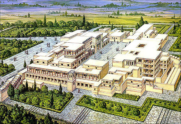
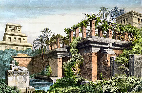
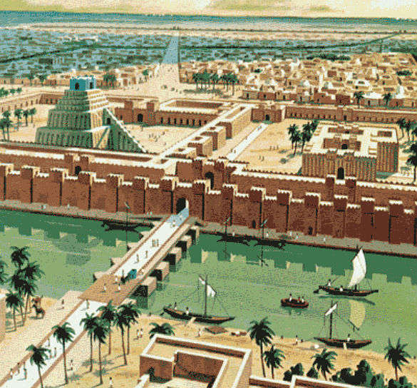
Babylonia
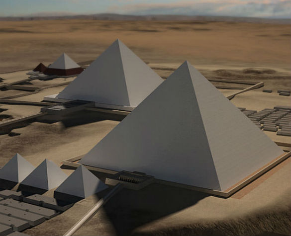
Giza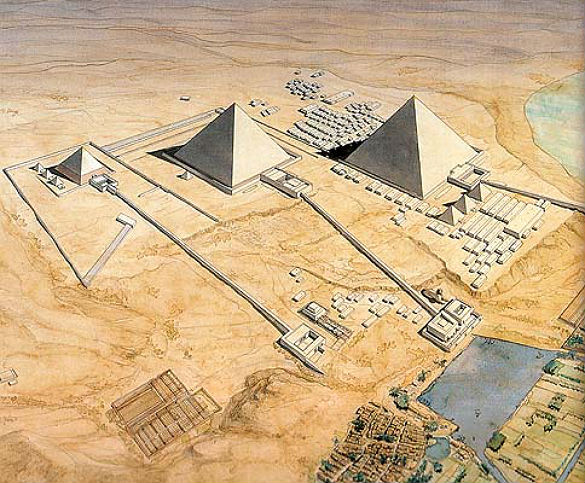
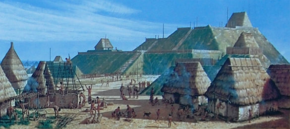
Cahokia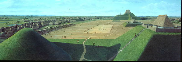
Yaxchilan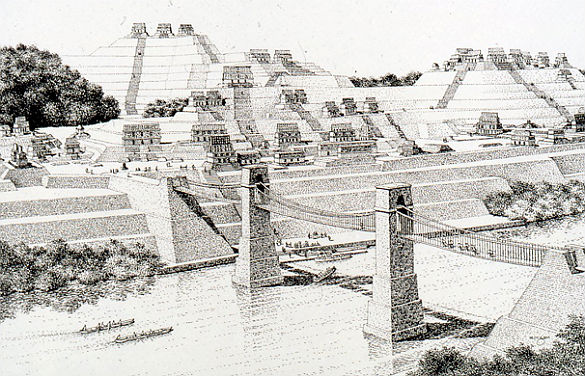
Palenque
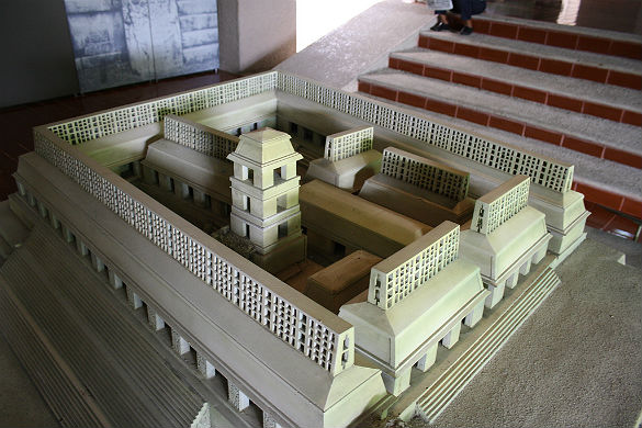
Uxmal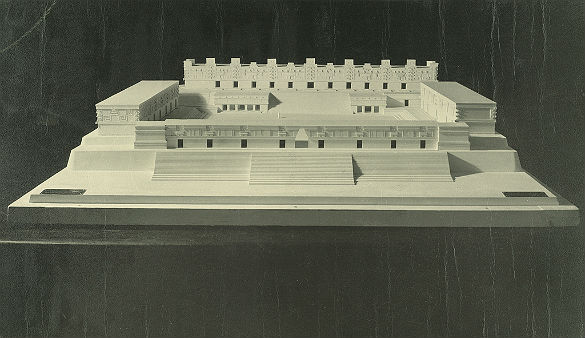
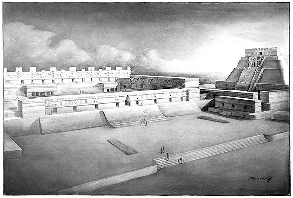
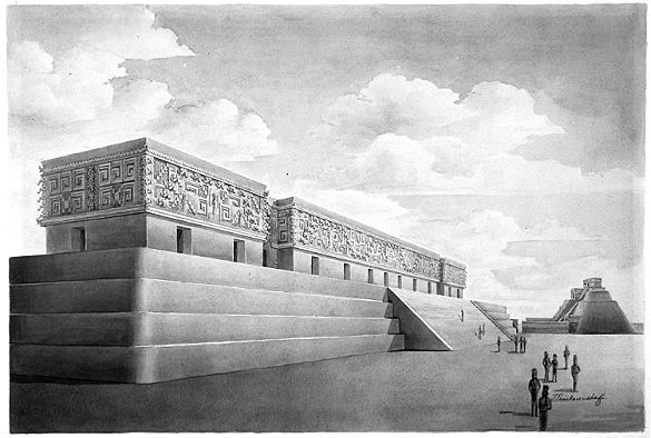
Calakmul
Tikal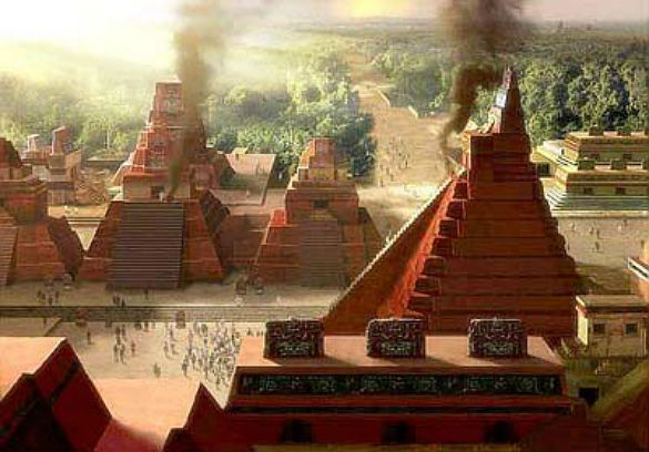
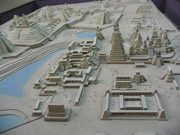
El Mirador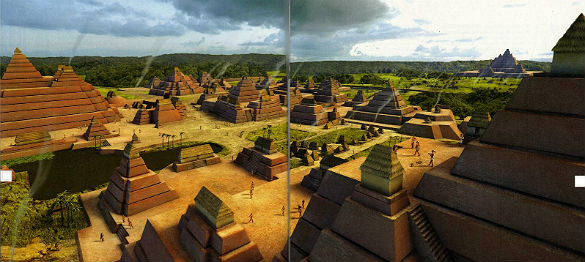
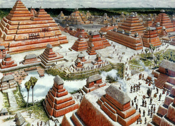
Tenochtitlan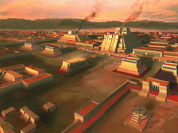
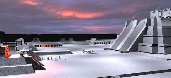
Teotihuacan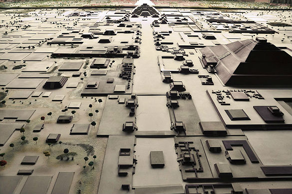
Primitive my butt...
Here are a couple of bonus videos I've made a while back...
Well I hope you enjoyed this trip through time.
Until next time
PEACE
Normally I'll post a location and discuss it's possible origins. Not this time. Earlier today I was talking to a friend of mine and who jokingly asked why I was so interested in a bunch of junky crumbling old ruins. Which to be honest caught me off guard, then I realized that although I see what he and others see I do also in fact see the locations in my minds eye as they once were. To be honest, I get frustrated sometimes having to explain just how sophisticated our ancestors truly were. Hopefully this will get the idea across once and for all that they were many things but not primitive when it came to engineering their Cities, Temples, Empires and other structures.
So, I'll be providing artists renditions and 3d mock ups of how these various ancient cities and cultures would have looked to those who inhabited them. These are some of my favorites from both the old and new world.
Knossos

The name Knossos survives from ancient Greek references to the major city of Crete. The identification of Knossos with the Bronze Age site is supported by tradition and by the Roman coins that were scattered over the fields surrounding the pre-excavation site, then a large mound named Kephala Hill, elevation 85 m (279 ft) from current sea level. Many of them were inscribed with Knosion or Knos on the obverse and an image of a Minotaur or Labyrinth on the reverse, both symbols deriving from the myth of King Minos, supposed to have reigned from Knossos
Babylonia


Babylonia was an ancient Semitic nation state and cultural region based in central-southern Mesopotamia (present-day Iraq). It emerged as an independent state in ca. 1894 BC, the city of Babylon being its capital. Babylonia became the major power in the region after Hammurabi (fl. ca. 1792- 1752 BC middle chronology, or ca. 1696 – 1654 BC, short chronology) created an empire out of the territories of the former Akkadian Empire.
Giza


The Great Pyramid of Giza (also known as the Pyramid of Khufu or the Pyramid of Cheops) is the oldest and largest of the three pyramids in the Giza Necropolis bordering what is now El Giza, Egypt. It is the oldest of the Seven Wonders of the Ancient World, and the only one to remain largely intact. Egyptologists believe that the pyramid was built as a tomb for fourth dynasty Egyptian Pharaoh Khufu (Cheops in Greek) over a 10 to 20-year period concluding around 2560 BCE. Initially at 146.5 metres (481 feet), the Great Pyramid was the tallest man-made structure in the world for over 3,800 years.
Cahokia


Cahokia was the largest and most influential urban settlement in the Mississippian culture which developed advanced societies across much of what is now the Southeastern United States, beginning more than 500 years before European contact. Cahokia's population at its peak in the 1200s was as large, or larger, than any European city of that time, and its ancient population would not be surpassed by any city in the United States until about the year 1800. Today, Cahokia Mounds is considered the largest and most complex archaeological site north of the great Pre-Columbian cities in Mexico.
Yaxchilan

Yaxchilan (also sometimes historically referred to by the names Menché and City Lorillard) is an ancient Maya city located on the bank of the Usumacinta River in what is now the state of Chiapas, Mexico. In the Late Classic Period Yaxchilan was one of the most powerful Maya states along the course of the Usumacinta, with Piedras Negras as its major rival
Palenque

Palenque (Bàak' in Modern Maya) was a Maya city state in southern Mexico that flourished in the 7th century. The Palenque ruins date back to 226 BC to its fall around 1123 AD. After its decline, it was absorbed into the jungle, which is made up of cedar, mahogany, and sapodilla trees, but has been excavated and restored and is now a famous archaeological site attracting thousands of visitors. It is located near the Usumacinta River in the Mexican state of Chiapas
Uxmal


Uxmal (Yucatec Maya: Óoxmáal [óˑʃmáˑl]) is an ancient Maya city of the classical period. Today it is one of the most important archaeological sites of Maya culture, along with those of Caracol, Xunantunich, Chichen Itza and Tikal. It is located in the Puuc region and is considered one of the Maya cities most representative of the region's dominant architectural style.
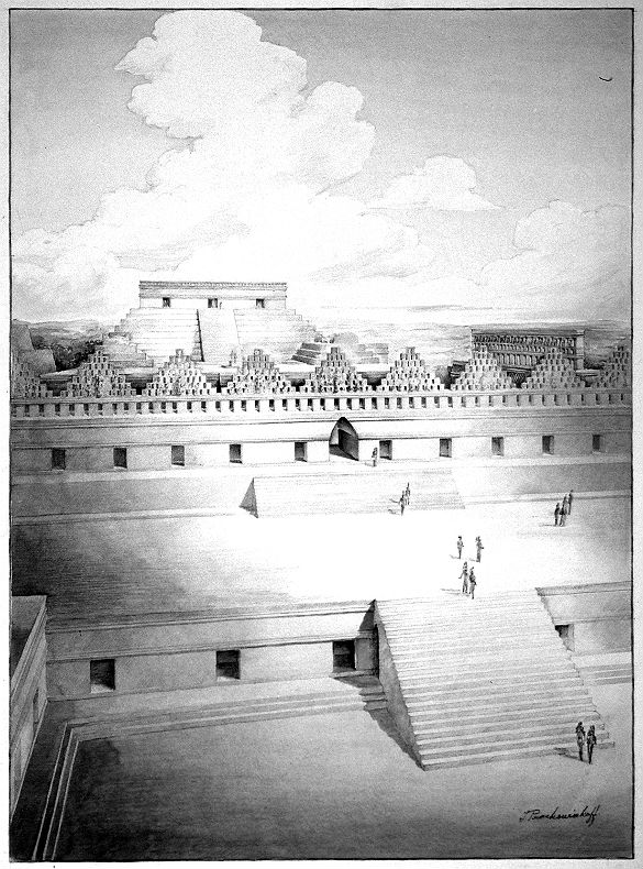
Calakmul

Calakmul (also Kalakmul and other less frequent variants) is a Maya archaeological site in the Mexican state of Campeche, deep in the jungles of the greater Petén Basin region. It is 35 kilometres (22 mi) from the Guatemalan border. Calakmul was one of the largest and most powerful ancient cities ever uncovered in the Maya lowlands. Calakmul is a modern name; in ancient times the city core was known as Ox Te' Tuun.
Tikal


Tikal (or Tik’al according to the modern Mayan orthography) is one of the largest archaeological sites and urban centres of the pre-Columbian Maya civilization. It is located in the archaeological region of the Petén Basin in what is now northern Guatemala. Situated in the department of El Petén, the site is part of Guatemala's Tikal National Park and in 1979 it was declared a UNESCO World Heritage Site.
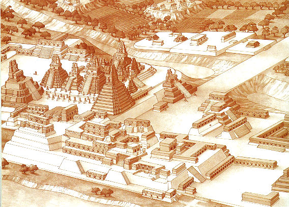
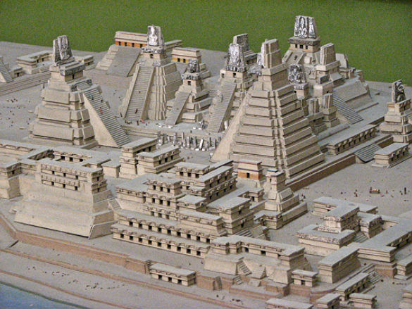
El Mirador


El Mirador was first discovered in 1926, and was photographed from the air in 1930, but the remote site deep in the jungle had little more attention paid to it until Ian Graham spent some time there making the first map of the area in 1962.[1] A detailed investigation was begun in 1978 with an archaeological project under the direction of Dr. Bruce Dahlin (Catholic University of America) and Dr. Ray Matheny (Brigham Young University). Dahlin's work focused primarily on the bajo swamps and mapping, while Matheny's team focused primarily on excavations in the site center and architecture. This project ended in 1983. To the surprise of the archaeologists, it was found that a large amount of construction was not contemporary with the large Maya classic cities in the area, like Tikal and Uaxactun, but rather from centuries earlier in the Pre-Classic era
Tenochtitlan


Tenochtitlan (Classical Nahuatl: Tenōchtitlan [tenoːt͡ʃˈtit͡ɬan]) was a Nahua altepetl (city-state) located on an island in Lake Texcoco, in the Valley of Mexico. Founded in 1325, it became the capital of the expanding Meixca Empire in the 15th century,[1] until captured by the Spanish in 1521. At its peak, it was the largest city in the Pre-Columbian New World. When paired with Mexico the name is a reference to Mexica, the people of the surrounding Aztec heartland. It subsequently became a cabecera of the Viceroyalty of New Spain. Today the ruins of Tenochtitlan are located in the central part of Mexico City.
Teotihuacan

Teotihuacán, is an enormous archaeological site in the Basin of Mexico, just 30 miles (48 km) northeast of Mexico City, containing some of the largest pyramidal structures built in the pre-Columbian Americas. The name means "where man met the gods." Apart from the pyramidal structures, Teotihuacan is also known for its large residential complexes, the Avenue of the Dead, and numerous colorful, well-preserved murals. Additionally, Teotihuacan produced a thin orange pottery style that spread through Mesoamerica.[2] The city is thought to have been established around 100 BC
Primitive my butt...
Here are a couple of bonus videos I've made a while back...
Well I hope you enjoyed this trip through time.
Until next time
PEACE
edit on 12-12-2012 by SLAYER69 because: (no reason given)
reply to post by SLAYER69
although your on my rival list, i have to give you props for this thread indeed. very nice
I could be wrong but I remember reading somewhere that the top of the Pyramids where of a very bright white color that shined in the night....
although your on my rival list, i have to give you props for this thread indeed. very nice
I could be wrong but I remember reading somewhere that the top of the Pyramids where of a very bright white color that shined in the night....
reply to post by SLAYER69
Great thread Slayer! I was reading about Xumal yesterday, but I've always lived the Giza complex, Knossos, and Babylon; can't forget the beast can we? SnF mate.
Great thread Slayer! I was reading about Xumal yesterday, but I've always lived the Giza complex, Knossos, and Babylon; can't forget the beast can we? SnF mate.
reply to post by BacknTime
The outside of the rocks were covered in quartz I believe. I could be wrong. However I did hear that the capstone was supposed to be made out of crystal as well.
The outside of the rocks were covered in quartz I believe. I could be wrong. However I did hear that the capstone was supposed to be made out of crystal as well.
edit on 12-12-2012 by VeritasAequitas because: (no reason given)
Another wonderful thread Slayer
Going to give it the full " Spiegle " now.
Thanks for posting.
SS
reply to post by BacknTime
I'm glad you enjoyed the presentation.
P.S.
Even after being here at ATS for years I've yet to add anybody to my rival/foe list.
No point in my opinion.
Getting too old for that sort of behavior.
I'm glad you enjoyed the presentation.
P.S.
Even after being here at ATS for years I've yet to add anybody to my rival/foe list.
No point in my opinion.
Getting too old for that sort of behavior.
Originally posted by BacknTime
reply to post by SLAYER69
although your on my rival list, i have to give you props for this thread indeed. very nice
This, this is the funniest thing I've read in ages, secondly I checked your profile and Slayer69 isn't on there but someone called neo96*
Just wow...
SS
reply to post by SLAYER69
If only time travel was possible, hey?
Brilliant masterpieces, made by master builders. Will we ever build them again that way?
I wonder......
S&F
If only time travel was possible, hey?
Brilliant masterpieces, made by master builders. Will we ever build them again that way?
I wonder......
S&F
reply to post by SLAYER69
Awesome thread, once again, Slayer!
The similarities between all of those culturally and regionally disparate ancient civilizations - the walls, pyramids, layout of streets... It's almost as if they were all calling upon the same blueprint. Hrm... Wonder what such disparate cultures would have in common to draw upon?
Maybe this ain't our first global rodeo and they were all working from the same memories?
S&F!
~Heff
edit on 12/12/12 by Hefficide because: clarity
reply to post by SLAYER69
How often do you wish you could time travel and explore these places as they were at the height of their grandeur? I think about that all the time as I lay in bed waiting for sleep to take me. I also think I am white and many of these people might treat me like a God allowing me full access!!!!
How often do you wish you could time travel and explore these places as they were at the height of their grandeur? I think about that all the time as I lay in bed waiting for sleep to take me. I also think I am white and many of these people might treat me like a God allowing me full access!!!!
If time travel was possible I'd go back to see puma punku and the Giza pyramids being built and to kick the guy who thought up the idea of burning of
the Library of Alexandria right in the privates
Twice.
Twice.
reply to post by SLAYER69
Agree.
The Pyramids of Giza, and I would like to see Rome also. Angkor in its Prime.
Agree.
The Pyramids of Giza, and I would like to see Rome also. Angkor in its Prime.
Originally posted by SLAYER69
If time travel was possible I'd go back to see puma punku and the Giza pyramids being built and to kick the guy who thought up the idea of burning of the Library of Alexandria right in the privates
Twice.
Sigh. If only. Slightly OT, but I wish I could time travel and swim in the pre-historic oceans (in some advanced safe bubble).
reply to post by SLAYER69
Slayer
Now that is cool, shows the ancient world Industrial centers and a few of their homes at their best. This really sums up Chris Jordan's Ancient Solar Premise, it shows the global nature of the idea better than his work.
Will
Slayer
Now that is cool, shows the ancient world Industrial centers and a few of their homes at their best. This really sums up Chris Jordan's Ancient Solar Premise, it shows the global nature of the idea better than his work.
Will
edit on 12-12-2012 by will2learn because: Why its an industrial landscape
reply to post by SLAYER69
I totally concur,
I would like to travel the Roman empire in it's prime, Rome first, north Africa, Gaul and finally Britannia...


source

We can dream right? For now at least we have Slayer threads.
SS
edit: changed image.
I totally concur,
I would like to travel the Roman empire in it's prime, Rome first, north Africa, Gaul and finally Britannia...


A 19th Century rendering of the west end of the Roman Forum showing from left to right; the Basilca Julia with two story arches, The Temples of Saturn, Vespasian and Concord; with the Arch of Septimus Serverus on the right. In front of "Arch" is a naval monument adorned with the ramming prows (rostra) of enemy ships. In the center, is the "Rostra" platform, from which speeches were delivered.
source

We can dream right? For now at least we have Slayer threads.
SS
edit: changed image.
edit on 023131p://am3116 by Spike Spiegle because: changed pic
edit on 033131p://am3152 by Spike Spiegle
because: more pics
reply to post by SLAYER69
I'd probably run in for the double tap; Theosophists consider the burning of the Library of Alexandria to be one of the most heinous crimes to take place in the history of humanity.
I'd probably run in for the double tap; Theosophists consider the burning of the Library of Alexandria to be one of the most heinous crimes to take place in the history of humanity.
reply to post by Spike Spiegle
I left quite a few out on purpose I didn't want to hog up all the cool cities so others could post their favorites
Thanks for Rome. That would have been cool to have seen in it's Glory
I left quite a few out on purpose I didn't want to hog up all the cool cities so others could post their favorites
Thanks for Rome. That would have been cool to have seen in it's Glory
edit on 12-12-2012 by SLAYER69 because: (no reason given)
Well I thought some here would appreciate seeing the world the ancients lived in through their eyes when those locations were not crumbly ruins.
reply to post by SLAYER69
Blasphemy!!!
I've found that some people just can't see past what's in front of them. I take photo's of old houses and ruins I run across in the backwoods of where I live. Some are in pretty bad shape because they're so dilapidated. But I see what those old places used to look like in their heyday. I think about their history, and what they have seen. I guess it takes a certain type of person... which ATS seems to have an abundance of.
Earlier today I was talking to a friend of mine and who jokingly asked why I was so interested in a bunch of junky crumbling old ruins.
Blasphemy!!!
I've found that some people just can't see past what's in front of them. I take photo's of old houses and ruins I run across in the backwoods of where I live. Some are in pretty bad shape because they're so dilapidated. But I see what those old places used to look like in their heyday. I think about their history, and what they have seen. I guess it takes a certain type of person... which ATS seems to have an abundance of.
new topics
-
DC Votes
US Political Madness: 19 minutes ago -
DOJ moving to wind down Trump criminal cases before he takes office
Mainstream News: 1 hours ago -
About that ''Iron Dome''
Other Current Events: 5 hours ago -
Mother Sentenced to over 2 years for Shouting at police During Disorder
Social Issues and Civil Unrest: 5 hours ago -
Kamala Address the Nation -- Nov 6 2024 4pm EST
2024 Elections: 5 hours ago -
Now Trumps No War policy
2024 Elections: 7 hours ago -
A Face in the Crowd: Reboot
Short Stories: 7 hours ago -
On Nov. 5th 2024 - AMERICANS Prevented the Complete Destruction of America from Within.
2024 Elections: 8 hours ago -
Here we are
General Chit Chat: 10 hours ago -
Conservative women: Your sisters need your help
2024 Elections: 11 hours ago
top topics
-
On Nov. 5th 2024 - AMERICANS Prevented the Complete Destruction of America from Within.
2024 Elections: 8 hours ago, 25 flags -
Where is Kamala?
US Political Madness: 12 hours ago, 22 flags -
Now, what about the sentencing in Trump's trial?
US Political Madness: 12 hours ago, 21 flags -
Conservative women: Your sisters need your help
2024 Elections: 11 hours ago, 14 flags -
Why Trump Won
Politicians & People: 13 hours ago, 11 flags -
Kamala Address the Nation -- Nov 6 2024 4pm EST
2024 Elections: 5 hours ago, 9 flags -
Now Trumps No War policy
2024 Elections: 7 hours ago, 7 flags -
DOJ moving to wind down Trump criminal cases before he takes office
Mainstream News: 1 hours ago, 6 flags -
A Face in the Crowd: Reboot
Short Stories: 7 hours ago, 5 flags -
Mother Sentenced to over 2 years for Shouting at police During Disorder
Social Issues and Civil Unrest: 5 hours ago, 4 flags
active topics
-
A Face in the Crowd: Reboot
Short Stories • 6 • : BingoMcGoof -
No links No news source Just a message WE MADE IT TRUMP WON!!
Breaking Alternative News • 74 • : Astrocometus -
On Nov. 5th 2024 - AMERICANS Prevented the Complete Destruction of America from Within.
2024 Elections • 65 • : awhispersecho -
DC Votes
US Political Madness • 5 • : Athetos -
About that ''Iron Dome''
Other Current Events • 15 • : BingoMcGoof -
Kamala Address the Nation -- Nov 6 2024 4pm EST
2024 Elections • 54 • : xuenchen -
A different look at freewill
Philosophy and Metaphysics • 97 • : KnowItAllKnowNothin -
DOJ moving to wind down Trump criminal cases before he takes office
Mainstream News • 7 • : theatreboy -
Mother Sentenced to over 2 years for Shouting at police During Disorder
Social Issues and Civil Unrest • 16 • : stelth2 -
Witches Finding It Too Hard to Cast Spells Against Trump Because of Some 'Protection'
ATS Skunk Works • 83 • : Astrocometus


