It looks like you're using an Ad Blocker.
Please white-list or disable AboveTopSecret.com in your ad-blocking tool.
Thank you.
Some features of ATS will be disabled while you continue to use an ad-blocker.

"Nazca Line" looking lines close to Georgia Guidestones, what are they?
page: 1share:
While reading about the Georgia Guidestones and searching around the area a bit in Google Earth I found something which I was wondering if anyone
might know what purpose of these lines/trails/roads might be.
One of the biggest question to me is who had the Guidestones built, I figured who ever it was probably lives close to the area and started snooping around.
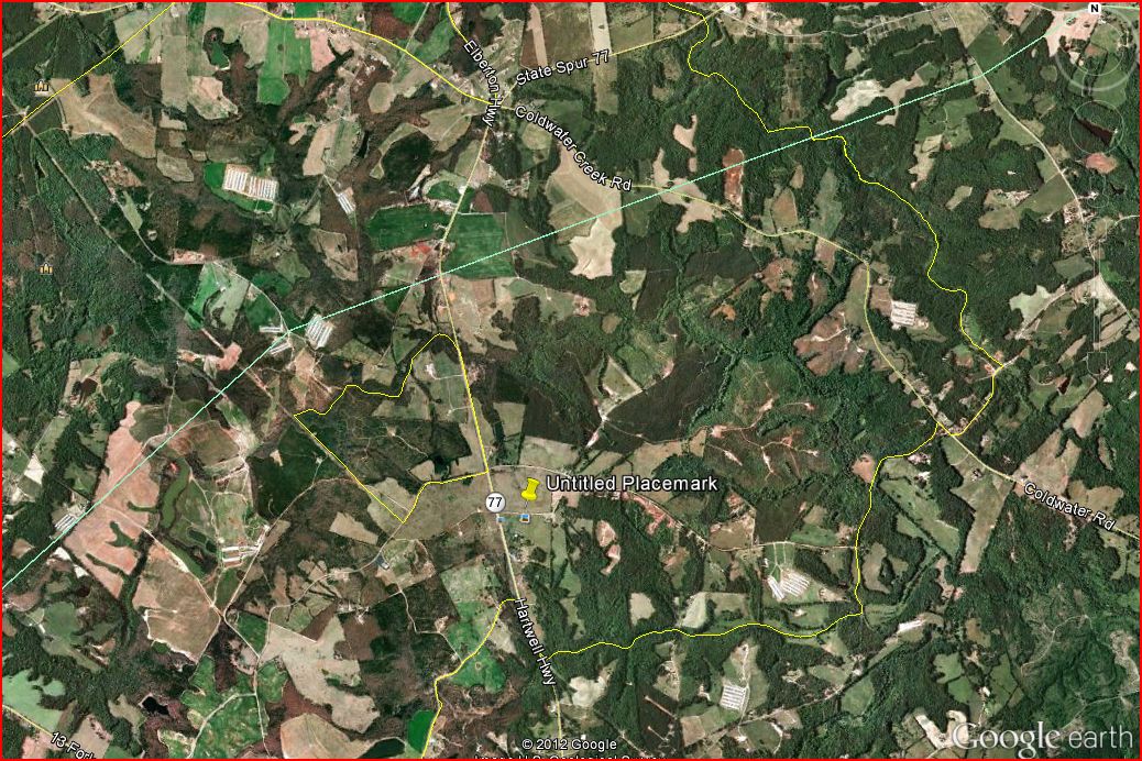
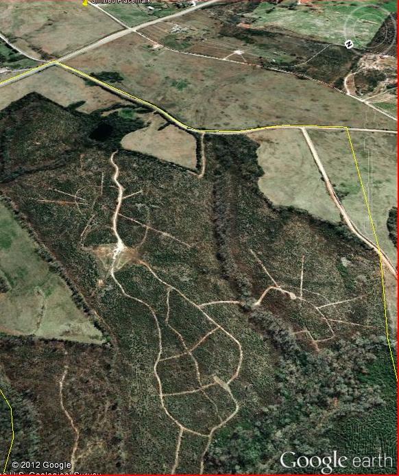
On the above map, the yellow thumbtack is placed directly north of the Guidestones by me. The yellow lines you see on the map are generated by Google earth under Layers>More>US Government>Postal Code Boundaries. The area I am calling attention to is north west of the Guidestones that is outlined in yellow. Also seen from a further away view directly to the left of the yellow thumbtack inside area code 30634 or Dewy Rose, GA.
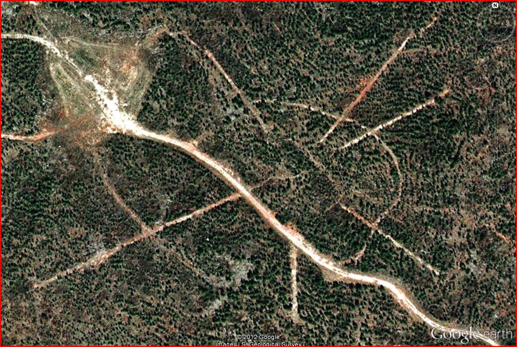
Zooming in further we can see inside the small zip code, there are 3 structures I circled in red, I also circled the Guidestones at the bottom of the picture.
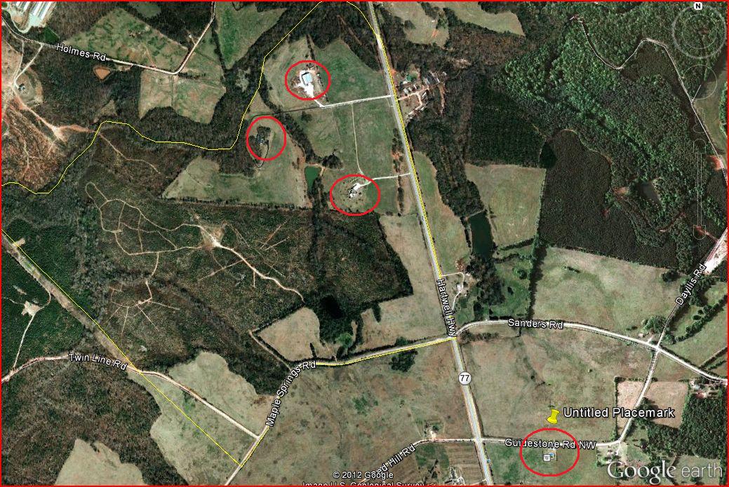
Of the 3 top structures the bottom 2 appear to be homes and the northern one appears to be a barn or workshop of some sort. To the west of them is some forest that appears to have some sort of trails through going through it. Scroll photo to the right to see all of the area.
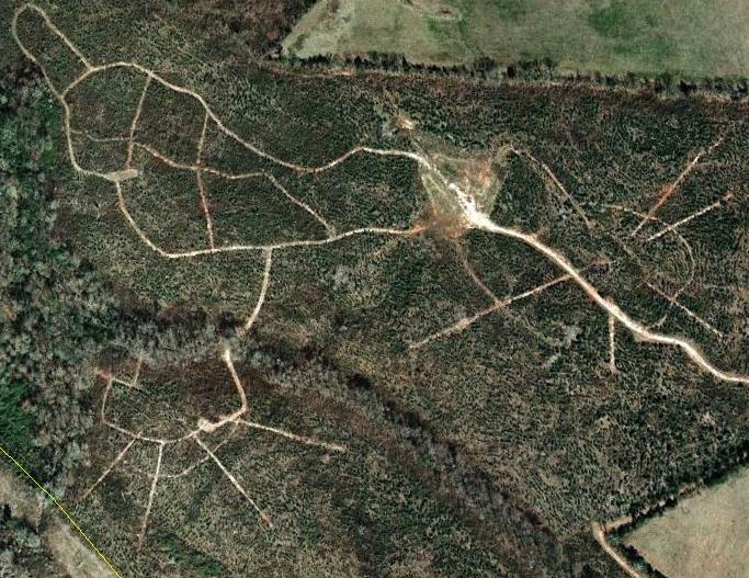
To be seen from this distance, these are not walking trails these were wore down by vehicles or earth moving equipment. The thing that most draws my attention are the lines that start and stop from nothing and are only touched by another trail somewhere in the middle of that line. Again, Scroll photo to the right to see all of the area.
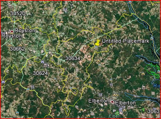
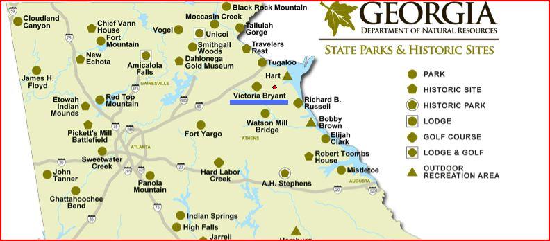
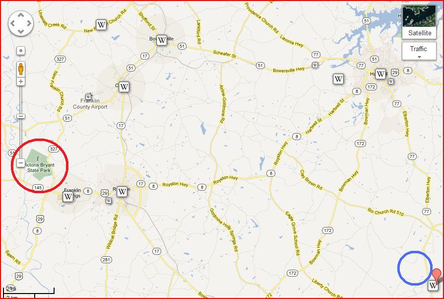
I can't quite understand what purpose these lines serve. I was thinking maybe this area was a State Park but the closest park is Victoria Bryant State Park Underlined in blue on the map below.
The Red dot above the "a" in Bryant is where I place the area with the lines, although it could be closer. Below on the left circled in red is Victoria Bryant State Park and to the right the other area in blue, have to scroll pic to the right to see.
So the questions are what is the small zip code and why is it there? Who are the people that live there? What is the purpose of the trails in the forest and what are those lines that end and begin from no where. Here is a shot looking South East from the lines towards the Guidestones, you can see the yellow thumbtack at the top of the picture.
I have been unable to figure out what zipcode the area is or the addresses of the homes in it.
One of the biggest question to me is who had the Guidestones built, I figured who ever it was probably lives close to the area and started snooping around.
On the above map, the yellow thumbtack is placed directly north of the Guidestones by me. The yellow lines you see on the map are generated by Google earth under Layers>More>US Government>Postal Code Boundaries. The area I am calling attention to is north west of the Guidestones that is outlined in yellow. Also seen from a further away view directly to the left of the yellow thumbtack inside area code 30634 or Dewy Rose, GA.
Zooming in further we can see inside the small zip code, there are 3 structures I circled in red, I also circled the Guidestones at the bottom of the picture.
Of the 3 top structures the bottom 2 appear to be homes and the northern one appears to be a barn or workshop of some sort. To the west of them is some forest that appears to have some sort of trails through going through it. Scroll photo to the right to see all of the area.
To be seen from this distance, these are not walking trails these were wore down by vehicles or earth moving equipment. The thing that most draws my attention are the lines that start and stop from nothing and are only touched by another trail somewhere in the middle of that line. Again, Scroll photo to the right to see all of the area.
I can't quite understand what purpose these lines serve. I was thinking maybe this area was a State Park but the closest park is Victoria Bryant State Park Underlined in blue on the map below.
The Red dot above the "a" in Bryant is where I place the area with the lines, although it could be closer. Below on the left circled in red is Victoria Bryant State Park and to the right the other area in blue, have to scroll pic to the right to see.
So the questions are what is the small zip code and why is it there? Who are the people that live there? What is the purpose of the trails in the forest and what are those lines that end and begin from no where. Here is a shot looking South East from the lines towards the Guidestones, you can see the yellow thumbtack at the top of the picture.
I have been unable to figure out what zipcode the area is or the addresses of the homes in it.
hi, they're logging marks from dragging them up the hill.....that should be a 90 foot high one with the radial marks
edit on 4-6-2012 by
GBP/JPY because: Yahushua...our new King
What's the purpose of these lines?
Where I'm from they're used for transportation.
I think you are reading too much into the landscape.
Where I'm from they're used for transportation.
I think you are reading too much into the landscape.
Elberton GA is like the stone capital of the South. These lines may be quarry sites where they get the stone. Just a thought.
A little off the Nasca Line subject:
I too was interested about the Georgia Guidestones and did a little research awhile back. I was curious to who paid the taxes. The Elberton County was given the 5 acre plot pretty much after it was finished being built. So the county now owns the property which is of course tax exempt. For this to be a legal transaction I would say that they really do know who this R.C. Christian dude is and for some reason are not disclosing it.
Mr. Christian went to Pyramid Construction and had them organize and build the Guidestones. They too probably have some kind of record on who the mysterious person really was. He spent a little over a million with them for the project so they have to know something about who he really was through the money transactions.
I don't know if those lines are relevant to the Guidestones but I won't totally dismiss it. I just thought he chose the site because it was close to where they got the stone from.
I think the Guidestones are Masonic.
I don't say this to get a rise out of the Masons. This is just what I believe.
I don't say this to get a rise out of the Masons. This is just what I believe.
It's rather wooded and those are some nice homes in that area. Looks like a private golf course.
What's the exact zip code? I could check if it's a disc golf course, but it might be a private one of those as well.
What's the exact zip code? I could check if it's a disc golf course, but it might be a private one of those as well.
These are not called "Nazca lines", these are called "roads" and maybe used for logging and transporting the trees away. The "race circuit"
pattern has been there as far as GE reaches back, the small thingy with the four little roads extending to the south west was added in 2007.
There's a dairy farm to the west and a lot of small farms surrounding the area. My bucks are on tree logging or other types of agricultural use. The road to the south east is called Maple Springs road, maybe that's a hint.
Sorry no mystery here.
There's a dairy farm to the west and a lot of small farms surrounding the area. My bucks are on tree logging or other types of agricultural use. The road to the south east is called Maple Springs road, maybe that's a hint.
Sorry no mystery here.
Originally posted by Tazkven
reply to post by DaTroof
I could not find the zip code for that area ...
I see. Well, I think the other user above may have nailed it down. Those could be pecan trees or peach trees, or simply maples cut for timber. Without driving there and finding out, the best we can do is guess.
If anyone likes to solve a little mystery .. and who doesn't .. follow Holmes Road to the north and check out the small farm that is on the corner to
Parks Brown Road.
Can anyone tell me why they have like .. 200 cars parked on their property ? Is there a government bunker below ? lol
Can anyone tell me why they have like .. 200 cars parked on their property ? Is there a government bunker below ? lol
I have been to that area. It is a farming community. There is logging and a lot of other large farm machinery that roams that area.
reply to post by DaTroof
I know nothing about logging, was curious what it was as that whole area stood out to me, of course it could be nothing or could be something, of course there are trees gone, that much is obvious ... I always thought loggers took entire areas not ride into the middle of an area and start cutting out lines but I'm no logger as I said before ...
I know nothing about logging, was curious what it was as that whole area stood out to me, of course it could be nothing or could be something, of course there are trees gone, that much is obvious ... I always thought loggers took entire areas not ride into the middle of an area and start cutting out lines but I'm no logger as I said before ...
reply to post by Tazkven
Also curious how they got the logging trucks around the 90 degree corners without rounding out the road, unless they drug the trees to the main road or took out the timber on pickup trucks ...
Even dragging the timber would seem that once you hit the corners, they would be "rounded" not 90 degree sharp corners
edit on 4-6-2012 by Tazkven because: (no reason given)
reply to post by Attrei
My girl friend was talking about going to the Casinos in Cherokee for vacation, the thought crossed my mind to stop by there and see, lol. Course I did not tell her that
If you scan around that area with satellite view some of the homes around there are a little more than farm houses and well hidden but not from the air. The two houses with in that small zip code are pretty big.
edit on 4-6-2012 by Tazkven because: (no reason given)
Originally posted by disgustingfatbody
What's the purpose of these lines?
Where I'm from they're used for transportation.
Yeah. Dirt bikes. These look like dirt bike trails somebody has made along the paths where there used to be old logging roads or trails. Of course they're going to look like that.
My money after thirty odd years of logging contracting is on skid trails for pulling the trees out of the bush...look for a place or two where the
lines may hit an open area, and i bet thats your "landings" where the trucks load....
there should be a better road out to somewhere in the mix........my 2 cts....
On looking back, there is a well used landing in the gib block....where the most bush is encompassed...the lines are the marks of the loader and skidding machines turning around over many days or even weeks....
The bigger lines leaving the area are the "haul roads"
If you can zoom further down without too much pixilation ou probaby can see where they parked (the trucks)to load and where they piled the trimmed logs to be loaded just by the pattern of the tracks....
Just looking makes me homesick for the bush.......
edit on 4-6-2012 by stirling because: (no reason given)
reply to post by stirling
I have no doubts some logging took place here, the thing that stood out to me most are the lines with no beginning or end, I guess there is a reason they did that but I have no idea and is why I asked. Also on the route out there are 2 90 degree turns, seems less then optimal for a semi truck hauling timber.
The only reason I called these "nazca line" is because that's what they reminded me of, I wasn't saying they were nazca lines, thats why I said "nazca line" looking lines. That small zip code area, what ever it is, intrigues me as well, why is such a small area have a different zip code with only two homes in it and why ? Maybe I should had named the topic as such ...
HMMMM, the other anomalies seem more out of place than the lines....
Two houses have their own postal code?
Cant make head nor tails of that.......something sinister maybe?
Two houses have their own postal code?
Cant make head nor tails of that.......something sinister maybe?
reply to post by stirling
Yea, I actually meant for it all to be considered together but because of the way I titled the thread everyone concentrated on just the lines, which honestly did intrigue me but I am not a logger.
I have tried to get info on those homes, addresses, taxes paid, home value ... even the zip code of that small area but came up with nothing.
new topics
-
President Bidens Health is Declining Faster 5.8.2024 - He Should Stay Home.
2024 Elections: 49 minutes ago -
Court of Appeals Agrees to Hear Trump Appeal to Flush Fani Willis
US Political Madness: 1 hours ago -
I "lost" a manuscript.
Rant: 4 hours ago -
Crocodile Reported in Water near a Buckinghamshire village in the UK
Pets: 4 hours ago -
Chris Cuomo, who pushed vaccine shots on CNN, admits Moderna vaccine destroyed his health
Mainstream News: 7 hours ago -
History Shows; Many Crisis Are Artificial I'm Order To Enslave People
Political Conspiracies: 7 hours ago
top topics
-
StormyD Accused of Falsification of Business Records to Hide Money From Trump
US Political Madness: 17 hours ago, 23 flags -
Chris Cuomo, who pushed vaccine shots on CNN, admits Moderna vaccine destroyed his health
Mainstream News: 7 hours ago, 19 flags -
Crocodile Reported in Water near a Buckinghamshire village in the UK
Pets: 4 hours ago, 6 flags -
History Shows; Many Crisis Are Artificial I'm Order To Enslave People
Political Conspiracies: 7 hours ago, 4 flags -
I "lost" a manuscript.
Rant: 4 hours ago, 3 flags -
Court of Appeals Agrees to Hear Trump Appeal to Flush Fani Willis
US Political Madness: 1 hours ago, 3 flags -
President Bidens Health is Declining Faster 5.8.2024 - He Should Stay Home.
2024 Elections: 49 minutes ago, 2 flags
active topics
-
Court of Appeals Agrees to Hear Trump Appeal to Flush Fani Willis
US Political Madness • 4 • : pianopraze -
Chris Cuomo, who pushed vaccine shots on CNN, admits Moderna vaccine destroyed his health
Mainstream News • 43 • : Anunak -
Israeli strikes on southern Gaza city of Rafah kill 22, mostly children, as US advances aid package
Middle East Issues • 187 • : cherokeetroy -
-@TH3WH17ERABB17- -Q- ---TIME TO SHOW THE WORLD--- -Part- --44--
Dissecting Disinformation • 876 • : Thoughtful3 -
NASA Black Hole Visualization - Go Beyond the Brink
Space Exploration • 9 • : LSU2018 -
Breaking--Hamas Accepts New Cease Fire
Middle East Issues • 288 • : Oldcarpy2 -
President Bidens Health is Declining Faster 5.8.2024 - He Should Stay Home.
2024 Elections • 1 • : Zanti Misfit -
Modern Mind Control
General Conspiracies • 56 • : whereislogic -
The Acronym Game .. Pt.3
General Chit Chat • 7811 • : F2d5thCavv2 -
The Impeachment Inquiry of U.S. President Joseph R. Biden - Charges and Developments.
Political Issues • 431 • : WeMustCare