It looks like you're using an Ad Blocker.
Please white-list or disable AboveTopSecret.com in your ad-blocking tool.
Thank you.
Some features of ATS will be disabled while you continue to use an ad-blocker.

Quake Watch 2012
page: 189share:
I thought some people in the earthquake thread might like a look at the recent seismograph readings from White Island.
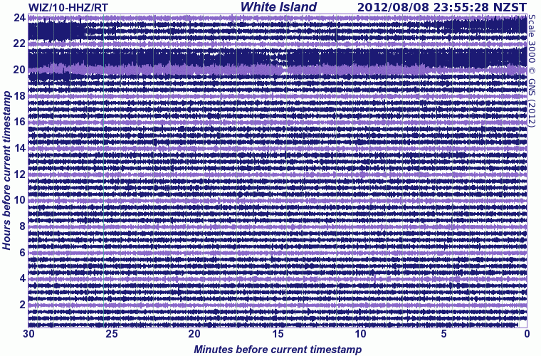
Discussion about the White Island and Tongariro eruptions are on the volcano thread.
Volcanic Alert Bulletin WI-2012/03 - First ash emissions since 2000; Alert Level is at Level 2; Aviation Colour Code is Orange
Around 11:30 pm on August 7 volcanic tremor at White Island sharply decreased to levels seen prior to the current episode of unrest in late July. A few hours after this drop in tremor, the colour of the plume changed from white to light brown, indicating more ash is now in the plume. Visual observations in recent days show that a small cone is being built in the lake, around the main area of degassing.
This is the first time ash has been produced from White Island since 2000 and may represent the start of a new phase of activity at White Island.
Discussion about the White Island and Tongariro eruptions are on the volcano thread.
Missed one
approx 17 hours before the Tongariro Eruption, 116km to the north of Tongariro on the Mamaku Plateau
I got so wrapped up in getting Japan pages going I forgot my own back yard
Can't sleep so did an update.
Few things I spotted
"scientists were taken by surprise by eruption of Tongariro"
maybe they are burnt out from 2 years of Christchurch, 11,000 quakes to find
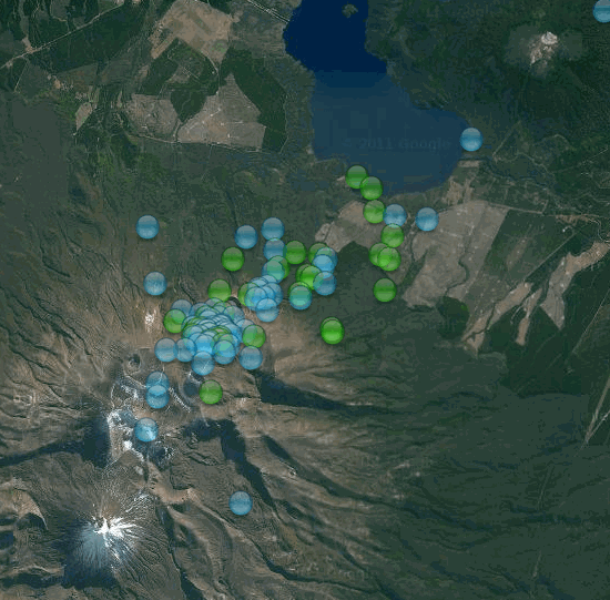
This is a screenshot of Tongariro, last 30 days, methinks there was plenty of warning
The eruption happened at Monday, 6 August 2012 at 11:50:00 a.m. UTC
I can't pin any of the events on the 6th to the time of the eruption, there is only one event on the 6th on the volcano, right spot, right depth, but wrong time, 12 hours after.
same day, 19 hours prior to the eruption, Auckland had its annual mini earthquake swarm in the Hauraki Gulf, NE of Tiritiri Matangi Island. 30.5km NE of NZ's youngest volcano, Rangitoto
links to all the interactive maps are in my signature, but here's the 30 days one set on the Auckland quakes goo.gl...
and one set on Tongariro goo.gl...
(I'll keep the file on Dropbox for 30 days then its gone and you'd have to pick the days individually)
While I have it up on the screen, one set on White Island, nothing in the last 30 days to indicate anything was about to happen goo.gl...
back to sleep hopefully zzzzzzzzzzzzzzz
approx 17 hours before the Tongariro Eruption, 116km to the north of Tongariro on the Mamaku Plateau
5.104-2012/8/6 5:6:38.2
Ref: 3752118
Lat/Long: -38.11599 176.01038
When: 2012/8/6 5:6:38.2 UTC
Depth: 209 km
Mag: 5.104 ML
Location: Galaxy Rd, Kinleith 3491
FEGL Region: Waitomo-Tokoroa-Rotorua
Energy Released: 682.981 tonnes of TNT
Felt: No
I got so wrapped up in getting Japan pages going I forgot my own back yard
Can't sleep so did an update.
Few things I spotted
"scientists were taken by surprise by eruption of Tongariro"
maybe they are burnt out from 2 years of Christchurch, 11,000 quakes to find
This is a screenshot of Tongariro, last 30 days, methinks there was plenty of warning
The eruption happened at Monday, 6 August 2012 at 11:50:00 a.m. UTC
I can't pin any of the events on the 6th to the time of the eruption, there is only one event on the 6th on the volcano, right spot, right depth, but wrong time, 12 hours after.
Ref: 3752474
Lat/Long: -39.11481 175.66425
When: 2012/8/6 22:34:54.1 UTC ( 7 August 2012 at 10:35:00 a.m.NZST)
Depth: 0 km
Mag: 1.672 ML
same day, 19 hours prior to the eruption, Auckland had its annual mini earthquake swarm in the Hauraki Gulf, NE of Tiritiri Matangi Island. 30.5km NE of NZ's youngest volcano, Rangitoto
Lat/Long: -36.53718 175.01762
When: 2012/8/6 3:45:8.7 UTC
Depth: 5 km
Mag: 2.265 ML
Lat/Long: -36.53273 174.99864
When: 2012/8/6 3:57:19.1 UTC
Depth: 9 km
Mag: 2.006 ML
Lat/Long: -36.52859 175.0006
When: 2012/8/6 3:59:58.1 UTC
Depth: 8 km
Mag: 2.357 ML
links to all the interactive maps are in my signature, but here's the 30 days one set on the Auckland quakes goo.gl...
and one set on Tongariro goo.gl...
(I'll keep the file on Dropbox for 30 days then its gone and you'd have to pick the days individually)
While I have it up on the screen, one set on White Island, nothing in the last 30 days to indicate anything was about to happen goo.gl...
back to sleep hopefully zzzzzzzzzzzzzzz
edit on 8-8-2012 by muzzy because: forgot to add the image, then it was too big size for ATS
loading as a PNG, so had to change it to a GIF
I have been monitoring the Earthquakes for the last couple of hours, there was only the one in California registering. Then it showed
this.www.iris.edu...
Originally posted by dreamfox1
Here we go !!!!
Type: Earthquake
2 minutes ago
Magnitude: 4.4
DateTime: Wednesday August 8 2012, 06:23:34 UTC
Region: Greater Los Angeles area, California
Depth: 8.2 km
Source: USGS Feed
Wednesday August 8 2012, 07:05:54 UTC Greater Los Angeles area, California 1.7
Wednesday August 8 2012, 06:48:19 UTC Greater Los Angeles area, California 1.4
Wednesday August 8 2012, 06:41:14 UTC Greater Los Angeles area, California 1.2
Wednesday August 8 2012, 06:24:58 UTC Greater Los Angeles area, California 2.7
Wednesday August 8 2012, 06:24:58 UTC Greater Los Angeles area, California 2.7
**Wednesday August 8 2012, 06:23:34 UTC Greater Los Angeles area, California 4.4 **
edit on 7/30/2012 by dreamfox1 because: .....edit on 7/30/2012 by dreamfox1 because: (no reason given)
On a earlier post I asked where were the aftershocks for the Parkfield earthquake. I see that on this event we do have some activity.
Another 4.5 just hit Greater Los Angeles:
earthquake.usgs.gov...
Hmm, remember only 1 in 20 chance or so it could lead to something bigger, maybe less.
And my googles are telling me we got a bit of a swarm going in that area. A swarm that has escalated now into two 4.5's...
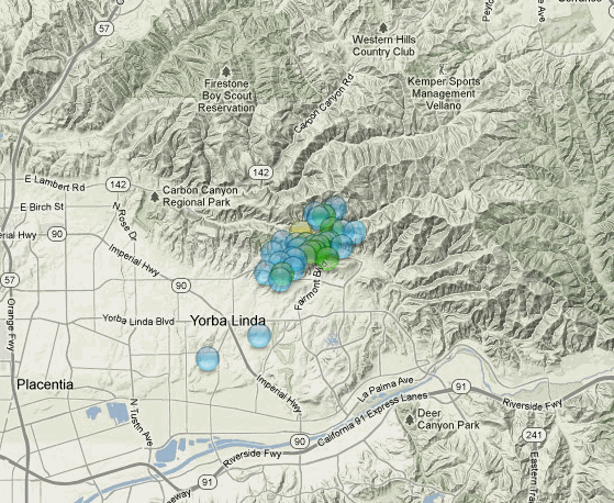
Yep. The swarm is happening right on and near the Whittier fault section of the Elsinore fault zone:
And I think most if not all of those quakes are from today!
earthquake.usgs.gov...
Hmm, remember only 1 in 20 chance or so it could lead to something bigger, maybe less.
And my googles are telling me we got a bit of a swarm going in that area. A swarm that has escalated now into two 4.5's...
Yep. The swarm is happening right on and near the Whittier fault section of the Elsinore fault zone:
And I think most if not all of those quakes are from today!
edit on Wed Aug 8th 2012 by TrueAmerican because: (no reason given)
I got so wrapped up in getting Japan pages going I forgot my own back yard
Can't sleep so did an update.
Few things I spotted
"scientists were taken by surprise by eruption of Tongariro"
maybe they are burnt out from 2 years of Christchurch, 11,000 quakes to find
This is a screenshot of Tongariro, last 30 days, methinks there was plenty of warning
The eruption happened at Monday, 6 August 2012 at 11:50:00 a.m. UTC
I can't pin any of the events on the 6th to the time of the eruption, there is only one event on the 6th on the volcano, right spot, right depth, but wrong time, 12 hours after.
Why were they surprised? the area has been more or less in a constant swarm since that big 7+ quake two or 3 years ago? i was expecting this to happen sooner or later .. yet i feared it would have been the whole caldrea that might erupt.. luck enough it wasnt.. yet
Can't sleep so did an update.
Few things I spotted
"scientists were taken by surprise by eruption of Tongariro"
maybe they are burnt out from 2 years of Christchurch, 11,000 quakes to find
This is a screenshot of Tongariro, last 30 days, methinks there was plenty of warning
The eruption happened at Monday, 6 August 2012 at 11:50:00 a.m. UTC
I can't pin any of the events on the 6th to the time of the eruption, there is only one event on the 6th on the volcano, right spot, right depth, but wrong time, 12 hours after.
Ref: 3752474
Lat/Long: -39.11481 175.66425
When: 2012/8/6 22:34:54.1 UTC ( 7 August 2012 at 10:35:00 a.m.NZST)
Depth: 0 km
Mag: 1.672 ML
Why were they surprised? the area has been more or less in a constant swarm since that big 7+ quake two or 3 years ago? i was expecting this to happen sooner or later .. yet i feared it would have been the whole caldrea that might erupt.. luck enough it wasnt.. yet
edit on 8/8/12 by
alysha.angel because: (no reason given)
reply to post by TrueAmerican
and another
and another
Source
3.4 4km ENE of Yorba Linda, California 2012-08-08 16:51:04 33.904°N 117.772°W 6.7
anyone know of an earthquake that has just hit around the oregon area? Im pickin up the waves from it on GEE, But nothing showing up on any earthquake
sites
reply to post by steve95988
Maybe this
Maybe this
Source
MAP 2.1 2012/08/08 17:46:40 46.313 -124.173 23.6 10 km ( 6 mi) WSW of Long Beach, WA
Originally posted by Anmarie96
reply to post by steve95988
Maybe this
Source
MAP 2.1 2012/08/08 17:46:40 46.313 -124.173 23.6 10 km ( 6 mi) WSW of Long Beach, WA
Somehow i doubt that, It seems to be closer to the coast of oregon, i had mrytle point oregon pulled up in GEE along with yellowstone and numerous s cali stations, and they all received, the P waves eventually, but seems like it originated somewhere off the coast of oregon, i dont see a 2.1 sending p waves across the country
reply to post by steve95988
There was one off Alaska coast earlier this moring. 5.6 60km SW of Sand Point, Alaska
earthquake.usgs.gov...
There was one off Alaska coast earlier this moring. 5.6 60km SW of Sand Point, Alaska
earthquake.usgs.gov...
reply to post by steve95988
Wherever that was, it was much bigger than a Mag 2.1. My guess is it will be relocated out to the Blanco fracture zone, and will be closer to a Mag 5. (just a big guess )
This snapshot of the west coast Transportable Array seismos shows something big enough to register on every station from Canada to northern California. Array Network Snapshot page
Here is the link to the PNSN event page for that Mag 2.1. Notice that it hasn't been reviewed and the location quality is poor. Tricky getting the offshore quakes nailed down.
edit on 8/8/2012 by Olivine because: rewording
edit on 8/8/2012 by Olivine because: (no reason given)
Oregon - GSRAS and GEOFON
www.ceme.gsras.ru/cgi-bin/quake_state.pl?sta=20123041
geofon.gfz-potsdam.de/eqinfo/event.php?id=gfz2012pnhw
USGS, 4.9 mb
earthquake.usgs.gov/earthquakes/recenteqsww/Quakes/usb000bs51.php
earthquake.usgs.gov/earthquakes/eventpage/usb000bs51
www.ceme.gsras.ru/cgi-bin/quake_state.pl?sta=20123041
Earthquake parameters
date= 08-Aug-2012 17:45:34.8 lat= 43.36 lon= -129.8
depth= 20km mb: 5/16
geofon.gfz-potsdam.de/eqinfo/event.php?id=gfz2012pnhw
F-E Region: Off Coast of Oregon
Time: 2012-08-08 17:45:49.4 UTC
Magnitude: 4.4 (mb)
Epicenter: 127.07°W 44.82°N
Depth: 28 km
Status: M - manually revised
USGS, 4.9 mb
earthquake.usgs.gov/earthquakes/recenteqsww/Quakes/usb000bs51.php
earthquake.usgs.gov/earthquakes/eventpage/usb000bs51
edit on 8-8-2012 by wujotvowujotvowujotvo because: (no reason given)
I use this website to watch earthquakes and I have been watching it periodically throughout the year but today more so than usual because of another
thread.... It has shown a lot of activity today....
quakes.globalincidentmap.com...
quakes.globalincidentmap.com...
reply to post by belindamck
over the last 3 hours this website has listed around 25 eq for the US coast line....
over the last 3 hours this website has listed around 25 eq for the US coast line....
Pressure went south
Type: Earthquake
17 minutes ago
Magnitude: 5
DateTime: Thursday August 9 2012, 02:34:39 UTC
Region: Revilla Gigedo Islands Region
Depth: 10 km
Source: CSEM-EMSC Feed
quakes.globalincidentmap.com...
This is dangerous in a way .....
Lots of displacement in a very short time
Type: Earthquake
17 minutes ago
Magnitude: 5
DateTime: Thursday August 9 2012, 02:34:39 UTC
Region: Revilla Gigedo Islands Region
Depth: 10 km
Source: CSEM-EMSC Feed
quakes.globalincidentmap.com...
This is dangerous in a way .....
Lots of displacement in a very short time
edit on 7/30/2012 by dreamfox1 because: (no reason given)
edit on 7/30/2012 by
dreamfox1 because: Type: Earthquake 23 minutes ago Magnitude: 5.6 DateTime: Thursday August 9 2012, 02:34:46 UTC Region: Revilla Gigedo Islands region
Depth: 38.5 km Source: USGS Feed
they are popping off all along the coast last two days.
4.5 2012/08/09 04:18:19 44.574 -129.595 10.0 OFF THE COAST OF OREGON
2.6 2012/08/08 23:27:16 38.833 -122.880 2.6 NORTHERN CALIFORNIA
2.6 2012/08/08 19:22:13 33.903 -117.784 8.7 GREATER LOS ANGELES AREA, CALIFORNIA
4.9 2012/08/08 17:45:33 44.431 -128.639 10.0 OFF THE COAST OF OREGON
2.8 2012/08/08 17:36:26 33.904 -117.781 9.1 GREATER LOS ANGELES AREA, CALIFORNIA
3.4 2012/08/08 16:51:04 33.901 -117.789 9.5 GREATER LOS ANGELES AREA, CALIFORNIA
4.5 2012/08/08 16:33:22 33.904 -117.789 9.7 GREATER LOS ANGELES AREA, CALIFORNIA
2.6 2012/08/08 08:50:45 40.128 -122.762 10.5 NORTHERN CALIFORNIA
4.5 2012/08/08 06:23:34 33.907 -117.790 10.4 GREATER LOS ANGELES AREA, CALIFORNIA
2.7 2012/08/08 02:56:56 41.160 -123.396 40.0 NORTHERN CALIFORNIA
USGS info
I'm usually pretty critical of USGS, but I guess they do do the best coverage of the United States when all is said and done about poor reports from
other parts.
And I may have underestimated the potential of that realtimeearthquakesmapthingy.
Did you know that if you move the map around to where you want to look then set the Data Feed, that down below that you can download the events as an Excel file.
With an Excel file you can do all sorts of cool stuff.
I don't care for the way USGS presents its maps colour coding by depth, I like to see the magnitudes in colour coding.
Just had a play around with it and got the data for the West Coast USA for 30 days and edited it down to just the 8th and 9th August, 142 events.
Someone complained a few pages back how the 7 days list only went down to magnitude 2.5, I can't find the old ALL quakes list anymore, well using this it goes down to 0.2 magnitude
here is the result, the map is centred on Yorba Linda, California where everyone is getting worked up about, zoom out to see the whole West Coast's events, I see The Geysers is still pumping them micros out as always.
interactive map
screenshot
here is how you get the data as an Excel CSV file
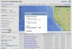
heres the text version of that map, just like the old ALL Quakes list
just practicing for the "every quake, everywhere on the Planet, from every Network" map, certain to stretch Google Maps abilities to the limit.
And I may have underestimated the potential of that realtimeearthquakesmapthingy.
Did you know that if you move the map around to where you want to look then set the Data Feed, that down below that you can download the events as an Excel file.
With an Excel file you can do all sorts of cool stuff.
I don't care for the way USGS presents its maps colour coding by depth, I like to see the magnitudes in colour coding.
Just had a play around with it and got the data for the West Coast USA for 30 days and edited it down to just the 8th and 9th August, 142 events.
Someone complained a few pages back how the 7 days list only went down to magnitude 2.5, I can't find the old ALL quakes list anymore, well using this it goes down to 0.2 magnitude
here is the result, the map is centred on Yorba Linda, California where everyone is getting worked up about, zoom out to see the whole West Coast's events, I see The Geysers is still pumping them micros out as always.
interactive map
screenshot
here is how you get the data as an Excel CSV file

heres the text version of that map, just like the old ALL Quakes list
edit on 9-8-2012 by muzzy because: (no reason given)
just practicing for the "every quake, everywhere on the Planet, from every Network" map, certain to stretch Google Maps abilities to the limit.
edit on 9-8-2012 by muzzy because: (no reason given)
Earthquake - Magnitude 5.2 - SOUTHERN MID-ATLANTIC RIDGE
Not huge, but noteworthy i think.
Earthquake Details This event has been reviewed by a seismologist.
Magnitude 5.2
Date-Time Thursday, August 09, 2012 at 07:09:46 UTC
Thursday, August 09, 2012 at 06:09:46 AM at epicenter
Location 33.128°S, 15.871°W
Depth 10.1 km (6.3 miles)
Region SOUTHERN MID-ATLANTIC RIDGE
Distances
544 km (338 miles) NW of Edinburgh of the Seven Seas, Saint Helena
2786 km (1731 miles) ESE of Sao Joao da Barra, Brazil
2796 km (1737 miles) ESE of Armacao de Buzios, Brazil
2797 km (1737 miles) ESE of Arraial do Cabo, Brazil
Location Uncertainty
horizontal +/- 16.9 km (10.5 miles);
depth +/- 3.8 km (2.4 miles)
Parameters NST= 95, Nph= 96, Dmin=544.4 km, Rmss=0.48 sec, Gp= 58°, M-type=body wave magnitude (Mb), Version=9
Source
Magnitude: USGS NEIC (WDCS-D) Location: USGS NEIC (WDCS-D) Event ID usb000bstp - USGS
Not huge, but noteworthy i think.
reply to post by harryhaller
The Mid-Atlantic Ridge does seem to be busy, along with this one from the Sandwich Islands.
South Alaska (and the whole West Coast for that matter) seem to be pretty busy as well, Mag 4.9 just 28 minutes ago along with the 4.3 off the Northern California coast 116 minutes ago. Just finished reading another thread related to predictions for the weekend which has now been closed by the moderators. I'll leave that one alone, but it has tweaked my curiosity a bit.
The Mid-Atlantic Ridge does seem to be busy, along with this one from the Sandwich Islands.
Earthquake Details
This event has been reviewed by a seismologist.
Magnitude 5.4
Date-Time Thursday, August 09, 2012 at 15:03:07 UTC
Thursday, August 09, 2012 at 01:03:07 PM at epicenter
Time of Earthquake in other Time Zones
Location 59.777°S, 28.180°W
Depth 150.2 km (93.3 miles)
Region SOUTH SANDWICH ISLANDS REGION
Distances 129 km (80 miles) SW (227°) from Bristol Island, South Sandwich Islands
345 km (214 miles) S (189°) from Visokoi Island, South Sandwich Islands
2040 km (1268 miles) SE (128°) from STANLEY, Falkland Islands
2675 km (1662 miles) ESE (123°) from Punta Arenas, Chile
Location Uncertainty horizontal +/- 17.5 km (10.9 miles); depth +/- 9.3 km (5.8 miles)
Parameters NST= 80, Nph= 91, Dmin=>999 km, Rmss=0.92 sec, Gp= 65°,
M-type=body wave magnitude (Mb), Version=7
Source Magnitude: USGS NEIC (WDCS-D)
Location: USGS NEIC (WDCS-D)
Event ID usb000bt48
South Alaska (and the whole West Coast for that matter) seem to be pretty busy as well, Mag 4.9 just 28 minutes ago along with the 4.3 off the Northern California coast 116 minutes ago. Just finished reading another thread related to predictions for the weekend which has now been closed by the moderators. I'll leave that one alone, but it has tweaked my curiosity a bit.
edit on 9-8-2012 by sageturkey because: Southern Alaska
Quake downgraded from 5.2 to 4.9
new topics
-
OK this is sad but very strange stuff
Paranormal Studies: 1 hours ago -
Islam And A Book Of Lies
Religion, Faith, And Theology: 2 hours ago -
Sorry to disappoint you but...
US Political Madness: 5 hours ago -
Watch as a 12 million years old Crab Emerges from a Rock
Ancient & Lost Civilizations: 9 hours ago
top topics
-
Sorry to disappoint you but...
US Political Madness: 5 hours ago, 13 flags -
Just Sick of It! Done! Can't take it anymore!
General Chit Chat: 17 hours ago, 9 flags -
ILLUMINATION: Dimensions / Degrees – Da Vincis Last Supper And The Philosophers Stone
Secret Societies: 16 hours ago, 9 flags -
Watch as a 12 million years old Crab Emerges from a Rock
Ancient & Lost Civilizations: 9 hours ago, 9 flags -
OK this is sad but very strange stuff
Paranormal Studies: 1 hours ago, 4 flags -
Islam And A Book Of Lies
Religion, Faith, And Theology: 2 hours ago, 1 flags
active topics
-
Musk calls on King Charles III to dissolve Parliament over Oldham sex grooming gangs
Mainstream News • 179 • : NoCorruptionAllowed -
What Is 'Quad Demic'? Mask Mandate Returns In These US States
Diseases and Pandemics • 39 • : AdultMaleHumanUK -
Meta Llama local AI system is scary good
Science & Technology • 38 • : glend -
Sorry to disappoint you but...
US Political Madness • 13 • : nugget1 -
OK this is sad but very strange stuff
Paranormal Studies • 2 • : Ravenwatcher -
Winter Storm
Fragile Earth • 33 • : rickymouse -
Stuck Farmer And His Queue Jumping Spawn
Rant • 5 • : rickymouse -
Speaking of Pandemics
General Conspiracies • 4 • : rickymouse -
Trump's idea to make Canada the 51st US state: 'Potential is massive'
Mainstream News • 154 • : WeMustCare -
DONALD J. TRUMP - TIME's Most Extraordinary Person of the Year 2024.
Mainstream News • 62 • : WeMustCare