It looks like you're using an Ad Blocker.
Please white-list or disable AboveTopSecret.com in your ad-blocking tool.
Thank you.
Some features of ATS will be disabled while you continue to use an ad-blocker.

Extraordinary Photos From China's Area 51
page: 2share:
The first thing these pics drive me to assume is missile target practice. the white lines look like tracks left from a laser. The older pic were just
boxed straight lines and the new one is more freehand with a perfect triangle, showing its new capabilities. Maybe a new aircraft development. If u
believe WW3 is really going to happen, take a look at JOHNTITOR.COM.
Originally posted by Armadall
Is it that hard to realize that what we are seeing in these images is nothing more than military training areas?
What we are seeing in these images are bombing ranges, particularly the first image, and other training areas and various military infrastructure.
Lots of countries have these sorts of sites, but certainly not for nefarious reasons.
More than likely that is the case here. Some sort of military or state run infrastructure.
I also agree that it is nothing nefarious, just intriguing.
Originally posted by youdidntseeme
An image described as 'HAARP-like' was also captured by Google Earth:
The coordinates are not provided on the photo but are given in the text: 40 24'17.50"N 93 38'15.75"E
This HAARP-like thing is just an ordinary high voltage transformer/substation. Nothing sinister in that.
Originally posted by Lithops
Originally posted by youdidntseeme
An image described as 'HAARP-like' was also captured by Google Earth:
The coordinates are not provided on the photo but are given in the text: 40 24'17.50"N 93 38'15.75"E
This HAARP-like thing is just an ordinary high voltage transformer/substation. Nothing sinister in that.
Thank you, thats exactly what I thought when I saw it, it looks nothing like HAARP but looks everything like a substation, you can even see the shadow of a pylon entering it.
I like the explanation that it is a new city being built, with a population the size of china, it makes perfect sense to build these cities and plan their expansion, what a fantastic opportunity to build a city ready for thousands of people to move in, having schools, police, shops, transport, fire etc etc. all ready on day one of the move in.
Alternatively it could be Al wei wei's latest art project.
Originally posted by youdidntseeme
reply to post by KristinLynnxo
KristinLynnxo,
Thank you for your contribution here. This is exactly what I had hoped some awesome ATS member would go ahead and do. I havnt really gone through the net yet looking for what to make of any of this but i plan on doing so today. These images just add fuel to my fire.
As to what any of it is, one can only speculate unless we get some official reports handed our way with an explanation, but even then, if this truly is China's 'Area 51' what are the chances of that happeneing?
Hey where do you host your files to post on here? Obviously photobucket can't handle this type of attention lol
www.newscientist.com...
My money's on it being a target practice range for the People's Liberation Army.
Why? One of the other formations gives the game away: looking tantalisingly like Stonehenge from a great height, zooming in reveals three aircraft sitting at it's heart. Clearly, it is some kind of military target for airstrike or gunnery practice. Another 4 x 4 piece grid some 200 metres across has some pieces clearly blown to smithereens, again supporting the target practice theory, and a dummy runway in garish bluish-white is probably not for style-conscious aliens but air-to-ground strafing practice.
However, there is always the chance the Google maps have been hacked and that these "structures" are mere overlays, inserted through digital skulduggery and intended to keep conspiracy theorists happy for weeks. The 21st century version of crop circles, in other words.
Who has given China the hardest time ? What city has a similar pattern layout ( triangles and such ) of their road layout ? Just offering up a
possible . Where would it be that the most damage can be done ( if bombing targets ) against your worst critic , if it is a mock up of a specific city
or just random ?
If someone can do an overlay of both and see if they fit together , then there is your answer . Rule out the most obvious then go outward from there .
If someone can do an overlay of both and see if they fit together , then there is your answer . Rule out the most obvious then go outward from there .
Originally posted by watchdog8110
Who has given China the hardest time ? What city has a similar pattern layout ( triangles and such ) of their road layout ? Just offering up a possible . Where would it be that the most damage can be done ( if bombing targets ) against your worst critic , if it is a mock up of a specific city or just random ?
If someone can do an overlay of both and see if they fit together , then there is your answer . Rule out the most obvious then go outward from there .
If you are right, how many cities must one go through for a structure that is just over a mile wide?
For what its worth, it most likely is a military facilty, cant really be sure if its a bombing target, but to me its probably not, it would have been detroyed a long time ago, but apprently was visible in multiple years on GE.
reply to post by youdidntseeme
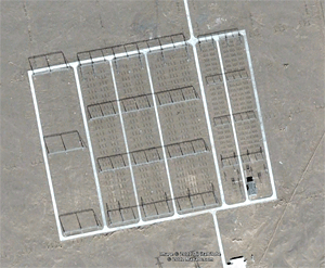
This is the Chinese testing range....
When testing explosives, missiles and guidance systems these are the facilities you would require.
The large white squares with criss-cross patterns are for photo assisted targeting..it's a road map.
The large circular facility is a blast test stand for shock-wave and fragmentation effects.
The large square antenna arrays are for over the horizon radar and also have anti-missile abilities, it is natural that these Chinese would want to harden their missiles against both electronic detection and interference.
As we can see they are also developing bunker busting technologies.
Sadly what we don't see is their stealth technologies, but the antenna arrays would suggest to me that they are working very hard in those areas.
Cosmic..
Originally posted by youdidntseeme
Originally posted by watchdog8110
Who has given China the hardest time ? What city has a similar pattern layout ( triangles and such ) of their road layout ? Just offering up a possible . Where would it be that the most damage can be done ( if bombing targets ) against your worst critic , if it is a mock up of a specific city or just random ?
If someone can do an overlay of both and see if they fit together , then there is your answer . Rule out the most obvious then go outward from there .
If you are right, how many cities must one go through for a structure that is just over a mile wide?
For what its worth, it most likely is a military facilty, cant really be sure if its a bombing target, but to me its probably not, it would have been detroyed a long time ago, but apprently was visible in multiple years on GE.
If they were playing the game of making it so visible as to satellites that are surely over their terrain . A mind game scenario could be put into play to adjust a reaction from the other side . Whether to much is read into the images , perhaps but , possibilities in global mind games between two countries that don't really like each other .
Nothing has been blown up that would confirm it being a target of opportunity based on a similar design of some countries road works , again would persons of the intelligence community not consider the same possibility also . The paranoia factor or one to keep in the just maybe file / mental war fare . The timing of events prior to it's completion could also shed further light as to a validity of it being a target . There is reasoning behind anything done in secluded locations , so until someone from that area turns and speaks as to it's purpose .
Keep your opposition off balance , the more they run around not fully knowing has set the wheels in motion . When microphones are left on and conversations are heard , do you ask was it an accident and or do you ask if it was intentional ? Hmmmm
anybody entertaining the possibility that some of these features have actually been uncovered instead of built by the Chinese?
Originally posted by bottleslingguy
anybody entertaining the possibility that some of these features have actually been uncovered instead of built by the Chinese?
That would only add to the intrigue in my book. Then we would have to figure out who buit then in addition to the why we are already asking.
Good point.
reply to post by youdidntseeme
in the picture of the "unfinished" one with the white lines it looks as though the dirt is being scraped off
in the picture of the "unfinished" one with the white lines it looks as though the dirt is being scraped off
new topics
-
CIA is alleged to be operat social media troll frms in Kyiv
ATS Skunk Works: 39 minutes ago -
Rainbow : Stargazer
Music: 1 hours ago -
I sleep no more.
Philosophy and Metaphysics: 3 hours ago -
Canada caught red-handed manipulating live weather data and make it warmer
Fragile Earth: 3 hours ago -
Why Files Our Alien Overlords | How We Secretly Serve The Tall Whites
Aliens and UFOs: 5 hours ago -
Curse of King Tuts Tomb Solved
Ancient & Lost Civilizations: 6 hours ago -
What allies does Trump have in the world?
ATS Skunk Works: 6 hours ago
top topics
-
Canada caught red-handed manipulating live weather data and make it warmer
Fragile Earth: 3 hours ago, 11 flags -
BIDEN Admin Begins Planning For January 2025 Transition to a New President - Today is 4.26.2024.
2024 Elections: 15 hours ago, 10 flags -
Big Storms
Fragile Earth: 16 hours ago, 9 flags -
Why Files Our Alien Overlords | How We Secretly Serve The Tall Whites
Aliens and UFOs: 5 hours ago, 9 flags -
Curse of King Tuts Tomb Solved
Ancient & Lost Civilizations: 6 hours ago, 7 flags -
What allies does Trump have in the world?
ATS Skunk Works: 6 hours ago, 3 flags -
I sleep no more.
Philosophy and Metaphysics: 3 hours ago, 1 flags -
CIA is alleged to be operat social media troll frms in Kyiv
ATS Skunk Works: 39 minutes ago, 1 flags -
Rainbow : Stargazer
Music: 1 hours ago, 0 flags
active topics
-
Biden tells Netanyahu immediate ceasefire is 'essential'
Mainstream News • 44 • : WeMustCare -
University of Texas Instantly Shuts Down Anti Israel Protests
Education and Media • 345 • : CriticalStinker -
CIA is alleged to be operat social media troll frms in Kyiv
ATS Skunk Works • 4 • : Oldcarpy2 -
Supreme Court Oral Arguments 4.25.2024 - Are PRESIDENTS IMMUNE From Later Being Prosecuted.
Above Politics • 102 • : Sookiechacha -
Canada caught red-handed manipulating live weather data and make it warmer
Fragile Earth • 14 • : YourFaceAgain -
Why Files Our Alien Overlords | How We Secretly Serve The Tall Whites
Aliens and UFOs • 6 • : Dalamax -
Rainbow : Stargazer
Music • 1 • : network dude -
So this is what Hamas considers 'freedom fighting' ...
War On Terrorism • 275 • : YourFaceAgain -
Big Storms
Fragile Earth • 18 • : bluesman023 -
Curse of King Tuts Tomb Solved
Ancient & Lost Civilizations • 5 • : diaclonethunder