It looks like you're using an Ad Blocker.
Please white-list or disable AboveTopSecret.com in your ad-blocking tool.
Thank you.
Some features of ATS will be disabled while you continue to use an ad-blocker.

Earthquake Swarm in Arkansas Intensifies. Memphis, Tennessee could be epicenter for the next big one
page: 126share:
reply to post by tmar11
Satellite image looks kinda volcano crater-like. The Ouachitas DO have some strange formations though
Satellite image looks kinda volcano crater-like. The Ouachitas DO have some strange formations though
Central California had 3.1 then a 3.8 tonight.......
edit on 2-3-2011 by ButterCookie because: (no reason given)
reply to post by ButterCookie
I had just seen that before coming here - hope everyone is alright.
Pretty good shake up with one after the other.
I had just seen that before coming here - hope everyone is alright.
Pretty good shake up with one after the other.
edit on 2-3-2011 by crazydaisy because: (no reason given)
Originally posted by odd1out
reply to post by 9Cib27
You're only allowed to relate this EQ swarm to FRACing on this thread...
Even though historically, there have been three other swarms in this exact area, one of which precedes FRACing in this area by decades! The other two, I'm sure, FRACing was far less in use than it is today in Arkansas. That being said, it can not be ruled out as a possible cause or contributing factor...but BAD SCIENCE prevails.
I'll give you the possibility that the current round of quakes is in no way related to the hydraulic fracturing, even though there are numerous studies that deal with that issue, most if which can be found in the DOE's repository of knowledge by initiating some well phrased searches.
The other issue involved is the fracture fluid itself which I found out about in this post:
Originally posted by jadedANDcynical
Was doing a little more research earlier, before the activity began again and ran across this study, and man am I even more appalled than ever.
Look at where a lot of this water comes from:
Water used for drilling and making up frac fluids can come from several sources: surface water bodies, groundwater, municipal potable water supplies, or reused water from some other water source (most commonly this is flowback water from a previously fractured well)
snip
A large portion of the Marcellus Shale underlies the Susquehanna River basin watershed. Any water usage within the watershed is subject to oversight by the SRBC. Hoffman (2010) notes, that as of January 2010, the SRBC had data for 131 wells. The total volume of water withdrawn through that date is 262 million gallons, with 45% coming from public water supplies and the other 55% coming from surface water sources. The average total volume of fluid used per well is 2.7 million gallons, with 2.2 million gallons of that coming from freshwater sources and 0.5 million gallons coming from recycled flowback water
Emphasis mine
Look at what they tell you they're doing with the used frac'ing fluid:
Not all of the injected frac fluid returns to the surface. GWPC and ALL (2009) report that from 30% to 70% of the original frac fluid volume returns as flowback. However, anecdotal reports from Marcellus operators suggest that the actual percentage is at or below the lower end of that range. The rest of the water remains in pores within the formation. The SRBC data set described in the previous section shows that about 13.5% of the injected frac fluid is recovered (Hoffman 2010).
snip
Operators must manage the flowback and produced water in a cost-effective manner that complies with state regulatory requirements. The primary options are:
Inject underground through a disposal well (onsite or offsite),
Discharge to a nearby surface water body,
Haul to a municipal wastewater treatment plant (often referred to as a publicly owned
treatment works or POTW),
Haul to a commercial industrial wastewater treatment facility, and
Reuse for a future frac job either with or without treatment.
Chapter 3 describes each of these different processes in more detail and identifies those options
that are actually being used by gas operators in the Marcellus Shale region
Again, emphasis mine.
So, you have water being taken out of the normal hydrological cycle never to be returned...
This deals primarily with the processes in the Marcellus Shale Play, but certainly is applicable to the Fayetteville Shale Play.
What sickens me is how open they are with this whole thing. They really need to be brought low...edit on 28-2-2011 by jadedANDcynical because: formatting fix
Keep in mind that these reports portray the best most favorable light possible. If this is what they're willing to tell us, how much do you think might have not made it in to that report? Pretty sure it ain't rose water...
Didn't Robin say Oklahoma was next? A 2.3 showing up in OK. Just checked the USGS site.
Posted Via ATS Mobile: m.abovetopsecret.com

earthquake.usgs.gov...
vancouver island
mt hood also had one today
earthquake.usgs.gov...
also now another cluster starting?
close to home for me, strange day here started out with 6 inches of snow. started plowing at 10 when it stoped, by noon it was 53,
vancouver island
mt hood also had one today
earthquake.usgs.gov...
also now another cluster starting?
close to home for me, strange day here started out with 6 inches of snow. started plowing at 10 when it stoped, by noon it was 53,
edit on
2-3-2011 by Fritzthecat because: (no reason given)
Originally posted by Fritzthecat
earthquake.usgs.gov...
vancouver island
mt hood also had one today
earthquake.usgs.gov...
also now another cluster starting?
close to home for me, strange day here started out with 6 inches of snow. started plowing at 10 when it stoped, by noon it was 53,edit on 2-3-2011 by Fritzthecat because: (no reason given)
wth
reply to post by jadedANDcynical
I agree with you 100%. There's nothing nice to be said about the practice; heck, I'm not even sure we can condone it as a "necessary evil"
Actually, you have helped me to get into more research and your links do expose this particularly e-vile method for "squeezing the last drops of milk from the mother."
I have contacted a friend of friend about this thread; he is head of the geology department at Cal State Fullerton. His credentials and areas of study make him a great expert witness about all of this, unfortunately, his area of geological expertise is quite naturally here in California. Hopefully he gets back to me, but I'm not counting on it.
reply to post by jadedANDcynical
It's pretty easy to figure out. Just Google Earth the long. and lat. of the earthquake epicenter. Any EQ east of the Rocky's and look around on the ground near the epicenter. The drilling rigs, frack ponds and the drill site are all visible within a half mile from the epicenters. The frack ponds are easy to spot because they are square and have a black plastic liner and filled with water.
Just found out today they doing some exploratory drilling and fracking for natural gas in Kokomo Indiana, another location of an earthquake with no fault line.
The Mississinewa Shale shale bed there, I believe. Thought that was interesting information. They are drilling there anyway.....
edit on
2-3-2011 by kimsie because: sorry it is Mississinewa Shale not New Albany.
Originally posted by UtahRosebud
Originally posted by Antoniastar
All the effort and time and passion put into this thread is greatly appreciated.
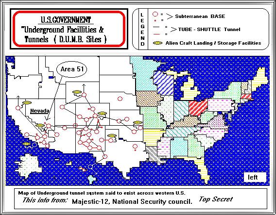
Something I am curious about. Can anyone tell me why, if true, there are no underground bases on the east side of the US? Are there any underground bases on the east side? Does anyone know? I can't imagine why someone would want to build under or around a major fault line or near the NMZ.
I have no idea if this map is an accurate representation of what's really down there but if this map is correct, it sure would fit in with the New Madrid, Guy and other faults.
Iwww.bibliotecapleyades.net...
It could be bunk. : /
Actually there is a huge underground "bunker" of sorts, in Pennsylvania. It's called "Iron Mountain".
Under Iron Mountain
Hi UtahRosebud,
Iron Mountain, I hadn't done any kind of research on it, until you came along. Thank you ever so much for your assistance. Here is a short vid about IM for those who aren't privy (thank you for the link btw )..
Love the vid, has a Star Wars kind of feel to it.
Well here is what I have to say about Iron Mountain. It's very handy in this information-digital age we live in. How very convenient to have such a wonderful "bunker" 2,200 ft. down and so well protected for pictures. So what about people? Where are they gonna go? I mean the ones that can't afford to purchase a private underground city.
Oh well, ha you don't have enough money? Ha ha. Guess you'll have to find a way to survive above ground. Good luck! We'll be prayin' for ya.
What I don't get, what really doesn't fit, is why the hell would a One World Order give a rat's poopy grass about preserving pictures of Einstein and Monroe? There are three reasons...
$ $ $.
Now maybe someone is thinking about the "information management" angle. How fascinating, managing the world's information. That's great? That's dumb, now that just gives the One World Order guys control to do with our history as they please. And not only that, but we give them $$$ to do it. Nice.
And so why not dump it all (cuz c'mon you know they have our emails and vital records info stored elsewhere and, in the "New World" there not going to care if your company suffers without it's documentation) and put a military police or whomever down there in hard times?
Here's some stuff on the NWO for those who want to know more...
en.wikipedia.org...(conspiracy_theory)
I think Iron Mountain is where it is (besides the solid rock roof) because it's close enough in case of a New Madrid/Guy fault event. And possibly throw in a volcanic event, it would not surprise me with all the volcanos making a fuss now-a-days.
I duuno, just thinking out loud. I could be so wrong. Maybe the map of the "Majestic-12" is a farce? Oh that reminds me, here is a definition for that...
Majesty 12 (MJ-12)
Fritz Springmeier mentions MJ-12 or Majesty 12 frequently inside
his book "Be Wise as Serpents". He presents proof that MJ-12 most
certainly existed, maybe even today. When a lot of reseachers
began to touch upon MJ-12, secret service agencies began to put out
a lot of disinformation stories around MJ-12, most all of these
hooking MJ-12 up to some sort of secret UFO team. Well MJ-12 is
very real, but none of its members ever saw or wrote about UFO's
inside official MJ-12 paperwork. To understand the controversy one
needs to know the following :
Majesty is the NAME of a group, which apparently was/is directly
reporting to "Her Majesty" of the BILDERBERGER Group. MAJIC,
MAJORITY, and MAJESTIC are CLASSIFICATIONS used for Documents.
crashrecovery.org...-12
edit on 2-3-2011 by Antoniastar because: I of psi-fare.
edit on 3-3-2011 by Antoniastar because: I don't want to single out
anyone when what I mean by 'you' is 'whomever'.
edit on 3-3-2011 by Antoniastar because: I forgot something.
reply to post by odd1out
I feel as though I owe you an apology, I was overly critical and a bit demeaning as well. It's just that I'm a passionate person when I see something that is obvious to me and tend to assume that it's obviousness is there for all to read. And IF they do happen to set off a larger quake via a butterfly effect or by setting up some sort of resonance which is showing up as microseisms on helicorders in widely separated areas, intentional or accidental, both of which imply rather frightening things in their own right then we all will have hell to deal with, and the frightens me more than a little.
If intentional, then they truly are irredeemably evil.
If accidental, irredeemably clueless.
EGADS!!!
I've been given the constructive criticism(more than once) that I can be a bit harsh in my dealings with others. And it is admittedly something I am working on continually. I consider myself to be open to such coaching and often will try and find a way to apply it once it has been revealed to me. And I feel as though my initial attitude to you fell within this category.
That being said, I am happy to hear that my words provoked a possible line of inquiry that could help to clarify the situation.
Thank you for not responding to my unkind words in kind.
Stay safe, everyone.
Originally posted by mailman05
Originally posted by UtahRosebud
Originally posted by Antoniastar
All the effort and time and passion put into this thread is greatly appreciated.
Something I am curious about. Can anyone tell me why, if true, there are no underground bases on the east side of the US? Are there any underground bases on the east side? Does anyone know? I can't imagine why someone would want to build under or around a major fault line or near the NMZ.
I have no idea if this map is an accurate representation of what's really down there but if this map is correct, it sure would fit in with the New Madrid, Guy and other faults.
Iwww.bibliotecapleyades.net...
It could be bunk. : /
Actually there is a huge underground "bunker" of sorts, in Pennsylvania. It's called "Iron Mountain".
Under Iron Mountain
Ever hear of the "Marengo Warehouse" in marengo Indiana? its part of the Marengo cave system.
It has received over 3.3 million dollars in [link to www.governmentcontractswon.com] contracts over the last 9 years to store FOOD, MRE's to be exact. They have more MRE's stored here than anyplace else on the planet!
edit on 2-3-2011 by mailman05 because: i messed up!
Hi mailman05,
Oh thank you very much for letting me know about this Marengo Warehouse. in Indiana. No, I hadn't heard of it. Oooo it's part of a cave system? How fun. Well ya know, it makes sense that the Military Industrail Complex could be involved, seeing as those are military-grade rations.
Here's a image I found for field rations in case anybody wants to see what they look like (cuz you might not get to in person ). Such a pessimist I am sometimes. Who's hogging all the rations from Indiana anyway???

en.wikipedia.org...:MRE_20071124.PNG
Aren't they something? Wonder if that's alien meat? ha ha just kidding. So very convenient to corner the market on MREs for Indiana. Go Indiana! Jeesh.
I have a theory that I've been kicking around. Wanna hear it?
What if the Fema Region Map is tailored to a catastrophic event in the heart of America? Yes, of course, that's not all it's for, but what if FEMA has taken a mid-U.S catastrophe to mind and have design their 10 regions to reflect geological changes? Hmm?

www.elliscountyobserver.com...
Notice where Indiana is okay? Now the Southern tip is located in the inside, of what I call in my theory, the ' y '. Why? Exactly my point.
That is very very interesting about the location of the rations and they might be used to keep key personnel alive and well to do with an impending disaster (not 'if' but 'when'). Like FEMA personnel and others? Who knows? It's worth a thought at least. I don't think there are any "internment" camps in the ' y ' zone, I'll look again, I definitely am wrong sometimes.
Oh! And there is a vid about FEMA camps that I've seen before (on the author's site) and just saw listed at the bottom of the link I posted above, it's called "Camp FEMA".
blip.tv...
I won't go into the rest of my theory here but I do think that people in the area of the ' y ' need to be extra-thinking about emergency plans for themselves and their families. Who is going to knock on your door and say, "Hey it's time for your preparedness drill"?
And, besides, if nothing happens then what can it hurt to have your own little drill?
Just in case.
edit on 3-3-2011 by Antoniastar because: ooops I didn't credit the MRE pic. Problem fixed.
reply to post by tmar11
Here is an idea. Where the "volcano" was, is near Hot Springs AR. Did perhaps a hot spring temporarily geiser in a different spot due to a temporary build up of pressure?
I am investigating another theory related to something I once read about. It may lead to a total dead end. Enhanced geothermal system (hot rock) drilling was at one time (2009) being projected for upper AR by MT Princeton geothermal. Switzerland had to abandon this since it induced considerable seismic activity. I included a a Youtube link so you can see how enhanced geothermals work. What I am wondering, was if any exploratory sites were drilled in AR. I have been looking like crazy if any one can help.
www.youtube.com...
Enhanced geothermals are used in California at 'The Geysers'.
Wiki The Geysers
And 2 geothermal exploration sites, one in Hawaii and another in Iceland, even hit magma at shallow depths. Those same geologists are even investigating using magma to benefit. Geez...
Now another thought of mine. Geothermal heat pumps are used a lot in AR. Schools, homes, businesses etc... Likely fine, but who is 100% certain of this?
Even if this does not pan out, we have some good data on deep well injection in california... Since AR likely has deep well injection happening in geothermal hot spots also. This is something we need to plot out. So it looks like we may have found our answers. This is likely why the gossip is that the deep well injection sites are likely the culprit.
Here is an idea. Where the "volcano" was, is near Hot Springs AR. Did perhaps a hot spring temporarily geiser in a different spot due to a temporary build up of pressure?
I am investigating another theory related to something I once read about. It may lead to a total dead end. Enhanced geothermal system (hot rock) drilling was at one time (2009) being projected for upper AR by MT Princeton geothermal. Switzerland had to abandon this since it induced considerable seismic activity. I included a a Youtube link so you can see how enhanced geothermals work. What I am wondering, was if any exploratory sites were drilled in AR. I have been looking like crazy if any one can help.
www.youtube.com...
Enhanced geothermals are used in California at 'The Geysers'.
Current studies of The Geysers Geothermal Field seismicity have reached the conclusion that deep-well injection in the field produces mostly microseismic events between magnitude 0.5-3.0 on the Richter Scale (M).[
Wiki The Geysers
And 2 geothermal exploration sites, one in Hawaii and another in Iceland, even hit magma at shallow depths. Those same geologists are even investigating using magma to benefit. Geez...
Now another thought of mine. Geothermal heat pumps are used a lot in AR. Schools, homes, businesses etc... Likely fine, but who is 100% certain of this?
Even if this does not pan out, we have some good data on deep well injection in california... Since AR likely has deep well injection happening in geothermal hot spots also. This is something we need to plot out. So it looks like we may have found our answers. This is likely why the gossip is that the deep well injection sites are likely the culprit.
More digging around here reveals more little tidbits:
Research Org Lawrence Livermore National Laboratory, University of California, Livermore, CA
Sponsoring Org USDOE
From abstract here
Emphasis mine
I love the disclaimer at the end. They're telling us that they REALLY don't know what the effects are, but the only way to find out is to go ahead and do it. ORLY?
Really.
the .pdf here
Has some fascinating info. Its doesn't allow for copy pasting except as images, but in regards to induced seismicity, they're saying that there's no way to know how much they've changed things because they don't have an accurate picture of what it looked like before they started mucking about with stuff.
It's 15 MB, so it's a sizable file. the link is to the page containing it, not the actual .pdf
lemme see, can I find any more...
"Not expected" does not exactly sound like a 100% guarantee
HEY, HERE'S YOUR MICROSEISMS!!!
More still:
All from the .pdf on this page
Research Org Idaho National Laboratory (INL)
Sponsoring Org USDOE
Emphasis mine
Again this statement doesn't fill me with the greatest of confidence.
I'm gonna have to go with CLUELESS.
Finally, we examined the nonpollutant effects of land subsidence and induced seismicity. Land subsidence is possible around some facilities, but surface-related damage is not expected to be great. Induced seismic events that have occurred to date at geothermal resource areas have been nondestructive[. It is not possible to predict accurately the risk of potentially destructive events, and more research is needed in this area.
Research Org Lawrence Livermore National Laboratory, University of California, Livermore, CA
Sponsoring Org USDOE
From abstract here
Emphasis mine
I love the disclaimer at the end. They're telling us that they REALLY don't know what the effects are, but the only way to find out is to go ahead and do it. ORLY?
Really.
the .pdf here
Has some fascinating info. Its doesn't allow for copy pasting except as images, but in regards to induced seismicity, they're saying that there's no way to know how much they've changed things because they don't have an accurate picture of what it looked like before they started mucking about with stuff.
It's 15 MB, so it's a sizable file. the link is to the page containing it, not the actual .pdf
lemme see, can I find any more...
Because the reservoir is kept under pressure continuously, and the amount of fluid in the formation is maintained essentially constant during the operation of the plant, the usual mechanism causing subsidence in hydrothermal systems is absent and, therefore, subsidence impacts are not expected for EGS systems
"Not expected" does not exactly sound like a 100% guarantee
HEY, HERE'S YOUR MICROSEISMS!!!
The process of opening fractures can occur in a sliding manner by shear failure or in extensional manner by tensile failure. In either case, acoustic noise is generated during this process. This acoustic noise is referred to as microseismic noise or events. The acoustic noise is monitored during the stimulation process as an EGS reservoir management tool to see how far the stimulation has opened the reservoir in three dimensions (Batchelor et al., 1983; Baria et al., 1985; Baria and Green, 1989; Baria et al., 1995; Baria, 1990; Baria et al., 2005; Baria et al., 2006). This is analogous to tracking a submarine through acoustic noise patterns. The microseismic monitoring pinpoints how the pressure waves are migrating in the rock mass during the reservoir creation process. In the EGS systems studied to date (see Chapter 4) shear failure has been the dominant mechanism
More still:
The collection of baseline data at the selected site prior to the onset of drilling is useful in separating natural from induced events. Additionally, it is prudent to instrument the site for any unexpected natural or induced felt microseismic events. A procedure also needs to be in effect to assess any effects on the public and local infrastructure. Lastly, sound geological and tectonic investigations must be carried out prior to the selection of the site to avoid the inadvertent lubrication of a major fault that could cause a significant seismic event
All from the .pdf on this page
Research Org Idaho National Laboratory (INL)
Sponsoring Org USDOE
Emphasis mine
Again this statement doesn't fill me with the greatest of confidence.
I'm gonna have to go with CLUELESS.
reply to post by elouina
Well, that was easy. Just needed to put a little time into it. But I think we may have our answer. I just needed to type out all my info and examine it. To sum up my last point I made.... Deep well injection in geothermal areas such as CA cause microsisms and EQ. And if that company does try to do enhanced geothermals in AR, they need blocked big time! Like I said our next step is to find injection wells in geoothermal areas.
Well, that was easy. Just needed to put a little time into it. But I think we may have our answer. I just needed to type out all my info and examine it. To sum up my last point I made.... Deep well injection in geothermal areas such as CA cause microsisms and EQ. And if that company does try to do enhanced geothermals in AR, they need blocked big time! Like I said our next step is to find injection wells in geoothermal areas.
edit on 3-3-2011 by elouina because: (no reason given)
edit on 3-3-2011 by elouina because: (no reason given)
reply to post by elouina
the first google result in my search...
"2 Ark. injection wells may be closed amid quakes"
Edited... I just noticed that this was posted earlier. Well, this is a good time for me to mention the swarm in yellowstone. And the injection in its geothermal areas also. Along with all the swarms in CA that folks are living with. Is this how government does business? Money comes first? They knew all along....
edit on 3-3-2011 by elouina because: Injection wells cosing was Posted already...
edit on 3-3-2011 by
elouina because: (no reason given)
reply to post by jadedANDcynical
I completely understand, I'm the same way, we are all the same way! No apology necessary.
I didn't react so much, because as I said I haven't discounted the theories here at all. I wish I had the time, and the passion yourself and so many others here have about what's going on to dig in a little further. I have some theories of my own, but until I can back them up, I'll keep them to myself. If it was closer to home, sorry to say, I'd be on it 24/7...but I'm in southern coastal California...I have my own backyard to worry about
On the other hand, there has been quite a bit of evidence to back up the idea the FRACing is at least partly responsible for what's happening and it seems, based on what I've been reading, it could only be exacerbating any naturally occurring activity in this area---PERIOD. Suffice it to say, after some lengthy reads my position has become a bit more flexible; that combined with a bit more research on the geological make-up of the area. I still hold the position that there is more here than meets the eye, and further, I agree with some geologists that say nothing devastating will happen in the area of this particular swarm. I'm looking up the road a little...consider that my prediction.
Unfortunately for myself, the information I need to further my ideas seems to pre-date any reliable sources and written records, at least those I have access to at this time. In addition, it appears that in this information age there aren't very many reliable sources about much of anything; that goes back to my "rebuttal" earlier in the thread. We really can't even trust what comes out of our universities, research labs, public offices, government and the list goes on and on and on. Everyone has a freaking agenda and it's really hard to find something 100% impartial. The WWWeb really is a web, and there may be little in the way of metaphor when I say that...
But try to find some old books...geez, you have to outbid people on eBay...and some of them have an agenda too!
reply to post by elouina
Has ANYONE ever entertained the idea, just for a second, that FRACing in hydrothermal areas/ seismically active areas, may be by design? How many geologists work for these companies anyway, and where do they come from...? Who do they ultimately answer and report to?
Just asking....
Has ANYONE ever entertained the idea, just for a second, that FRACing in hydrothermal areas/ seismically active areas, may be by design? How many geologists work for these companies anyway, and where do they come from...? Who do they ultimately answer and report to?
Just asking....
edit on 3-3-2011 by odd1out because: (no reason given)
Originally posted by odd1out
reply to post by elouina
Has ANYONE ever entertained the idea, just for a second, that FRACing in hydrothermal areas/ seismically active areas, may be by design? How many geologists work for these companies anyway, and where do they come from...? Who do they ultimately answer and report to?
Just asking....edit on 3-3-2011 by odd1out because: (no reason given)
Your comment brings this to mind.... I bet these areas are not in any of the "involved parties" back yards...
new topics
-
Gen Flynn's Sister and her cohort blow the whistle on DHS/CBP involvement in child trafficking.
Whistle Blowers and Leaked Documents: 4 hours ago -
Anybody else using Pomodoro time management technique?
General Chit Chat: 6 hours ago -
Bucks County commissioners vote to count illegal ballots in Pennsylvania recount
2024 Elections: 9 hours ago -
Trump sues media outlets -- 10 Billion Dollar lawsuit
US Political Madness: 10 hours ago -
Fired fema employee speaks.
US Political Madness: 10 hours ago -
How long till it starts
US Political Madness: 11 hours ago
top topics
-
Trump sues media outlets -- 10 Billion Dollar lawsuit
US Political Madness: 10 hours ago, 23 flags -
Bucks County commissioners vote to count illegal ballots in Pennsylvania recount
2024 Elections: 9 hours ago, 20 flags -
How long till it starts
US Political Madness: 11 hours ago, 17 flags -
USSS Agent Fired for Having Sex In Michelle Obama's Bathroom
Politicians & People: 13 hours ago, 10 flags -
Watching TV
Jokes, Puns, & Pranks: 16 hours ago, 9 flags -
Fired fema employee speaks.
US Political Madness: 10 hours ago, 9 flags -
Gen Flynn's Sister and her cohort blow the whistle on DHS/CBP involvement in child trafficking.
Whistle Blowers and Leaked Documents: 4 hours ago, 6 flags -
Anybody else using Pomodoro time management technique?
General Chit Chat: 6 hours ago, 3 flags
active topics
-
USSS Agent Fired for Having Sex In Michelle Obama's Bathroom
Politicians & People • 24 • : rickymouse -
The Acronym Game .. Pt.4
General Chit Chat • 962 • : FullHeathen -
How long till it starts
US Political Madness • 16 • : rickymouse -
TRUMP Could Be Our Modern Day MOSES - The Similarities are Striking.
ATS Skunk Works • 246 • : WeMustCare -
Bucks County commissioners vote to count illegal ballots in Pennsylvania recount
2024 Elections • 18 • : rickymouse -
Anybody else using Pomodoro time management technique?
General Chit Chat • 7 • : tamusan -
The Trump effect 6 days after 2024 election
2024 Elections • 141 • : cherokeetroy -
Thanksgiving 2024
Member Art • 19 • : rickymouse -
President-Elect Donald Trump will Meet with Coup-Victim JOE BIDEN on Wed 11.13.2024.
2024 Elections • 35 • : WeMustCare -
Mike Tyson returns 11-15-24
World Sports • 46 • : argentus