It looks like you're using an Ad Blocker.
Please white-list or disable AboveTopSecret.com in your ad-blocking tool.
Thank you.
Some features of ATS will be disabled while you continue to use an ad-blocker.

Odd-looking Military Aircraft in the Alaskan Wilderness
page: 1share:
Hi all!
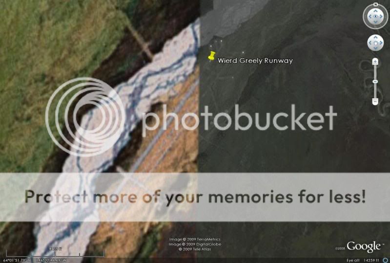
Just to kick things off, I've spent alot of time reading and looking into this very bizarre landing strip I found in google earth. After looking around in google earth I discovered this really odd looking (and pretty danged long) landing strip in the middle of nowhere. Landing strip is approximately 1.7 miles (around 2 miles) in length.
The coordinates for this location are:
64° 2'16.93"N
146°22'28.72"W
Because of the details of my job, I am not at liberty to discuss the particulars of my work and although not all of it is classified I do work in an area of the private sector where information is highly confidential. But keep in mind that everything I will post here is publicly available on the internet and is unclassified material (just to get things straight right off the bat). Alot of it is difficult to find, however.
Just for some personal background, I spent 6 years in the USAF working in the 2w0x1 career field in munitions systems (non-nuclear). The work I did was really wide-ranging. Everything from hauling munitions trailers to and from the flightline to building conventional bombs and processing 30mm ammunition for the A-10's. Because of my work in the military, I saw about every aircraft in the inventory either coming or going at some point, everything from A-10's to B-2's and U-2 spy planes.
The runway in question at the above coordinates has a variety of aspects that point to this being a classified operating location. The area is completely remote and is about 20 miles from Fort Greely (army post) which lies to the SE from the location of the runway. West of Fort Greely (across the Richardson Highway) lies what we call the "Donnelly Training Area" named after the nearby "Donnelly Dome" which is a very distinct land feature in this area. Donnelly Training Area is a pretty immense tract of land. Some of it is public land because of the Pipeline running through it and the pumping stations along the pipeline. But most of it is government-owned land used for a wide variety of training purposes.
Fort Greely is home to the new Missile Defense site and CRTC (Cold Regions Test Center). The area of the remote runway does not lie in the inclusive area of the Donnelly Training Area, rather, it seems it is a completely separate operating location from Greely or Donnelly Training area.
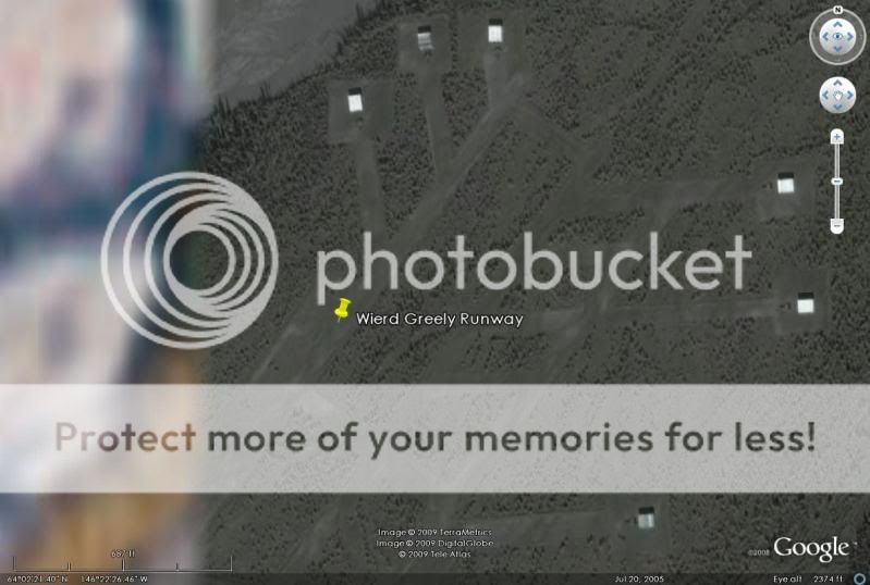
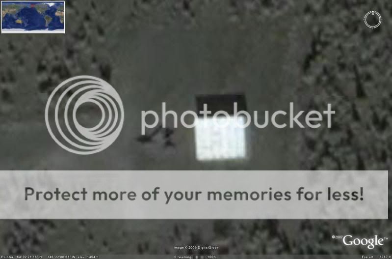
The odd thing is, there are no support facilities.. There is a 1.7 mile pair of runways and taxiways on the Northeast end of the runway. The runway isn't even gravel or dirt. It appears to be akin to freshly-mowed grass. The white squares you see behind some of the aircraft originally looked to me like some kind of temporary structures for housing the aircraft. After looking at the image a little closer, I believe these are for deflection of aircraft thrust up and away from the treeline. There appears to be a built-in system designed for quick-reaction takeoffs. Also notice the complex system of strips, taxiways, and aircraft parking (all apparently built around the idea of launching aircraft at a moment's notice). For Reconnaissance??
Here is a list of the Alaskan military facilities and their distance from this remote airstrip:
Eielson AFB...........50 miles away
Clear AFB.............85 miles away
Elmendorf AFB......223 miles away
Fort Wainwright.....66 miles away
Fort Greely ..........20 miles away
Fort Richardson.....220 miles away
The nearest site is, of coarse, Fort Greely which is an army base anyway (no fighters to speak of). The Donnelly Training Area West/SW from Fort Greely is used for Army training purposes. Yet there is a remote airstrip with odd looking fighter jets 20 miles from civilization in the middle of the boonies with no support facilities to speak of and a grass airstrip. Could there be facilities underground to hide them from satellites? This is not your standard military airstrip. This looks to have been built and constructed for a very specific purpose. Also notice that some of the planes are missing (possibly even flying sorties at the time the google earth images were shot?).
There is a reason this facility was built and there is also a reason they are using this particular airstrip for these jets instead of the various other facilities throughout the state.
Here are some images..
Entire airstrip:
Area showing taxiways, aircraft, and what may be deflectors behind some of the aircraft:
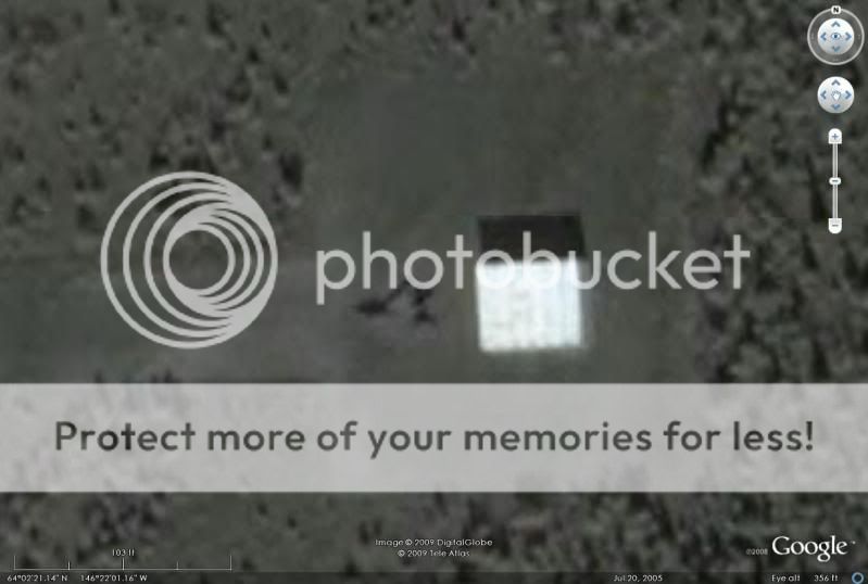
One of the parked aircraft showing the deflector:
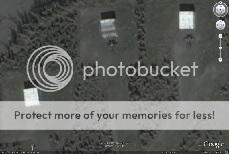
3 more of the same kind of jet with deflectors behind them (notice the metallic sheen of the deflector in the middle. This and the shadows tell me that's what these are:
taxiway and aircraft parking locations not being used:

Closeups of some of the parked jets:


I know it is unlikely, but could this aurora?
In order to get an accurate assessment of the actual dimensions of these jets, I measured the wingspan of one of the jets in google earth. I then exported the image to Autocad and scaled 2 of the aircraft closeups to full-scale. I then added dimensions in Autocad to show the measurements.
Here's what we're dealing with..


Keep in mind this is an estimated size of this particular kind of aircraft. This is not 100% accurate but probably in the ballpark.
Wingspan....................................................... 28 feet
Length of aircraft............................................ 31 feet
Length of aircraft (including vert. stabilizers)..... 37 feet
Width of vertical stabilizers (tip to tip)............... 12 feet
This appears to be a delta-wing type configuration with 2 powerplants.
They have two vertical stabilizers at the rear that are slightly angled/canted (not perfectly vertical). You can see this in some of the aircraft closeups. The delta-wing leading edge is pretty danged long (around 18 feet in length from the tip of the wing to where it joins up with the fuselage near the cockpit).
Any thoughts or opinions on what this could be?
Right off the bat, I'd like to thank Zorgon's for his assistance with this and for posting content up on his website regarding this bizarre landing strip in the middle of the Alaskan wilderness.
-ChriS
Just to kick things off, I've spent alot of time reading and looking into this very bizarre landing strip I found in google earth. After looking around in google earth I discovered this really odd looking (and pretty danged long) landing strip in the middle of nowhere. Landing strip is approximately 1.7 miles (around 2 miles) in length.
The coordinates for this location are:
64° 2'16.93"N
146°22'28.72"W
Because of the details of my job, I am not at liberty to discuss the particulars of my work and although not all of it is classified I do work in an area of the private sector where information is highly confidential. But keep in mind that everything I will post here is publicly available on the internet and is unclassified material (just to get things straight right off the bat). Alot of it is difficult to find, however.
Just for some personal background, I spent 6 years in the USAF working in the 2w0x1 career field in munitions systems (non-nuclear). The work I did was really wide-ranging. Everything from hauling munitions trailers to and from the flightline to building conventional bombs and processing 30mm ammunition for the A-10's. Because of my work in the military, I saw about every aircraft in the inventory either coming or going at some point, everything from A-10's to B-2's and U-2 spy planes.
The runway in question at the above coordinates has a variety of aspects that point to this being a classified operating location. The area is completely remote and is about 20 miles from Fort Greely (army post) which lies to the SE from the location of the runway. West of Fort Greely (across the Richardson Highway) lies what we call the "Donnelly Training Area" named after the nearby "Donnelly Dome" which is a very distinct land feature in this area. Donnelly Training Area is a pretty immense tract of land. Some of it is public land because of the Pipeline running through it and the pumping stations along the pipeline. But most of it is government-owned land used for a wide variety of training purposes.
Fort Greely is home to the new Missile Defense site and CRTC (Cold Regions Test Center). The area of the remote runway does not lie in the inclusive area of the Donnelly Training Area, rather, it seems it is a completely separate operating location from Greely or Donnelly Training area.
The odd thing is, there are no support facilities.. There is a 1.7 mile pair of runways and taxiways on the Northeast end of the runway. The runway isn't even gravel or dirt. It appears to be akin to freshly-mowed grass. The white squares you see behind some of the aircraft originally looked to me like some kind of temporary structures for housing the aircraft. After looking at the image a little closer, I believe these are for deflection of aircraft thrust up and away from the treeline. There appears to be a built-in system designed for quick-reaction takeoffs. Also notice the complex system of strips, taxiways, and aircraft parking (all apparently built around the idea of launching aircraft at a moment's notice). For Reconnaissance??
Here is a list of the Alaskan military facilities and their distance from this remote airstrip:
Eielson AFB...........50 miles away
Clear AFB.............85 miles away
Elmendorf AFB......223 miles away
Fort Wainwright.....66 miles away
Fort Greely ..........20 miles away
Fort Richardson.....220 miles away
The nearest site is, of coarse, Fort Greely which is an army base anyway (no fighters to speak of). The Donnelly Training Area West/SW from Fort Greely is used for Army training purposes. Yet there is a remote airstrip with odd looking fighter jets 20 miles from civilization in the middle of the boonies with no support facilities to speak of and a grass airstrip. Could there be facilities underground to hide them from satellites? This is not your standard military airstrip. This looks to have been built and constructed for a very specific purpose. Also notice that some of the planes are missing (possibly even flying sorties at the time the google earth images were shot?).
There is a reason this facility was built and there is also a reason they are using this particular airstrip for these jets instead of the various other facilities throughout the state.
Here are some images..
Entire airstrip:
Area showing taxiways, aircraft, and what may be deflectors behind some of the aircraft:
One of the parked aircraft showing the deflector:
3 more of the same kind of jet with deflectors behind them (notice the metallic sheen of the deflector in the middle. This and the shadows tell me that's what these are:
taxiway and aircraft parking locations not being used:
Closeups of some of the parked jets:
I know it is unlikely, but could this aurora?
In order to get an accurate assessment of the actual dimensions of these jets, I measured the wingspan of one of the jets in google earth. I then exported the image to Autocad and scaled 2 of the aircraft closeups to full-scale. I then added dimensions in Autocad to show the measurements.
Here's what we're dealing with..
Keep in mind this is an estimated size of this particular kind of aircraft. This is not 100% accurate but probably in the ballpark.
Wingspan....................................................... 28 feet
Length of aircraft............................................ 31 feet
Length of aircraft (including vert. stabilizers)..... 37 feet
Width of vertical stabilizers (tip to tip)............... 12 feet
This appears to be a delta-wing type configuration with 2 powerplants.
They have two vertical stabilizers at the rear that are slightly angled/canted (not perfectly vertical). You can see this in some of the aircraft closeups. The delta-wing leading edge is pretty danged long (around 18 feet in length from the tip of the wing to where it joins up with the fuselage near the cockpit).
Any thoughts or opinions on what this could be?
Right off the bat, I'd like to thank Zorgon's for his assistance with this and for posting content up on his website regarding this bizarre landing strip in the middle of the Alaskan wilderness.
-ChriS
Awesome find man, going to check it out now on Google. Maybe this is where they house the F 302's before sending them to Atlantis
Nice job
Now you get to do the other area
Here is a plane close up... still working on getting better details

Page is here as we get mor information on this
What gets me is that Google caught them all on the ground. Usually the 'good stuff' is in hangers when google is over head
www.thelivingmoon.com...
Now you get to do the other area
Here is a plane close up... still working on getting better details
Page is here as we get mor information on this
What gets me is that Google caught them all on the ground. Usually the 'good stuff' is in hangers when google is over head
www.thelivingmoon.com...
could be this F-35_Lightning_II
[atsimg]http://files.abovetopsecret.com/images/member/cef57eb7a02f.jpg[/atsimg]
[edit on 25-8-2009 by ashnomadonte]
[atsimg]http://files.abovetopsecret.com/images/member/cef57eb7a02f.jpg[/atsimg]
The Lockheed Martin F-35 Lightning II is a fifth-generation, single-seat, single-engine, stealth-capable military strike fighter, a multirole aircraft that can perform close air support, tactical bombing, and air defense missions.[6] The F-35 has three different models; one is the conventional takeoff and landing variant, the second is short takeoff and vertical-landing variant, and the third is a carrier-based variant.
The F-35 is descended from the X-35, the product of the Joint Strike Fighter (JSF) program. Its development is being principally funded by the United States, with the United Kingdom and other partner governments providing additional funding.[7] It is being designed and built by an aerospace industry team led by Lockheed Martin with Northrop Grumman and BAE Systems as major partners.[7] Demonstrator aircraft flew in 2000,[8] with the first flight on 15 December 2006
[edit on 25-8-2009 by ashnomadonte]
If it was so secret I hardly doubt you'd be able to pull it up on google earth or whatever. Interesting but probably nothing we aren't meant to
see.
Originally posted by Zosynspiracy
If it was so secret I hardly doubt you'd be able to pull it up on google earth or whatever. Interesting but probably nothing we aren't meant to see.
What... jealous cuz YOU didn't find a cool find?
Here in Nevada we have a Red Flag site north of Nellis AFB and LAS Vegas. Maybe this is the Red Flag area of Eielson AFB
RED FLAG - ALASKA
Eielson Air Force Base and Elmendorf Air Force Base are the home of RED FLAG-Alaska, a realistic, 10-day air combat training exercise held up to four times a year. Each RED FLAG-Alaska exercise is a multi-service, multi-platform coordinated, combat operations exercise and corresponds to the designed operational capability of participating units. In other words, exercises often involve several units whose military mission may differ significantly from that of other participating units. RED FLAG-Alaska planners take those factors into consideration when designing exercises so participants get the maximum training possible without being placed at an unfair advantage during simulated combat scenarios.
www.eielson.af.mil...
All RED FLAG-Alaska exercises take place over Alaskan and Western Canadian airspace. The entire airspace is made up of 17 permanent military operations areas and high altitude training areas, plus two restricted areas, for a total airspace of more than 67,000 square miles.
What struck me most was the lack of facilities on the site save for the hangers. Very similar to Nellis' area
RED FLAG-Alaska is a Pacific Air Forces-sponsored exercise. Originally named COPE THUNDER, it was moved to Eielson Air Force Base, Alaska, from Clark Air Base, Philippines, in 1992 after the eruption of Mount Pinatubo on June 15, 1991 forced the curtailment of operations. COPE THUNDER was redesignated RED FLAG-Alaska in 2006.
When the decision was made to relocate COPE THUNDER, Air Force officials viewed Eielson as the most logical choice. That decision was based partly on the fact that Eielson's 353rd Combat Training Squadron already controlled and maintained three major military flight training ranges in Alaska.
en.wikipedia.org...
[edit on 25-8-2009 by zorgon]
Sorry to curb your enthusiasm. Those are F-15s from Elmendorf AFB. Same as the ones at Tyndall AFB, for example. Nice post and interesting place for
sure though.
30°4′43″N 85°34′35″W
30°4′43″N 85°34′35″W
Doesn't matter what aircraft they are , its still a cool 'close-up' and makes me wonder what kind of 'close-up' functions the military have in
their satelites?
Looks like a target range for Red Flag Alaska exercises. F-15s obviously can not operate from a tundra airstrip that has no infrastructure, nor do
you see evidence on the surface of any aircraft movement.
You're actually NOT seeing the entire runway complex.
What is being displayed is the northern section of the runway that was constructed AFTER July 19, 2005. The southern section of the runway is NOT being shown as that section of the Google map display is prior to construction i.e. PRE July 19, 2005.
This means that there may also be supporting buildings/complexes around the southern part of the runway which would not be visible if constructed AFTER July 19, 2005.
Also, there is some kind of storage area located approx 6kms east of the runway at location
64° 1' 19.54"N
146° 15' 18.41"W
which has a direct road connection to the runway.
Plus many other associated structures /objects scattered around at location
64° 1' 5.15"N
146° 18' 53.63"W
F-35 or F-15's eh?
F-35 A/C - Wingspan 35 feet. F-35 C - 43 feet; Length 51.3 to 51.5 feet.
F-15 - Wingspan 42 feet 10 inches; Length - 63 feet 9 inches
F-22 - Wingspan 44 feet 6 inches; Length - 62 feet 1 inch
[atsimg]http://files.abovetopsecret.com/images/member/8190bca3542c.png[/atsimg]
Bit on the small side don't you think?
Granted, there may be some slop in Google Earth's measurements.
Mig-25 Foxbat:
Length: 19.75 m (64 ft 10 in)
Wingspan: 14.01 m (45 ft 11.5 in)
Length: 19.75 m (64 ft 10 in)
Wingspan: 14.01 m (45 ft 11.5 in)
reply to post by BlasteR
Sir,
This is all a good theory. But I am an Air Force photographer stationed at Elmendorf Air Force Base. I flew to the above-mentioned location in a C-12 yesterday to take pictures of the C-17's stationed here doing dirt-landings and assisting in an Army Pre-Deployment Training Exercise. All the airstrip is used for is practicing dirt landings. Nothing special about it really. The remote location is only to keep the complaints down from locals on the noise, dust disturbance etc. that this causes with each landing. Also it is close to a sister Army base and gives us a good location in assisting with their many exercises in which they are not equipped to practice air-exercise. Please let me know if you have any other questions on this particular landing strip. Thanks!
SrA Laura ------
Originally posted by BlasteR
Wingspan....................................................... 28 feet
Length of aircraft............................................ 31 feet
That gives a Length to Wing Ratio of 1.11.
Sorry, but those photos do not look like Tomcats. It just doesn't wash. And that is the one with the closest ratio. Not to mention that the thing is much smaller than any of these... the shortest one, the F-16 Fighting Falcon, is 49 ft 5 in long.
Length to Wing ratios of some common fighters:
F-14 Tomcat spread - 0.98
F-35 Lightening C - 1.20
MiG-27 Flogger spread 1.24
F-22 Raptor - 1.28
Mig-25 Foxbat - 1.32
F/A-18 Super Hornet E/F - 1.34
F/A-18 Hornet C/D - 1.40
F-35 Lightening B - 1.47
F-35 Lightning A - 1.47
F-15 Strike Eagle - 1.49
F-16 Fighting Falcon - 1.51
Mig-29 Fulcrum - 1.53
F-14 Tomcat swept - 1.65
MiG-27 Flogger swept - 2.31
[edit on 25-8-2009 by RoofMonkey]
Originally posted by DataWraith
Doesn't matter what aircraft they are , its still a cool 'close-up' and makes me wonder what kind of 'close-up' functions the military have in their satelites?
Common misconception my friend!
Google Earth only uses satellite imagery so far... Once you zoom in past a certain point it slips into ariel photography from high flying planes... Sometimes you can see that the pictures were taken at different times of the day and hughe shadows eith appear or disappear... Or if your view is blocked by cloud cover it's sometimes worth zooming in any way, sometimes the clouds disappear at the switch over.
I have no idea about military grade sats - but I have heard that they don't get any finer than a 1 meter resoloution... Don't know if that's true or not.
Originally posted by Now_Then
... I have no idea about military grade sats - but I have heard that they don't get any finer than a 1 meter resoloution... Don't know if that's true or not.
If you take the resolution of the Hubble, and apply it to the distance of known spy satellite orbits, you get resolutions on the order of about 4 to 6 inches.
And that's late 80's technology.
[edit on 25-8-2009 by RoofMonkey]
Originally posted by Voiceoftreason
Sorry to curb your enthusiasm. Those are F-15s from Elmendorf AFB. Same as the ones at Tyndall AFB, for example. Nice post and interesting place for sure though.
30°4′43″N 85°34′35″W
...LOL, this is great, I was born at the Air Force Hospital on Ft Elmendorf in 1957. Times have changed since them.
An F-15 at Tyndall... with the same scaling marks I put on the other picture.
[atsimg]http://files.abovetopsecret.com/images/member/57d1e6e1a401.png[/atsimg]
CAVEAT: Topological projection errors can cause the mismatch in the photos. But at first sniff... they don't compare in size.
[atsimg]http://files.abovetopsecret.com/images/member/57d1e6e1a401.png[/atsimg]
CAVEAT: Topological projection errors can cause the mismatch in the photos. But at first sniff... they don't compare in size.
new topics
-
President BIDEN's FBI Raided Donald Trump's Florida Home for OBAMA-NORTH KOREA Documents.
Political Conspiracies: 3 hours ago -
Maestro Benedetto
Literature: 5 hours ago -
Is AI Better Than the Hollywood Elite?
Movies: 5 hours ago -
Las Vegas UFO Spotting Teen Traumatized by Demon Creature in Backyard
Aliens and UFOs: 9 hours ago -
2024 Pigeon Forge Rod Run - On the Strip (Video made for you)
Automotive Discussion: 9 hours ago -
Gaza Terrorists Attack US Humanitarian Pier During Construction
Middle East Issues: 10 hours ago -
The functionality of boldening and italics is clunky and no post char limit warning?
ATS Freshman's Forum: 11 hours ago -
Meadows, Giuliani Among 11 Indicted in Arizona in Latest 2020 Election Subversion Case
Mainstream News: 11 hours ago
top topics
-
President BIDEN's FBI Raided Donald Trump's Florida Home for OBAMA-NORTH KOREA Documents.
Political Conspiracies: 3 hours ago, 25 flags -
Krystalnacht on today's most elite Universities?
Social Issues and Civil Unrest: 15 hours ago, 9 flags -
University of Texas Instantly Shuts Down Anti Israel Protests
Education and Media: 17 hours ago, 8 flags -
Weinstein's conviction overturned
Mainstream News: 13 hours ago, 8 flags -
Supreme Court Oral Arguments 4.25.2024 - Are PRESIDENTS IMMUNE From Later Being Prosecuted.
Above Politics: 15 hours ago, 8 flags -
Massachusetts Drag Queen Leads Young Kids in Free Palestine Chant
Social Issues and Civil Unrest: 12 hours ago, 7 flags -
Gaza Terrorists Attack US Humanitarian Pier During Construction
Middle East Issues: 10 hours ago, 7 flags -
Las Vegas UFO Spotting Teen Traumatized by Demon Creature in Backyard
Aliens and UFOs: 9 hours ago, 6 flags -
Meadows, Giuliani Among 11 Indicted in Arizona in Latest 2020 Election Subversion Case
Mainstream News: 11 hours ago, 5 flags -
2024 Pigeon Forge Rod Run - On the Strip (Video made for you)
Automotive Discussion: 9 hours ago, 4 flags
active topics
-
Truth Social goes public, be careful not to lose your money
Mainstream News • 130 • : Astyanax -
Las Vegas UFO Spotting Teen Traumatized by Demon Creature in Backyard
Aliens and UFOs • 11 • : AwakeNotWoke -
President BIDEN's FBI Raided Donald Trump's Florida Home for OBAMA-NORTH KOREA Documents.
Political Conspiracies • 15 • : AwakeNotWoke -
Is AI Better Than the Hollywood Elite?
Movies • 13 • : Justoneman -
Hate makes for strange bedfellows
US Political Madness • 47 • : 19Bones79 -
-@TH3WH17ERABB17- -Q- ---TIME TO SHOW THE WORLD--- -Part- --44--
Dissecting Disinformation • 689 • : daskakik -
University of Texas Instantly Shuts Down Anti Israel Protests
Education and Media • 265 • : Astrocometus -
Gaza Terrorists Attack US Humanitarian Pier During Construction
Middle East Issues • 27 • : ToneD -
Reason of the Existence
The Gray Area • 21 • : BingoMcGoof -
Supreme Court Oral Arguments 4.25.2024 - Are PRESIDENTS IMMUNE From Later Being Prosecuted.
Above Politics • 85 • : Sookiechacha