It looks like you're using an Ad Blocker.
Please white-list or disable AboveTopSecret.com in your ad-blocking tool.
Thank you.
Some features of ATS will be disabled while you continue to use an ad-blocker.

Virginia POW Camp That Doesn't Exist
page: 12
share:
[whatreallyhappened.com...]
Virginia POW Camp That Doesn't Exist - Ted Twietmeyer & his associates start with a line of overview images of that POW camp along with the training facilities near it. They plan to share more images (from a closer viewpoint) so you can look at these in more detail, later.
More figures with details at: www.data4science.net...
[edit on 7-4-2009 by News And History]
Virginia POW Camp That Doesn't Exist - Ted Twietmeyer & his associates start with a line of overview images of that POW camp along with the training facilities near it. They plan to share more images (from a closer viewpoint) so you can look at these in more detail, later.
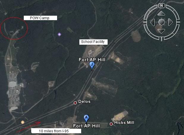
We will start with overview images of the POW camp and training facilities, and look at these in more detail later. Ft. AP Hill base is approximately 10.7 miles east to west and 14.8 miles north to south, for a total size of about 158 square miles.
Fig. 1 – POW camp and school or training facility at Ft. AP Hill army base, Virginia. Note the road system that interconnects all the facilities in this photo. The red arrow (bottom left) is a divided highway that runs to an exit ramp of interstate 95. [...]
Fig. 2 – POW camp from 6600 ft. shows it is located in an isolated area deep in the base (where no one will hear the screams.) The nearest town is several miles away.
Fig. 3 – Un-retouched photo showing POW camp complex and approximate overall size. Uncle has airbrushed these satellite images. No small wonder - seeing a POW camp with the concertina wire topped fence IS unsettling.
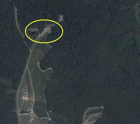
Fig. 4 – Unmistakable censoring of the POW camp location. Turnoff for the camp is visible near center of image with the insolated cluster of trees. Although Ft. AP Hill covers 158 square miles, this area appears to be the only part censored in Google maps
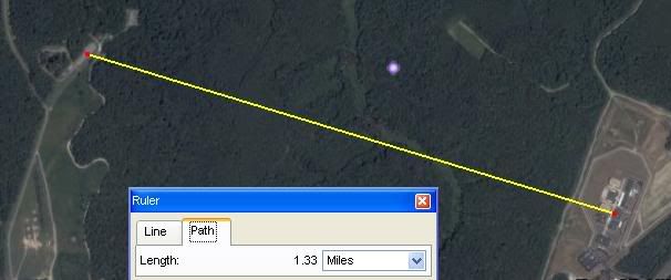
Fig.5 – Distance measurement “as the crow flies” between training complex and POW camp. This distance provides plenty of sound isolation as well.
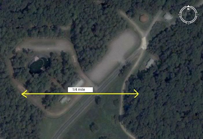
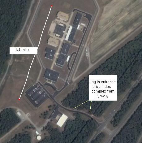
Fig. 6 – Training facility closer view. Complex shown is approximately ¼ mile long. Note that roof patterns are exact mirror images of one another. Note complete absence of vehicles around these buildings, even though a driveway runs through the complex.
Fig. 7 – Actual size of training facility from a higher altitude showing how the facility entrance is hidden from the highway. [...]

More figures with details at: www.data4science.net...
[edit on 7-4-2009 by News And History]
It is strange that people would blur out military complexes on google earth when it only attracts more attention to the site at hand.
I use google earth version 5.0.11337.1968 (beta) .
It has a feature that lets you choose different dates of photography. Some other dates have different detail. I will not tell you what I have found , I will leave it up to the viewers to look for themselves. If anyone is wondering how to look at different photo dates, open up google earth and look on the top toolbar and click on the icon that looks like a round clock. It will then bring up a slider bar to pick different dates from different years.
The different dates of this picture are 2007, 2006, and two from 2005.
I hope this helps some of you out there .
reply to post by wiredamerican
I see what you mean. I'll use that program now. Thanks for sharing those details.
I see what you mean. I'll use that program now. Thanks for sharing those details.
Got any aerial photos of POW camps that have been used as POW camps?
Sure, these could be military facilities. Sure they might be secret, or at least somewhat hidden.
Making an extrapolation to POW camps seems premature.
So, aerial photos of previously used POW camps would help identify how these facilities have been set up for comparison.
Sure, these could be military facilities. Sure they might be secret, or at least somewhat hidden.
Making an extrapolation to POW camps seems premature.
So, aerial photos of previously used POW camps would help identify how these facilities have been set up for comparison.
found some.
Fukuoka
Honami
Kashii
Stalag
More Stalag
Dachau
Ruhleben
Japanese Canadian Internment Camps
[edit on 2009/4/7 by Aeons]
Fukuoka
Honami
Kashii
Stalag
More Stalag
Dachau
Ruhleben
Japanese Canadian Internment Camps
[edit on 2009/4/7 by Aeons]
These photos are looking less like POW camps and a bit more like training camps to me, the more aerial photos I look at. With air fields.
Montana air fields
[edit on 2009/4/7 by Aeons]
Montana air fields
[edit on 2009/4/7 by Aeons]
reply to post by wiredamerican
VP Cheney blurred out his residence during his tenure at the residence. It was returned to normal once VP Biden moved in. It could be a base commander who chooses to blur out the image, or it may be for security purposes.
VP Cheney blurred out his residence during his tenure at the residence. It was returned to normal once VP Biden moved in. It could be a base commander who chooses to blur out the image, or it may be for security purposes.
The faility labeled "training facility"is actually a jail. It's called Peumansend Creek Regional
Jail It quite possibly is a CIA front. I'm just throwing this out there because several things are very peculiar about this facility.
The first thing that flagged this place for me is that it's run by something called Peumansend Creek Regional Jail Authority, which through several Northern Virginia counties send "nonviolent" prisoners to the facility.
The second thing is that facility is on federal property.
The third is that the facility is very similar in design and construction to a supposed detention facility located near Fort Belvoir, which I wrote about in the ATS post:
Secret Detention Facility in the Swamps of Northern Virginia
The first thing that flagged this place for me is that it's run by something called Peumansend Creek Regional Jail Authority, which through several Northern Virginia counties send "nonviolent" prisoners to the facility.
The Peumansend Creek Regional Jail Authority is an independent political subdivision created by the following jurisdictions located in the Commonwealth of Virginia: City of Alexandria, City of Richmond, Arlington County, Caroline County, Loudoun County, Prince William County
The second thing is that facility is on federal property.
The third is that the facility is very similar in design and construction to a supposed detention facility located near Fort Belvoir, which I wrote about in the ATS post:
Secret Detention Facility in the Swamps of Northern Virginia
Hey I live 10min from AP Hill, don't for get that right next door there is Dhalgrn (sp) The Navy's Surface warfare labs and home to a working Rail
Gun
Also Keep in mind that the National Boy Scout Jamboree is held on AP Hill, You you may be seeing is the boy scout camps, for the air I but it does look like a POW came. AP Hill is flooded ever summer by hundreds of thousands of boy scouts for this camping event held on AP.
[edit on 4/7/09 by Djdoubt03]
new topics
top topics
active topics
-
Petition Calling for General Election at 564,016 and rising Fast
Political Issues • 94 • : Freeborn -
-@TH3WH17ERABB17- -Q- ---TIME TO SHOW THE WORLD--- -Part- --44--
Dissecting Disinformation • 3384 • : brewtiger123 -
BIDEN Admin Begins Planning For January 2025 Transition to a New President - Today is 4.26.2024.
2024 Elections • 59 • : WeMustCare -
DOJ Special Counsel Robert HUR Says JOE BIDEN Can Be ARRESTED After Jan 20th 2025.
Above Politics • 30 • : WeMustCare -
On Nov. 5th 2024 - AMERICANS Prevented the Complete Destruction of America from Within.
2024 Elections • 160 • : WeMustCare -
Results of the use of the Oreshnik missile system in Dnepropetrovsk
World War Three • 240 • : 777Vader -
Both KAMALA and OBAMA are on the Nov 5th 2024 Ballot - If One Loses - Both Lose.
2024 Elections • 9 • : WeMustCare -
How many people, in GENERAL, are musically inclined?
Music • 26 • : Huronyx -
Well, here we go red lines crossed Biden gives the go ahead to use long range missiles
World War Three • 395 • : annonentity -
Federal law trumps state and local law every time
Social Issues and Civil Unrest • 30 • : ADVISOR
2