It looks like you're using an Ad Blocker.
Please white-list or disable AboveTopSecret.com in your ad-blocking tool.
Thank you.
Some features of ATS will be disabled while you continue to use an ad-blocker.

Potential evidence S4 is being blocked from our view.
page: 13
share:
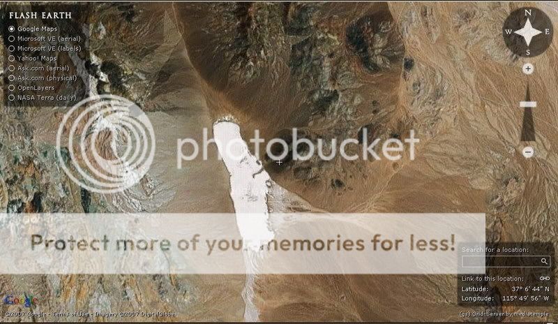
Ok, like most people I am very interested in "Area 51"/"Area S4" as well as others. I decided to compare a satellite image presented by John Lear
in This Thread
with my own using FlashEarth
Needless to say i found out something very odd. It Appears to be blocking ANY clear view. It actually goes out of it's way to.
See what I mean:
In this one it looks somewhat clear, but haven't zoomed much yet:
In this one it was very odd, in the area northwards/upwards from the "S4" area I was able to zoom in ALOT. However this is not the case when I tried to do the same to the area said by Bob Lazar to be the location of the hangars at S4:
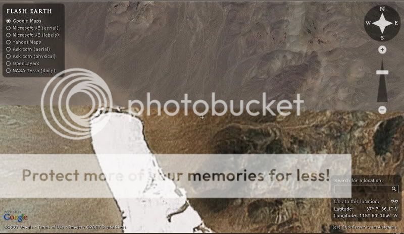
And this is Exactly where Mr. Lazar said the Hangar for S4 is:
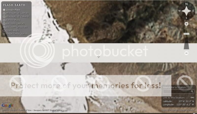
What i find most interesting is the weird white bar is positioned exactly
over where the doors/hangar is said to be. I absolutely cannot zoom in any further. I find it very odd that in most areas i can zoom in quite a bit except for this one small area.
What do you all think?
Thank you in advance
with my own using FlashEarth
Needless to say i found out something very odd. It Appears to be blocking ANY clear view. It actually goes out of it's way to.
See what I mean:
In this one it looks somewhat clear, but haven't zoomed much yet:
In this one it was very odd, in the area northwards/upwards from the "S4" area I was able to zoom in ALOT. However this is not the case when I tried to do the same to the area said by Bob Lazar to be the location of the hangars at S4:
And this is Exactly where Mr. Lazar said the Hangar for S4 is:
What i find most interesting is the weird white bar is positioned exactly
over where the doors/hangar is said to be. I absolutely cannot zoom in any further. I find it very odd that in most areas i can zoom in quite a bit except for this one small area.
What do you all think?
Thank you in advance
I get no such bar using the latest google earth browser on a Mac. Most likely a software glitch on your machine? Do you get the same anomaly using a
dedicated google browser/web browser?
My Google Earth has no such white bar across the image either.
www.picoodle.com.../7/4/9/f_s4m_aefb425.jpg
www.picoodle.com.../7/4/9/f_s4m_aefb425.jpg
Hrmm, well perhaps it was simply due to the site i was using...no idea.
Thank you for the responses.
Edit:
I downloaded google earth and used that instead of flashearth. no white bar now, however you still cannot zoom in very much. I still say they are purposely blocking any real view of it. Why is it that in so many other places you can zoom in alot, but not there?
odd.
[edit on 9-4-2007 by WhiteWash]
Well there sure is a lot of evidence of traffic that seems to just appear from that white sand, going east but there are no other tracks in or out of
the sand.
So maybe theyre driving into somewhere that can only be seen from the ground.
So maybe theyre driving into somewhere that can only be seen from the ground.
I agree Kronos...seems a little odd for all that traffic with nothing visible.
examine this close-up carefully:
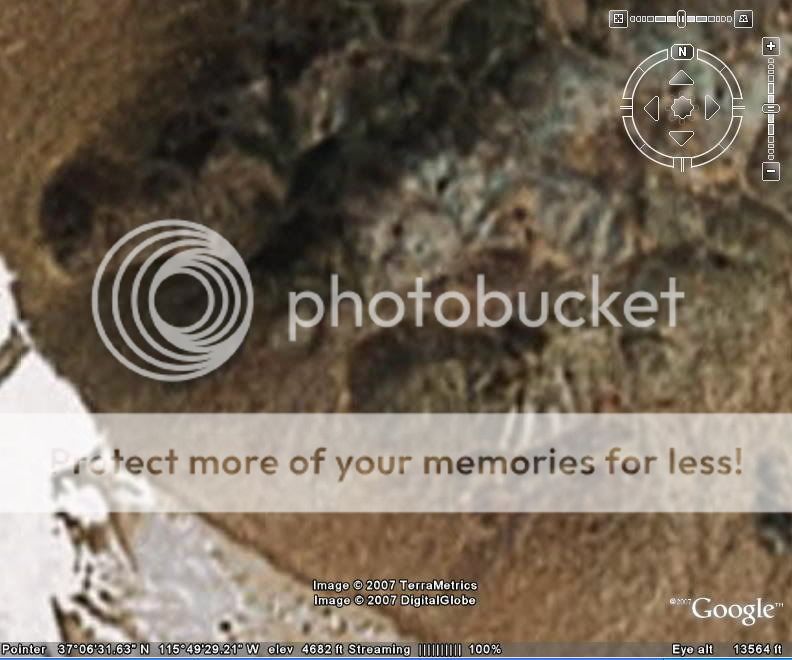
I definitely see what looks like to Me, anyway man made structures. You can see with this same photo but with my outlines the straight lines that appear to be doors, or "hangars".
Compare for yourself. Natural rock formations do not exhibit such obvious straight lined structures:
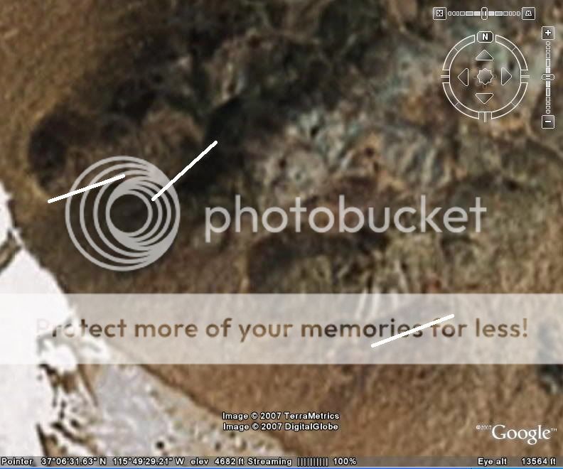
Of course, this is just my opinion, and what I see.
examine this close-up carefully:
I definitely see what looks like to Me, anyway man made structures. You can see with this same photo but with my outlines the straight lines that appear to be doors, or "hangars".
Compare for yourself. Natural rock formations do not exhibit such obvious straight lined structures:
Of course, this is just my opinion, and what I see.
Originally posted by WhiteWash
Edit:
I downloaded google earth and used that instead of flashearth. no white bar now, however you still cannot zoom in very much. I still say they are purposely blocking any real view of it. Why is it that in so many other places you can zoom in alot, but not there?
odd.
[edit on 9-4-2007 by WhiteWash]
There are a lot of places on the planet which is still displayed in very low resolution. Probably means nothing. That said, low resolution imagery would be a very convenient way of covering things up. IF there currently is such a thing as "S4" on that very location i seriously doubt it would show up on google earth or any other satelite imagery.
IMHO it would also not make very much sense to have such a location located at the same place for years and years. Eventually a place like this will pick up some interest and while it´s suitable to keep the interest up by showing off some weird lights every now and then i would surely move the really good stuff elsewhere away from prying eyes.
Remember the ballistic missile railroad network...that´s the way to go. Keeping things on a constant move make things harder to locate although it will also be easier to be spotted but that´s ok since you will be long gone a couple of days down the road.
Whitewash,
I have to respectfully disagree with you in the issue of Potential hanger sites. I just ran my own search on Google Earth, and examined the Area where you marked as a possible site for camoflaged hangers. What you are seeing is a natural rock formation. I believe that what appeared to you as a straite line, may infact have been an optical illusion. Occasionly, when the sun falls in just the right angle, and the sattelite is in the right spot, you get a shadow effect. The rock that makes up the mountains has a darker color, so if a shadow falls just right, it appears to be a part of the rock, when in fact it is not! The overlying shadow gave the illusion that there was a straight line there, when (in fact) no straight line ever existed.
I truely believe this is what you were looking at!
Respectfully,
Tim
Ghost01:
Thank you for your post.
The study of satellite imagery is one of my more extensive hobbies.
While you are obviously entitled to your opinion, you can Clearly see "lined" structures. These in my opinion are not shadows. I am quite schooled in what a shadow looks like upon the ground in sat images. The white lines i drew indicate where you should look. They clearly show the rock mass, shaped into man-made items. While I respect your right to your opinion, and thank you for it, I must disagree.
Okay, here is a perfect example. I downloaded google earth yesterday. Type in the coordinates: 62 23.5' N, 145 8.8' W - this is the HAARP
project's 2nd location. Look at the blatant difference in resolution between the south and north side of the installation. Could be a coincidence,
but it seems like their hiding something on the north side of the base.
Whitewash: the two lines which are closest together, when viewed in GE with terrain mode turned on, can be seen to both lie at the bottom of a valley.
Their apparent linearity and lighter colour could be due to a seasonal stream running down the valley.
The most southerly line is very interesting. Each end of it appears slightly raised when viewed in terrain mode.
For plenty of info and more photos see Tom Mahoods excellent website:
www.serve.com...
The most southerly line is very interesting. Each end of it appears slightly raised when viewed in terrain mode.
For plenty of info and more photos see Tom Mahoods excellent website:
www.serve.com...
collielikethedog:
I definitely see what you mean. Those coordinates are very odd..of course I know of h.a.a.r.p., and it certainly seems "smeared" to block the view. Of course some folks would have you believe it is just because some areas are in high def and some still in low def. However, as in the case of Darfur we know this is a falsehood. We are being blocked from accessing many places.
Gfad:
Yes, I agree about the most southerly line. It most certainly seems to be more than first meets the eye. Thank you for the link as well, I will take a look.
[edit on 12-4-2007 by WhiteWash]
People. S4 does indeed exist. Plain as day on Google Earth. In high res and no government coverup. If you look in the mountain range between Papoose
Lake and the crater field you'll see 2 ufo landing pads along with the now famous sand textured bay doors. Type in 37º09'37.89"N
115º55'37.79"W. Prepare to be in awe. Enjoy.
new topics
-
Russia is now saying what the 'Conspiracy Theorist' have been saying for awhile now
Mainstream News: 3 minutes ago -
Judges
Religion, Faith, And Theology: 1 hours ago -
Political Realignment: 88 Big-Business Leaders Endorse Kamala Harris
2024 Elections: 3 hours ago -
Female is Not a Feeling
Rant: 5 hours ago -
Ireland Versus England. Not looking Forward To This One
World Sports: 8 hours ago -
Psychedelic Mushrooms May Have Contributed To Early Development Of Human Consciousness
Origins and Creationism: 8 hours ago -
Meteor Burns up over Earth in Amazing Footage from Space Station
Space Exploration: 10 hours ago
top topics
-
Female is Not a Feeling
Rant: 5 hours ago, 21 flags -
Meteor Burns up over Earth in Amazing Footage from Space Station
Space Exploration: 10 hours ago, 15 flags -
Psychedelic Mushrooms May Have Contributed To Early Development Of Human Consciousness
Origins and Creationism: 8 hours ago, 12 flags -
Former Republican VP Dick Cheney Supports Harris
2024 Elections: 13 hours ago, 10 flags -
Making skin see-through; alternative to X-rays
Science & Technology: 13 hours ago, 9 flags -
Political Realignment: 88 Big-Business Leaders Endorse Kamala Harris
2024 Elections: 3 hours ago, 8 flags -
T R U T H
Music: 14 hours ago, 3 flags -
Ireland Versus England. Not looking Forward To This One
World Sports: 8 hours ago, 2 flags -
Germany Planning on Using Rwanda Scheme Built by the British for their Migrant Problem
Regional Politics: 13 hours ago, 1 flags -
Judges
Religion, Faith, And Theology: 1 hours ago, 0 flags
active topics
-
Blinken indicates he would decline any offer to stay on under Harris
Politicians & People • 22 • : TheSemiskepticII -
Russia is now saying what the 'Conspiracy Theorist' have been saying for awhile now
Mainstream News • 0 • : TheSemiskepticII -
Former Republican VP Dick Cheney Supports Harris
2024 Elections • 85 • : RickinVa -
Israel Defense Forces Shoot American Woman in the Head in Occupied West Bank
Middle East Issues • 138 • : gortex -
Female is Not a Feeling
Rant • 41 • : Hecate666 -
Father of teen suspect in Georgia school shooting charged with 2nd-degree murder
Mainstream News • 82 • : Annee -
In another world, it was the apocalypse.
Short Stories • 5 • : argentus -
Political Realignment: 88 Big-Business Leaders Endorse Kamala Harris
2024 Elections • 13 • : Lumenari -
Protect the seniors!
Rant • 11 • : lordcomac -
Lue Elizondo Announces New UFO Book "IMMINENT" Coming August 2024
Aliens and UFOs • 128 • : ratcals
3