It looks like you're using an Ad Blocker.
Please white-list or disable AboveTopSecret.com in your ad-blocking tool.
Thank you.
Some features of ATS will be disabled while you continue to use an ad-blocker.

Area 19: Setting the Facts Straight
page: 1share:
Quite often on these boards the topic of Area 19 crops up, and I wanted to create a thread where the actual facts are laid out and the myths
surrounding this portion of the Nevada Test Site are debunked.
Area 19 is a 388km2 section of the Nevada Test Site (NTS) located in the northwest corner with Area 20. Areas 19 and 20 encompass a portion of the Pahute Mesa. Both areas were added to the NTS in 1962 and designated for high yield underground nuclear tests, no atmospheric tests were performed in either region. Between 1962 and 1992 81 underground nuclear tests have been performed on the Pahute Mesa, 35 in Area 19 and 46 in Area 20.
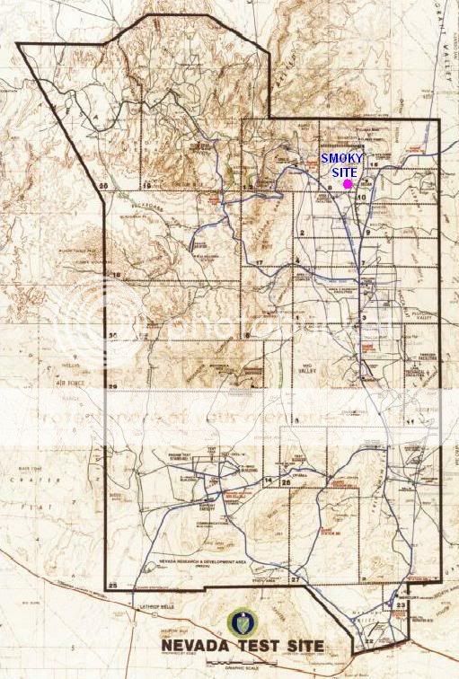
The myth of area 19 is that on an NTS map a high voltage power-line runs straight into the area from the south and terminates mysteriously right in the middle of area 19 in a loop, seemingly not connected to anything.
This has produced speculation of underground bases, disappearing runways and a variety of conspiracy theories.
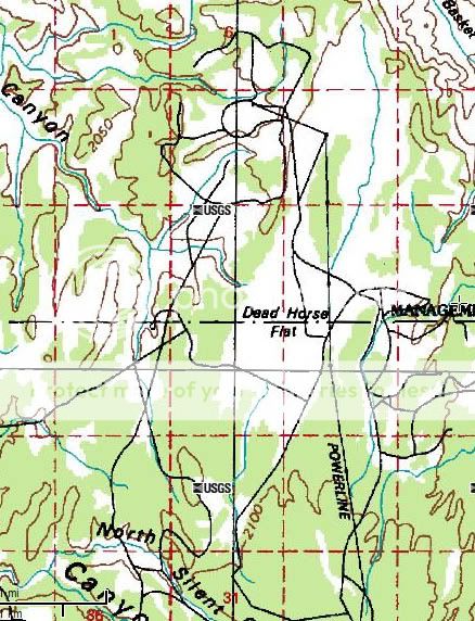
Unfortunately the entire basis for this story, the power-line, is just untrue. Here is a sample of a USGS map showing the power-line:
And true, this does end right in the middle of area 19 but here is the satellite image of the place where the power-line terminated in the loop:
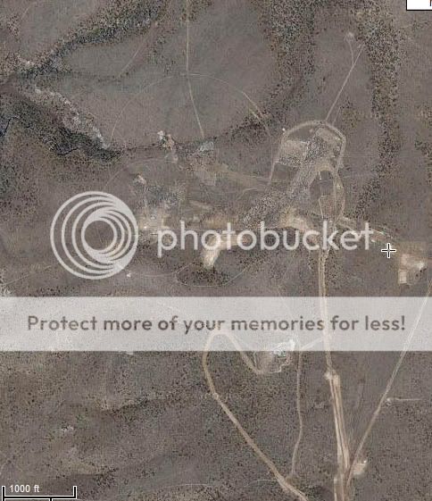
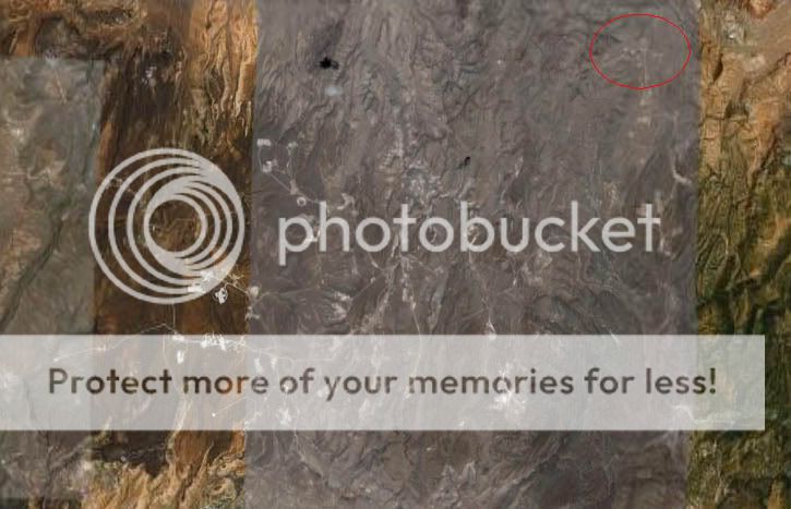
As you can see there is a lot more than nothing. In fact the power-line terminates in the exact place where three underground nuclear tests were performed, the first Chartreuse on 6th May 1966, then Mast on 19th June 1975 and finally Hosta on 12th February 1982. Also as mentioned earlier area 19 is literally packed with underground nuclear tests, here is a satellite photo with the power-line area highlighted:
To be quite honest I don’t know how the rumour started but it is pretty clear that the power-line must have been constructed at some time to support the nuclear testing or its construction.
Check out the area yourself: mapper.acme.com...,-116.31794&z=15&t=S
I hope that this might finally put this rumour to rest, and perhaps serve as a reference material, as soon as anyone mentions Area 19 point them this way!
Area 19 is a 388km2 section of the Nevada Test Site (NTS) located in the northwest corner with Area 20. Areas 19 and 20 encompass a portion of the Pahute Mesa. Both areas were added to the NTS in 1962 and designated for high yield underground nuclear tests, no atmospheric tests were performed in either region. Between 1962 and 1992 81 underground nuclear tests have been performed on the Pahute Mesa, 35 in Area 19 and 46 in Area 20.
The myth of area 19 is that on an NTS map a high voltage power-line runs straight into the area from the south and terminates mysteriously right in the middle of area 19 in a loop, seemingly not connected to anything.
This has produced speculation of underground bases, disappearing runways and a variety of conspiracy theories.
Unfortunately the entire basis for this story, the power-line, is just untrue. Here is a sample of a USGS map showing the power-line:
And true, this does end right in the middle of area 19 but here is the satellite image of the place where the power-line terminated in the loop:
As you can see there is a lot more than nothing. In fact the power-line terminates in the exact place where three underground nuclear tests were performed, the first Chartreuse on 6th May 1966, then Mast on 19th June 1975 and finally Hosta on 12th February 1982. Also as mentioned earlier area 19 is literally packed with underground nuclear tests, here is a satellite photo with the power-line area highlighted:
To be quite honest I don’t know how the rumour started but it is pretty clear that the power-line must have been constructed at some time to support the nuclear testing or its construction.
Check out the area yourself: mapper.acme.com...,-116.31794&z=15&t=S
I hope that this might finally put this rumour to rest, and perhaps serve as a reference material, as soon as anyone mentions Area 19 point them this way!
WOW! gfad, I'm really impressed!
I spent Years looking for this, and moved on because I didn't find it. Thank You for this great find, Now we can put the Cheshaire Air Strip/ Sandia Base story to rest once and for all.
I don't use my Vote for Way Above Top Secret very often, but you really earned it this time!
Tim
I spent Years looking for this, and moved on because I didn't find it. Thank You for this great find, Now we can put the Cheshaire Air Strip/ Sandia Base story to rest once and for all.
I don't use my Vote for Way Above Top Secret very often, but you really earned it this time!
Tim
Great write up...you got my vote too.
BTW This could be a great start to an investigation into area 19.
BTW This could be a great start to an investigation into area 19.
Im so glad you all found it so interesting.
Im just amazed no one has found it before!
Im just amazed no one has found it before!
Good job, gfad!
Thanks for clearing that up. I actually learned something about Area 19!
Thanks for clearing that up. I actually learned something about Area 19!
May I play Devil's Advocate ?
What if this is dis-info ?
How would we know ?
Just asking,
Lex
What if this is dis-info ?
How would we know ?
Just asking,
Lex
The USGS maps showing the "mysterious" powerline are freely available to the public (I believe). Anyone can cross reference this with Google Earth
imagery showing hundreds of nuclear testing sites within areas 19 and 20.
Furthermore, each of these blasts was equivalent to ~150kT of TNT (compare this to the Hiroshima bomb which was only equivalent to 13kT of TNT) and generated a quake registering approximately 6 on the Richter scale. This would easily register on seisometers across america and therefore can be triangulated back to independantly verify the position of each blast.
Furthermore, each of these blasts was equivalent to ~150kT of TNT (compare this to the Hiroshima bomb which was only equivalent to 13kT of TNT) and generated a quake registering approximately 6 on the Richter scale. This would easily register on seisometers across america and therefore can be triangulated back to independantly verify the position of each blast.
Playing Devil's Advocate, again.
They set off detonations that are, as you correctly state, readable by
seismology stations.
Let's theorize that the cover is that they are under-ground nukes, when
in fact, they are carving out areas using 13kt of tnt to form the places
that are going to become underground facilities.
This seems logical, and possible.
Just playing the advocate,
Lex
Originally posted by Lexion
Let's theorize that the cover is that they are under-ground nukes, when
in fact, they are carving out areas using 13kt of tnt to form the places
that are going to become underground facilities.
This seems logical, and possible.
I think you mean 150kT, the 13kT bomb was the Hiroshima bomb, the tests were much larger blasts.
I dont think its logical to try to build a base using nuclear explosions. What happens is so uncontrolable the cavity formed tends to simply collapse and destabilse the surrounding area. Simple digging is a much better idea IMO.
Heres a diagram showing the effects of an underground nuke test:
Heres an image of an underground test site, this was only a 20kT blast so much smaller than the ones in area 19. You can clearly see the collapse:
Hi GFAD,
Great post! Something still smells a little weird here though. I don't believe the cheshire airstrip story and I certainly don't think there are reptilians wandering around under the earth waiting to return to the surface!
Having said that, what would those power lines be used to power? I know at first that sounds like a rather stupid question but why would you run high voltage lines across miles and miles of desert when a simple onsite generator (large trailer style) would probably do the job of lighting, A/C, small cranes, lifts etc? Surely if you were creating a temporary facility then a genny would be fine, you'd only install long distance HT lines for a more permanent facility?
Do all of the other test sites also have the same supply? I'd look for myself but I wouldn't know where to find the USGS data etc.
Just my two penneth worth!
Cheers
Rob
Originally posted by stratsys-sws
Having said that, what would those power lines be used to power? I know at first that sounds like a rather stupid question but why would you run high voltage lines across miles and miles of desert when a simple onsite generator (large trailer style) would probably do the job of lighting, A/C, small cranes, lifts etc? Surely if you were creating a temporary facility then a genny would be fine, you'd only install long distance HT lines for a more permanent facility?
Do all of the other test sites also have the same supply? I'd look for myself but I wouldn't know where to find the USGS data etc.
Good point. Yet these underground nuclear tests arent simply covered with dirt, they are up to 700m underground in the bedrock.
Digging shafts this deep requires a sizeble construction site and staff over a considerable amount of time. I dont think a generator would supply such requirements.
Hi,
Yeah I agree they are pretty big efforts but so are portable generator sets nowadays. Just a few of these 2,200 kVa sets on site should be ample for all but the most massive projects, and far far cheaper and resuable than a power line? Pehaps cost isn't an issue but flexibility and project start up times surely are?
On the other hand, if this really were a top secret underground facility then why not just bury the cables?
Cheers
Rob
I doubt the drilling rig uses electricity. I would assume it is diesel powered. I will try to find someone in the "reading room" to inquire about
why they need these HV lines. I'm scheduled for a NTS tour soon.
If you look at Project Faultless, no power lines were used. There was a "petro" cleanup of sorts, i.e. there were signs in the area that read something like petroleum laden soil or something to that effect. I don't have photos of those signs. I believe the oil contamination was due to diesel from the drilling rig.
www.lazygranch.com/projfault.htm
My guess on why run wire instead of a local generator is EMP effects.
My opinion is that the power line was originally placed there for directed energy weapons experiments. The ‘nuclear bomb’ tests, if any, were just
disinformation.
I believe the power was also used in the construction of the enormous underground base known as Sandia, the original construction of which was performed between 1980 and 1987.

The entire base is underground. There is a secret landing strip oriented as I have shown here. It is one of those strips, the terrain of which “unzips” for landing. A huge elevator then lowers the airplane to a lower level as the terrain ‘zips’ back up.
To the north of Sandia are the new “Groom Lake” strips. There are 2 parallel runways with a large, long hangar in the middle. The hangar is divided in 2 sections lengthwise by a wall. Apparently whatever is in one section of the hangar is kept secret from whatever is in the other section.
This is a regular multi-daily stop for the Special Projects Boeing 737’s.
One interesting thing seen around this base is small igloo shaped buildings each of which is guarded at all times by 2 heavily armed personnel. There is also a generator to the rear of the igloo that is constantly running. There is a rectangular shaped ‘hangar’ door at the front of the ‘igloo’.
The approximate size of the ‘igloo’ which is covered with a texture resembling sand is about 10 feet high and about 30 feet in diameter.
I have no information what is in these ‘igloos’. There are about 10 of them at Station 9.
The above information, which I believe to be true and accurate, is based on information given to me by various test site workers over the past 30 years.
I call the area I have labeled as "Station 9" because that is what the Boeing 737 calls it when he contacts Nellis Control inbound.
I believe the power was also used in the construction of the enormous underground base known as Sandia, the original construction of which was performed between 1980 and 1987.
The entire base is underground. There is a secret landing strip oriented as I have shown here. It is one of those strips, the terrain of which “unzips” for landing. A huge elevator then lowers the airplane to a lower level as the terrain ‘zips’ back up.
To the north of Sandia are the new “Groom Lake” strips. There are 2 parallel runways with a large, long hangar in the middle. The hangar is divided in 2 sections lengthwise by a wall. Apparently whatever is in one section of the hangar is kept secret from whatever is in the other section.
This is a regular multi-daily stop for the Special Projects Boeing 737’s.
One interesting thing seen around this base is small igloo shaped buildings each of which is guarded at all times by 2 heavily armed personnel. There is also a generator to the rear of the igloo that is constantly running. There is a rectangular shaped ‘hangar’ door at the front of the ‘igloo’.
The approximate size of the ‘igloo’ which is covered with a texture resembling sand is about 10 feet high and about 30 feet in diameter.
I have no information what is in these ‘igloos’. There are about 10 of them at Station 9.
The above information, which I believe to be true and accurate, is based on information given to me by various test site workers over the past 30 years.
I call the area I have labeled as "Station 9" because that is what the Boeing 737 calls it when he contacts Nellis Control inbound.
Sounds like pure fantasy, John.
Your so-called Sandia base location is a part of Area 19 that has seen some pretty large nuclear blasts. Check out the latest satellite imagery for a clear view oif some of the subsidence craters. Pretty rugged terrain for an airstrip for that matter.
"Station 9" appears to be a large bombing target on a dry lakebed. It is surrounded by numerous other well-used targets on the Nevada Test and Training Range.
"S-4" also appears to be a no-show. High-resoulution satellite images show a whole lot of nothing around Papoose Lake. There is not even a place to build "hidden hangars in the mountainside adjacent to the lakebed." There is only a gently sloping fan of alluvium and a few sparsely-used dirt roads.
Originally posted by Shadowhawk
Thanks for the post shadowhawk. You may not be aware of it but all satellite images are photo-shopped of anything even slightly secret. The clear photos of Groom Lake were deliberately used to mislead the public about current projects.
Groom Lake is used for only one thing these days and that is to divert the attention of the public.
But thanks for the post and how are things going over there at NASA?
Sounds like pure fantasy, John. Check out the latest satellite imagery for a clear view oif some of the subsidence craters. Pretty rugged terrain for an airstrip for that matter.
Thanks for the post shadowhawk. You may not be aware of it but all satellite images are photo-shopped of anything even slightly secret. The clear photos of Groom Lake were deliberately used to mislead the public about current projects.
Groom Lake is used for only one thing these days and that is to divert the attention of the public.
But thanks for the post and how are things going over there at NASA?
Originally posted by johnlear
Originally posted by Shadowhawk
Thanks for the post shadowhawk. You may not be aware of it but all satellite images are photo-shopped of anything even slightly secret. The clear photos of Groom Lake were deliberately used to mislead the public about current projects.
Do you have proof that "all" satellite images are photo shopped, or should I take your word for it because you are John Lear, I'm sorry I'm having a hard time believing that. Are there not private companies that have satellite photos also. Are they also photo shopped. Not trying to be a pain, just want to know.
I would think....if they are going through the trouble to build an underground base.....then I would assume they would run the power lines underground
as well...I mean its logical right? I agreed with GFAD, Why risk loss of power to a whole underground base with exposed aerial wire? I mean common
sense guys, they probably were put in for the nuke test sites, aerial quick to install over any terrain to the nuke site.
new topics
-
4/27/24 New Jersey Earthquake
Fragile Earth: 2 hours ago -
Fun with extreme paints
Interesting Websites: 4 hours ago -
CIA is alleged to be operat social media troll frms in Kyiv
ATS Skunk Works: 5 hours ago -
Rainbow : Stargazer
Music: 5 hours ago -
I sleep no more.
Philosophy and Metaphysics: 8 hours ago -
Canada caught red-handed manipulating live weather data and make it warmer
Fragile Earth: 8 hours ago -
Why Files Our Alien Overlords | How We Secretly Serve The Tall Whites
Aliens and UFOs: 9 hours ago -
Curse of King Tuts Tomb Solved
Ancient & Lost Civilizations: 11 hours ago -
What allies does Trump have in the world?
ATS Skunk Works: 11 hours ago
top topics
-
Canada caught red-handed manipulating live weather data and make it warmer
Fragile Earth: 8 hours ago, 16 flags -
Why Files Our Alien Overlords | How We Secretly Serve The Tall Whites
Aliens and UFOs: 9 hours ago, 10 flags -
Curse of King Tuts Tomb Solved
Ancient & Lost Civilizations: 11 hours ago, 8 flags -
4/27/24 New Jersey Earthquake
Fragile Earth: 2 hours ago, 5 flags -
What allies does Trump have in the world?
ATS Skunk Works: 11 hours ago, 4 flags -
I sleep no more.
Philosophy and Metaphysics: 8 hours ago, 4 flags -
CIA is alleged to be operat social media troll frms in Kyiv
ATS Skunk Works: 5 hours ago, 4 flags -
Rainbow : Stargazer
Music: 5 hours ago, 1 flags -
Fun with extreme paints
Interesting Websites: 4 hours ago, 1 flags
active topics
-
CIA is alleged to be operat social media troll frms in Kyiv
ATS Skunk Works • 21 • : YourFaceAgain -
University of Texas Instantly Shuts Down Anti Israel Protests
Education and Media • 354 • : CriticalStinker -
Fun with extreme paints
Interesting Websites • 4 • : GeorgeVanTassel -
James O’Keefe: I have evidence that exposes the CIA, and it’s on camera.
Whistle Blowers and Leaked Documents • 26 • : GeorgeVanTassel -
Gold and silver prices....woo hoo
History • 89 • : lilzazz -
Silent Moments --In Memory of Beloved Member TDDA
Short Stories • 75 • : zosimov -
4/27/24 New Jersey Earthquake
Fragile Earth • 3 • : Hakaiju -
Ireland VS Globalists
Social Issues and Civil Unrest • 13 • : StoutBroux -
The State Intelligence Directorate of Ukraine tried to blow up churches in Russia on Easter
War On Terrorism • 23 • : ScottKirkland -
Democrats have Reduced using the term Bidenomics and Republicans have Increased
2024 Elections • 10 • : hovejo4021