It looks like you're using an Ad Blocker.
Please white-list or disable AboveTopSecret.com in your ad-blocking tool.
Thank you.
Some features of ATS will be disabled while you continue to use an ad-blocker.

Google Earth (Prime Meridian)
page: 10
share:
I have a question I am hoping someone can answer for me. I was on google earth. I went to the extreme north pole and zoomed in on a hole which has no
longitude or lattitude just prime meridian, I zoomed in and noticed that this hole continues to go deeper and deeper into the earth from the north
pole, straight through to the south pole. (I did the search again from extreme south pole and found there is a hole there, can anyone tell me why the
earth has this hole in it that goes completely through the earth from top to bottom. If you go to google earth you will notice that the earth starts
to look like it is caving in towards the center on either side of the planet. Can someone help my fragile mind?
Thanks,
Justmytype
Thanks,
Justmytype
I doubt such a whole exists insofar as the core of the earth is molten, but if you had a link or two, it would probably help the geologically-minded
to give you an answer.
Sorry, Go to google Earth, then go to these coordinates.
N89 degree 59, when map zooms in, directly above will be a hole and prime meridian, zoom in on this hole, notice, light in center, rainbow colors shooting up!
just check it out and let me know what this is.
N89 degree 59, when map zooms in, directly above will be a hole and prime meridian, zoom in on this hole, notice, light in center, rainbow colors shooting up!
just check it out and let me know what this is.
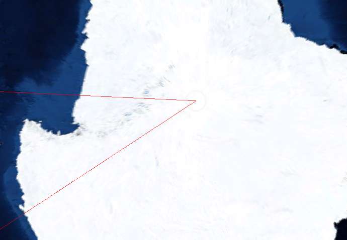
This is the north pole at extreme zoom.

Is this what your talking about ?
Is this what your talking about ?
That is exactlly what I am talking about. What is it and how come it can be found on both poles?
The image tiles that make up the polar regions are triangular and all are knit together right on the pole. I also get the feeling that most of the
polar images are taken from an angle rather than a direct fly-over, so that may add to the distortion.
You can see a data tile being downloaded to my computer in this screen capture of NASA World Wind.
Your not seeing a hole in the Earth, just a hole in the data.
You can see a data tile being downloaded to my computer in this screen capture of NASA World Wind.
Your not seeing a hole in the Earth, just a hole in the data.
Thank you for clearing that up for me, your knowledge is ver much appreciated!
new topics
-
Boy Scouts to be renamed next year
Other Current Events: 1 hours ago -
Pfizer agrees to settle over 10,000 Zantac lawsuits after cancer causing substance found in drug
Medical Issues & Conspiracies: 1 hours ago -
Judas Iscariot Slips The Hangman's Noose
Political Issues: 4 hours ago -
Murder Suicide Investigation Still Active 4 months later?
Other Current Events: 5 hours ago -
A Shout-out To truthseeker45 Hoot Hoot
General Chit Chat: 6 hours ago -
Ooooh...it worked!!
Members: 9 hours ago -
New House GOP Bill To Send Pro Hamas College Law Breakers to Gaza for 6 Months
Social Issues and Civil Unrest: 11 hours ago
top topics
-
Court of Appeals Agrees to Hear Trump Appeal to Flush Fani Willis
US Political Madness: 15 hours ago, 15 flags -
Ooooh...it worked!!
Members: 9 hours ago, 15 flags -
President Bidens Health is Declining Faster 5.8.2024 - He Should Stay Home.
2024 Elections: 14 hours ago, 9 flags -
New House GOP Bill To Send Pro Hamas College Law Breakers to Gaza for 6 Months
Social Issues and Civil Unrest: 11 hours ago, 9 flags -
Judas Iscariot Slips The Hangman's Noose
Political Issues: 4 hours ago, 8 flags -
A Shout-out To truthseeker45 Hoot Hoot
General Chit Chat: 6 hours ago, 4 flags -
Murder Suicide Investigation Still Active 4 months later?
Other Current Events: 5 hours ago, 2 flags -
Pentagon UFO Hunter Reveals What He Knows About Aliens: Nothing
Aliens and UFOs: 13 hours ago, 2 flags -
Pfizer agrees to settle over 10,000 Zantac lawsuits after cancer causing substance found in drug
Medical Issues & Conspiracies: 1 hours ago, 2 flags -
Boy Scouts to be renamed next year
Other Current Events: 1 hours ago, 1 flags
active topics
-
Russia Ukraine Update Thread - part 3
World War Three • 5765 • : F2d5thCavv2 -
The Vaccine Injured
Medical Issues & Conspiracies • 30 • : PrivateAngel -
Ooooh...it worked!!
Members • 10 • : angelchemuel -
Don’t Obstruct the Leftist Implosion
US Political Madness • 32 • : Terpene -
New whistleblower Jason Sands speaks on Twitter Spaces last night.
Aliens and UFOs • 125 • : baablacksheep1 -
New House GOP Bill To Send Pro Hamas College Law Breakers to Gaza for 6 Months
Social Issues and Civil Unrest • 83 • : Asher47 -
A Note Found On A Windshield in Italy.
General Conspiracies • 83 • : AdultMaleHumanUK -
Boy Scouts to be renamed next year
Other Current Events • 1 • : FlyersFan -
The More things Change The More They stay the Same
Above Politics • 5 • : Hemanth -
Black kids in the Bronx don't know what the word 'computer' is
People • 16 • : GotterDameron23
0