It looks like you're using an Ad Blocker.
Please white-list or disable AboveTopSecret.com in your ad-blocking tool.
Thank you.
Some features of ATS will be disabled while you continue to use an ad-blocker.

Curiosity Mars Rover Reaches Gediz Vallis Ridge (360 View)
page: 115
share:
Curiosity completed an arduous climb this week to Gediz Vallis Ridge on the 3-mile-tall Mount Sharp , while parked up the rover took this zoomable ,
rotatable image just for you.
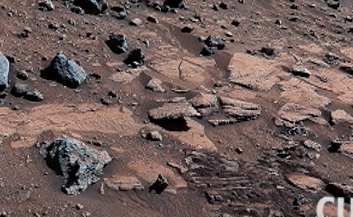
Drag your mouse to look around within this 360-degree panorama captured by NASA’s Curiosity Mars rover. See the steep slopes, layered buttes, and dark rocks surrounding Curiosity while it was parked below Gediz Vallis Ridge, which formed as a result of violent debris flows that were later eroded by wind into a towering formation. This happened about 3 billion years ago, during one of the last wet periods seen on this part of the Red Planet.
On Aug. 19, 2023, Curiosity’s Mastcam took 136 images that were stitched together into this mosaic after being sent back to Earth. The color has been adjusted to match lighting conditions as the human eye would see them on Earth.
edit on 22-9-2023 by gortex because: edit to add
a reply to: KKLOCO
Most likely due to wast oceans at one point that distributed these rocks around the edges of Lake beds or something.
Probably why they put the landers to close to study things that could indicate previous life forms at some point.
Kinda like finding shells and such at the beach.
I'm no expert but just my guess.
Very solid hypothesis. Most deserts on Earth were once water bodies.
Even Death Valley was a massive pre-historic lake, only 128,000 to 186,000 years ago.
a reply to: Stopstealingmycountry
Even Death Valley was a massive pre-historic lake, only 128,000 to 186,000 years ago.
a reply to: Stopstealingmycountry
a reply to: TheValeyard
I appreciate your gratitude to my very uneducated hypothesis!
I guess also a possible grand and great overland adventure would be to test and prove robotic mobility in such a terrain.
I appreciate your gratitude to my very uneducated hypothesis!
I guess also a possible grand and great overland adventure would be to test and prove robotic mobility in such a terrain.
originally posted by: Stopstealingmycountry
a reply to: KKLOCO
Most likely due to wast oceans at one point that distributed these rocks around the edges of Lake beds or something.
Not very likely, as water would have eroded the rocks in ways we do not see on these.
In other places they have found rocks and dust typical of lake beds.
To me, these look more like they were broken by changes in temperature.
Probably why they put the landers to close to study things that could indicate previous life forms at some point.
Kinda like finding shells and such at the beach.
I'm no expert but just my guess.
That's why they chose that location, because it looks like Mount Sharp was created by the accumulation of sediments brought to Gale crater by relatively large water flows.
a reply to: TheValeyard
The Sahara was once a vast ocean. See: Graveyard of the Whales
Half billion year old fossils are an industry in the North West Sahara. There are quarries that cut beautiful stone full of fossils that wind up being someones kitchen counter tops. All under the dunes.
I brought back a starfish fossil for my surfing, salty son.
edit on 9/23/2023 by CoyoteAngels because: (no reason given)
originally posted by: ArMaP
originally posted by: Stopstealingmycountry
a reply to: KKLOCO
Most likely due to wast oceans at one point that distributed these rocks around the edges of Lake beds or something.
Not very likely, as water would have eroded the rocks in ways we do not see on these.
In other places they have found rocks and dust typical of lake beds.
To me, these look more like they were broken by changes in temperature.
That's why they chose that location, because it looks like Mount Sharp was created by the accumulation of sediments brought to Gale crater by relatively large water flows.
An apocalyptic event maybe? Mars, I think is a much, much older planet than earth by a long shot, it most certainly had water at some time. If Mars's (green surface) was blown away by some big event, it may have had orbital change as well.
When you look at Gortex's picture a centrepiece has what 'looks like' a sedimentary rock shelf hanging there and typical of many rocks you look at elsewhere on Mars, and if you stood on it, it would just crumble to dust, an aboriginal piece of rock, and no matter if sediment formed, or just so old in decay from millennia.
new topics
-
James O keefe from Veritas controlled opposition.
Medical Issues & Conspiracies: 2 hours ago -
Political Commentator Alice Stewart Supposedly Died of Natural Causes on a Sidewalk Last Night.
General Conspiracies: 2 hours ago -
BIG REVEAL | Intelligence advisor says ‘catastrophic disclosure’ about UFOs may be on horizon
Aliens and UFOs: 2 hours ago -
Madness will ensue here. Be ready.
General Chit Chat: 3 hours ago -
FO!!! FO!! FO!!...dammit!!
Food and Cooking: 4 hours ago -
The Rift
Fantasy & Science Fiction: 6 hours ago -
Would you give part of your liver to someone who needed it but could not stop drinking?
General Chit Chat: 6 hours ago -
Scientists assaulted at Skinwalker Ranch (Bigelow era)
Aliens and UFOs: 11 hours ago
top topics
-
Cool video of bees protecting other bugs
General Chit Chat: 12 hours ago, 11 flags -
Mods Are Sleeping: Let's Post Protists!
General Chit Chat: 13 hours ago, 8 flags -
Madness will ensue here. Be ready.
General Chit Chat: 3 hours ago, 5 flags -
The horse
Jokes, Puns, & Pranks: 13 hours ago, 4 flags -
Scientists assaulted at Skinwalker Ranch (Bigelow era)
Aliens and UFOs: 11 hours ago, 4 flags -
BIG REVEAL | Intelligence advisor says ‘catastrophic disclosure’ about UFOs may be on horizon
Aliens and UFOs: 2 hours ago, 4 flags -
Political Commentator Alice Stewart Supposedly Died of Natural Causes on a Sidewalk Last Night.
General Conspiracies: 2 hours ago, 3 flags -
FO!!! FO!! FO!!...dammit!!
Food and Cooking: 4 hours ago, 3 flags -
The Rift
Fantasy & Science Fiction: 6 hours ago, 2 flags -
Would you give part of your liver to someone who needed it but could not stop drinking?
General Chit Chat: 6 hours ago, 2 flags
active topics
-
BIG REVEAL | Intelligence advisor says ‘catastrophic disclosure’ about UFOs may be on horizon
Aliens and UFOs • 16 • : Ophiuchus1 -
Biden accepts Trumps debate challenge
2024 Elections • 196 • : Zanti Misfit -
Alex Jones admits Sandy Hook school shooting is '100% real' after claiming it was a hoax
Conspiracy Theorists • 148 • : Zanti Misfit -
1st Jewish Biden Appointee to Resign Over Gaza Quits on Nakba Day
Political Issues • 76 • : Degradation33 -
WHY is DOJ Not Turning Over the AUDIO of JOE BIDENs Sworn Testimony to Prosecutor Robert Hur.
Above Politics • 34 • : WeMustCare -
Alex Jones: Vote Donald Trump If You Wanna Live
Conspiracy Theorists • 46 • : Zanti Misfit -
65 percent of young British Muslims oppose Israel’s right to exist - shocking new poll...
Conspiracies in Religions • 16 • : Ohanka -
Tick...tock...What one thing on ATS?
General Conspiracies • 106 • : SchrodingersRat -
Remember These Attacks When President Trump 2.0 Retribution-Justice Commences.
2024 Elections • 72 • : spacedoubt -
Want Some Secret Knowledge?
Paranormal Studies • 45 • : Compendium
15