It looks like you're using an Ad Blocker.
Please white-list or disable AboveTopSecret.com in your ad-blocking tool.
Thank you.
Some features of ATS will be disabled while you continue to use an ad-blocker.
6.5 magnitude earthquake hits Nevada near Area 51 - Largest area Nevada earthquake in 65 years
page: 1share:
6.5 magnitude earthquake hits Nevada near Area 51; quake felt from Utah to California
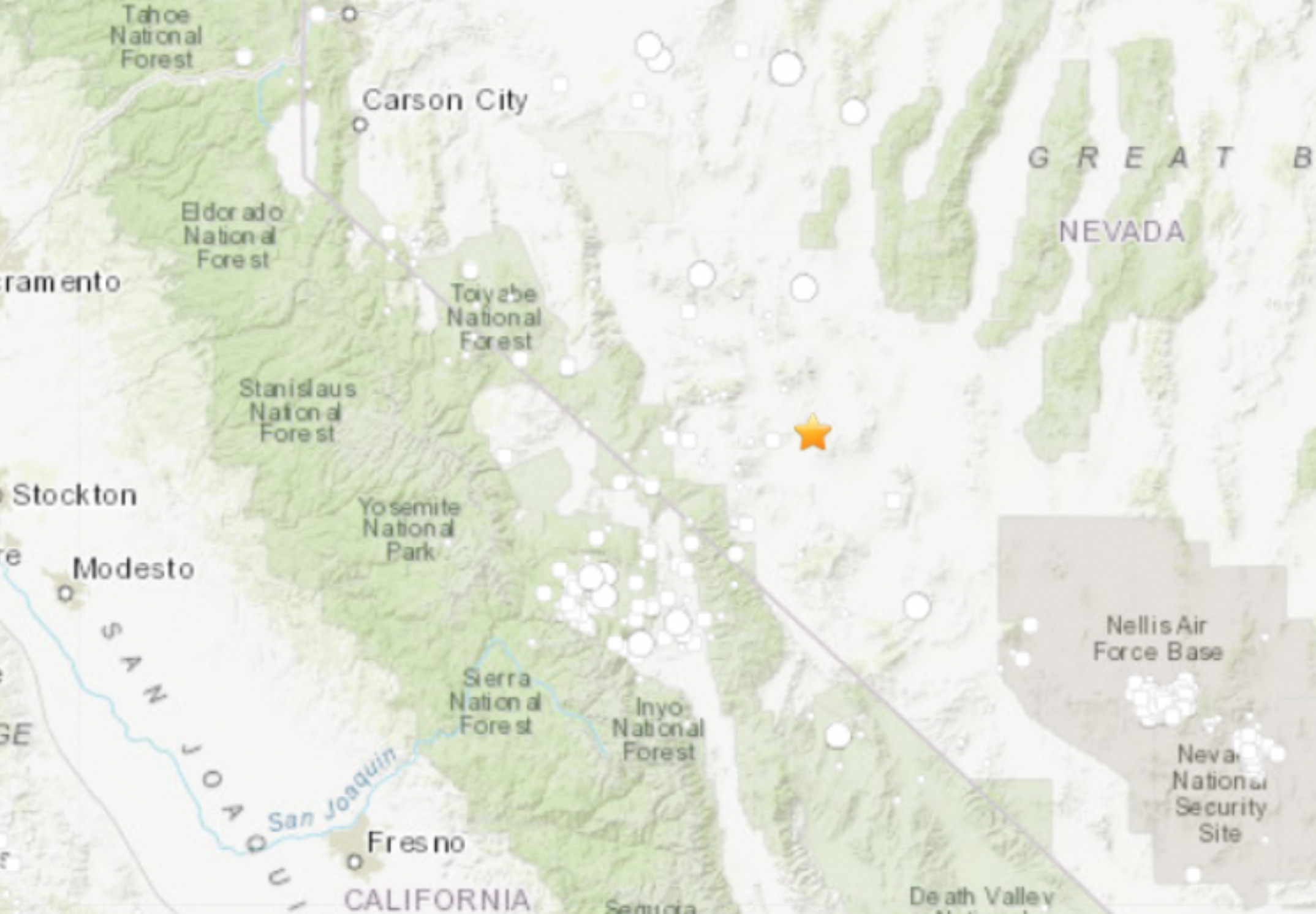
A magnitude 6.5 earthquake struck in remote western Nevada early Friday, according to the U.S. Geological Service, shaking people from Utah to California — and some pointing out it happened near Area 51.
The temblor was reported at 4:03 a.m. about 35 miles outside Tonopah, just east of the Sierra Nevada range. First recorded as a 6.4 earthquake, the USGS later upgraded it to a 6.5 magnitude.
The initial quake struck about 4.7 miles deep, the USGS said, and at least six sizable aftershocks were recorded shortly thereafter, including two with estimated magnitudes of 5.4. The USGS has advised that Nevada will continue to experience more earthquakes than usual as aftershocks continue throughout the day.
This quake reportedly was not under any military land. Unlike the quake not too long ago at China Lake.
Most people in the area were asleep when the quake hit. Many reported they were awakened by the quake.
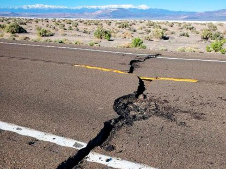
Looks like it cracked a main highway.
No injuries were reported, but officials said goods tumbled from market shelves, sidewalks heaved and storefront windows cracked shortly after 4 a.m. People from Salt Lake City to California’s Central Valley tweeted that they felt the quake.
Nevada Highway Patrol photos showed cracks on U.S. 95 before crews repaired them about 35 miles (56 kilometers) west of Tonopah. A detour to State Route 360 had added more than 20 miles (32 kilometers) to motorists' trips.
The vast open range east of the snow-capped Sierra Nevada is seismically active, said Graham Kent, director of the Nevada Seismological Lab at the University of Nevada, Reno. He ranked Friday's event with twin December 1954 earthquakes at Fairview Peak and Dixie Valley. Kent said those temblors were magnitudes 7.1 and 6.8, respectively.
Largest area Nevada earthquake in 65 years cracks main highway between Las Vegas and Reno
The roadway was opened back up Friday after being closed for about 10 hours. The quake hit before sunrise.
edit on 15-5-2020 by LookingAtMars because: add pics/fix quote/fix title
a reply to: LookingAtMars
I am glad there were no Deaths. They would have added them to covid list probably.
I am glad there were no Deaths. They would have added them to covid list probably.
My city is pictured on that map, but I didn't feel anything. Im in Cali
a reply to: visitedbythem
Were you sleeping one off this AM? lol.
Thanks for reporting that. Interested to see if anyone on ATS felt it.
Were you sleeping one off this AM? lol.
Thanks for reporting that. Interested to see if anyone on ATS felt it.
I awoke to the shaking, looked at the clock 4:04am (clock was probably off), and I was amused at the time "404". Yes indeed an earthly 404 error! I'm
close to the Sierra Mountains in California.
Johnny
Johnny
There was another large aftershock of 4.4 in Idaho on Wednesday...
What is going on?
What is going on?
originally posted by: LookingAtMars
a reply to: abeverage
I hope it is just normal activity.
The vast open range east of the snow-capped Sierra Nevada is seismically active
They also had a 6.5 which the last was 40 years ago and like this one very rare...makes me wonder what is going on below...
Oh wow. I didn't get a notification about this quake on my app. That was a big one.
originally posted by: JohnnyAnonymous
I awoke to the shaking, looked at the clock 4:04am (clock was probably off), and I was amused at the time "404". Yes indeed an earthly 404 error! I'm close to the Sierra Mountains in California.
Johnny
Thanks for the report.
Did you notice anything unusual this morning after you got up?
originally posted by: LookingAtMars
originally posted by: JohnnyAnonymous
Thanks for the report.
Did you notice anything unusual this morning after you got up?
Not that I noticed. When it happened I was having a great dream, and then awoke from the shaking which lasted maybe 5 or 6 seconds after being first awakened.
SO sorry.. Didn't hear any animals, nothing was broken in the house, nothing fell down, but it was a strong enough quake to wake my dreamy azz up (that didn't come out right, my bum is not dreamy at all).
edit on 5/15/2020 by JohnnyAnonymous because: (no reason given)
Don't worry, momma nature probably isn't trying to save herself at our expense.
It's probably not the DUMBs getting nuked to eradicate the lizard people, their child slaves and experimental halls of hell, either.
It's probably just a plain ol' run of the mill dormant fault line waking up.
It's probably not the DUMBs getting nuked to eradicate the lizard people, their child slaves and experimental halls of hell, either.
It's probably just a plain ol' run of the mill dormant fault line waking up.
a reply to: LookingAtMars
Something to consider with the activity from last July’s big twin quakes in China Lake, to swarms in Mono lake and Salton Sea areas. And now this big one near the newly proposed Walker Lane.
BTW, the aftershocks from the Nevada quake are reaching toward the Mono Lake swarm.
You guys hear of Walker Lane? Wiki
Here is a bit more colorful story about Walker Lane.
Move Over, San Andreas: There’s an Ominous New Fault in Town
But we have some time, right?
Walker Lane YT video
Something to consider with the activity from last July’s big twin quakes in China Lake, to swarms in Mono lake and Salton Sea areas. And now this big one near the newly proposed Walker Lane.
BTW, the aftershocks from the Nevada quake are reaching toward the Mono Lake swarm.
You guys hear of Walker Lane? Wiki
The Walker Lane is a geologic trough roughly aligned with the California/Nevada border southward to where Death Valley intersects the Garlock Fault, a major left lateral, or sinistral, strike-slip fault.
The Walker Lane takes up 15 to 25 percent of the boundary motion between the Pacific Plate and the North American Plate, the other 75 percent being taken up by the San Andreas Fault system to the west.[4][5] The Walker Lane may represent an incipient major transform fault zone which could replace the San Andreas as the plate boundary in the future.[6][3]
Here is a bit more colorful story about Walker Lane.
Move Over, San Andreas: There’s an Ominous New Fault in Town
An emerging fault system along the Nevada border is shaking up the tech industry’s latest frontier—and only a small group of scientists is paying attention.
But for James Faulds, Nevada’s state geologist, they are something more—clues to a great tectonic mystery unfolding in the American West. If he’s right, all of this, from the wastes of the Mojave Desert to the night-lit casinos of Reno, will someday be beachfront property.
But we have some time, right?
. It’s an emerging zone of instability, known as the [b[Walker Lane, that closely follows Route 395. He believes that, over the next 8 million to 10 million years, the North American continent will unzip along this stretch of land, east of the San Andreas. The Gulf of California, which separates the Baja Peninsula from Mexico, will surge north into Nevada, turning thousands of square miles of dry land into ocean floor. (Mapmakers, if they still exist, may label the new body of water the Reno Sea.)
Walker Lane YT video
edit on 15-5-2020 by Observationalist because: (no reason given)
edit on 15-5-2020 by Observationalist because: (no reason
given)
a reply to: Observationalist
I am guessing that would be a very disruptive replacement.
How fast could the replacement happen?
Thanks, great post. You should of done an OP.
which could replace the San Andreas as the plate boundary in the future
I am guessing that would be a very disruptive replacement.
How fast could the replacement happen?
Thanks, great post. You should of done an OP.
Movement in the N Am Craton with the earthquake in the MOntecristo volcanic fields.. the whole thing is moving to the East. TO the west its sliding,
to the east its moving.. Tn just had one.. and prob see some toward the east coast now. I am terrible at explaining what Im trying to say, so here is
a video thats is sort of what I mean.. but a LOT more info!
The ring of fire has lit up.. and there are clusters of quakes in those caldera regions.. plus Mt Helens and Ranier are on the move.. I just learned that from this video too.
The ring of fire has lit up.. and there are clusters of quakes in those caldera regions.. plus Mt Helens and Ranier are on the move.. I just learned that from this video too.
originally posted by: burdman30ott6
Who has Yellowstone Megaquake in 2020's Apocalyptic Bingo?
2020 is just getting its revenge on behalf of 2012 and 2000... and practically all Jehovah's Wintesses' doomer dates.
new topics
-
Merry-Go-Round Ride
Short Stories: 1 hours ago -
It's toast
General Chit Chat: 5 hours ago -
Man Stabbed or Cardiac arrest on Westminster Bridge, London, UK
Mainstream News: 6 hours ago -
A fix for the Trans players in sports
Social Issues and Civil Unrest: 8 hours ago -
Petition Calling for General Election at 564,016 and rising Fast
Political Issues: 11 hours ago
top topics
-
Petition Calling for General Election at 564,016 and rising Fast
Political Issues: 11 hours ago, 14 flags -
A fix for the Trans players in sports
Social Issues and Civil Unrest: 8 hours ago, 14 flags -
Rep. Alexandria O. Cortez Says Forcing People to Use The Correct Bathroom is Dangerous.
US Political Madness: 17 hours ago, 8 flags -
Man Stabbed or Cardiac arrest on Westminster Bridge, London, UK
Mainstream News: 6 hours ago, 7 flags -
It's toast
General Chit Chat: 5 hours ago, 7 flags -
Merry-Go-Round Ride
Short Stories: 1 hours ago, 1 flags
active topics
-
Merry-Go-Round Ride
Short Stories • 1 • : JJproductions -
Inca stone masonry at Sacsayhuaman, Ollantaytambo and the Sun Temple
Ancient & Lost Civilizations • 16 • : xxtrapsxx -
Results of the use of the Oreshnik missile system in Dnepropetrovsk
World War Three • 213 • : Imhere -
Petition Calling for General Election at 564,016 and rising Fast
Political Issues • 61 • : Oldcarpy2 -
Russia Ukraine Update Thread - part 3
World War Three • 6869 • : Oldcarpy2 -
Well we know Putins ICBMs won't fail in their silos
World War Three • 214 • : 777Vader -
A fix for the Trans players in sports
Social Issues and Civil Unrest • 17 • : Ravenwatcher -
Well, here we go red lines crossed Biden gives the go ahead to use long range missiles
World War Three • 344 • : Xtrozero -
It's toast
General Chit Chat • 8 • : DAVID64 -
Man Stabbed or Cardiac arrest on Westminster Bridge, London, UK
Mainstream News • 9 • : Oldcarpy2


